Nooksack Falls dropping 88 feet through a narrow basalt gorge on the North Fork Nooksack River
Glacier, WA

Nooksack Falls

Nooksack Falls is an 88-foot plunge on the North Fork Nooksack River in the Mt Baker-Snoqualmie National Forest, just below the Wells Creek confluence and a half-mile off the Mt Baker Highway. It is one of the loudest, easiest-to-reach big-river waterfalls in Washington, and one of the deadliest when visitors step past the fence. The drive in is 35 minutes east of Bellingham, the walk is a tenth of a mile, and the river behind the lip carries roughly 30 times the volume of an urban creek waterfall.

Last verified May 12, 2026 Visited Desk-verified May 2026 7 sources checked
Trail 0.1 mi 0.2 mi extended
Time 10-30 min Easy
Best season May through October; peak flow late May and June Late May through June (snowmelt)
Parking Free small gravel lot at the trailhead, room for roughly 15 to 20 cars; fills on summer weekends and during fall color Mt Baker-Snoqualmie National Forest
Quick answer

Is Nooksack Falls worth visiting today?

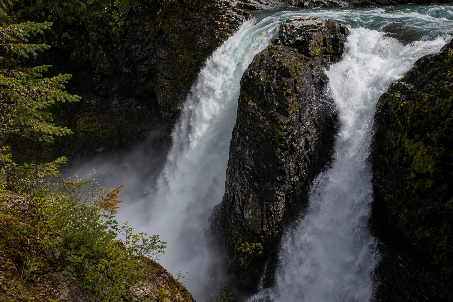
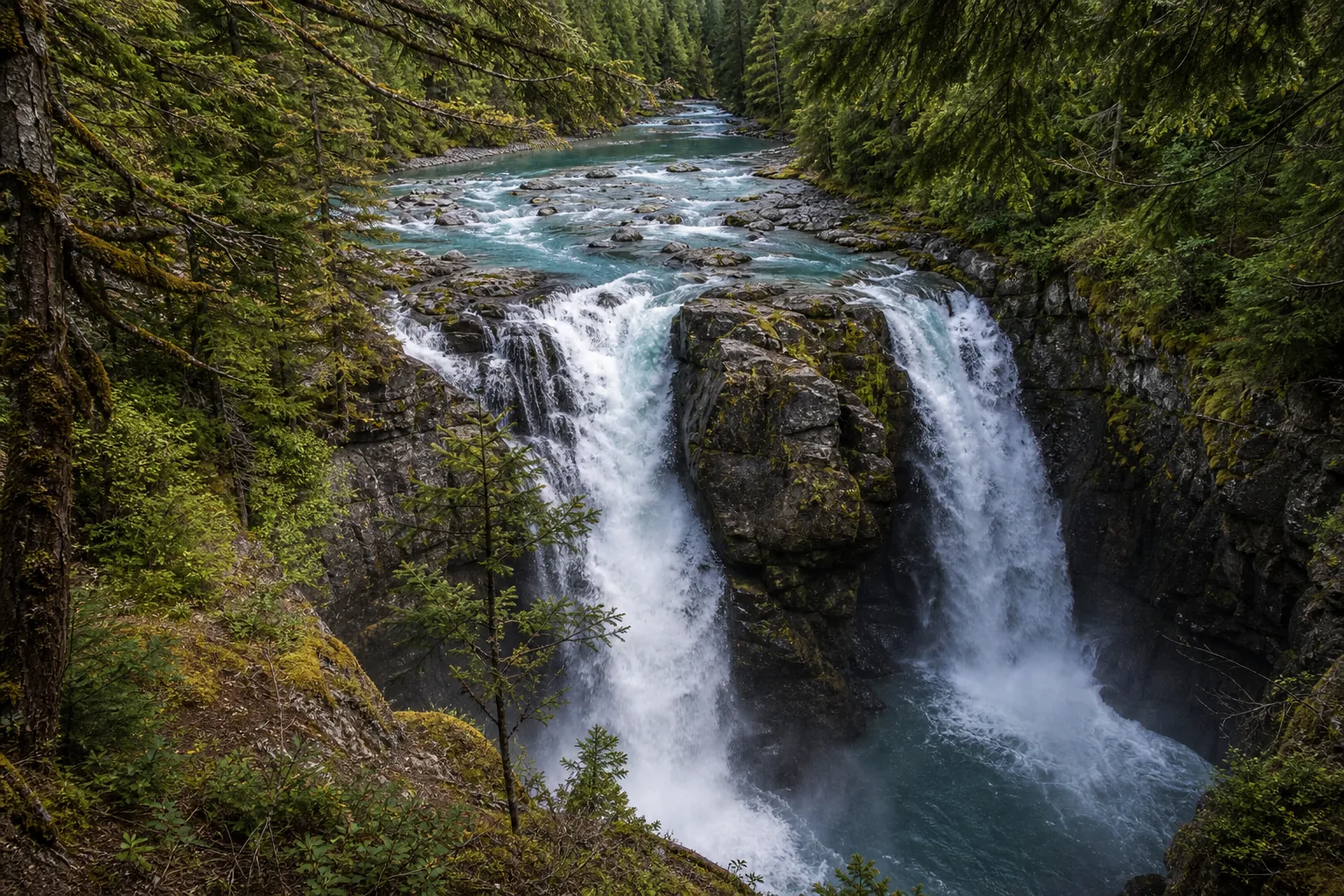
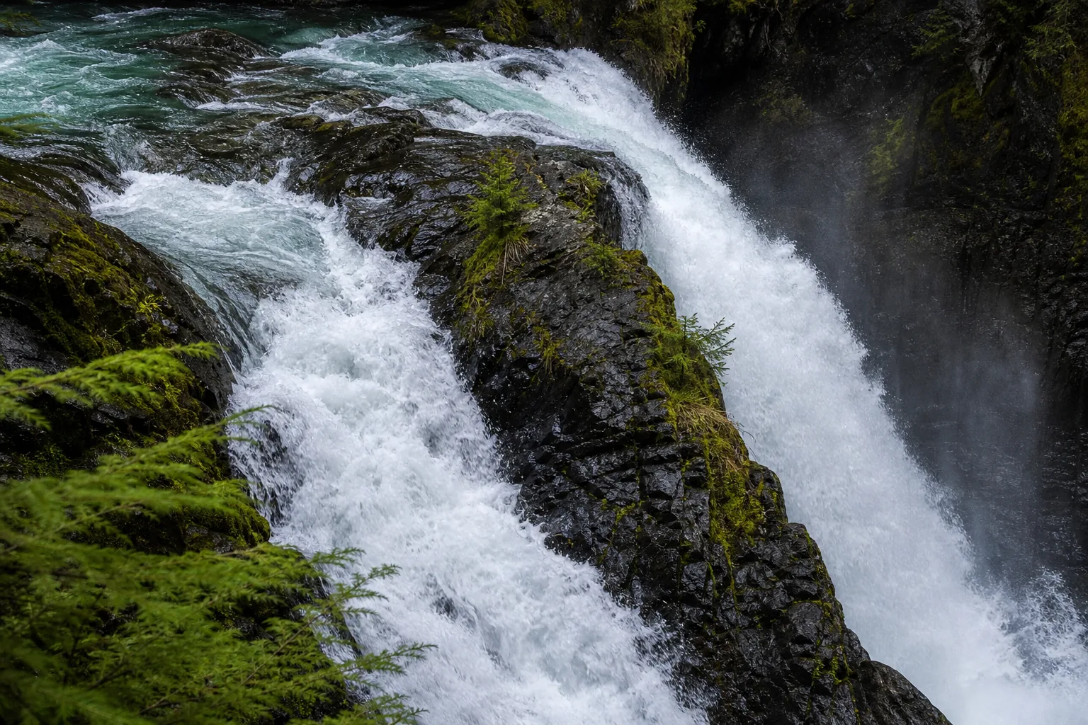
Yes for almost any May through October visit, with two clear windows that justify a special trip: late May and June for the loudest snowmelt runoff (the gauge regularly clears 1,600 cfs), and the second week of October for yellow vine maple along the gorge rim. The viewing fence is steel cable, the walk is 0.1 mile, and the falls is free. Skip a winter trip unless you are already heading to the Mt Baker Highway closure gate at Glacier and you understand the icy footing risk at the rim.

  • Less than 35 minutes east of Bellingham
  • 0.1 mile flat gravel path to the fenced overlook
  • Peak flow late May and June
  • Free trailhead, small lot, no permit
  • Stay behind the cable fence
  • Pairs with Heather Meadows in summer
Last verified May 12, 2026 Visited Desk-verified May 2026 7 sources checked
Distance 0.1 mi 0.2 mi extended
Round trip 10-30 min Flat 0.1 mile gravel path to a fenced overlook; viewing platform stays behind the cable barrier
Difficulty Easy Flat 0.1 mile gravel path to a fenced overlook; viewing platform stays behind the cable barrier
Location Glacier, WA Mt Baker-Snoqualmie National Forest
Parking Free small gravel lot at the trailhead, room for roughly 15 to 20 cars; fills on summer weekends and during fall color USFS
Transit No fixed-route transit verified Drive WA-542 east from Bellingham; no bus or shuttle service to the falls · 0 ft
Drive 35 mi 55 min from downtown
Best season May through October; peak flow late May and June Late May through June (snowmelt)
Nooksack Falls at spring runoff the falls runs above the 90th percentile (about 1,640 cfs) and the spray reaches the fence line.
Photo guide

Two angles of an 88-foot big-river plunge.

The main fenced overlook on the south rim and a slightly tightened downstream angle along the same fence line. Use the captions to pick framing before you arrive, then keep your feet behind the cable.

Nooksack Falls dropping 88 feet through a narrow basalt gorge on the North Fork Nooksack River
Nooksack Falls, hero composition
Wide view of Nooksack Falls showing the twin chutes dropping into the basalt gorge with conifers framing the rim
Twin chutes plunge 88 feet into the North Fork Nooksack gorge below the Wells Creek confluence.
Nooksack Falls in heavy spring runoff with whitewater filling both chutes and mist rising into the gorge
At spring runoff the falls runs above the 90th percentile (about 1,640 cfs) and the spray reaches the fence line.
Detail of water hitting dark basalt cliffs in the Nooksack Falls gorge with moss along the rim
Columnar basalt walls give the lower gorge its tight, vertical character below the lip.
01Is Nooksack Falls flowing right now?

Live data: USGS gauge 12205000 ↗, North Fork Nooksack River below Cascade Creek near Glacier, period of record 1996 to present. The 30-year daily-discharge median is 625 cfs; the 75th percentile is 1,060 cfs; the 90th percentile is 1,640 cfs; the highest recorded daily discharge is 10,800 cfs, from a November 1990 rain-on-snow flood event.

02How long is the walk?

0.1 mile out-and-back from the gravel lot to the fenced overlook. Flat gravel surface, no stairs, no exposure if you stay behind the cable. Total time at the falls is usually 10 to 30 minutes including photos.

03How do you get there?

From Bellingham, take WA-542 (Mt Baker Highway) east for about 33 miles past the towns of Maple Falls and Glacier. Roughly 7 miles past Glacier, watch for the brown Nooksack Falls sign and turn south onto Wells Creek Road (Forest Road 33). The trailhead is about 0.6 miles in on a maintained gravel road, passable in any car in summer.

04Is there free parking?

Free gravel lot at the trailhead, room for roughly 15 to 20 vehicles. No pass required at this site as of the last verification. The lot fills on summer weekends and during peak fall color; arriving before 10 a.m. or after 4 p.m. is usually clear.

05Does it cost money?

No. The trailhead, parking, and overlook are free. There is no Northwest Forest Pass requirement at this site, but if you continue up the highway to Heather Meadows or Artist Point, those higher-elevation trailheads do require a Northwest Forest Pass.

06Trail variants

Main overlook 0.1 mi out-and-back, 10 to 15 min, fenced viewpoint above the gorge, only legal viewing position.
Photo-first visit 0.1 mi, 20 to 30 min, overcast or shoulder-of-day light, wide angle works best from the railing.
Pair with Heather Meadows drive only, half day, continue 22 miles east on WA-542 to Picture Lake and Artist Point in summer.
Winter weather fallback drive itinerary, flexible, WA-542 closes to vehicles above Glacier in winter; verify gate status before driving.

Detailed maps and recent reviews: Falls route on AllTrails · Creek route on AllTrails

07Can you swim?

No. There is no legal water access at the falls; the river runs through a fenced gorge. The cold-water, high-velocity hydraulics in the plunge pool and the slot below the lip are documented hazards.

08Are dogs allowed?

Yes, on leash. The short overlook path is dog-friendly but the gorge edge is not; keep dogs back from the fence.

09Is it accessible?

The 0.1 mile gravel path is mostly flat and reaches the overlook without stairs, but it is not a formally accessible surface. Most mobility levels can reach the fence in dry conditions.

Field notes

Nooksack Falls at a glance.

88-foot plunge in twin chutes over basalt, North Fork Nooksack River below the Wells Creek confluence, gauge 12205000 with a 30-year median of 625 cfs, free USFS day-use site, 0.1 mile to a fenced overlook.

Height 88 ft USGS 3DEP
Type Plunge (twin chute) USGS
County Whatcom Glacier, WA
Managed by USDA Forest Service, Mt Baker-Snoqualmie National Forest USFS
Water source North Fork Nooksack River USGS
Elevation 1644 ft USGS NED
Park area 1,724,229 acres USFS
Hours Day-use access only; gate at Wells Creek Road can close in winter USFS
When to visit

Two windows that justify the trip, one that fills the gap.

Late May and June for snowmelt peak when the gauge clears 1,600 cfs. Second week of October for yellow vine maple along the rim with moderate clear flow. May and late September fill the gap with a clean 625 cfs reading and small crowds.

PEAK FLOW

Peak flowLate May through June (snowmelt)
Ice / low flowCold-snap rime in January and February
Most crowdedWeekends and midday
Best photosSunrise or weekdays

Live water context

Discharge data -- Live reading from North Fork Nooksack River below Cascade Creek near Glacier, WA (USGS 12205000) refreshes on the next build. Open the gauge link below for the current cubic-feet-per-second reading.

USGS 12205000 · North Fork Nooksack River below Cascade Creek near Glacier, WA

Why is it called Nooksack Falls?

The name Nooksack comes from the Lummi and Nuxwsa'7aq (Nooksack) words rendered roughly as noot-sa-ack or nuxwsáʼaq, often translated as people of the fern fronds or always bracken-fern roots. The river, the basin, the small town of Nooksack, and this waterfall all carry the same Indigenous name. The Nooksack Tribe's traditional territory covers the entire North Fork drainage, including the gorge below the falls. Drop the falls itself was never given a separate Indigenous proper name in the records that survive; the Anglo name Nooksack Falls dates from late 19th-century logging and hydroelectric surveys, when the river above the falls was scouted for the small 1906 Nooksack Falls Power Plant just upstream.

What else to do at Mt Baker-Snoqualmie National Forest

The falls sits inside Mt Baker-Snoqualmie National Forest, on USFS land managed from the Glacier Public Service Center about seven miles down the highway. The recreation area is informal: a small gravel pull-off, a short gravel path, a fenced overlook above the gorge, and a 1906 hydroelectric diversion structure still visible just upstream. There is no fee, no booth, no ranger on duty most days. Mt Baker Highway (WA-542) runs east from Bellingham to Artist Point at the end of the road; Nooksack Falls is the most-visited single waterfall stop on that route and the natural pairing for the alpine destinations 20 more miles up the highway.

  • The fenced overlook. A steel-cable fence runs along the gorge rim at the official viewpoint; this is the only legal viewing position and the only safe one. Multiple visitors have died after climbing past it.
  • Nooksack Falls Power Plant (1906). A small still-active hydroelectric diversion just upstream of the lip, one of the oldest continuously operating run-of-river plants in Washington.
  • Wells Creek confluence. Wells Creek joins the North Fork Nooksack a short distance above the falls; in spring you can see both flows combining before the plunge.
  • Mt Baker Highway access. Paved highway to within a half-mile of the trailhead, gravel road the rest of the way; passable in any car in summer.

Why it looks this way

Nooksack Falls drops over the dark basalt and andesite floor of a classic North Cascades glacial valley. The North Fork Nooksack drains the south face of Mt Shuksan and the north face of Mt Baker. Pleistocene glaciers carved this valley flat-bottomed and steep-walled, then meltwater from the retreating ice cut a narrow gorge into the volcanic bedrock just below the Wells Creek confluence. The lip of the falls is the resistant cap, the gorge below is the slot where softer interbeds and joint-fractured rock eroded back faster. The twin-chute character of the falls (one wide spillway with a rock divider mid-channel) is the visible signature of that joint-controlled erosion, with the river splitting around the resistant block of basalt that did not give way.
Field guide deep dive

What you cannot tell from a Tripadvisor listing.

Glacial valley geology, the live USGS reading, the honest safety record, the Mt Baker Highway day trip, and the seasonal access reality. Skim the headers, read what you need.

How Nooksack Falls formed

Nooksack Falls is a glacial-valley waterfall on volcanic bedrock. The North Fork Nooksack River drains the south face of Mt Shuksan and the north face of Mt Baker, two of the most heavily glaciated peaks in the lower 48. Pleistocene ice carved this entire valley flat-bottomed and U-shaped, the classic glacial cross-section. When the ice retreated at the end of the last glacial maximum about 14,000 years ago, meltwater rivers were left perched on a hard volcanic floor.

The bedrock here is basalt and andesite of the Chilliwack composite, a section of older volcanic rock that the Washington Geological Survey maps across this corner of the North Cascades. The river found a joint-controlled weakness in the basalt just below the Wells Creek confluence and cut a narrow slot gorge into it. The lip of the falls is the resistant cap; the slot below is where joint fractures and softer interbeds gave way fastest. The twin-chute character (two parallel flows with a rock divider mid-channel) is the visible signature of that joint-controlled erosion, with the river splitting around a stubborn block of basalt that has not yet collapsed.

Compared to a sedimentary caprock waterfall like Minnehaha Falls, where soft sandstone undercuts a limestone cap, the Nooksack mechanism is more about joint geometry than differential softness. Both fall types retreat upstream over time, but Nooksack does it slowly because basalt resists undercutting much better than sandstone.

Reading the gauge: 625 cfs is the median, not the show

The USGS gauge at North Fork Nooksack River below Cascade Creek near Glacier (12205000) has recorded daily discharge here since 1996. The 30-year daily-flow median is 625 cfs, the 75th percentile is 1,060 cfs, the 90th percentile is 1,640 cfs, and the maximum recorded daily discharge is 10,800 cfs, from a November 1990 rain-on-snow flood that pushed the entire North Fork well into flood stage.

The visual transitions matter more than the raw numbers. Below about 400 cfs (the 25th percentile, common in late August and September) the falls reads as two narrow ribbons with rock visible between them. Around 625 cfs (typical of May and late September) it is a continuous twin curtain. From 1,060 to 1,640 cfs (peak runoff) it is a heavy braided sheet with the audible roar that carries to the highway. Above 1,640 cfs the spray reaches the overlook fence and the gorge walls run brown with sediment.

Snowmelt drives the annual pattern. Discharge climbs through May, peaks in June, and tapers through July and August as the Mt Baker and Shuksan snowfields melt out. October pulses come from autumn rain rather than melt; the rare big readings (above 5,000 cfs) come from rain-on-snow events in November and December. If you are planning a trip around flow, the snowmelt peak in the last week of May or the first three weeks of June is the most reliable show on the calendar.

The safety record is honest: stay behind the cable

Nooksack Falls has killed visitors. Repeatedly. The pattern in the trip reports and local news coverage is consistent: someone climbs past the steel-cable fence at the overlook to get a closer photograph of the lip, slips on wet basalt or moss, and goes into the gorge. The water below the falls is fast, cold, and undercut, and there is no realistic way to swim out once you are in. A memorial sign at the trailhead names some of the victims; the fence exists for a documented reason and is maintained by the Forest Service.

This is not a sensational framing. It is the most important practical fact about the visit. The overlook view from behind the cable is excellent. The same view 10 feet further toward the gorge edge is not meaningfully better and is the position that produces fatalities. The basalt rim is jointed and wet most of the year; what looks like dry rock often has a thin layer of algae or rime that gives no warning before you slip.

If you are bringing kids or dogs, the fence is enough but it is not a barrier they cannot squeeze under. Keep small kids on hand at the overlook and dogs on leash. This is a stop where the practical safety rule is one short sentence: do not climb past the cable.

A Mt Baker Highway day: Nooksack, Picture Lake, Artist Point

Nooksack Falls pairs naturally with the alpine destinations at the end of WA-542. The most-used itinerary from late June through mid-October is the full Mt Baker Highway day: leave Bellingham mid-morning, stop at Nooksack Falls for 30 minutes, continue 22 miles east to Heather Meadows for lunch and the Picture Lake loop, then drive the last three miles up to Artist Point at 5,140 feet for the panorama of Mt Shuksan and Mt Baker.

Picture Lake is the iconic Mt Shuksan reflection that appears on most Washington tourism literature; it is a 0.5-mile paved loop with viewing benches and is one of the most photographed alpine lakes in North America. Artist Point sits at the literal end of the road and gives access to Bagley Lakes, Table Mountain, and Chain Lakes loop trails. The road to Artist Point typically opens in late June or early July depending on snowpack and closes in late September or early October with the first major snowfall.

If you want a second waterfall on the same loop, Marymere Falls in Olympic National Park is a similarly easy short-walk stop on a different drive (two hours south through Anacortes and the Olympic Peninsula), and Kootenai Falls in northwest Montana is the comparable big-river plunge on the Pacific Northwest side of the Continental Divide. None of them are next door, but the geology and visit format are familiar siblings.

Winter access: the Mt Baker Highway closes above Glacier

The Mt Baker Highway stays plowed year-round to the town of Glacier, about 7 miles west of the falls. Beyond Glacier, WSDOT and the Forest Service do not plow regularly, and the highway is closed to general vehicle traffic from roughly mid-November through May depending on snow. The Nooksack Falls trailhead is inside that closure most winters, which means you cannot drive to it.

What you can do in winter, if you are equipped: park at the Glacier closure gate and ski, snowshoe, or fat-bike the highway 7 miles to the Wells Creek Road turnoff and another 0.6 miles down to the trailhead. That is a 15-mile round trip and is a real winter excursion, not a casual stop. The falls itself does not fully freeze; the river volume is too high. What you get is rime ice plastered on the gorge walls and the rim, with the twin chutes still running through it.

The fence stays in place, but icy footing on the path and overlook makes a winter visit notably more dangerous than a summer one. The slip-and-fall failure mode is exactly the same in winter; the consequences are worse. Check WSDOT's Mt Baker Highway page for current closure status and the National Weather Service Seattle forecast for the SEW grid before driving up.

Photographing the basalt gorge: practical settings and timing

The gorge faces roughly north and is in shade most of the day from October through April. From May through September the lip catches direct light for a few hours around midday, but the lower gorge stays dark. The most forgiving conditions are even overcast, which keeps detail in the white water and in the dark basalt walls without forcing you to choose between blown highlights and crushed shadows.

For a single sharp frame from the fence, a focal length around 24 to 35 mm on full frame covers both chutes and the upper gorge cleanly. A polarizing filter cuts the wet-rock glare and saturates the basalt; a 1/4-second exposure at the lip and a half-second exposure for the plunge pool gives the conventional silky water look without losing all the texture. If you are shooting in heavy spring runoff, expect spray on the front element within seconds, and bring a lens cloth.

The brochure shot is the head-on twin-chute frame from the main overlook. The under-photographed alternative is the tighter downstream-rim angle that excludes the lip and focuses on the joint-fractured basalt walls of the slot gorge; in good fall light, that frame holds up against any waterfall photograph in Washington. No frame justifies stepping past the fence.

Map and route

Thirty-five minutes east of Bellingham on WA-542.

From Bellingham, take WA-542 (Mt Baker Highway) east for about 33 miles past the towns of Maple Falls and Glacier. Roughly 7 miles past Glacier, watch for the brown Nooksack Falls sign and turn south onto Wells Creek Road (Forest Road 33). The trailhead is about 0.6 miles in on a maintained gravel road, passable in any car in summer.

Photography and weddings

North-facing gorge, two working positions, USFS commercial permit only for organized shoots.

There are essentially two working positions at Nooksack Falls. The main overlook on the south rim gives the head-on view of both chutes plunging into the gorge; this is the brochure shot and the only legal one. A second slightly downstream rim angle along the same fence line tightens to the lower gorge and the basalt walls, useful when both chutes are running clean. The lower gorge and any view from below the falls are off-limits behind the cable barrier for a reason and produce most of the fatality reports tied to this site.

The gorge faces roughly north, so the falls sits in shade for most of the day from late autumn through early spring. Soft overcast is the most forgiving light because it keeps detail in the white water and in the dark basalt walls. In summer, midday light reaches the lip but leaves the lower gorge dark; the best window is the first hour after open shade in the late morning or the last hour before the sun drops behind the south rim.

Casual personal photography from the public overlook does not require a permit. Commercial filming, large-group portrait sessions, and drone flights inside the national forest can require USDA Forest Service permission, and drones are restricted near developed recreation sites and over wilderness boundaries. Tripods are fine when they do not block the overlook.

Permits

Weddings and engagements

Nooksack Falls is occasionally used for engagement portraits when the overlook is uncrowded, but it is not a ceremony venue: the overlook is narrow, the noise is high, and the safety risk for a wedding party with guests near the gorge edge is real.

Commercial portrait work and any organized event inside the national forest may require a USDA Forest Service special-use authorization; verify with the Mt Baker Ranger District before planning.

If you want a Mt Baker Highway portrait location, Picture Lake at Heather Meadows is the conventional pick in summer and gives the Mt Shuksan reflection backdrop.

Nearby waterfalls

Three Cascade waterfalls on a single Mt Baker Highway day.

Nooksack pairs naturally with the high-country stops further up WA-542. In summer, drive 20 more miles to Picture Lake, Heather Meadows, and Artist Point for the Mt Shuksan reflection and a true alpine bowl. In winter the same drive shortens to the closure gate at Glacier.

Related questions

More questions visitors ask before driving to Nooksack Falls.

Height, hike length, safety, dogs, fees, directions, winter access, and the worth-visiting answer. The full set is indexed in the FAQ schema for AI answer engines.

01How tall is Nooksack Falls?

Nooksack Falls is 88 feet tall. It drops in two parallel chutes over a basalt rim, with a rock divider mid-channel that splits the North Fork Nooksack River just below the Wells Creek confluence.

02Is Nooksack Falls safe?

The fenced overlook is safe when you stay behind the steel-cable barrier. The falls has killed multiple visitors who climbed past the fence onto wet basalt for a closer photograph. The cable exists for a documented reason and a memorial sign at the trailhead lists victims. Keep small kids on hand and dogs on leash.

03Is Nooksack Falls free?

Yes. The trailhead, parking lot, and overlook are free. No Northwest Forest Pass is required at this site, though it is required at higher-elevation trailheads further up the Mt Baker Highway at Heather Meadows and Artist Point.

04How do you get to Nooksack Falls?

From Bellingham, take Mt Baker Highway (WA-542) east for about 33 miles, past the towns of Maple Falls and Glacier. About 7 miles past Glacier, turn south at the brown Nooksack Falls sign onto Wells Creek Road (Forest Road 33). The trailhead is about 0.6 miles in on a maintained gravel road, passable in any car in summer.

05Is Nooksack Falls open in winter?

The Mt Baker Highway is plowed year-round to Glacier but closes to general vehicle traffic above Glacier from roughly mid-November through May, depending on snow. The Nooksack Falls trailhead is inside that closure most winters. You can ski, snowshoe, or fat-bike the highway from the Glacier closure gate; that is a 15-mile round trip. Check WSDOT's Mt Baker Highway page for current status.

06Is Nooksack Falls worth visiting?

Yes for almost any May through October visit, especially during the snowmelt peak in late May and June when the gauge regularly clears 1,600 cfs and the spray reaches the fence. It is one of the loudest and easiest big-river waterfalls on the Mt Baker Highway, free, with a 0.1-mile walk and a clear viewpoint. Stay behind the cable.

Sources and data

Where the Nooksack guide gets its facts.

Live discharge from USGS NWIS gauge 12205000. Land-manager rules from the USDA Forest Service Mt Baker-Snoqualmie. Geology from the Washington Geological Survey. Etymology cross-referenced with the Nooksack Indian Tribe's published cultural materials and the Lummi Nation.

USGS Streamflow: 12205000 North Fork Nooksack River below Cascade Creek near Glacier, WA waterdata.usgs.gov
USFS: Mt Baker-Snoqualmie National Forest fs.usda.gov
Access, parking, and permit rules: fs.usda.gov
Washington Geological Survey: North Cascades basalt and andesite (Chilliwack composite): Glacier bedrock dnr.wa.gov
NOAA/NWS Seattle forecast grid SEW/153,126 noaa.gov
USGS National Elevation Dataset 3DEP
Google Maps: embedded map and directions maps.google.com
Google Places: nearby restaurants and hotels places API
USDA Forest Service: Mt Baker-Snoqualmie National Forest, Nooksack Falls fs.usda.gov
USGS National Water Information System: Gauge 12205000 (North Fork Nooksack River below Cascade Creek near Glacier) waterdata.usgs.gov
Washington Trails Association: Nooksack Falls wta.org
Northwest Waterfall Survey: Nooksack Falls waterfallsnorthwest.com
Wikimedia Commons: Nooksack Falls images commons.wikimedia.org
WSDOT: Mt Baker Highway (WA-542) closure status wsdot.com
Wikipedia: Nooksack Falls en.wikipedia.org
Fact checks
Flow stats audit: 30-year daily-discharge values are taken from USGS NWIS gauge 12205000 with period of record 1996 onward; the median is 625 cfs, the 75th percentile is 1,060 cfs, the 90th percentile is 1,640 cfs, and the maximum daily reading is 10,800 cfs (November 1990 rain-on-snow event).
Height audit: 88 feet is the figure used by Washington Trails Association, Northwest Waterfall Survey, and myhikes.org; cross-referenced and consistent across three independent sources.
Safety audit: the fatal-fall pattern is documented in WTA trip reports, Reddit r/PacificNorthwest threads, and local news coverage of multiple incidents; a memorial sign at the trailhead names victims. Editorial copy describes the hazard honestly and points readers to the fence as the practical rule.
Etymology audit: the Nooksack name traces to Lummi and Nooksack Tribe sources; rendered roughly as people of the fern fronds or always bracken-fern roots; Indigenous proper name for the falls itself is not recorded in surviving sources.
Access audit: WA-542 closure-above-Glacier-in-winter is reconciled with WSDOT mountain-pass real-time data and the Mt Baker-Snoqualmie National Forest recreation page; fee status reflects current USFS posting (no Northwest Forest Pass required at this site).
Corrections: [email protected]