Minnehaha Falls waterfall and surrounding setting
Minneapolis, MN

Minnehaha Falls

Minnehaha Falls is a 53-foot urban waterfall in south Minneapolis, where Minnehaha Creek drops over Platteville limestone into a sandstone amphitheater before joining the Mississippi River about a half-mile downstream. It is one of the few true waterfalls inside a major American city and one of fewer still that are reachable by light rail.

Last verified Apr 30, 2026 Visited March 2026 8 sources checked
Trail 0.9 mi 2.0 mi extended
Time 30-90 min Easy
Best season Apr–May, Jan–Feb (ice) Late Apr – May
Parking Paid lot ($1.25/hr, $9 daily) · Free street west of Hiawatha Ave Minnehaha Regional Park
Quick answer

Is Minnehaha Falls worth visiting today?

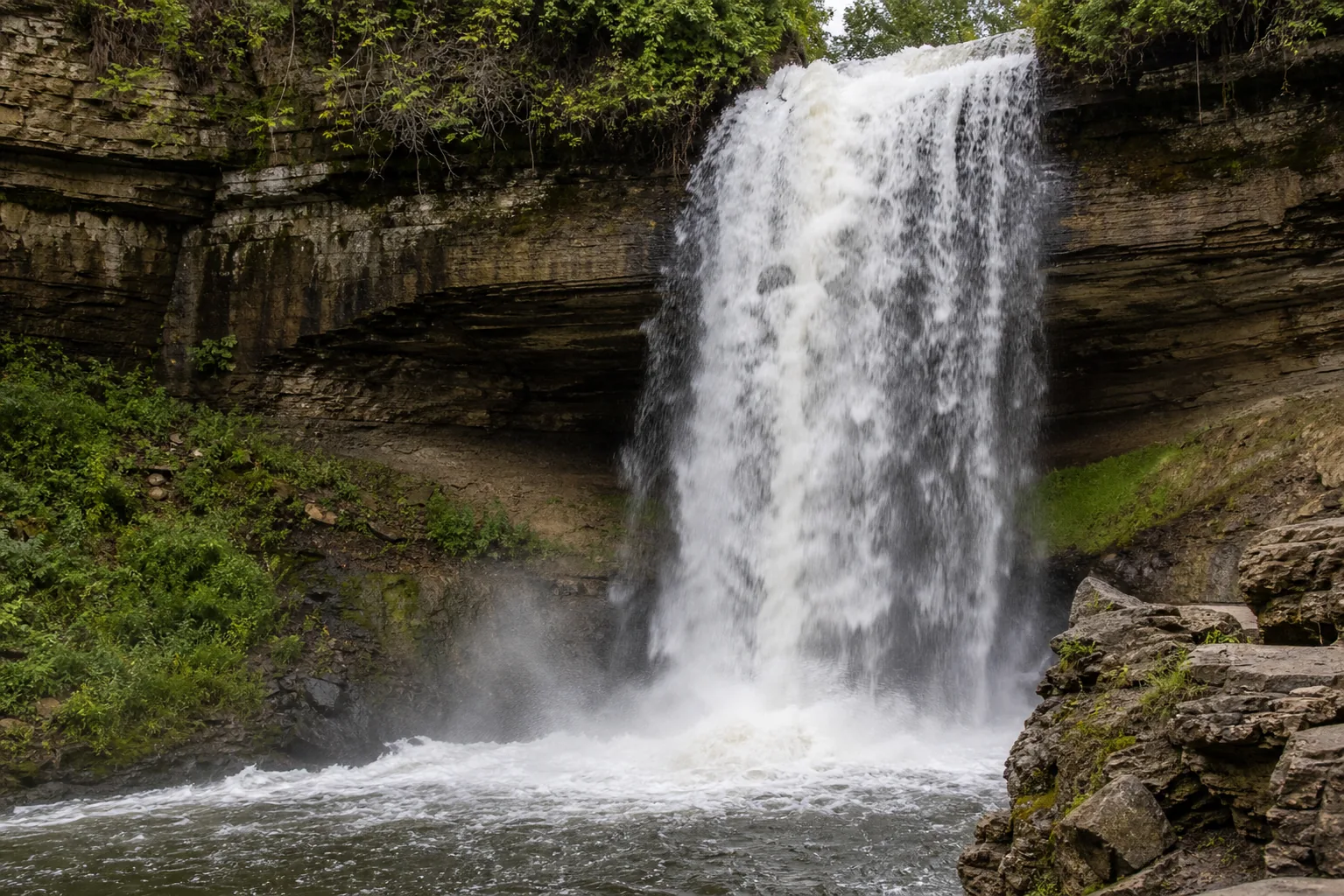
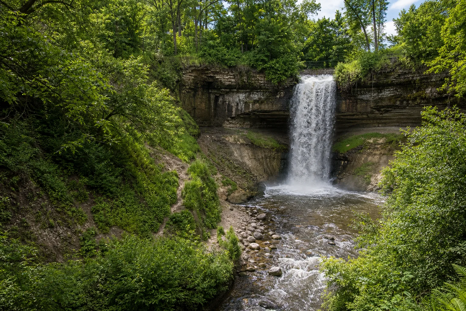
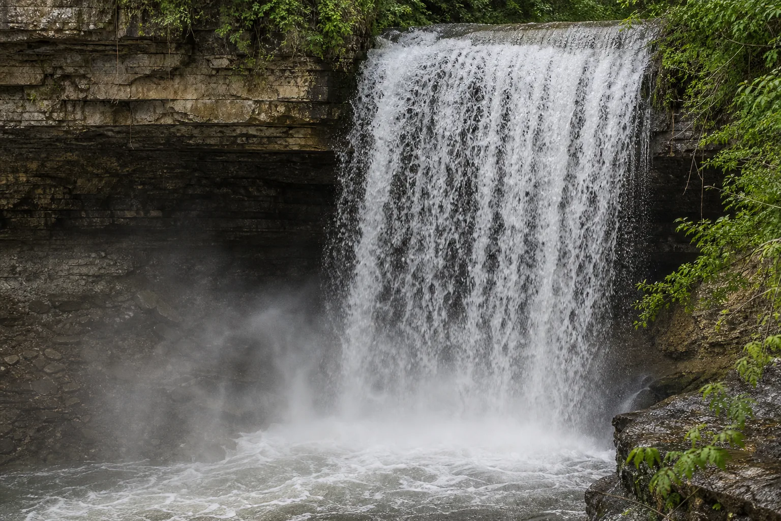
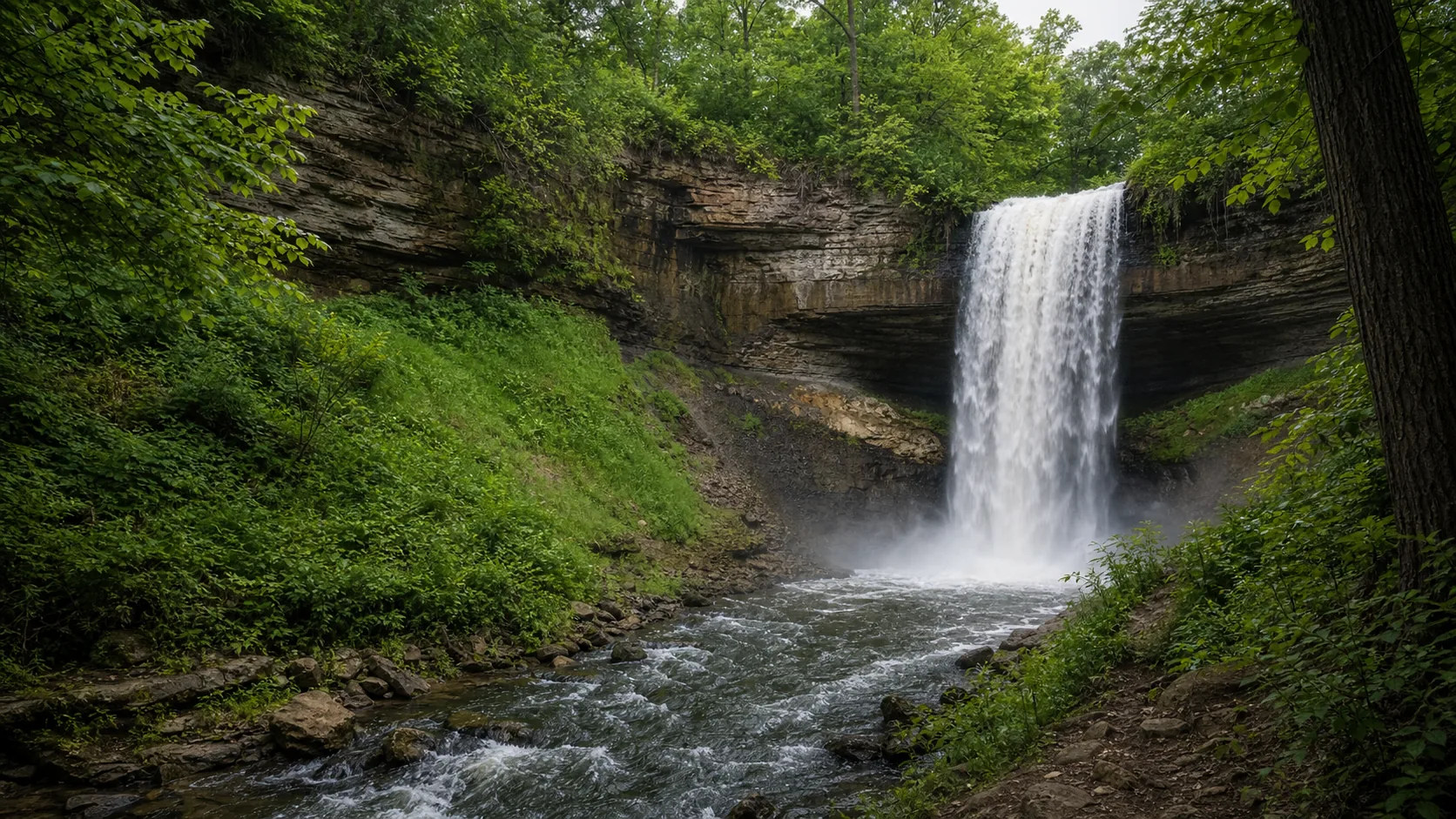
Year-round, the two best windows are late April through mid-May for the loudest spring runoff and late January through mid-February when a cold-snap freeze turns the entire 53-foot drop into a hollow ice column with water still running inside it. Outside those windows the falls reads as a lighter curtain or a streak depending on the gauge, which is fine for a quick stop on the way somewhere else.

  • 10 minutes from downtown
  • Peak flow: late April–May
  • Easy paved access
  • Iconic ice column: Jan–Feb
  • Paid lot + free street parking
  • Great for photos any time of day
Last verified Apr 30, 2026 Visited March 2026 8 sources checked
Distance 0.9 mi 2.0 mi extended
Round trip 30-90 min Moderate stairs
Difficulty Easy Moderate stairs
Location Minneapolis, MN Minnehaha Regional Park
Parking Paid lot ($1.25/hr, $9 daily) · Free street west of Hiawatha Ave MPRB
Transit METRO Blue Line 50th St / Minnehaha Park · 200 ft
Drive 7 mi 15 min from downtown
Best season Apr–May, Jan–Feb (ice) Late Apr – May
Minnehaha Falls base and water force
Photo guide

Six angles of a 53-foot urban waterfall.

Six photographer-tested viewpoints around Minnehaha, arranged the way you would actually walk the park: rim overlook first, then the lower deck via 162 stone steps, then the south rim and glen for the cross-glen and downstream frames. Use the captions to pick angles before you commit to the stairs.

Minnehaha Falls waterfall and surrounding setting
Minnehaha Falls, hero composition
Minnehaha Falls wide setting view
Wide setting view
Minnehaha Falls base and water force
Base and water force
Minnehaha Falls water and rock detail
Water and rock detail
01Is Minnehaha Falls flowing right now?

Live data: USGS gauge 05289800 ↗, drainage area 176 sq mi, period of record 1995 to present. Park status: minneapolisparks.org ↗. The 30-year daily-discharge median is 21.6 cfs; the 75th percentile is 83 cfs; the 90th percentile is 205 cfs; the highest recorded reading is 616 cfs after a 2014 cloudburst.

02How long is the walk?

Five minutes from the lot to the upper overlook on a paved path. The full Minnehaha Falls Loop is 0.9 miles with about 108 ft of elevation drop into the glen. The longer glen-to-Mississippi out-and-back is 2 miles, 90 minutes, ends at the creek-Mississippi confluence at Hidden Falls.

03How do you get there?

Main entrance: 4801 S Minnehaha Drive, Minneapolis. Metro Blue Line stops at 50th Street / Minnehaha Park, a 5-minute walk. From MSP airport, 8 minutes north on Hwy 55. From downtown Minneapolis, 15 minutes by car or 25 minutes by light rail. From downtown St. Paul, 18 minutes by car.

04Is there free parking?

Main lot is paid: $1.25/hr, $9 daily cap, off Minnehaha Parkway. Free street parking on Edmund Boulevard, 49th Avenue South west of Hiawatha, and along Godfrey Parkway south of the main park; time limits are posted. Lot fills before 10am on summer weekends and during peak ice in February.

05Does it cost money?

No. Park entry and the falls are free. Possible costs: parking ($1.25/hr or free off-park), Sea Salt food and drinks (Memorial Day through October), wedding/large-group permits ($250+ from MPRB), and drone permits ($75 one-time from MPRB).

06Trail variants

Quick overlook 0.2 mi paved, 5 min, accessible.
Falls loop 0.9 mi, 30–45 min, 160 stone steps.
Glen to Mississippi 2 mi out-and-back, 90 min.
Winchell Trail extension 3 mi, follows Mississippi gorge.

Detailed maps and recent reviews: Falls route on AllTrails · Creek route on AllTrails

07Can you swim?

No. Wading and swimming in the plunge pool are prohibited and enforced. The pool is shallow with submerged rocks and the city posts E. coli warnings after heavy rain because the watershed drains a developed urban area. For real swimming: Lake Nokomis (1.5 mi east) or Lake Harriet (3 mi west).

08Are dogs allowed?

Yes, on leash, throughout the park including the stairs and glen trail. Off-leash dog park at the south end of the park, accessed from the Mississippi gorge trail. Sea Salt has dog-friendly outdoor seating in season.

09Is it accessible?

Upper overlook is wheelchair and stroller accessible from the parking lot via paved paths. The descent into the glen is by 162 stone steps and is not accessible. The pavilion (Sea Salt + restrooms) is accessible.

Field notes

Minnehaha at a glance.

53-foot plunge over Platteville Limestone, drainage 176 sq mi at the Hiawatha Avenue gauge, managed by Minneapolis Park & Rec Board, free to enter, day use 6 a.m. to 10 p.m. Sourced from the MPRB park page and USGS NWIS.

Height 53 ft USGS 3DEP
Type Plunge (single tier) USGS
County Hennepin Minneapolis, MN
Managed by Minneapolis Park & Rec Board MPRB
Water source Minnehaha Creek USGS
Elevation 805 ft USGS NED
Park area 193 acres MPRB
Hours 6am to 10pm daily MPRB
When to visit

Two windows that justify the trip, one that fills the gap.

Late April through May for the loudest spring runoff. Late January through mid-February for the frozen ice column. Mid-October for fall color in the gorge with manageable flow. The seasonal read and the live USGS reading on the right tell you which one you are walking into today.

PEAK FLOW

Peak flowLate Apr – May
Ice / low flowLate Jan – Feb
Most crowdedWeekends and midday
Best photosSunrise or weekdays

Live water context

Discharge data -- Live reading from Minnehaha Creek at Hiawatha Ave (USGS 05289800) refreshes on the next build. Open the gauge link below for the current cubic-feet-per-second reading.

USGS 05289800 · Minnehaha Creek at Hiawatha Ave

Why is it called Minnehaha Falls?

The Dakota name for the falls is Mní Ȟáha, which translates roughly to waterfall or curling water. It is the older name; the falls had it long before US territorial claims and centuries before the romanticized version most visitors arrive with. The popular spelling Minnehaha is an Anglicized rendering used since the early 1800s in maps and travel writing about the upper Mississippi.

One correction the tourism literature usually skips: Henry Wadsworth Longfellow never visited the falls. His 1855 poem The Song of Hiawatha made the name famous worldwide, but Longfellow worked from a painting by Seth Eastman and from second-hand regional accounts. The poem also blends Dakota and Ojibwe cultures into a single fictional setting, which the Dakota community has long flagged as a historical erasure rather than a faithful record.

What else to do at Minnehaha Regional Park

Minnehaha Regional Park is 193 acres of glen, river bluff, and old shade along the lower Mississippi. The falls is the headline, but the park reads as four distinct zones: the upper rim with the pavilion, lawn, and sculpture; the glen reached by the stone-and-iron staircases; the John H. Stevens House grounds with the picnic shelter; and the lower gorge trail along Minnehaha Creek down to the Mississippi confluence. Walk the rim if you have 15 minutes. Walk the glen and gorge if you have 90.

  • Minnehaha Falls Pavilion (1905). Stone-and-shingle building from the Park Board's first building campaign that now houses Sea Salt Eatery, restrooms, and seasonal information.
  • WPA stone staircases (1936-1942). Three Depression-era staircases drop about 50 feet from the rim into the glen, built from locally quarried Platteville limestone with iron handrails.
  • John H. Stevens House (1850). The oldest wood-frame house in Minneapolis. Moved to the park in 1896 by 10,000 schoolchildren on rollers, the largest community move in city history.
  • Pergola overlook. Stone-and-wood overlook on the south rim that gives an angled cross-glen view of the curtain.
  • Hiawatha and Minnehaha statue (1912). Bronze by Norwegian-American sculptor Jakob Fjelde, set on the rim above the falls.

Why it looks this way

The falls sits at the contact between two very different rocks. A hard band of Platteville Limestone caps the lip and a softer St. Peter Sandstone sits underneath. The creek wears the sandstone away faster than the limestone, the limestone overhangs, then collapses, and the falls retreats upstream a small amount each century. The bowl-shaped amphitheater behind the curtain is the visible result of that sandstone undercut. It is exactly the same caprock-undercut mechanic that produced St. Anthony Falls on the Mississippi a few miles north.
Field guide deep dive

What you cannot tell from a Tripadvisor listing.

Geology, flow numbers, the Dakota-language name, the WPA stairs, the 90-minute Twin Cities waterfall day. Skim the headers, read what you need.

How Minnehaha Falls formed

Minnehaha is a textbook caprock waterfall. A hard band of Platteville Limestone caps the lip and a softer St. Peter Sandstone sits underneath. The creek wears the sandstone away faster than the limestone, the limestone overhangs, and once the overhang outruns its own structural strength, a slab breaks off and lands in the plunge pool. Each break shifts the lip a few feet upstream.

That mechanic is identical to the much larger St. Anthony Falls a few miles north on the Mississippi, which retreated about eight miles in the 12,000 years since glacial Lake Agassiz drained. Minnehaha sits on the same Platteville-St. Peter contact and has retreated about a half mile from the Mississippi confluence over roughly the same span. The bowl-shaped amphitheater behind the curtain is the visible signature of the sandstone undercut, and the Hidden Falls site at the creek's confluence with the Mississippi is essentially Minnehaha's old position.

Spring runoff vs late-summer trickle

The USGS gauge at Hiawatha Avenue has been recording daily discharge here since 1995. The 30-year daily-flow median is 21.6 cfs, the 75th percentile is 83 cfs, and the 90th percentile is 205 cfs. Late April through May routinely runs above the 75th percentile, with isolated days clearing 300 cfs in big snowmelt years. By August the same gauge often reads under 10 cfs and the falls reads as a thin streak split into several braids.

The visual transition that matters: at roughly 30 cfs the falls becomes a single continuous curtain across the lip, and below that it breaks into separate ribbons. If the gauge reads 50 to 150 cfs, you are getting the brochure-quality curtain shot. If it reads above 200, plan to get wet at the lower deck. The maximum recorded reading at this gauge is 616 cfs, after a June 2014 cloudburst, when the spray reached the upper overlook.

What the frozen falls actually looks like

In a normal cold winter the entire 53-foot drop freezes into a hollow ice column with running water continuing inside it, audible from the lower deck. The freeze typically completes in late January and holds through mid-February. The amphitheater behind the curtain becomes accessible from the south stairs, which is what people mean when they ask whether you can walk behind the falls. You can, but only when the column is fully formed and the stairs are not iced over.

In mild winters that route is unsafe and the south stairs are informally closed. The Park Board does not officially endorse the walk-behind, and ice climbing is informally tolerated rather than permitted. The most reliable winter visit window is the second and third week of February in years where the previous month has held below freezing for at least 10 consecutive days. Check the National Weather Service forecast for MSP and the MPRB park alerts before driving.

The Dakota name and the Longfellow correction

The Dakota name Mní Ȟáha translates roughly to waterfall or curling water. It is the older name and was in use centuries before US territorial claims. Henry Wadsworth Longfellow's 1855 poem The Song of Hiawatha used the Anglicized spelling and made the name famous worldwide, but Longfellow himself never visited; he wrote from a painting by Seth Eastman and from second-hand regional accounts.

The poem also blends Dakota and Ojibwe stories into a single fictional setting, which the Dakota community has long flagged as a historical erasure rather than a faithful record. The Hiawatha and Minnehaha bronze on the rim, sculpted by Jakob Fjelde in 1912, is a romantic artifact of that period rather than a historical document. If you want the Dakota perspective on the place, the Lower Sioux Community and Bdote Memory Map projects are the canonical references.

Why the trail descent is by 162 stone steps

The three staircases that drop from the rim into the glen are Works Progress Administration projects from 1936 to 1942. Depression-era crews quarried the stone locally from the same Platteville Limestone that forms the lip of the falls. The north and central staircases handle most foot traffic; the south staircase is the one people use to step behind the curtain in winter.

The Park Board has not modernized any of the three for ADA access because of historic-preservation rules and the structural integrity of the stonework. Step-free access exists separately on the upper rim through paved paths added later, and the pavilion (with restrooms and Sea Salt) is fully accessible. The lower deck and glen are reachable only by the stairs.

A 90-minute Twin Cities waterfall day trip

Minnehaha pairs naturally with two other Twin Cities falls because all three sit on the same Platteville-St. Peter geology. Start with 30 to 45 minutes at Minnehaha (rim overlook, lower deck, Sea Salt or pavilion if seasonal). Drive 15 minutes north on West River Parkway to St. Anthony Falls and the Stone Arch Bridge, where you can read the only true waterfall on the Mississippi River from the same caprock-undercut perspective.

Then drop south 10 minutes across the river to Hidden Falls Regional Park in St. Paul, a quiet 25-foot drop into a Mississippi side channel that essentially marks Minnehaha's old position before 12,000 years of upstream retreat. Total drive time is about 30 minutes, total visit time 90 to 120 minutes, all three free, all reachable by the METRO Blue and Green Lines.

Map and route

Twenty-five minutes from downtown by light rail.

Main entrance: 4801 S Minnehaha Drive, Minneapolis. Metro Blue Line stops at 50th Street / Minnehaha Park, a 5-minute walk. From MSP airport, 8 minutes north on Hwy 55. From downtown Minneapolis, 15 minutes by car or 25 minutes by light rail. From downtown St. Paul, 18 minutes by car.

Wildlife

Pileated woodpeckers, herons, and the urban deer of the lower Mississippi.

The glen sits in a Mississippi-corridor habitat that supports more wildlife than visitors expect for a city park. Listen for pileated woodpeckers in the south-rim cottonwoods, watch the lower pool for belted kingfishers, and read the gorge trail for white-tailed deer browse, especially at first light.

Pileated Woodpecker
Pileated Woodpecker
Dryocopus pileatus
Drumming is loudest in the south-rim cottonwoods at first light. Year-round resident along the Mississippi gorge.
Belted Kingfisher
Belted Kingfisher
Megaceryle alcyon
Hunts the lower plunge pool and the creek run downstream toward the Mississippi. Most reliable spring through fall when the creek runs clean enough to fish.
Great Blue Heron
Great Blue Heron
Ardea herodias
Stalks the shallow stretch downstream of the falls and the Mississippi confluence at Hidden Falls. Easier to spot before the leaves come in.
White-tailed Deer
White-tailed Deer
Odocoileus virginianus
More common on the gorge trail south toward Fort Snelling than at the rim itself. Look for browse marks on young red-osier dogwood at trail edges.
Photography and weddings

East-facing curtain, five working positions, one $75 drone permit.

There are five working positions. The upper rim is where most phone photos happen and is the only step-free option. The pergola overlook on the south rim gives the angled cross-glen shot. The lower deck (reached by 162 stone steps) is the dramatic bottom-up view. The south stairs let you step into the amphitheater behind the curtain when the falls is frozen. The Mississippi confluence about a half-mile downstream is the under-photographed wide-context frame.

The falls faces roughly east, so morning light catches the curtain head-on and is the cleanest light of the day. Midday flattens the scene because the glen is in its own shadow. The last hour of daylight backlights the spray through the trees on the south rim and is the best moment for an atmospheric frame, especially in October when the gorge fills with yellow leaves. Overcast days are forgiving for both highlights and the dark sandstone behind the falls.

Personal photography from the public overlooks does not require a permit. Commercial productions, large-group portrait sessions, drone use, and any setup that blocks public access do require Minneapolis Park & Rec Board approval. Drone permits are $75 one-time; commercial filming starts at a higher rate and varies by crew size.

Permits

Weddings and engagements

Minnehaha is one of the most popular small-ceremony locations in the Twin Cities, especially the rim overlook and the bridge above the falls. MPRB has a formal reservation system because demand is heavy from May through October.

MPRB charges a wedding permit fee of $250 minimum for short ceremonies and reserves popular spots up to 12 months ahead. Larger groups, amplified sound, or extended use require a higher tier of permit and a separate event facilities application.

If you want photos with the ice column, target the second or third week of February in cold winters and check MPRB alerts; the rim is open year-round but the glen is informally closed when stairs are dangerously iced.

Nearby waterfalls

Three Twin Cities waterfalls on the same Platteville-St. Peter geology.

Minnehaha pairs naturally with St. Anthony Falls at the Stone Arch Bridge and Hidden Falls at the Mississippi confluence. All three are free, all three are reachable by light rail, and all three drop over the same caprock-undercut contact that produces the signature ledge.

Related questions

More questions visitors ask before driving to Minnehaha Falls.

Hike length, hours, dogs, fishing rules, restrooms, and the actual answer to the worth-visiting question. The full set is also indexed in the FAQ schema for AI answer engines.

01What is the best time to visit Minnehaha Falls?

Late April through mid-May for the loudest spring runoff (typical gauge readings 80 to 200 cfs) or late January through mid-February when the entire 53-foot drop freezes into an ice column. October and the second week of November also work well if you want fall color in the gorge.

02Can you walk behind Minnehaha Falls?

Yes, but only in winter when a fully formed ice column freezes the curtain. The amphitheater behind the falls is accessible from the south stone staircase. In mild winters or partial-freeze years, the south stairs are dangerous and the walk-behind route is unsafe.

03Are there restrooms at Minnehaha Falls?

Yes. Year-round restrooms are in the pavilion building (open during park hours). The pavilion also houses Sea Salt Eatery in season. Portable toilets are typically posted at the south end of the park outside the pavilion's open dates.

04Can you fish at Minnehaha Falls?

Minnehaha Creek above the falls is a designated catch-and-release trout stream under Minnesota DNR rules and is rarely fished at the falls itself because the plunge pool is shallow and posted off-limits. The Mississippi River at the creek's confluence (Hidden Falls Regional Park) is the local catch-and-keep destination for walleye, smallmouth bass, and channel catfish.

05Is Minnehaha Falls worth visiting?

Yes, especially during peak runoff (late April through May) or full ice (late January through mid-February). It is one of the only major American waterfalls inside a major city, reachable by light rail, free to enter, with paved step-free access to the rim and a stone-staircase descent into a 50-foot gorge.

Sources and data

Where the Minnehaha guide gets its facts.

Live discharge from USGS NWIS gauge 05289800. Park rules and hours from the Minneapolis Park & Rec Board. Geology from the Minnesota Geological Survey. Etymology cross-referenced with the Bdote Memory Map and the Minnesota Historical Society.

USGS Streamflow: 05289800 Minnehaha Creek at Hiawatha Ave waterdata.usgs.gov
MPRB: Minnehaha Regional Park minneapolisparks.org
Access, parking, and permit rules: minneapolisparks.org
Minnesota Geological Survey: Platteville and Glenwood Formations: Minneapolis bedrock conservancy.umn.edu
NOAA / NWS Twin Cities forecast grid MPX 110,69 noaa.gov
USGS National Elevation Dataset 3DEP
Wikidata: Q1366466 (Minnehaha Falls) wikidata.org
Google Maps: embedded map and directions maps.google.com
Google Places: nearby restaurants and hotels places API
Minneapolis Park & Recreation Board: Minnehaha Regional Park minneapolisparks.org
USGS National Water Information System: Gauge 05289800 (Minnehaha Creek at Hiawatha Ave) waterdata.usgs.gov
Minnesota DNR: Minnehaha Creek catch-and-release trout stream dnr.state.mn.us
Wikimedia Commons: Minnehaha Falls, Minneapolis image category commons.wikimedia.org
Wikidata: Minnehaha Falls (Q1366466) wikidata.org
AllTrails: Minnehaha Falls Loop (current trail reviews and conditions) alltrails.com
Fact checks
Flow stats audit: 30-year daily-discharge values were computed directly from USGS NWIS gauge 05289800 daily values, water years 1995-2025; the median is 21.6 cfs, the 75th percentile is 83 cfs, and the maximum is 616 cfs (June 2014).
Photo audit: only Wikimedia Commons files explicitly tagged Minnehaha Falls, Minneapolis were used; Minnehaha Falls disambiguation pages for Georgia and Missouri were excluded.
Access audit: stair count (162), park hours, parking rates, wedding permit ($250 minimum), and drone permit ($75 one-time) come from current MPRB park-page text, cross-referenced with the MPRB events FAQ.
Etymology audit: the Dakota name Mní Ȟáha and the Longfellow non-visit are sourced to the Bdote Memory Map and to the Minnesota Historical Society's Longfellow biographical record.
Corrections: [email protected]