Six waterfalls through the north Georgia Blue Ridge, anchored on Helen.
Six stops in the Chattahoochee-Oconee National Forest north of Helen, GA. About two hours of total driving across one long day or a relaxed Helen-overnight weekend.
The north Georgia mountains are the southern end of the Blue Ridge Province, and they pack a remarkable density of waterfalls into a small area of the Chattahoochee-Oconee National Forest. Six of the best sit within reach of Helen, the Bavarian-themed town on the Chattahoochee River that has become the regional waterfall hub. This route threads them in a clean east-to-northwest arc that starts above Helen, loops through the Dukes Creek and Richard Russell Scenic Highway corridor, ducks into Union County for Helton Creek and DeSoto, and finishes 40 minutes northwest at Long Creek Falls near the Benton MacKaye Trail.
The geology is consistent across the route. All six falls drop over Tallulah Falls Quartzite or related metamorphic basement rock of the southern Blue Ridge, the eroded core of an ancient mountain belt that was once Himalayan in scale. The water sources are different from the Pacific Northwest analog: no glacial meltwater, no volcanic aquifer, just orographic rain off the southern Appalachians and groundwater seeping out of the resistant quartzite shelves. That makes flow heavily season-dependent. Spring and after rain events are loud; late summer can be a trickle.
This is a route that works as either a single long day (sunrise start, sunset finish at Long Creek) or a relaxed two-day weekend with a Helen overnight between Dukes Creek and Helton Creek. The Helen overnight is the locally classic version because it puts you close to Anna Ruby, Blue Hole, and Dukes Creek on Day 1 and lets you sleep before the longer Day 2 drive to Union and Fannin counties. Total driving is roughly two hours across all six stops, lighter than any comparable Pacific Northwest route.
Best suited to: weekenders from Atlanta (Helen is 90 minutes north via GA-400 and GA-75), families who want a Helen base with short trails, and photographers chasing rhododendron bloom in mid-May and peak fall color in mid to late October.
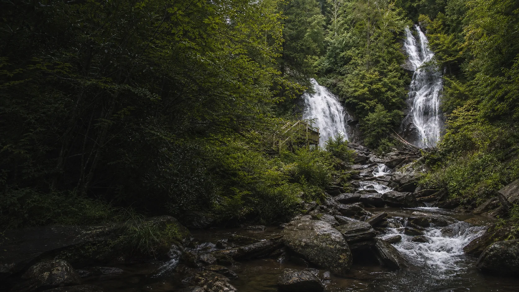
Start at 9 a.m. when the visitor center opens. Drive north out of Helen on GA-75 to the Anna Ruby Falls Scenic Area, a $6 per-adult admission site inside Chattahoochee National Forest. The 0.4-mile paved trail climbs gently to a viewing deck below the twin falls (153-foot Curtis Creek and 50-foot York Creek). The visitor center has clean restrooms and a small bookstore worth 15 minutes. Pair with Smith Creek Trail if you want a longer 4.6-mile downhill option to Unicoi State Park. Pack a light jacket; the gorge stays cool even on hot summer mornings.
15 min · 6 mi from previous stop1 hr 0 min on site
Drive back through Helen and west toward the Dukes Creek Falls Recreation Area on GA-348. Park once, pay the $5 per-vehicle GoFindOutdoors fee, and take the Dukes Creek Falls trail to the short Blue Hole spur. The Blue Hole pool is the swimming-hole highlight of the north Georgia waterfall route, but there is no lifeguard and conditions change after storms. Pack water shoes if you plan to wade.
5 min · 1 mi from previous stop1 hr 30 min on site
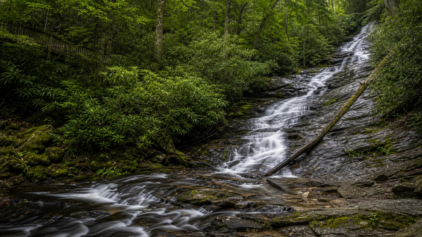
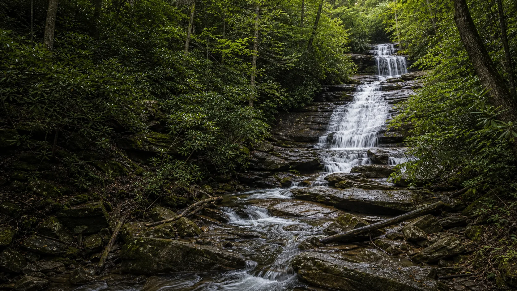
Stay at the same Dukes Creek Falls recreation area and continue to the main observation deck; the $5 per-vehicle fee covers the Blue Hole spur and Dukes Creek Falls on the same visit. The 1-mile round trip drops 300 feet on switchbacks and stairs to a viewing platform where Davis Creek falls into the Dukes Creek gorge; the falls are a 250-foot multi-tier scene. This is the steepest descent of the route, so save knees for here rather than spending them on Anna Ruby earlier. Eat lunch back in Helen or at the small picnic area at the trailhead before driving on.
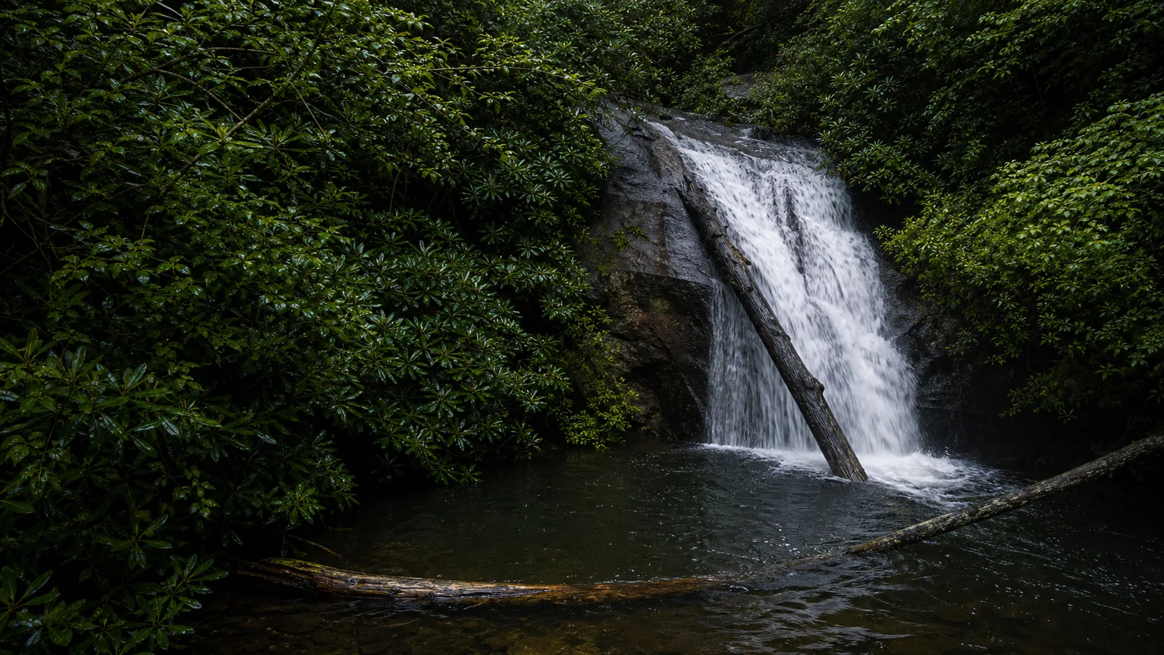
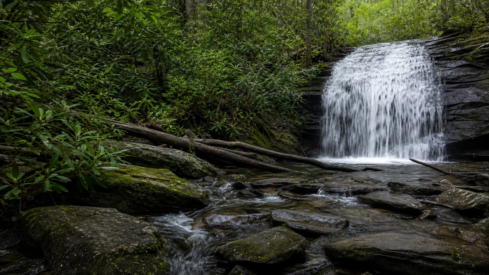
Continue northwest on GA-348 (Richard Russell Scenic Highway) over Hogpen Gap into Union County, then turn off onto Helton Creek Road, the last 2 miles of which are gravel and a bit rough but passenger-car passable in dry weather. Park at the small Forest Service trailhead lot. The 0.3-mile path drops to a two-tier waterfall: an upper 30-foot cascade and a lower 50-foot drop with a small pool. Free, no fee. Plan around midday so the gravel road is dry; in heavy rain consider skipping or using a higher-clearance vehicle.
12 min · 3 mi from previous stop1 hr 15 min on site
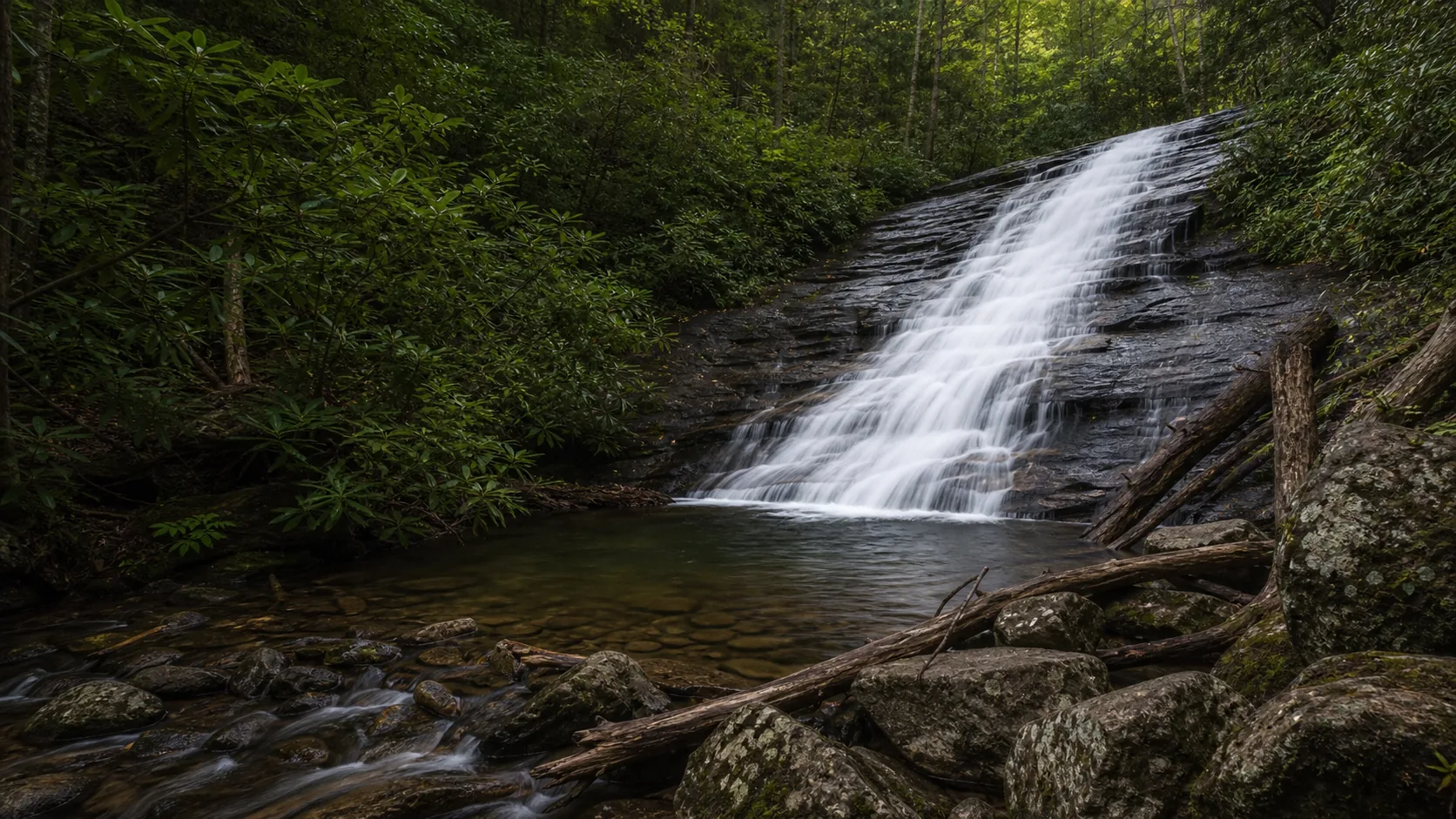
Twelve minutes west on US-19/129 to the DeSoto Falls Recreation Area on Frogtown Creek. Park at the day-use lot ($5 per vehicle, Forest Service). The 2-mile loop visits three falls (Lower 35-foot, Middle 90-foot, Upper 200-foot) on a maintained trail with footbridges. This is the meatiest hike of the route and the only one with three named falls on a single loop. Allow 75 minutes including stops. Bring trekking poles if you have knee issues; the descent to the Middle Falls viewing deck is the steepest segment.
40 min · 15 mi from previous stop1 hr 30 min on site
Forty minutes northwest via Suches and Cooper Creek Scenic Area to the Three Forks area near Blue Ridge, GA. Park at the Three Forks trailhead off Forest Road 58; the road is gravel for the last 4 miles and rougher in wet conditions. The 1-mile round trip follows the Benton MacKaye Trail through hemlock and rhododendron to a 50-foot Long Creek plunge. This is the route's most remote-feeling walk and the only one that intersects the Appalachian Trail corridor (the AT junction is 0.3 miles upstream). Finish here at golden hour; head to Blue Ridge or Ellijay for dinner.
Why this route, in this order.
The order is built around the Helen pivot. The first three stops (Anna Ruby, Blue Hole, Dukes Creek) form a compact Helen-area morning cluster. Doing them in that order moves you from the highest-flow falls of the route (Anna Ruby, fed by Curtis and York creeks at the head of Smith Creek) to the shared Dukes Creek Falls trailhead, where the same $5 per-vehicle concession fee covers both the Blue Hole spur and the Dukes Creek observation deck. Visiting that trailhead in the morning gives you the best shot at parking before the GA-348 lot fills.
The middle of the route (Helton Creek and DeSoto) shifts you onto the Richard Russell Scenic Highway over Hogpen Gap and into Union County. This is the prettiest driving on the route and the natural early-afternoon segment, with Brasstown Bald views and dogwood corridors in spring. Helton Creek is a short walk to a two-tier scene; DeSoto follows up with three falls on a 2-mile loop that is the meatiest hiking segment of the day.
Long Creek Falls is last for a reason. It sits 40 minutes northwest near Three Forks where the Appalachian Trail, the Benton MacKaye Trail, and the Duncan Ridge Trail converge. The forest-road drive in is the longest of the route, and the 1-mile round trip on the Benton MacKaye Trail is the route's most remote-feeling walk. Ending here positions you for a Blue Ridge, GA dinner stop on the way back to Atlanta and gives the day a satisfying we-went-deeper feel rather than petering out at the busier Helen-cluster stops.
Food, fuel, and lodging.
Helen is the spine of this route. It is a small Bavarian-themed mountain town with restaurants, gas, two grocery options, river-tubing outfitters, and a strip of inns along Main Street. Plan to refuel and grab lunch in Helen between the Dukes Creek and Helton Creek segments; the gas stations west toward Union County are sparse.
Blairsville and Suches are smaller waypoints with a single gas station each. Blue Ridge, 30 minutes from Long Creek Falls, is the natural dinner endpoint with a livelier downtown and craft breweries.
Lodging anchors
Helen has a strip of Bavarian-themed inns along Main Street and a cluster of vacation cabins in the surrounding hills; book ahead in October for Oktoberfest weekends.
Unicoi State Park north of Helen offers cabins and a lodge on Smith Creek, a five-minute drive from Anna Ruby.
Blue Ridge, GA, 40 minutes northwest, has more boutique-style lodging and is a logical end-of-day stop if you want a different town for the second night.
Fees and permits
Anna Ruby Falls: $6 per adult, free for children 15 and younger; eligible interagency passes may reduce admission at the gate.
Blue Hole and Dukes Creek: same Dukes Creek Falls Recreation Area lot, $5 per vehicle; federal passes do not waive this concession fee.
DeSoto Falls: $5 per vehicle; verify pass coverage at the fee station.
Helton Creek and Long Creek Falls: free, no fee station.
What to bring: sturdy shoes for the DeSoto loop and Dukes Creek descent, water shoes if you plan to wade at Blue Hole, bug spray May through August, layers for the Anna Ruby gorge (cool even in July), and a vehicle comfortable on short gravel sections for Helton Creek and Long Creek access roads.
Best season for this route.
Mid-April through mid-May is the peak spring window. Mountain laurel and rhododendron bloom along Anna Ruby and DeSoto, dogwoods light up the Richard Russell Scenic Highway, and the falls run loud from spring rain. May is the most reliable single month for full flow plus comfortable hiking temperatures.
Mid-October through early November is the photography peak. Sourwood, sugar maple, and tulip poplar turn red and orange across the Chattahoochee-Oconee National Forest, and the contrast with the dark quartzite cliffs is striking. Helen and Blue Ridge both fill rooms on October weekends, so book lodging at least three weeks ahead. Flow can be moderate to low depending on autumn rain.
June through August is the swim-pool season for Blue Hole and the lower DeSoto plunge pools, but afternoon thunderstorms are routine. Start hiking early and be off exposed trail by 2 p.m. on humid summer days.
Winter works for a quieter route. December through February crowds drop to almost nothing, the deciduous canopy is open so the falls are visible from greater distance, and ice forms on Anna Ruby in cold snaps. Dukes Creek gate hours can vary and the Blue Hole spur can be slick after freeze-thaw weather; check current conditions before driving. The Helton Creek and Long Creek forest roads can be icy after winter storms and should be avoided during freeze events.
Questions about this route.
Can I do this route in one day?
Yes, if you start at dawn and skip a long lunch. The total driving is about two hours and the cumulative hiking is roughly five miles. Allow 11 hours from a Helen breakfast to a Blue Ridge dinner. Most visitors prefer the two-day version with a Helen overnight after Dukes Creek; that splits the route into a relaxed three-falls-and-a-pool first day and a four-stop (Helton, DeSoto, Long Creek) second day. If you only have a half day, do Anna Ruby plus Dukes Creek as a two-falls Helen morning.
Where should I stay overnight?
Helen is the natural base. The town has a strip of Bavarian-themed inns along Main Street and vacation cabins in the surrounding hills; book three weeks ahead in October for Oktoberfest weekends. Unicoi State Park just north of Helen offers cabins and a lakeside lodge five minutes from Anna Ruby Falls. For a second-night option closer to the Long Creek finish, Blue Ridge has boutique lodging and a livelier dining scene than Helen. Avoid trying to base out of Atlanta; the 90-minute drive each way eats too much daylight.
Are any of these falls closed in winter?
None close fully, but several have weather-sensitive access. Anna Ruby Falls and the visitor center stay open year-round but the gate may close briefly for ice events. Dukes Creek and Blue Hole share a managed trailhead where gate hours can vary and the lower spur gets slick after freeze-thaw weather. The Helton Creek and Long Creek access roads (both partially gravel) can be unsafe in freeze events and should be avoided when temperatures stay below 32 F overnight. Late November through early March is realistic but plan around weather.
Are the roads to Helton Creek and Long Creek paved?
Partially. Helton Creek Road is paved for the first stretch off US-19/129 and then becomes gravel for the last two miles to the trailhead; passenger cars handle it fine in dry weather but the surface gets rutted after heavy rain. Long Creek Falls is accessed via Forest Road 58 from the Cooper Creek area, with the last four miles on gravel; same caveat about wet conditions. Neither is rough enough to require high clearance in normal conditions, but skip both if a major storm has just passed.
Do I need a permit for any of these stops?
No backcountry permits required. Parking or admission fees apply at three fee stops. Anna Ruby Falls charges $6 per adult, with children 15 and younger free and eligible interagency passes potentially reducing admission at the gate. Blue Hole and Dukes Creek share one $5 per-vehicle concession fee at the Dukes Creek Falls Recreation Area, and federal passes do not waive that fee. DeSoto Falls is a separate $5 per-vehicle fee site. Helton Creek Falls and Long Creek Falls are free. For two adults in one vehicle, baseline route fees are about $22 before any eligible pass reduction at Anna Ruby or DeSoto.
What's the best photography stop on this route?
DeSoto Falls in mid-October for fall color framing the three-tier composition, especially the Middle Falls viewing deck at midday when light reaches the gorge. Anna Ruby is the best year-round bet because the twin falls give a unique split-frame and the gorge holds soft diffused light most hours of the day. For long-exposure work, Dukes Creek in May (rhododendron in bloom along the descent) or Long Creek Falls at golden hour when the hemlock canopy filters warm light onto the plunge are both excellent.
Can I swim at any of these falls?
Blue Hole is the route's swimming-hole destination when conditions are safe; it is an informal cold-water pool with no lifeguard, and access can change after storms or safety incidents. DeSoto Falls has small pools at the Lower Falls that some visitors wade in at their own risk. The Helton Creek lower pool is shallow and works for a quick cool-off. Anna Ruby, Dukes Creek, and Long Creek do not have swim-safe pools at the viewing areas. Always confirm current rules with on-site managers; rules change year to year especially after drowning incidents elsewhere in the forest.