Inyo County, California
Darwin Falls
Plan Darwin Falls in Inyo County, California: 2 mi route details, parking and directions, best time to visit, safety notes, and 8 waterfall photos.
80 ft2 mi8 photos
Practical guides to four California waterfalls spanning the Shasta Cascade springs, a Sierra foothills wet-weather plunge, and a Death Valley desert oasis. Verified trail lengths, fees, seasons, legal-access notes, and swim rules against NPS, CDFW, USFS, and city sources.
California has the broadest waterfall geography in the United States, a function of three independent water systems sitting on top of each other: Sierra Nevada snowmelt that drives Yosemite's 2,425-foot Yosemite Falls and the rest of the Yosemite Valley plunges, Western Cascade and Modoc Plateau volcanic springs that feed McArthur-Burney Falls and the upper Sacramento River canyon north of Redding, and Big Sur and Northern Coast tidewater drops like McWay Falls that empty directly onto a Pacific beach. The state's official waterfall count exceeds 1,400 named falls per the Northwest Waterfall Survey, and the headline names (Yosemite, Burney, McWay, Bridalveil, Vernal, Nevada) are some of the most photographed natural features in North America.
This hub covers a deliberate slice of that landscape: four published Waterfalls Guide trips that together capture four very different California-waterfall archetypes. Mossbrae is a 175-foot-wide spring-fed fan on the Sacramento River near Dunsmuir, famous for its photo and infamous for its railroad-trespass access dispute. Potem is a 70-foot Western Cascades basalt plunge with a teal swim pool an hour east of Redding. Phantom is a 164-foot wet-weather plunge off the Lovejoy Basalt plateau above Oroville that exists only in March and April after a wet winter. Darwin is an 80-foot multi-tier desert spring inside Death Valley National Park, one of the only year-round water sources in the driest national park in the country.
The household-name California falls are not yet in our library. Yosemite Falls, Bridalveil, Vernal, Nevada, McArthur-Burney, McWay, and the Big Sur coast drops are not published here as of May 2026. Where this hub adds value is the less-photographed water: a Shasta Cascade spring complex, a Sierra desert oasis, a Sierra foothills wildflower-and-plunge weekend that disappears by May, and a year-round basalt swim hole. Each guide carries practical access detail (trail length, parking notes, fees, dog and swim rules) verified against the National Park Service, California Department of Fish and Wildlife, U.S. Forest Service, and city or county sources.
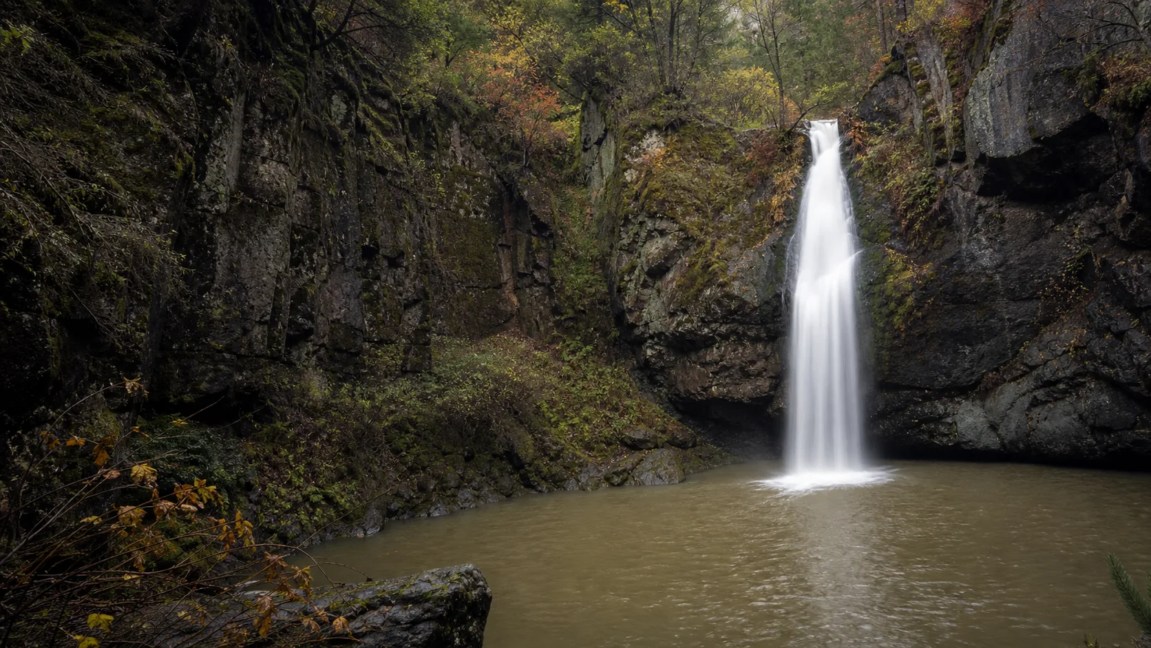
A 164-foot single-plunge over the Lovejoy Basalt plateau above Oroville, reached by a 3-mile out-and-back through North Table Mountain Ecological Reserve's wildflower meadows. Runs hard March through April after a wet winter; usually dry by May. Free CDFW reserve, no dogs, no swimming.
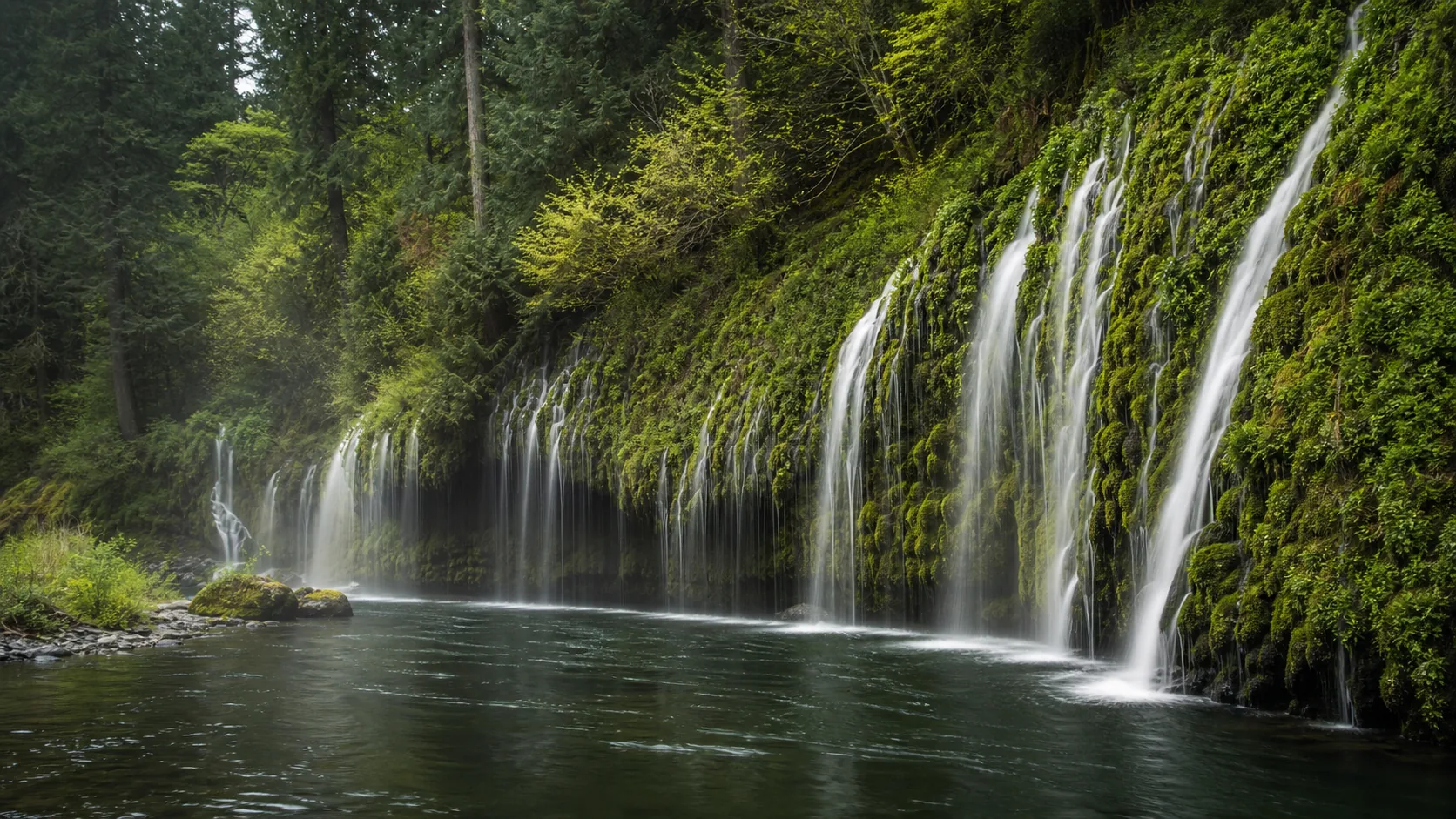
A 70-foot Western Cascades basalt plunge into a teal pool an hour east of Redding off CA-299 and 8 miles of Fenders Ferry Road dirt. Short 0.4-mile walk from the trailhead, free, year-round flow with the loudest curtain in April and the warmest swimming July through September.
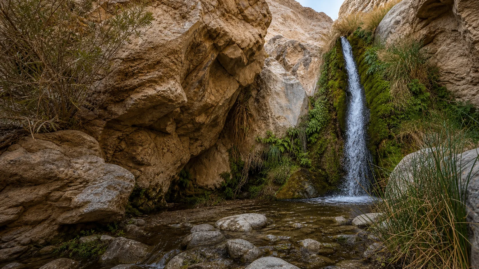
An 80-foot multi-tier spring-fed waterfall hidden in a willow-lined canyon on the western edge of Death Valley National Park. The 2-mile out-and-back from the dirt-road trailhead off CA-190 finds running water, ferns, and tree frogs in the driest national park in the country. $30 park entry; no dogs, no swimming.
California waterfalls run on four separate clocks, and the central question for any trip is whether the specific falls you want is fed by snowmelt, wet-weather runoff, or a constant spring. Wet-weather Sierra foothills falls like Phantom run hard only March through April after a wet winter, and are typically dry by Memorial Day; that window is non-negotiable. Spring-fed Shasta Cascade falls like Mossbrae and the unpublished Burney run at near-constant flow year-round because their water emerges from a basalt aquifer with a multi-decade residence time rather than from seasonal runoff. Western Cascades creek falls like Potem peak in April with snowmelt but hold a respectable curtain through summer, and add a swimming season from late May through September when the pool warms up. Desert spring falls like Darwin are best November through March when Death Valley temperatures stay walkable, with the spring itself running at its steady year-round rate.
The unpublished California icons follow their own clocks worth knowing about. Yosemite Valley waterfalls (Yosemite Falls, Bridalveil, Vernal, Nevada) peak May through early June with snowmelt and Yosemite Falls typically goes dry by August in average water years. McWay Falls on the Big Sur coast runs year-round but is a roadside overlook, not a hike; check Caltrans for Highway 1 closures, which have been frequent since 2017. McArthur-Burney Falls, like Mossbrae, runs constant year-round.
The Shasta Cascade region between Redding and Mount Shasta holds the densest cluster of legal and accessible California waterfalls outside Yosemite. Both published falls in this cluster sit on Western Cascade volcanic rock with springs in the system: Mossbrae is pure groundwater discharge from a basalt aquifer, and Potem Creek runs over a basalt-rim plunge into a deep pool. The unpublished anchors of this region are McArthur-Burney Falls (60 miles east of Mossbrae) and the McCloud River three-tier complex (20 miles southeast of Mount Shasta on SR-89); pair either with a Shasta Cascade trip.
North Table Mountain Ecological Reserve sits on the Lovejoy Basalt plateau above Oroville and Lake Oroville Dam, a 17-million-year-old flood basalt that produces vertical plunges where intermittent meadow streams roll off the rim. The waterfalls only exist as waterfalls in March and April after a wet winter; the rest of the year they are dry rock with wildflower meadows. Hollow Falls, Beatson Hollow, and the named small falls along the plateau are typically visited together with Phantom on the same loop.
Darwin Falls is one of only a handful of year-round water sources inside Death Valley National Park's 3.4 million acres, and the only one that drops as a recognizable waterfall reachable on a day hike. The geology is unrelated to the rest of the California waterfalls on this hub: Inyo Range granitic and metasedimentary bedrock with a permanent fracture-flow spring. The closest base is Panamint Springs Resort on CA-190, the only services on Death Valley's far west side.
California has more than 1,400 named waterfalls per the Northwest Waterfall Survey, the largest count of any U.S. state. The highest concentration is in Yosemite National Park (Yosemite Falls, Bridalveil, Vernal, Nevada, and a dozen others in the valley alone), with secondary clusters in the Shasta Cascade region around Burney and Mount Shasta, in the southern Sierra around Sequoia and Kings Canyon, and along the Big Sur and Northern Coast. This hub covers four published trips so far; the household-name falls (Yosemite, Burney, McWay, Bridalveil) are not yet in our library.
Yosemite Falls, at 2,425 feet across three tiers (1,430-foot upper drop, 675 feet of middle cascades, and a 320-foot lower drop), is the tallest waterfall in California and the tallest in North America. It is fed by Yosemite Creek snowmelt and typically peaks in May with full flow, then thins through summer and often runs dry by August in average water years. Several Sierra Nevada and Big Sur falls are taller in single drops by some measurement methods, but Yosemite Falls is the accepted headline figure.
It depends entirely on what type of waterfall you want. For Yosemite's snowmelt falls (Yosemite Falls, Bridalveil, Vernal, Nevada), plan May through early June when the snowpack is releasing. For the Sierra foothills wet-weather falls like Phantom above Oroville, plan March through April after a wet winter and accept the falls may be dry by May. For year-round spring-fed falls like Darwin in Death Valley, Mossbrae near Dunsmuir, and the unpublished Burney Falls 60 miles east of Mossbrae, the calendar is open year-round and the choice is driven by temperature and crowds rather than flow. Death Valley's window is November through March; the Shasta Cascade window is broadly April through October.
No. The popular 1.5-mile route along the Union Pacific Railroad tracks from Hedge Creek Falls in Dunsmuir is trespass on an active mainline, and visitors are routinely cited. The City of Dunsmuir's own Mossbrae Falls Trail page openly states there is no legal public footpath. Legal access is limited to two paths: a half-day raft or kayak trip on the upper Sacramento River with a Mount Shasta or Dunsmuir outfitter (typically $100 to $200 per person), or invitation through a homeowner in the private Shasta Retreat community on the west bank. A proposed legal pedestrian bridge has been on regional planning documents since the late 2000s but is not built as of May 2026.
Most state and federal waterfalls have either no fee or a vehicle-based park fee. Potem Falls (Shasta-Trinity National Forest) and Phantom Falls (CDFW's North Table Mountain Ecological Reserve) are free to visit. Darwin Falls requires the $30 Death Valley National Park vehicle entrance fee, valid 7 days. Yosemite and Sequoia/Kings Canyon charge $35 per vehicle for 7 days; both are covered by the America the Beautiful federal pass. Mossbrae Falls has no entry fee because there is no legal public access point; the only legal options are a paid guided raft trip or a private invitation.
Potem Falls in Shasta County is the strongest swim hole among our four published California falls; the teal pool below the 70-foot plunge is the destination for most summer visitors, with the warmest water from late May through September. Phantom Falls has no safe pool at the base (the plunge ends on basalt rubble at the top of a steep gully), Darwin Falls is the drinking-water source for Panamint Springs Resort and swimming is prohibited, and Mossbrae's Sacramento River pool is cold, fast, and surrounded by private property or rail right-of-way. The unpublished classic California waterfall swim is Salmon Creek Falls in south Big Sur, with a deep pool at the base of a 120-foot drop a short walk from Highway 1.
The state has the right combination of three factors: heavy precipitation across the Sierra Nevada and Klamath Mountains (the Sierra holds the largest snowpack in the lower 48 states in normal years), an active and varied geology of granitic Sierra batholiths, Western Cascade and Modoc Plateau volcanics, and Lovejoy Basalt flows that produce vertical rock steps, and an enormous range of elevation and climate from sea level on the Big Sur coast to the 14,505-foot Mount Whitney summit. The combination produces snowmelt falls (Yosemite), spring-fed falls (Burney, Mossbrae, Darwin), wet-weather plateau falls (Phantom and the rest of North Table Mountain), and tidewater falls (McWay).
Plan Darwin Falls in Inyo County, California: 2 mi route details, parking and directions, best time to visit, safety notes, and 8 waterfall photos.
Plan Mossbrae Falls in Siskiyou County, California with waterfall photos, map context, parking checks, directions, access notes, and best-time guidance.
Plan Phantom Falls near Oroville, California: 3 mi route details, parking and directions, best time to visit, safety notes, and 4 waterfall photos.
Plan Potem Falls in Shasta County, California: 0.4 mi route details, parking and directions, best time to visit, safety notes, and 4 waterfall photos.