Potem Falls 70-foot plunge into the teal swimming hole on Potem Creek
Shasta County, CA

Potem Falls

Potem Falls is a 70-foot single-tier plunge on Potem Creek that drops over Western Cascades basalt into a deep teal swimming hole, deep in the Shasta-Trinity National Forest between Redding and Burney. A short 0.4-mile trail off Fenders Ferry Road delivers you to the pool itself, which is the main reason most visitors come: from late May through September it is one of the best wild swimming holes in Northern California.

Last verified May 12, 2026 Visited Desk-verified May 2026 7 sources checked
Trail 0.4 mi 0.6 mi extended
Time 15-45 min Easy
Best season Late May through September for swimming; April for the loudest flow April after snowmelt
Parking Free dirt pullout at the trailhead on Fenders Ferry Road; high-clearance vehicle recommended for the final 8 miles Shasta-Trinity National Forest
Quick answer

Is Potem Falls worth visiting?

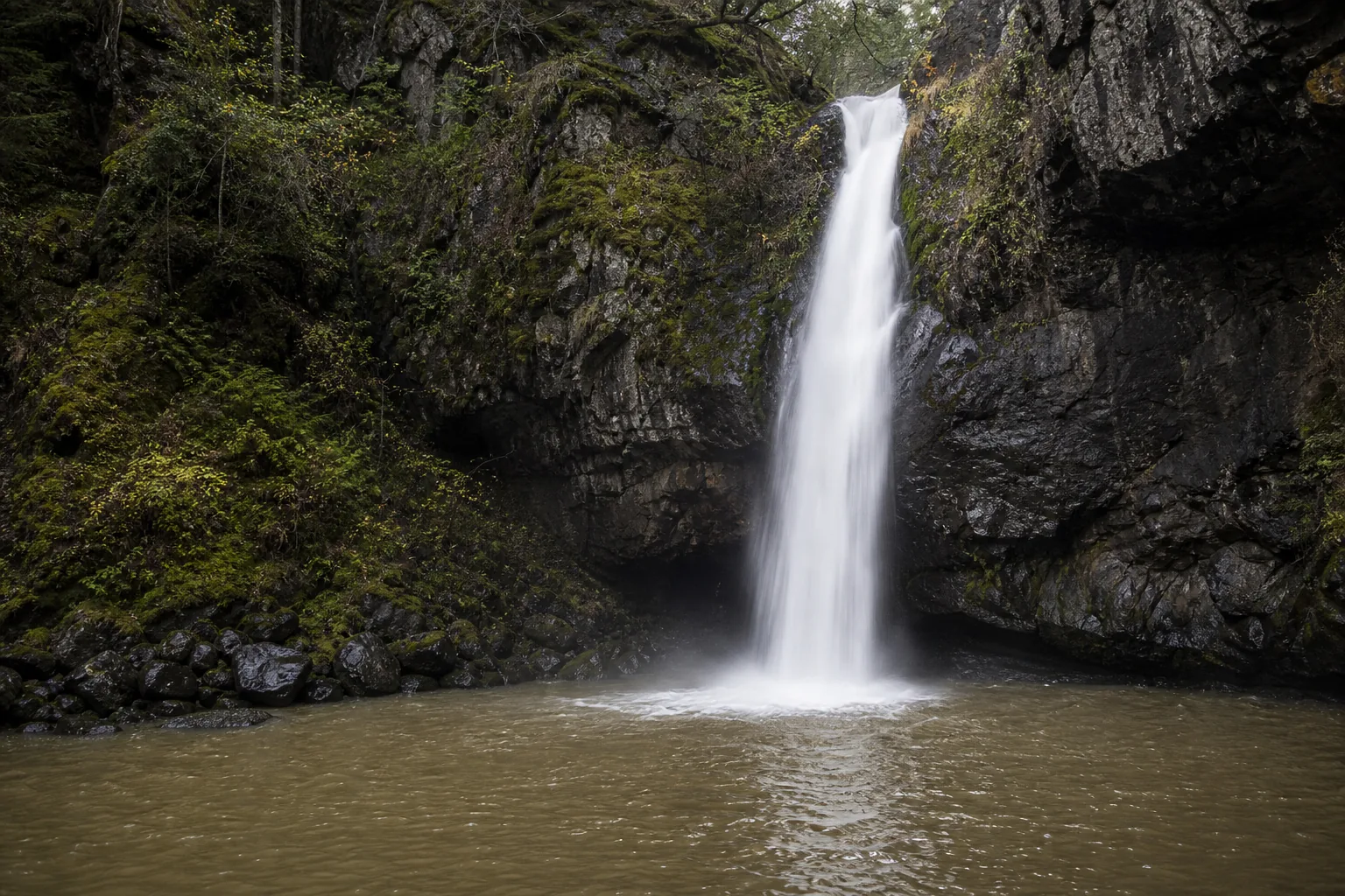
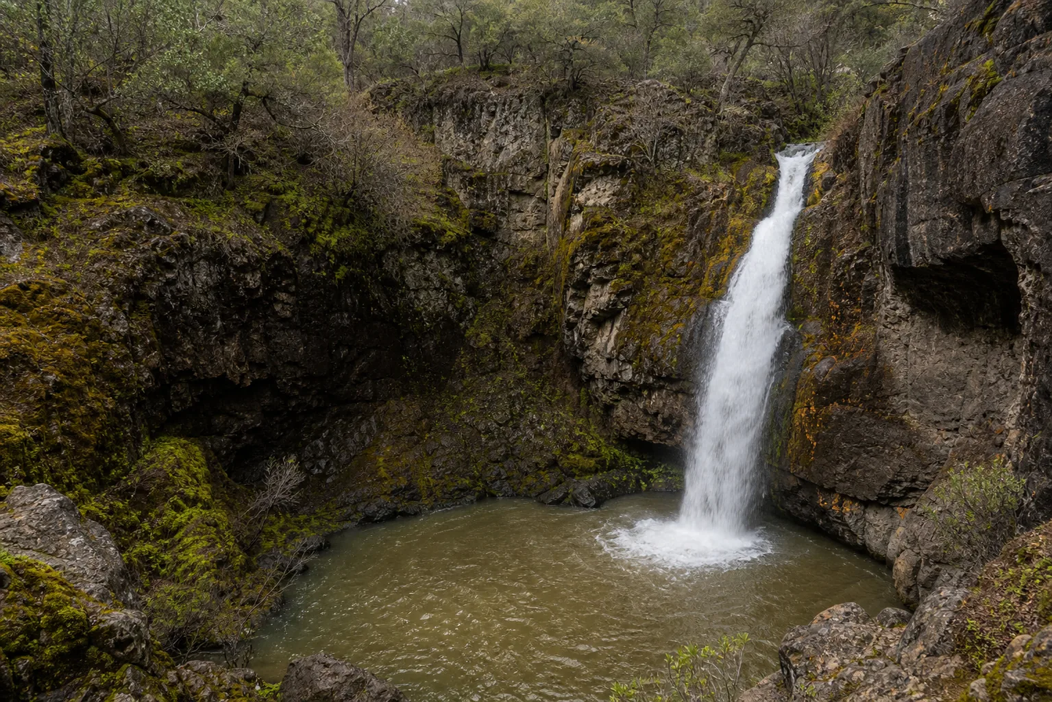
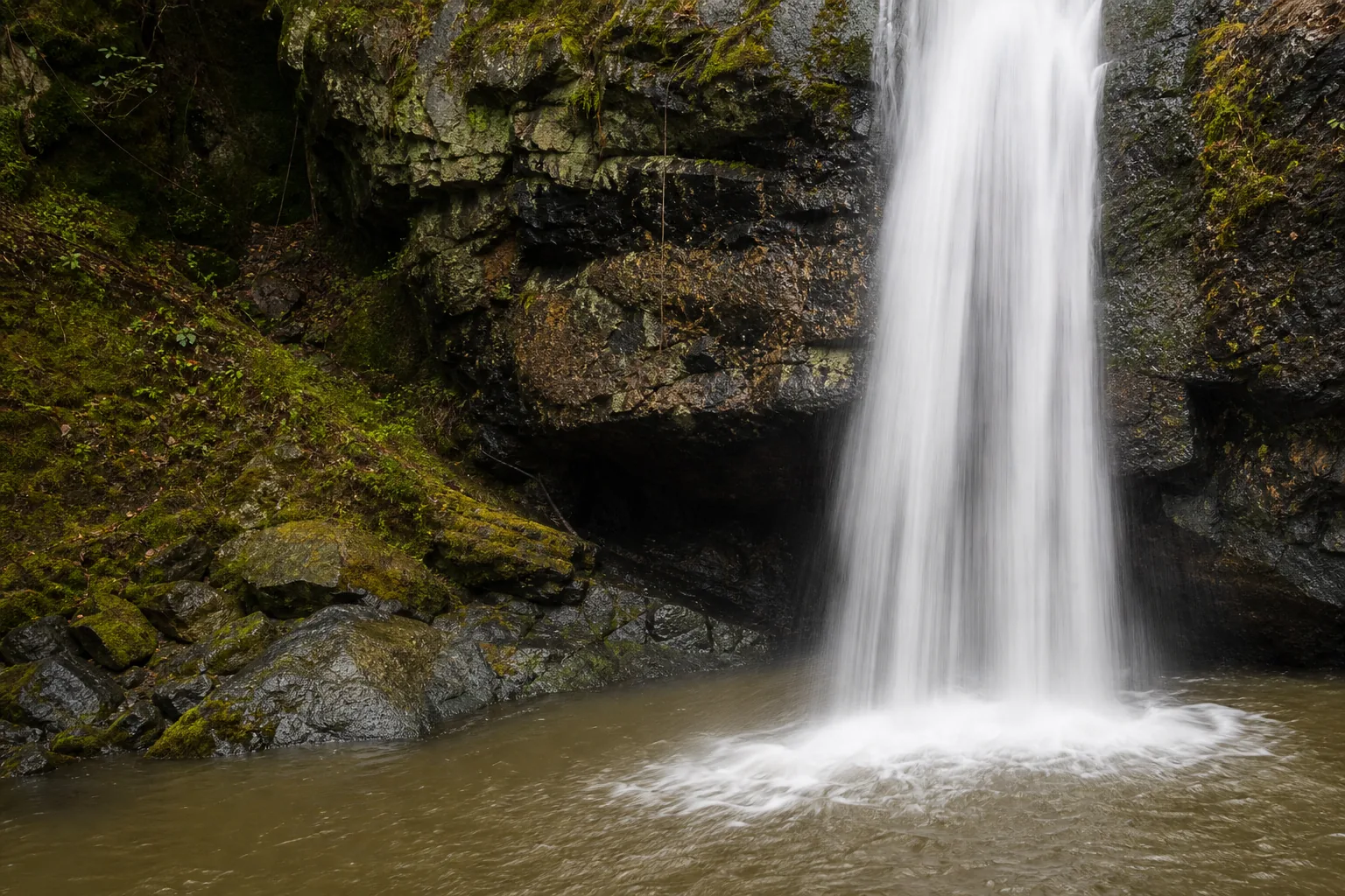
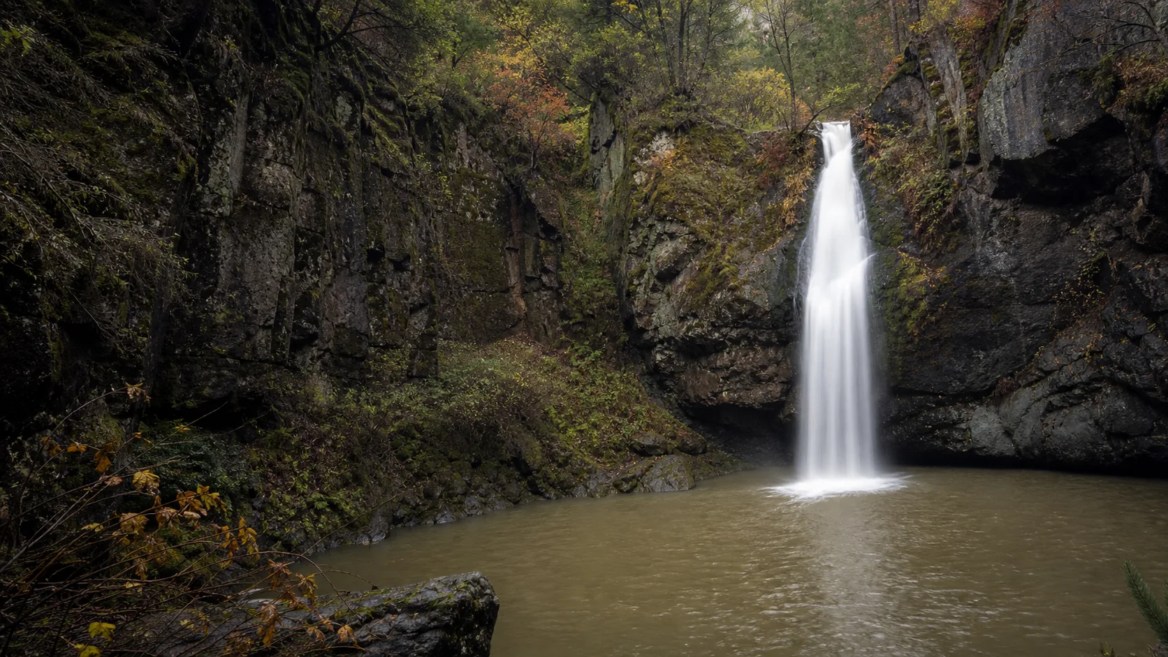
Yes, especially between late May and September if you want a wild swimming hole rather than just a roadside overlook. Potem is a single 70-foot plunge into a teal, deep pool reached by a short 0.4-mile trail; the harder part of the trip is the 8-mile dirt drive on Fenders Ferry Road, where a high-clearance vehicle is recommended. The water stays cold (50s to low 60s F) even in August, the pool is deep enough to swim, and there are no fees, no permits, and no crowds outside summer weekends.

  • 70-foot single-tier plunge over basalt
  • Short 0.4-mile trail to the pool
  • Free, no permit, no entry fee
  • Best swim window: late May to September
  • 8 miles of dirt road on Fenders Ferry; high clearance recommended
  • Pairs with Burney Falls and Shasta Lake for a Redding-area waterfall day
Last verified May 12, 2026 Visited Desk-verified May 2026 7 sources checked
Distance 0.4 mi 0.6 mi extended
Round trip 15-45 min Short trail; dirt road approach is the harder part
Difficulty Easy Short trail; dirt road approach is the harder part
Location Shasta County, CA Shasta-Trinity National Forest
Parking Free dirt pullout at the trailhead on Fenders Ferry Road; high-clearance vehicle recommended for the final 8 miles USFS
Transit No fixed-route transit Drive only; nearest highway is CA-299 at Montgomery Creek · 0 ft
Drive 35 mi 60 min from downtown
Best season Late May through September for swimming; April for the loudest flow April after snowmelt
Potem Falls base of the falls and the spray line where summer swimmers stage
Photo guide

Three working positions for a 70-foot single-tier plunge.

Potem rewards three frames: the wide pool-edge shot opposite the falls (the canonical brochure view), the angled approach from the trail descent showing cliff and canopy together, and a close detail at the base where the curtain hits the teal water. Late-morning light on a clear day is when the pool color reads strongest.

Potem Falls 70-foot plunge into the teal swimming hole on Potem Creek
Potem Falls, hero composition
Wide view of Potem Falls dropping 70 feet over basalt into a teal swimming hole
The 70-foot single-tier plunge and the teal pool from across the creek
Base of Potem Falls and the swimming-hole spray line
Base of the falls and the spray line where summer swimmers stage
Close detail of Potem Falls water hitting basalt at the plunge pool
Water-and-basalt detail at the lip of the plunge
01Is Potem Falls flowing right now?

Potem Falls is intentionally not paired with a live USGS gauge because Potem Creek is small, ungauged, and the swimming-hole experience does not depend on flow numbers the way a runoff-fed cataract does.

Potem Creek is small and ungauged, so flow estimates are seasonal rather than real-time. Expect the loudest curtain in April after snowmelt, comfortable summer swim conditions from late May through September, and a noticeably thinner curtain by October. The pool itself is spring-fed enough to hold water year-round even when surface flow drops.

02How long is the walk?

The trail is 0.4 miles round trip with about 80 feet of elevation loss to the pool, on a rooty dirt path that gets steeper near the bottom. Plan 15 to 30 minutes for the walk itself; most visitors spend two to four hours at the pool in summer.

03How do you get there?

From Redding, take CA-299 East roughly 35 miles to Montgomery Creek. Watch for Fenders Ferry Road on the left (north side). Take Fenders Ferry 3.5 miles on pavement, then continue about 8 miles on dirt road; the trailhead is an unmarked pullout on the right after the road bends east. The Forest Service recommends a high-clearance or four-wheel-drive vehicle for the dirt section. From Burney, drive CA-299 west about 25 miles to the same Fenders Ferry Road turnoff.

04Is there free parking?

Free dirt pullout at the trailhead on Fenders Ferry Road; no built lot, no fee, no pass required. Space is limited (maybe 6 to 10 vehicles) and fills on summer weekends; arrive early. Do not block the road.

05Does it cost money?

Free. No entry fee, no parking fee, no Adventure Pass required for the Potem Falls trailhead. The cost is the drive and the vehicle wear on the dirt road.

06Trail variants

Standard trailhead to falls 0.4 mi round trip, 15-30 min, from the Fenders Ferry Road pullout.
Swimming-hole day 0.4 mi round trip, 2-4 hr at the pool, bring water shoes; the pool floor is rock and gravel.
Photographers' early arrival 0.4 mi round trip, 60-90 min, first light gives the teal pool its strongest color.
By boat from Shasta Lake (Pit River arm) varies, half day, beach near the Pit 7 Dam area and bushwhack up the creek.

Detailed maps and recent reviews: Falls route on AllTrails · Creek route on AllTrails

07Can you swim?

Yes. Swimming in the plunge pool is the main reason most visitors come. The pool is deep, cold (50s to low 60s F year-round), and the floor is rock and gravel. Water shoes recommended. Keep clear of directly under the falls when flow is high.

08Are dogs allowed?

Yes. Dogs are allowed on the trail and at the pool; keep them leashed near the cliff edge above the falls and on the short scramble down. Bring water for them; the trail offers little shade on the descent.

09Is it accessible?

The trail is not wheelchair accessible. It is unpaved, rooty, descends roughly 80 feet, and ends on a rocky pool edge with no built overlook.

Field notes

Potem Falls at a glance.

70-foot single-tier plunge on Potem Creek, over Western Cascades volcanic basalt, in Shasta-Trinity National Forest, Shasta County, California. Free to visit, short 0.4-mile trail, swim-friendly pool, dogs welcome, 8 miles of dirt road on the approach.

Height 70 ft USGS 3DEP
Type Plunge (single tier) USGS
County Shasta Shasta County, CA
Managed by USDA Forest Service, Shasta-Trinity National Forest USFS
Water source Potem Creek USGS
Elevation 1306 ft USGS NED
Park area 2,100,000 acres USFS
Hours Trail open 24 hours; Fenders Ferry Road may be limited in winter weather USFS
When to visit

Late May through September is the swim window; April is the loudest curtain.

The defining decision is whether you want the swimming hole or the loud falls. Late May through September delivers warm air, manageable creek flow, and a pool you can actually swim in. April produces the loudest plunge and the strongest spring color, but the water is too cold for most swimmers and the dirt road may be muddy.

PEAK FLOW

Peak flowApril after snowmelt
Ice / low flowRarely freezes
Most crowdedWeekends and midday
Best photosSunrise or weekdays

Live water context

Discharge data -- Potem Falls is intentionally not paired with a live USGS gauge because Potem Creek is small, ungauged, and the swimming-hole experience does not depend on flow numbers the way a runoff-fed cataract does.

Why is it called Potem Falls?

The origin of the name Potem is uncertain. It survives as a placename on the creek, the falls, and a nearby ridge, but no settled etymology is documented in the standard California placename references; it does not match any obvious Wintu word for the area, and 19th-century mining and homestead records use the spelling without explaining it. The most likely candidate is a 19th-century settler surname tied to a small homestead on the creek above the falls, which is the pattern that produced most other Shasta County creek names in that era. Until a verified primary source surfaces, this guide treats the name as origin uncertain rather than guessing.

What else to do at Shasta-Trinity National Forest

Potem Falls sits inside the Shasta-Trinity National Forest, the largest national forest in California at about 2.1 million acres, managed by the USDA Forest Service. The closest highway is California 299 at Montgomery Creek, between Redding (35 miles west) and Burney (25 miles east). The trailhead is on Fenders Ferry Road, an unmarked spur that drops north from CA-299: roughly 3.5 miles paved, then 8 miles of dirt road. The Forest Service recommends a high-clearance or four-wheel-drive vehicle for the dirt section. There are no fees, no kiosk, no ranger station at the trailhead; the falls is essentially a self-managed swimming hole on public land, which is most of its appeal and most of its risk.

  • The 70-foot plunge. A single-tier vertical drop over Western Cascades basalt into a deep, teal pool roughly 50 feet across; this is the headline.
  • Potem Creek. A small Pit River tributary that drains the southern flank of the Hatchet Mountain area and feeds the Pit 7 arm of Shasta Lake about 6 miles downstream.
  • Fenders Ferry Road approach. The defining feature of the trip; 3.5 miles paved off CA-299, then 8 miles of dirt. High-clearance recommended.
  • Shasta-Trinity National Forest. 2.1 million acres of public land surrounding the trailhead, with adjacent dispersed camping, fishing, and forest-road exploration.
  • Pit River and Shasta Lake. Potem Creek joins the Pit River arm of Lake Shasta downstream; experienced boaters can also reach the falls by beaching near the Pit 7 Dam and walking up the creek.

Why it looks this way

Potem Falls drops over a layer of Western Cascades volcanic basalt, the older volcanic foundation of the southern Cascade Range that predates the High Cascades stratovolcanoes (Mount Shasta, Lassen Peak) by tens of millions of years. The lip is a resistant basalt flow that the creek has been unable to cut through cleanly; instead, the water plunges as a single 70-foot drop and excavates the softer interflow material below into the deep teal pool that defines the site. The teal color is a function of depth plus dissolved minerals plus clean spring-fed water with very little suspended sediment, the same combination that makes other Cascade-fed pools (McCloud Lower Falls, Burney Falls) look the way they do. Potem Creek is small and ungauged, so the flow is highly seasonal: peak in April after snowmelt, comfortable for swimming through summer, low by September.
Field guide deep dive

What the AllTrails listing and the swimming-hole Instagram do not tell you.

How the falls actually formed, what the teal pool is really like to swim in, why the dirt road is the filter, and how Potem fits into a Redding-Shasta-Burney waterfall day.

How Potem Falls formed

Potem Falls sits on the edge of the southern Cascade Range, in a band of older volcanic rock geologists call the Western Cascades. These flows are tens of millions of years older than the High Cascades stratovolcanoes you can see from CA-299 on a clear day (Mount Shasta to the northwest, Lassen Peak to the south). They are the worn-down foundation that the younger volcanoes were stacked on top of, and they form most of the canyon walls along the Pit River and its tributaries.

What you are looking at when you stand at the pool is a resistant basalt flow that Potem Creek has been unable to cut through cleanly. Above the lip, the creek runs through softer interflow material and weathered tuff. At the basalt band, the water has nowhere to go but over the edge as a single 70-foot plunge. Below the lip, the softer rock has been excavated into the deep bowl that holds the teal pool. The geology is doing exactly the same thing here that it does at Burney Falls 25 miles east (resistant basalt over softer underlying material) and at McCloud's Lower Falls 40 miles north. The difference at Potem is the scale: one plunge, one pool, no overlook infrastructure.

The pool color is worth understanding because it is not artistic license. The teal comes from three things together: depth (the pool is genuinely deep at the base of the falls), dissolved minerals from the basalt aquifer feeding Potem Creek, and very low suspended sediment because the creek is small and spring-buffered rather than runoff-flashy. On a clear day around noon, the color reads as a saturated blue-green that holds up in photos without filtering.

The swimming-hole reality: depth, current, cold water, kids

Most Potem visitors come to swim, and the pool delivers, but it is worth understanding what you are walking into before you bring kids or a casual swimmer. The pool is deep at the base of the falls (well over head height in the central bowl) and shallower along the rocky edge where most people stage. The floor is rock and gravel, not sand; water shoes are not optional unless you have leather-soled feet. There is no lifeguard, no posted depth, and no rescue infrastructure within an hour's drive.

The water is cold year-round. Potem Creek is spring-fed and the pool sits in deep shade for most of the day, so even in August the temperature stays in the 50s to low 60s Fahrenheit. That is brisk for adults and genuinely uncomfortable for small kids unless they are acclimated. Plan on short swim sessions, not a full afternoon in the water.

The current is mostly contained inside the plunge bowl. Stay back from directly under the falls when flow is high (April through early June in a wet year): the hydraulic at the base of a 70-foot plunge can recirculate a swimmer, and falling debris from the cliff is a real if uncommon risk. Most summer visitors stage on the rock shelf opposite the falls, swim across the bowl in calm conditions, and use the falls itself as a backdrop rather than a destination. That is the right plan with kids and the right plan in general.

The 0.4-mile trail and the Fenders Ferry Road approach

The trail itself is short and not the hard part: about 0.4 miles round trip, dropping roughly 80 feet from the dirt pullout to the pool edge on a rooty dirt path that steepens near the bottom. Trail running shoes are fine in dry weather; in mud, sticky-soled hikers will be happier. Plan 15 to 30 minutes for the walk and another two to four hours at the pool if you are swimming.

The hard part is Fenders Ferry Road. From CA-299 at Montgomery Creek, you turn north and drive 3.5 miles of pavement, then continue another 8 miles on a dirt forest road. The Shasta-Trinity National Forest trail page explicitly recommends a high-clearance or four-wheel-drive vehicle. In dry summer conditions a careful driver in a low-clearance car can usually make it (slowly), but the road has rough sections, occasional washouts, and after rain it can be slick or rutted. The bridge crossings are narrow with strong canyon views; not a problem unless you dislike one-lane bridges over creek gorges.

The road is the filter that keeps Potem from being overrun. Compare it to Burney Falls, where a state-park paved approach delivers tour buses; Potem's dirt road thins the crowd to people who are willing to put miles on a rental car's tires. That is most of why it stays photogenic.

Potem vs Burney Falls: how they actually compare

Potem and Burney Falls get compared constantly because they sit 25 miles apart on the same CA-299 corridor and look photogenic from the same angle on Instagram. They are not the same trip. Burney is a 129-foot multi-source spring complex inside McArthur-Burney Falls Memorial State Park: paved access, $10 day-use fee, formal overlook, built trails, picnic areas, a campground, ranger station, and an estimated 100 million gallons per day of constant spring discharge that does not vary with the season. It is a state-park destination experience.

Potem is a 70-foot single-tier plunge with a dirt road, a 0.4-mile trail, no fee, no infrastructure, and a swimming hole at the bottom that you can actually use. Flow is seasonal rather than constant; the falls is photogenic year-round but the swim window is roughly late May through September. The cliff is darker, the pool color is more saturated, and the experience is solitary in a way Burney has not been for 30 years.

The honest answer if you have one day: visit both. Drive CA-299 east from Redding, hit Potem in the morning when the dirt road is cooler and the pool gets clean overhead light, then continue 25 miles east to Burney for the afternoon. They reward different things. Potem is for the swim and the solitude; Burney is for the scale and the geology demonstration. We have a dedicated Burney Falls guide planned but not yet published; for now, the Mossbrae Falls geology comparison in our Mossbrae guide covers the related spring-and-basalt mechanic that Burney also displays.

A Redding to Shasta Lake to Burney waterfall day

Redding is the natural base for a Potem trip. From downtown Redding, take CA-299 East about 35 miles to Montgomery Creek, then north on Fenders Ferry Road to the trailhead. Total drive: roughly 60 minutes plus the dirt-road segment, call it 75 to 90 minutes door to trailhead. Redding Municipal Airport (RDD) is similar (about 70 minutes). Most visitors do Potem as a 4 to 6-hour outing including the drive both ways.

The day-trip version that pays off the gas: start in Redding by 8 a.m., drive to Potem and arrive by 9:30 a.m. before the pool fills with swimmers. Spend two to three hours at the pool. Drive back to CA-299 and head 6 miles west to the Pit River arm of Shasta Lake for a midday lunch stop and a boat-launch view of the lower Pit canyon. Then continue east on CA-299 to McArthur-Burney Falls Memorial State Park for the afternoon, watching the contrast between Potem's small ungauged creek and Burney's constant 100-million-gallon-per-day spring complex. Loop back to Redding via CA-299 west; total mileage roughly 150 miles, total time about 9 hours including stops.

If you have two days, add the McCloud River three-tier complex (Lower, Middle, Upper Falls) 40 miles north of Burney along CA-89, which adds another set of basalt-over-softer-rock plunges with a swimming hole at Lower Falls that is comparable to Potem's. That is the canonical Shasta Cascade waterfalls weekend, and Potem earns its place on it.

Photographing the teal pool (light, exposure, position)

The Potem fan is small enough that there are really three frames that pay off the dirt-road approach. The canonical wide shot is from the rocky pool edge opposite the falls, low to the water, with the full 70-foot plunge centered and a slice of the cliff and canopy framing the top. Aspect ratio matters here: vertical orientation captures the full drop and the pool together, while horizontal compresses the cliff. Most published Potem photographs are vertical.

The angled descent frame is from the last 30 feet of the trail before the pool, where the cliff opens up and you can shoot down at the curtain with the canopy still in the top of the frame. This is the shot that shows the relationship between the forest above and the basalt drop below; it reads as more atmospheric and less postcard than the pool-level wide shot.

The close detail frame is at the base of the falls, where the curtain hits the teal pool. Shoot tight enough to crop out the cliff and the canopy and let the water-on-water texture carry the image. Long exposures (1 to 2 seconds) collapse the plunge into a smooth ribbon; faster shutter speeds (1/250 or faster) freeze the texture and the spray.

For the pool color, plan for late morning through early afternoon on a clear day. The site faces roughly southwest, so the cliff is in shadow until late morning and the pool needs overhead sun to read as saturated teal rather than dark green. Soft overcast is the most forgiving for the cliff face but tends to mute the pool color; on cloudy days, shoot the curtain and the cliff and skip the pool wide shot.

Map and route

An hour from Redding, deep in the Shasta-Trinity National Forest.

From Redding, take CA-299 East roughly 35 miles to Montgomery Creek. Watch for Fenders Ferry Road on the left (north side). Take Fenders Ferry 3.5 miles on pavement, then continue about 8 miles on dirt road; the trailhead is an unmarked pullout on the right after the road bends east. The Forest Service recommends a high-clearance or four-wheel-drive vehicle for the dirt section. From Burney, drive CA-299 west about 25 miles to the same Fenders Ferry Road turnoff.

Photography and weddings

Southwest-facing cliff, late-morning sun for the teal pool color.

Potem rewards photographers who plan around two things: the teal pool color, which needs overhead light to read true, and the contrast between the dark basalt cliff and the bright single-tier curtain, which needs soft light to hold detail at both ends. The three working positions are the pool edge directly opposite the falls (the canonical wide shot), the angled approach from the trail descent (cliff-and-canopy frame), and a close water-and-rock detail near the base. The site faces roughly southwest, so afternoon sun lands on the cliff and morning shade keeps the spray cool.

Late morning through early afternoon on a clear day gives the strongest teal color in the pool because overhead sun penetrates deeper and the water reads as a saturated blue-green rather than a dark mirror. Soft overcast is the most forgiving for the cliff and curtain. Sunrise and sunset light is filtered through dense canopy and tends to read flat rather than dramatic at this site. Long exposures (1 to 2 seconds) collapse the plunge into a smooth ribbon; faster shutter speeds (1/250) freeze the texture if you want the spray detail.

Personal photography from public viewpoints does not require a permit. Drone use over the swimming hole is discouraged because it disturbs swimmers; check current Shasta-Trinity National Forest and FAA rules before flying. Commercial shoots and large-group portrait sessions require Forest Service approval.

Permits

Weddings and engagements

Potem is occasionally used for engagement and elopement portraits in shoulder season when crowds are thin, but it is not a venue and there is no ceremony infrastructure.

Any commercial portrait session or organized ceremony on national forest land requires a Shasta-Trinity special-use permit; check with the Hayfork or Mountain Top Ranger District before scheduling.

Plan around the dirt road, the lack of restrooms, and the fact that the pool will likely have swimmers in it during peak season. McArthur-Burney Falls Memorial State Park, 25 miles east, is the more formal nearby option for ceremonies.

Nearby waterfalls

A Redding to Burney waterfall day with Shasta Lake in the middle.

Potem pairs naturally with Burney Falls 25 miles east at McArthur-Burney Falls Memorial State Park and with Shasta Lake to the west. The full day is reasonable from Redding: Potem in the morning, Shasta Lake or the Pit River arm at midday, and Burney Falls in the afternoon.

Related questions

More questions visitors ask before driving to Potem Falls.

Height, distance, swim, dogs, fees, location, season, and the worth-it answer. The full set is also indexed in the FAQ schema for AI answer engines.

01How tall is Potem Falls?

Potem Falls is 70 feet tall, a single-tier vertical plunge on Potem Creek over a band of Western Cascades volcanic basalt. The AllTrails listing rounds it to 69 feet; the Shasta-Trinity National Forest trail page and the most-cited trip reports use 70 feet.

02Is Potem Falls free?

Yes. There is no entry fee, no parking fee, and no Adventure Pass requirement at the Potem Falls trailhead. The trail is on Shasta-Trinity National Forest land and is free to use; the cost is the dirt-road drive and the vehicle wear.

03Where is Potem Falls?

Potem Falls is in Shasta County, California, inside Shasta-Trinity National Forest, on Potem Creek near Montgomery Creek between Redding and Burney. From Redding, take CA-299 East 35 miles to Montgomery Creek, then north on Fenders Ferry Road (3.5 miles paved, then 8 miles of dirt) to the trailhead.

04What is the best time to visit Potem Falls?

The best swim window is late May through September, when air temperatures are warm and creek flow is manageable. April produces the loudest curtain after snowmelt but the water is too cold for most swimmers. Avoid winter unless you have called the Forest Service and confirmed Fenders Ferry Road is passable.

05Is Potem Falls worth visiting?

Yes, especially in summer if you want a wild swimming hole rather than a roadside overlook. The 70-foot single-tier plunge, the teal pool, the short trail, and the lack of crowds outside summer weekends make it one of the best swim-friendly waterfalls in Northern California. The dirt-road approach is the filter; the pool is the payoff.

Sources and data

Where the Potem Falls guide gets its facts.

Shasta-Trinity National Forest trail page, AllTrails listing and reviews, Yelp local visitor notes, regional trip-report blogs, Sierra Nevada Geotourism entry, NorthwestWaterfalls.com hydrologic context, Wikimedia Commons for photo provenance, and USGS regional geology for the Western Cascades volcanic stratigraphy.

USFS: Shasta-Trinity National Forest fs.usda.gov
Access, parking, and permit rules: fs.usda.gov
USGS regional geology: Western Cascades volcanic stratigraphy: Shasta County bedrock usgs.gov
NOAA/NWS forecast grid STO/43,172 noaa.gov
USGS National Elevation Dataset 3DEP
Google Maps: embedded map and directions maps.google.com
Google Places: nearby restaurants and hotels places API
Shasta-Trinity National Forest: Potem Falls Trail fs.usda.gov
AllTrails: Potem Falls Trail (current reviews and conditions) alltrails.com
Wikimedia Commons: Potem Falls image category commons.wikimedia.org
Sierra Nevada Geotourism: Potem Falls entry sierranevadageotourism.org
Northern California Hiking Trails: Potem Falls Trail trip report northerncaliforniahikingtrails.com
NorthwestWaterfalls.com: Potem Falls northwestwaterfalls.com
California Through My Lens: Potem Creek Falls californiathroughmylens.com
NOAA/NWS forecast grid weather.gov
Fact checks
Height audit: 70 feet matches the Shasta-Trinity National Forest trail page and the most-cited trip reports; AllTrails uses 69 feet. The 60-foot figure on some older blogs is an undercount.
Trail audit: 0.4 mi round trip with roughly 80 ft elevation loss matches the Forest Service trail description (0.3 mi one-way) and AllTrails current reviews.
Approach audit: Fenders Ferry Road is 3.5 mi paved + 8 mi dirt from CA-299; the Forest Service explicitly recommends a four-wheel drive or high-clearance vehicle.
Swim audit: swimming is widely documented in trip reports and tolerated on Forest Service land; the page does not promise lifeguard or rescue services and flags the year-round cold water plus hydraulic risk under the falls in high flow.
Geology audit: Western Cascades volcanic basalt label is consistent with USGS regional stratigraphy for the southern Cascades east of Redding.
Etymology audit: name origin is treated as uncertain because no settled etymology is documented in the standard California placename references.
Corrections: [email protected]