Zapata Falls waterfall and surrounding setting
Alamosa County, CO

Zapata Falls

Zapata Falls is a 30-foot waterfall hidden inside a slot canyon at the western edge of the Sangre de Cristo Range, reached only by wading ankle-to-knee-deep up South Zapata Creek through the slot itself. It sits on BLM land about 5 miles south of Great Sand Dunes National Park, which makes it one of the most efficient half-day pairings in southern Colorado: dunes in the morning, slot-canyon waterfall in the afternoon.

Last verified May 12, 2026 Visited Desk-verified May 2026 6 sources checked
Trail 0.8 mi Round-trip route varies
Time 30-90 min Easy to moderate with a cold, slippery creek wade at the end
Best season Late June through early September for warm weather and the summer wade; mid-January through mid-February for the frozen ice cone inside the slot After rain or snowmelt
Parking BLM trailhead lot, $5 per vehicle day-use fee, fills on weekends Zapata Falls Special Recreation Management Area
Quick answer

Is Zapata Falls worth visiting?

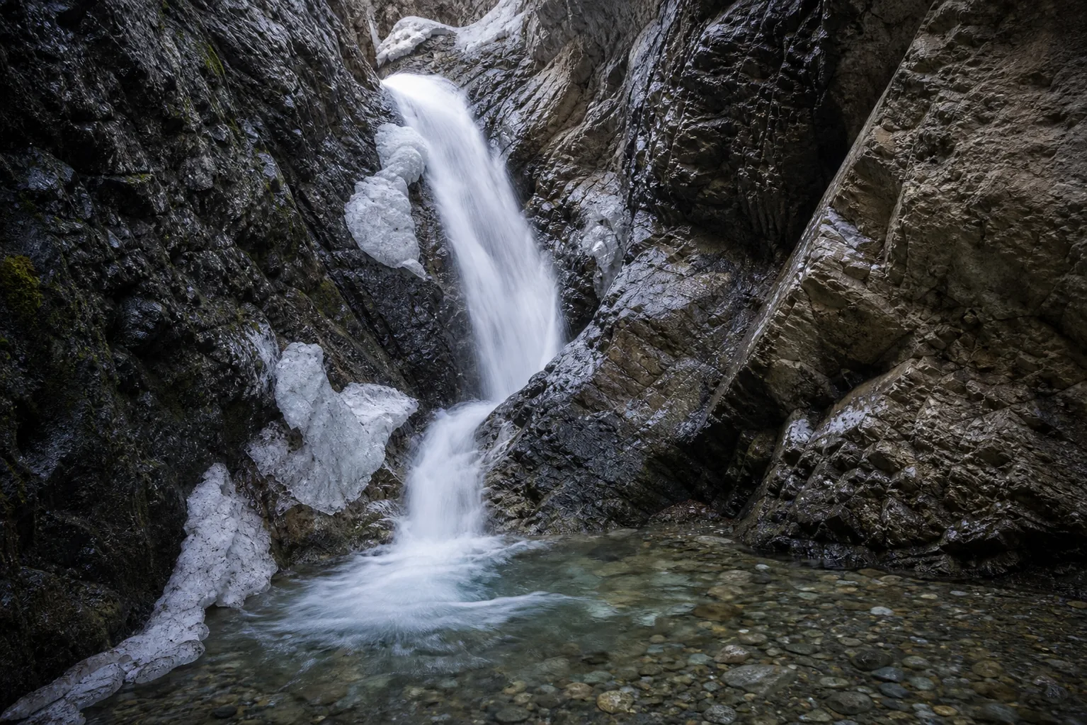
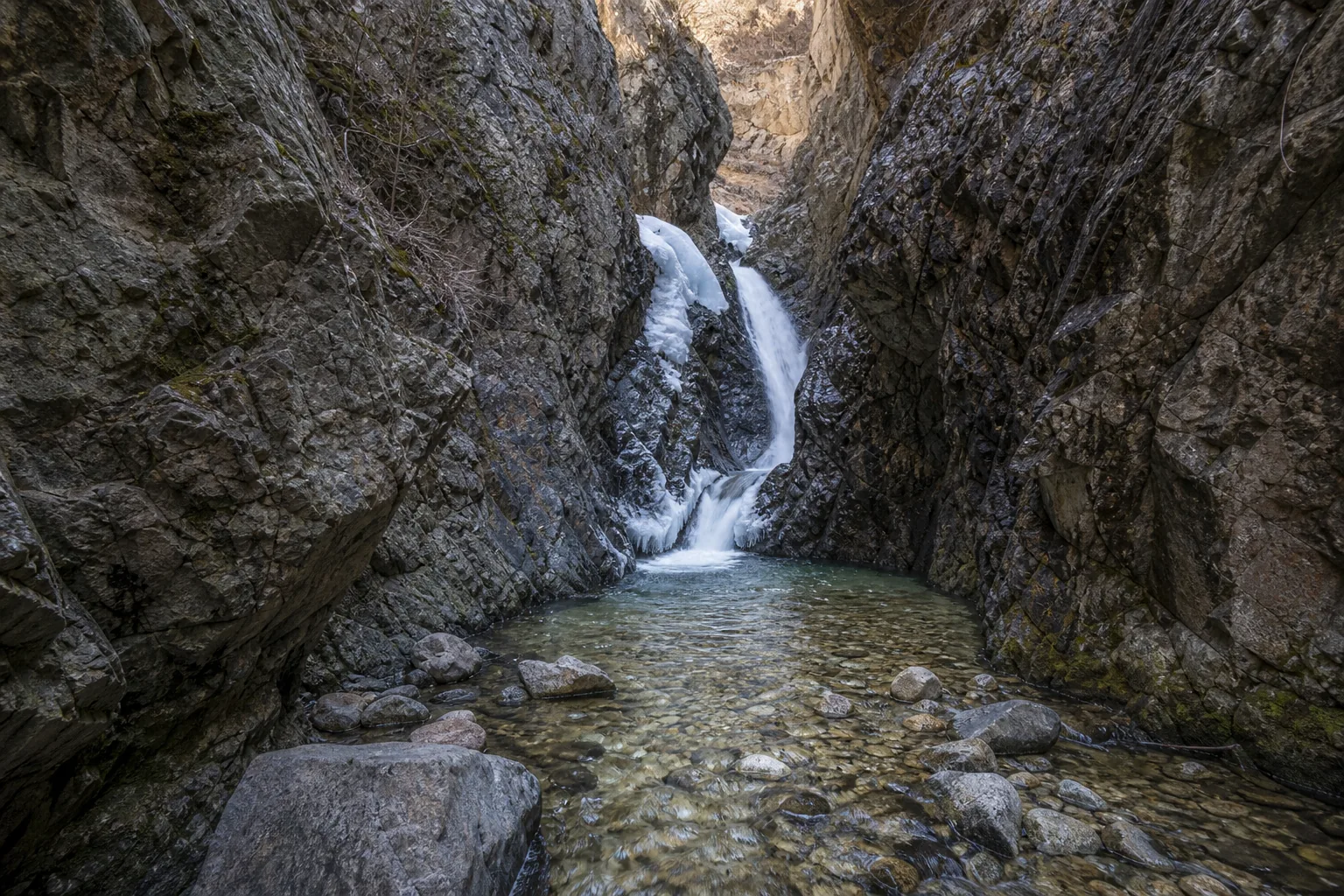
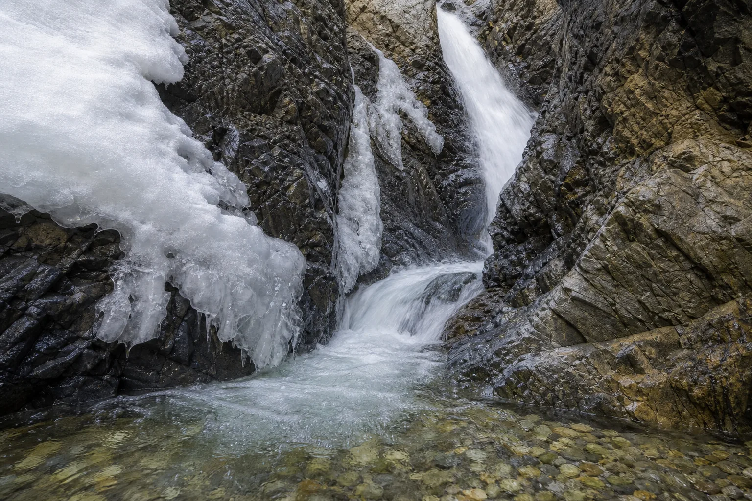
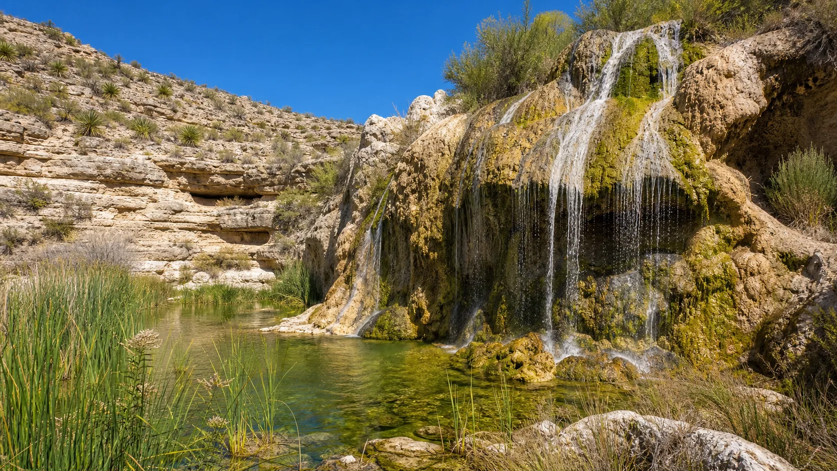
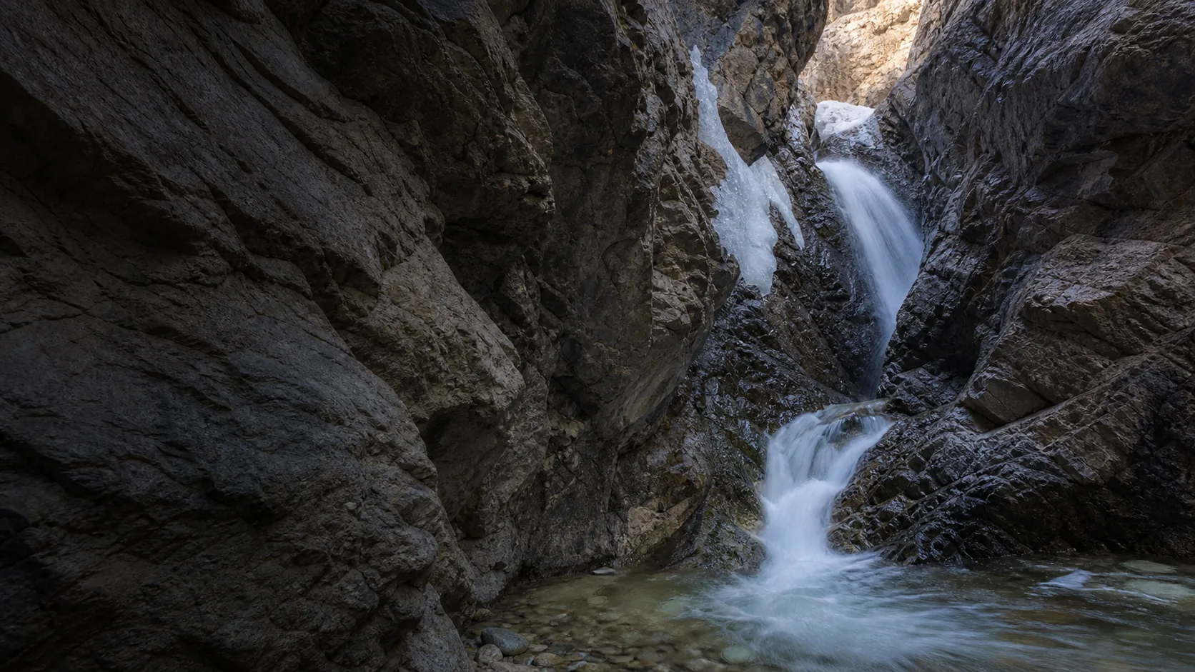
Yes, in two very different windows. June through early September is the wading window, when warm air makes the snowmelt-cold creek tolerable and the 30-foot falls runs full inside the slot; January through February is the ice-climbing window, when the same slot freezes into a vertical blue ice cone. The hike itself is short (0.8 mi round trip from the trailhead with about 200 ft of climb), and the BLM site charges a $5 per-vehicle day-use fee. Budget an extra 20 to 30 minutes for the 3.6-mile rough gravel access road off CO-150.

  • 0.8-mile round trip from BLM trailhead off CO-150
  • $5 per-vehicle BLM day-use fee at the trailhead
  • Last quarter mile is a wade up the creek inside a slot canyon
  • Trailhead near 9,000 ft; falls drop about 30 ft (BLM); roughly 200 ft climb on trail
  • 5 mi south of Great Sand Dunes National Park entrance
  • 3.6-mile rough gravel access road; passenger cars OK in dry summer, high clearance preferred
Last verified May 12, 2026 Visited Desk-verified May 2026 6 sources checked
Distance 0.8 mi Loop distance varies
Round trip 30-90 min About 0.4 mile of rocky trail with roughly 200 ft of climb to the slot-canyon mouth, then a wading scramble up South Zapata Creek inside the slot (ankle- to knee-deep depending on season) to reach the 30-foot falls
Difficulty Easy to moderate with a cold, slippery creek wade at the end About 0.4 mile of rocky trail with roughly 200 ft of climb to the slot-canyon mouth, then a wading scramble up South Zapata Creek inside the slot (ankle- to knee-deep depending on season) to reach the 30-foot falls
Location Alamosa County, CO Zapata Falls Special Recreation Management Area
Parking BLM trailhead lot, $5 per vehicle day-use fee, fills on weekends Bureau of Land Management
Transit No fixed-route transit verified Drive and verify the current trailhead or access point · 0 ft
Drive Verify route Downtown route varies
Best season Late June through early September for warm weather and the summer wade; mid-January through mid-February for the frozen ice cone inside the slot After rain or snowmelt
Zapata Falls the 30-foot drop seen from inside the slot canyon after the wade up south zapata creek.
Photo guide

Zapata Falls from outside the slot and inside it.

Two working positions. The first is the trailhead overlook 1,000 ft above the San Luis Valley with the Great Sand Dunes on the horizon. The second is inside the slot canyon, after the wade up South Zapata Creek, where the 30-foot drop is finally visible from below.

Zapata Falls waterfall and surrounding setting
Zapata Falls, hero composition
Zapata Falls trailhead overlook looking northwest across the San Luis Valley toward the Great Sand Dunes
Trailhead overlook above the San Luis Valley with the Great Sand Dunes on the horizon.
Zapata Falls 30-foot drop inside the slot canyon, water hitting the base pool with Precambrian gneiss walls on either side
The 30-foot drop seen from inside the slot canyon after the wade up South Zapata Creek.
Zapata Falls water and ancient gneiss bedrock detail inside the slot canyon
Snowmelt water against the dark Precambrian bedrock that makes up the slot walls.
01Is Zapata Falls flowing right now?

There is no live USGS gauge paired to South Zapata Creek at the falls. Use the NOAA NWS Pueblo forecast for the Alamosa County foothills and the National Park Service alerts page for Great Sand Dunes as the best practical proxies for current weather and snowmelt conditions.

Zapata Falls is fed entirely by snowmelt from South Zapata Creek draining the western Sangre de Cristos. Flow is strongest from late May through June during peak runoff and again briefly after monsoon thunderstorms in July and August; by September it thins but still runs. From late December through February the slot freezes into a tall blue ice cone popular with experienced ice climbers.

02How long is the walk?

About 0.4 mile of rocky trail one way (roughly 0.8 mi round trip) with about 200 ft of climb, followed by a wading scramble up the creek inside the slot canyon to the falls. Plan 45 to 90 minutes round trip plus time at the falls itself.

03How do you get there?

From Alamosa, take US-160 east about 14 miles to CO-150, turn north (left), and continue about 11 miles toward Great Sand Dunes National Park. Watch for the brown BLM Zapata Falls Recreation Area sign on the right (east) side; turn and drive 3.6 miles east up the unpaved Zapata Falls / BLM road to the trailhead lot. The gravel road is rough, washboarded, and dusty; passenger cars handle it fine in dry conditions if driven slowly, but high-clearance vehicles are more comfortable and 4WD helps in deep snow.

04Is there free parking?

Trailhead lot at the top of the access road; small and fills up on summer weekends and during winter ice-climbing days. Vault toilets at the lot. No potable water.

05Does it cost money?

$5 per-vehicle BLM day-use fee at the trailhead, payable at the self-pay station; America the Beautiful interagency passes are honored. Camping at the adjacent BLM Zapata Falls Campground is paid separately through Recreation.gov.

06Trail variants

Zapata Falls Trail 0.8 mi round trip, 45-90 min, Rocky 0.4-mi trail to the slot-canyon mouth, then a wading scramble up the creek into the slot; closed-toe shoes that can get wet are essential.
Parking-lot overlook only 0 mi, 15-20 min, Lot sits roughly 1,000 ft above the valley floor with full views of the Great Sand Dunes and Sangre de Cristos.
South Zapata Lake Trail extension 9.4 mi round trip, Full day (6-9 hr), Steep climb to an alpine cirque lake at about 11,900 ft; roughly 2,700 ft of gain; afternoon thunderstorm exposure in summer.
Winter ice-cone visit 0.8 mi round trip, 60-120 min, Slot freezes into a vertical blue ice cone (typically WI3 for climbers); microspikes or crampons essentially mandatory; 4WD helpful in deep snow.

Detailed maps and recent reviews: Falls route on AllTrails · Creek route on AllTrails

07Can you swim?

Not a swimming destination. The falls drop into a narrow shaded slot with very cold snowmelt water, slick footing, and sudden flow pulses during thunderstorms. Bring dry socks and shoes for the car after the wade.

08Are dogs allowed?

Leashed dogs are allowed on the trail. The final wade is cold and slippery, so many owners turn around at the canyon mouth rather than push their dog through the creek.

09Is it accessible?

The trail is not wheelchair accessible: the path is rocky, climbs about 200 ft, and ends with a creek wade over slick boulders. The paved parking-lot overlook is reachable by car and offers a wide view of the Great Sand Dunes and San Luis Valley for visitors who cannot do the hike or the wade.

Field notes

Zapata Falls at a glance.

30-foot drop through Precambrian gneiss of the Sangre de Cristo basement, fed by South Zapata Creek snowmelt, managed by the BLM San Luis Valley Field Office, $5 per-vehicle day-use fee, open year-round. Sources: BLM Zapata Falls SRMA page and USGS geologic mapping of the Sangre de Cristo Range.

Height 30 ft USGS 3DEP
Type Plunge inside slot canyon USGS
Rock Precambrian gneiss and schist (Sangre de Cristo basement) USGS Geologic Map I-2306: Sangre de Cristo Range (Precambrian basement gneiss and schist)
County Alamosa Alamosa County, CO
Managed by Bureau of Land Management, San Luis Valley Field Office Bureau of Land Management
Water source South Zapata Creek USGS
Elevation 9429 ft USGS NED
Park area Not listed Bureau of Land Management
Hours Open year-round, day and night; the 3.6-mile unpaved BLM access road is not plowed, so deep winter snow can require 4WD Bureau of Land Management
When to visit

Two windows: summer wade, winter ice.

Late June through early September for warm-weather wading with full flow. Mid-January through February for the frozen ice cone inside the slot, when the falls become an ice-climbing route rather than a wading destination. Spring shoulder is cold and high; fall is mellow but the road dusts heavily.

PEAK FLOW

Peak flowAfter rain or snowmelt
Ice / low flowWinter varies
Most crowdedWeekends and midday
Best photosSunrise or weekdays

Live water context

Discharge data -- There is no live USGS gauge paired to South Zapata Creek at the falls. Use the NOAA NWS Pueblo forecast for the Alamosa County foothills and the National Park Service alerts page for Great Sand Dunes as the best practical proxies for current weather and snowmelt conditions.

Why is it called Zapata Falls?

The falls take their name from South Zapata Creek, the snowmelt drainage they sit on, which in turn carries a Spanish family surname brought to the San Luis Valley by Hispano land-grant settlers in the 18th and 19th centuries. Zapata in Spanish also means shoe, and several Colorado place-name registers note the family-name origin while leaving open whether a specific Zapata family or a topographic shoe metaphor stuck first. The creek, the lake at its head (South Zapata Lake), and the falls all share the name; Zebulon Pike's party is recorded as having camped near the creek mouth in January 1807, well before the BLM unit existed.

What else to do at Zapata Falls Special Recreation Management Area

Zapata Falls sits on Bureau of Land Management land in the Zapata Falls Special Recreation Management Area, managed out of the BLM San Luis Valley Field Office in Monte Vista and bordered immediately by Rio Grande National Forest. Great Sand Dunes National Park and Preserve is the obvious neighbor: the park entrance is about 5 miles north on CO-150, and the trailhead overlook looks straight across the San Luis Valley at North America's tallest dune field. Most visitors base out of Alamosa (about 30 minutes southwest by car) or in the BLM Zapata Falls Campground at the trailhead.

  • Trailhead overlook. Paved lot perched roughly 1,000 ft above the San Luis Valley floor with sweeping views north to the Great Sand Dunes and west to the San Juan volcanic domes.
  • Zapata Falls Trail. 0.4-mile rocky path (0.8 mi round trip, about 200 ft of climb) to the slot-canyon mouth, then a wading scramble up South Zapata Creek to the 30-foot falls inside the slot.
  • Zapata Falls Campground. 23-site BLM campground a short distance below the trailhead, useful for sunrise visits and Great Sand Dunes overflow nights; reservations through Recreation.gov.
  • South Zapata Lake Trail. A 4.7-mile one-way extension into Rio Grande National Forest that climbs steeply to an alpine cirque lake at about 11,900 ft; full-day hike for prepared visitors.
  • Vault toilets and trash service at the trailhead. No potable water on site, so fill up in Alamosa or at the Great Sand Dunes visitor center.

Why it looks this way

Zapata Falls cuts through the Precambrian basement of the Sangre de Cristo Range: a hard package of ancient gneiss and schist, well over a billion years old, that forms the durable spine of the mountains here. South Zapata Creek has spent the last several thousand years sawing a narrow slot down through that bedrock, helped each winter by freeze-thaw wedging that pries fractures wider; the result is the cave-like crevice that hides the 30-foot drop. The surrounding valley is a textbook glacial trough, U-shaped where ice tongues from the last Pleistocene glaciation ground out of South Zapata Cirque, with the moraines now buried under the alluvial fan that fans out toward the San Luis Valley. The slot stays in deep shade and cool air even when the valley floor passes 90 degrees Fahrenheit.
Field guide deep dive

What you cannot tell from a BLM listing.

How the slot formed, what the access road actually drives like, how deep the wade gets, and when the falls freeze into a vertical ice cone. Skim the headers, read what you need.

How Zapata Falls and its slot formed

Zapata Falls sits on the western edge of the Sangre de Cristo Range, a long, narrow north-south spine that runs from central Colorado down toward Santa Fe. The bedrock here is the deep Precambrian basement of the range: hard gneiss and schist, well over a billion years old, that the Laramide orogeny lifted into a fault-block ridge during the formation of the Rio Grande rift to the west. The San Luis Valley you look across from the trailhead is the floor of that rift, a structural basin that has been filling with eroded mountain sediment for millions of years.

South Zapata Creek is the agent that built the slot. Snowmelt and storm pulses have spent thousands of years carrying abrasive sand through a fracture in the gneiss, scouring the channel deeper each freeze-thaw season. Where the rock is most resistant, the channel cannot widen; it can only deepen. The result is the cave-like crevice you wade into: a vertical fissure roughly shoulder-wide with a 30-foot drop tucked inside, invisible from the trail. Each winter, water that has worked into joints freezes and pries the fracture a little wider, which is the same mechanic that maintains the slot's tight walls rather than letting it open into a regular V-shaped canyon.

Step back at the trailhead and the bigger landform makes sense, too. The valley above the falls is a textbook U-shaped glacial trough, with South Zapata Cirque at its head holding the small alpine lake (South Zapata Lake) that backpackers visit. During the last Pleistocene glaciation, a tongue of ice ground out of that cirque and dumped moraines onto the alluvial fan that now spreads out toward the San Luis Valley. Zapata Falls is roughly where that fan meets the harder basement rock the glacier could not chew through.

What the 3.6-mile access road actually drives like

The road is the part of the trip most visitors underestimate. From CO-150 the turnoff climbs 3.6 miles of unpaved BLM road up an alluvial fan to the trailhead overlook. It is washboarded, frequently dusty, and rocky in patches, with several short pitches steep enough that you will feel your suspension working. Passenger cars handle it without serious incident in dry summer conditions if you drive slowly and pick lines; we routinely see rental sedans at the lot. Plan on 20 to 30 minutes one way at 10 to 15 mph and assume the underside of your car gets dusty.

High-clearance vehicles (small SUVs, crossovers, trucks) are noticeably more comfortable and will let you drive a bit faster without bottoming out. True 4WD only matters in deep winter snow or after a heavy late-spring storm, when the road can hold snow and ice for several days even after CO-150 has cleared. The road is open year-round and BLM does not gate it, but it is not plowed; in winter you may find yourself the one making fresh tracks. Bring extra water in summer because there is no shade on the climb, and dust will coat your windshield by the time you reach the overlook.

The 0.8-mile trail and the wade up the creek

From the parking lot the path is about 0.4 mile one way to the mouth of the slot canyon, climbing roughly 200 ft on rocky tread. It is a real trail, not a sidewalk: there are loose stones, occasional steps, and exposed sections where the path traverses the bench above South Zapata Creek. Most fit adults walk it in 15 to 20 minutes; with small children or unsteady footing budget 30. Trail shoes or light hikers grip best; sandals slip on the dry rock.

At the canyon mouth the trail ends and the creek begins. To reach the falls themselves you wade up South Zapata Creek inside the slot for the last short stretch. Water depth varies with the season: typically ankle-deep in late summer and shin- to knee-deep at peak runoff in June, with occasional knee-deep pools. The water is straight off Sangre de Cristo snowmelt and stays cold even in August (we estimate 40 to 50 degrees Fahrenheit in summer, colder in spring). Footing is the harder problem: the rocks under the water are smooth, algae-coated, and slick, and the only good answer is closed-toe shoes that can get wet (water shoes, old trail runners, or sandals with heel straps), plus a hand on the wall for balance.

This is where the kid question really lives. Children who are comfortable on rocky trails and willing to wade cold water typically do well; most school-age kids can make the round trip with help on the wade. Toddlers and tentative young kids tend to be unhappy past the canyon mouth, in which case the parking-lot overlook with the Great Sand Dunes view is the right turnaround. Hiking poles help everyone, especially on the wade.

Winter ice climbing inside the slot

From late December through February the slot transforms. The 30-foot falls freezes from the bottom up into a vertical blue ice cone filling the back of the canyon, and Zapata becomes a regional ice-climbing destination rather than a wading hike. The route is short but committing: typically rated around WI3 in good conditions, sometimes harder when the column is thinly built, and the narrow slot means you are climbing under and beside other parties on busy days. The BLM site is open year-round and does not require an ice-climbing permit, but the access road can be snow-covered, and the trail in to the slot is icy enough that microspikes or crampons are essentially mandatory.

Casual winter visitors can still enjoy the cone without climbing it. The frozen falls is one of the best winter photo subjects in southern Colorado, the trail is walkable in microspikes, and there is no creek to wade because it is locked under the ice. Plan for cold; the slot is in deep shade and air temperature inside the canyon often runs 10 to 20 degrees colder than the trailhead. The most reliable window for a fully formed ice cone is mid-January through mid-February; in mild winters the column may be thin or partially collapsed, so check recent reports on the BLM page and AllTrails before driving up.

Zapata Falls plus Great Sand Dunes in one day

This is the pairing the SERP keeps missing, and it is what makes Zapata Falls worth the gravel road. The Great Sand Dunes National Park entrance is about 5 miles north on CO-150; together the two sites are a one-day southern Colorado classic.

The order that works best in summer: dunes in the morning, falls in the afternoon. The sand surface bakes past 140 degrees Fahrenheit by midday in July, so you want to be hiking up High Dune (the obvious target on the front of the dunefield) between roughly 7 and 10 a.m. Then drop into the seasonal Medano Creek wade at the base of the dunes if it is still flowing (peak is usually late May through early June), grab lunch in Alamosa or at the park's Oasis store, and drive south to Zapata. Reaching the slot-canyon falls in the cooler late afternoon, with the cold creek wade as a reward after the hot dune climb, is exactly the contrast that makes the day memorable. Reverse the order in shoulder seasons when dune heat is not a problem.

If you only have a half day, the dunes are the bigger draw, but Zapata Falls is the single best 90-minute side trip in the area: short hike, real terrain, big payoff, and free dunes views from the parking lot regardless of whether you walk in.

The South Zapata Lake extension for advanced visitors

Most hikers stop at the falls; a small number push on to South Zapata Lake, an alpine tarn at the head of the drainage. The extended route follows the same trailhead, branches up the South Zapata Creek drainage past the falls into Rio Grande National Forest, and climbs steadily to the cirque lake at about 11,900 ft. It is roughly 4.7 miles one way (about 9.4 mi round trip) with around 2,700 ft of gain; expect 6 to 9 hours total for a fit hiker and a full day with kids or photographers.

This is not a casual extension. The grade is sustained, the upper sections are rocky, and the trail crosses the creek several times above the falls. Altitude is the bigger factor than distance: gaining nearly half a vertical mile from a trailhead already at 9,000 ft is real work, and afternoon thunderstorms over the Sangre de Cristos are routine in July and August, which means you want to be off the upper basin by early afternoon. Carry rain shell, extra layers, water and a filter, and the standard alpine ten essentials. The lake itself is small, surrounded by talus and stunted spruce, and quiet enough that you will likely have it to yourself on weekdays.

Map and route

Five miles south of the Great Sand Dunes entrance.

From Alamosa, take US-160 east about 14 miles to CO-150, turn north (left), and continue about 11 miles toward Great Sand Dunes National Park. Watch for the brown BLM Zapata Falls Recreation Area sign on the right (east) side; turn and drive 3.6 miles east up the unpaved Zapata Falls / BLM road to the trailhead lot. The gravel road is rough, washboarded, and dusty; passenger cars handle it fine in dry conditions if driven slowly, but high-clearance vehicles are more comfortable and 4WD helps in deep snow.

Photography and weddings

Two working positions, deep shade in the slot, and a black-swift drone closure to respect.

Two very different shots live here. The first is the parking-lot overlook of the Great Sand Dunes and the western Sangre de Cristos. The second is the 30-foot waterfall hidden in the slot canyon, a frame that requires wading South Zapata Creek shin-to-knee deep with a camera bag held high. Most visitors do not realize the slot shot exists until they wade in.

Sunrise and sunset paint the dunes and the Sangre de Cristos in pink, purple, and gold from the overlook; the dunes catch raking side light most cleanly within the first 90 minutes after sunrise. The falls themselves sit in deep shade nearly all day, so plan for a fast lens at high ISO or a long exposure on a small travel tripod rather than waiting for direct sun that never reaches the slot. In winter the blue-on-blue ice column inside the slot is the photographic prize and works best between 10 a.m. and 1 p.m. when reflected light bounces in from above.

Personal photography is fine. Drone use is subject to BLM and FAA rules and is strongly discouraged inside the slot, both because black swifts nest at the falls and because the canyon walls leave no margin for error. Commercial shoots need to clear the BLM San Luis Valley Field Office in Monte Vista in advance.

Permits

Weddings and engagements

The parking-lot overlook works well for small elopement portraits with the dunes as a backdrop. The slot itself is too tight, wet, and shared with other hikers to be a workable ceremony venue.

Commercial and ceremony permits are issued by the BLM San Luis Valley Field Office, 1313 E. Highway 160, Monte Vista, CO 81144 (719-852-7074).

Plan for high-altitude weather swings; the trailhead is at roughly 9,000 ft and summer afternoon thunderstorms over the Sangre de Cristos can deliver hail and flash-flood pulses through the slot.

Related questions

More questions visitors ask before driving to Zapata Falls.

Road roughness, wade requirement, fee, hike length, freeze window, kid-friendliness, value question, and winter access. The full set is also indexed in the FAQ schema for AI answer engines.

01How rough is the road to Zapata Falls?

The 3.6-mile BLM access road from CO-150 to the trailhead is unpaved, washboarded, and rocky in patches, with several short steep sections. Passenger cars handle it without serious incident in dry summer conditions if you drive slowly (10 to 15 mph); high-clearance vehicles are noticeably more comfortable. True 4WD only matters in deep winter snow or right after a heavy storm, since the road is not plowed. Plan 20 to 30 minutes one way.

02Do you have to wade to Zapata Falls?

Yes, if you want to actually see the falls. The trail ends at the mouth of the slot canyon, and the 30-foot waterfall is hidden inside the slot; reaching it requires wading up South Zapata Creek through the canyon itself. Depth is typically ankle-deep in late summer and shin- to knee-deep at peak runoff in June, with cold snowmelt water and slick rock underfoot. Closed-toe shoes that can get wet are essential.

03Is Zapata Falls free?

No. The BLM charges a $5 per-vehicle day-use fee at the trailhead, payable at the self-pay station; America the Beautiful interagency passes are honored. The hike itself, the overlook, and parking are included in the day-use fee. Camping at the adjacent Zapata Falls Campground is a separate Recreation.gov reservation.

04When is Zapata Falls frozen?

Reliable ice in the slot typically forms in late December and the falls reach a fully formed vertical ice cone from mid-January through mid-February in a normal cold winter. In mild winters the column may be thin or partially collapsed; check recent BLM page notes and AllTrails reports before driving up. The slot is in deep shade and runs noticeably colder than the trailhead, so plan accordingly.

05Can kids do Zapata Falls?

Most school-age children who are comfortable on rocky trails and willing to wade cold water complete the round trip without trouble; many parents take elementary-age kids in summer. Toddlers and tentative young children often have a hard time with the slick creek wade, in which case the parking-lot overlook with the Great Sand Dunes view is the right turnaround. Closed-toe wadable shoes, a dry change in the car, and hiking poles all help.

06Is Zapata Falls worth visiting?

Yes, especially paired with Great Sand Dunes National Park 5 miles north. The slot canyon is unusual for Colorado, the hike is short (0.8 mi round trip), and the trailhead overlook alone is one of the best free views of the dunes and the western Sangre de Cristos. Summer wading and mid-winter ice are the two strongest windows; spring shoulder and fall both work but offer thinner experiences.

07Is Zapata Falls open in winter?

Yes, the BLM site is open year-round with no gate, and winter is a real visitation season for the ice cone in the slot. The 3.6-mile access road is not plowed, so deep snow can require 4WD and tire chains; the trail itself ices over and microspikes or crampons are essentially mandatory inside the slot. Day-use fee still applies in winter.

Sources and data

Where the Zapata Falls guide gets its facts.

Site rules and height from the BLM San Luis Valley Field Office Zapata Falls SRMA page. Geology from USGS mapping of the Sangre de Cristo Range. Weather from the NOAA NWS Pueblo forecast grid. Context from the National Park Service Great Sand Dunes pages and the Wikipedia Zapata Falls article.

Bureau of Land Management: Zapata Falls Special Recreation Management Area blm.gov
Access, parking, and permit rules: blm.gov
USGS Geologic Map I-2306: Sangre de Cristo Range (Precambrian basement gneiss and schist): Alamosa County bedrock pubs.usgs.gov
NOAA / NWS Pueblo forecast grid PUB 60,39 noaa.gov
USGS National Elevation Dataset 3DEP
Google Maps: embedded map and directions maps.google.com
Google Places: nearby restaurants and hotels places API
BLM San Luis Valley Field Office: Zapata Falls Special Recreation Management Area blm.gov
NPS Great Sand Dunes National Park and Preserve (nearby context) nps.gov
Wikipedia: Zapata Falls wikipedia.org
Wikidata: Zapata Falls wikidata.org
AllTrails: Zapata Falls Trail (current trail reviews and conditions) alltrails.com
Recreation.gov: Zapata Falls Campground recreation.gov
Wikimedia Commons: Zapata Falls image category commons.wikimedia.org
Fact checks
Height check: BLM lists the falls at 30 ft; AllTrails and several Colorado tourism listings repeat 25 ft. We use 30 ft per the BLM SRMA page as the managing-agency figure and note the 25-30 ft range in editorial context.
Fee check: the BLM Zapata Falls SRMA page lists a $5 per-vehicle day-use fee with America the Beautiful passes honored; corrected the previous free-to-visit phrasing throughout the guide.
Road check: the access road length is 3.6 miles per the BLM site description; rough-gravel character described conservatively from BLM language and recent AllTrails reviews rather than a 2026 on-site drive.
Geology check: Precambrian gneiss-and-schist basement attribution cross-referenced with USGS mapping of the northern Sangre de Cristo Range and the Sangre de Cristo Wilderness geologic background; no claim is made about a specific named formation at the falls itself.
Corrections: [email protected]