Sitting Bull Falls waterfall and surrounding setting
Carlsbad, NM

Sitting Bull Falls

Sitting Bull Falls is a 150-foot multi-tier travertine cascade in Lincoln National Forest, hidden in a Chihuahuan Desert canyon roughly 42 miles southwest of Carlsbad, New Mexico. Spring-fed flow runs year-round over rimstone dams of pale limestone into a clear emerald pool, reached by a short paved path from the developed picnic area at the end of Forest Road 276.

Last verified May 12, 2026 Visited Desk-verified May 2026 8 sources checked
Trail 0.2 mi 3.8 mi extended
Time 15-120 min Easy
Best season Mar-May, Oct-Nov After spring rain
Parking $5 per vehicle USFS day-use fee; interagency passes accepted Sitting Bull Falls Recreation Area
Quick answer

Is Sitting Bull Falls worth visiting?

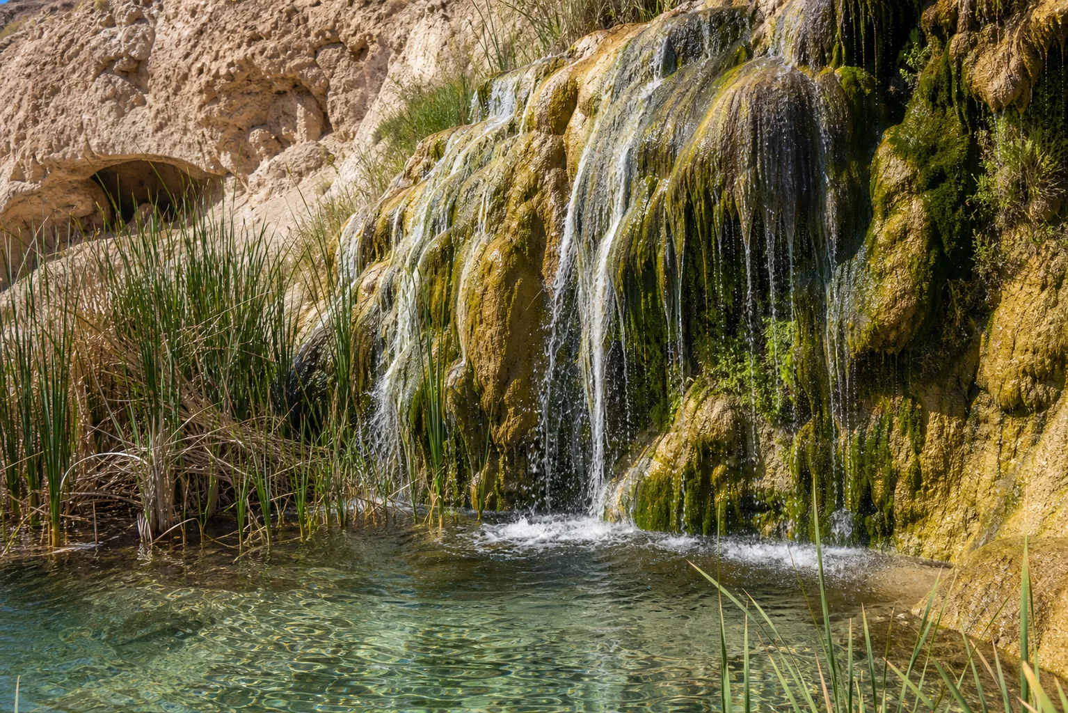
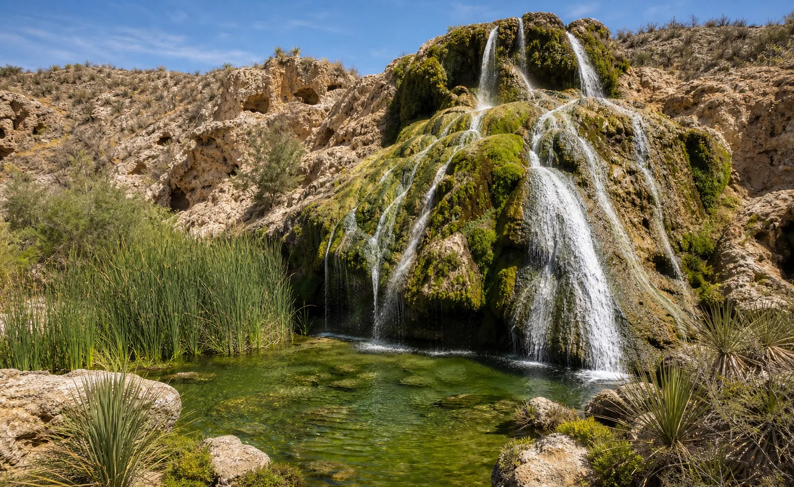
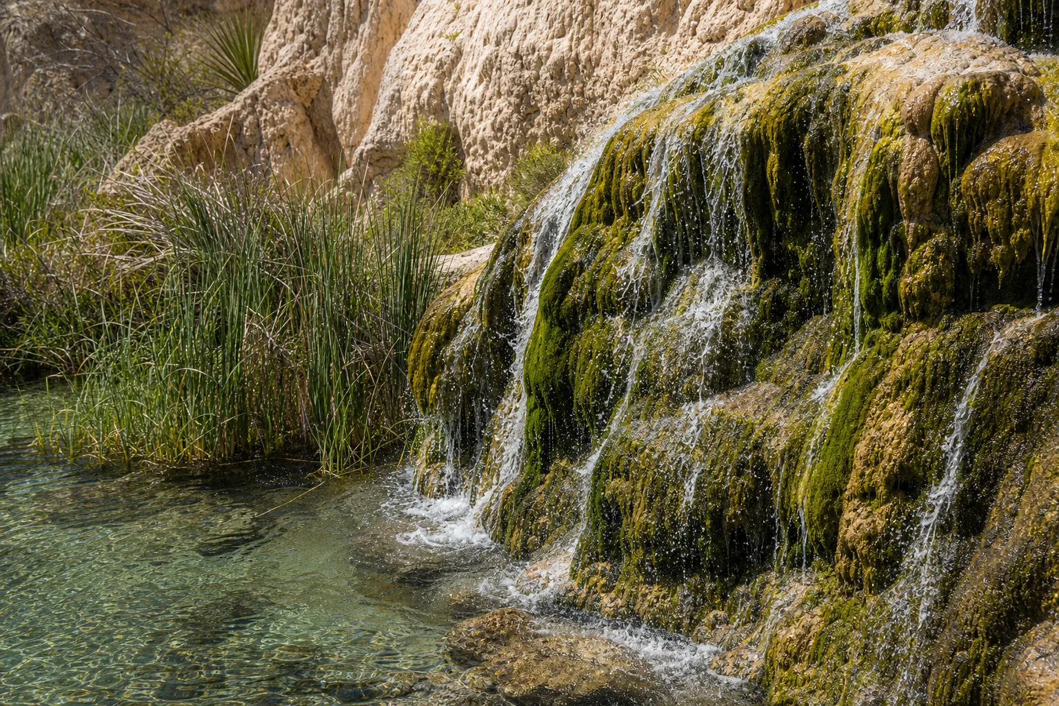
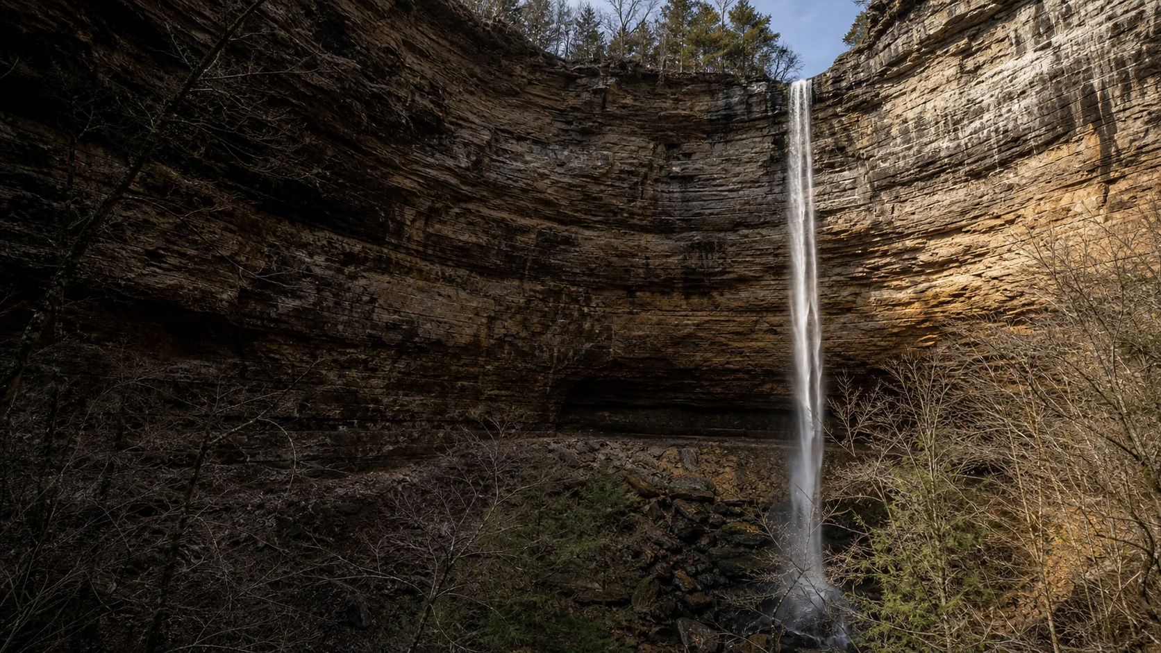
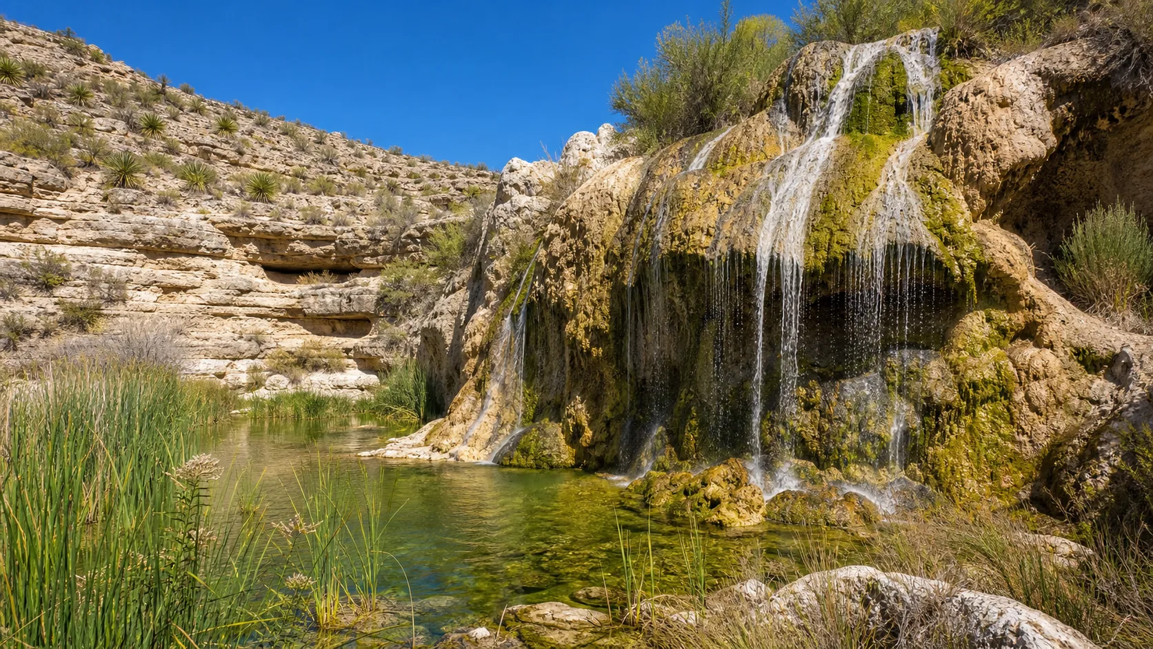
Yes, and the year-round spring flow is what makes it unusual: this is one of the few reliable waterfalls in the Chihuahuan Desert, and it runs even in dry months. Spring (March to May) and fall (October to November) are the easiest visits because daytime temperatures are comfortable; in summer, arrive at the 9 a.m. gate opening to beat the heat. The Forest Service runs the site as a day-use area only: gates open 9 a.m. to 4 p.m., last entry 3:30 p.m., $5 per vehicle.

  • 150 ft travertine-tiered falls
  • 42 mi southwest of Carlsbad
  • $5 per vehicle USFS fee
  • Open 9am to 4pm daily
  • Last entry 3:30pm
  • Year-round spring flow
  • Swimming allowed in pool
  • ADA-accessible viewing path
Last verified May 12, 2026 Visited Desk-verified May 2026 8 sources checked
Distance 0.2 mi 3.8 mi extended
Round trip 15-120 min ADA-accessible viewing path; longer desert trails optional
Difficulty Easy ADA-accessible viewing path; longer desert trails optional
Location Carlsbad, NM Sitting Bull Falls Recreation Area
Parking $5 per vehicle USFS day-use fee; interagency passes accepted USFS
Transit No fixed-route transit Drive via NM-137 / Forest Road 276 · 0 ft
Drive 42 mi 60 min from downtown
Best season Mar-May, Oct-Nov After spring rain
Sitting Bull Falls spring-fed pool at the base of the falls
Photo guide

Three working angles on a 150-foot travertine cascade.

The viewing platform, the pool edge, and the Overlook Trail #215 rim. Use the captions to pick angles before you commit to the heat of a longer trail.

Sitting Bull Falls waterfall and surrounding setting
Sitting Bull Falls, hero composition
Sitting Bull Falls wide view of the multi-tier travertine cascade in its Chihuahuan Desert canyon
Wide canyon view of the 150-foot travertine cascade
Sitting Bull Falls spring-fed pool at the base of the multi-tier travertine cascade
Spring-fed pool at the base of the falls
Sitting Bull Falls travertine rimstone dam and cascade water detail
Travertine rimstone dam and cascade detail
01Is Sitting Bull Falls flowing right now?

No paired real-time USGS discharge gauge exists for Sitting Bull Spring or the falls. The spring system runs year-round; recent weather and management closures still control whether the gate is open.

Flow is spring-fed and steady year-round. After heavy regional thunderstorms in the summer monsoon, the canyon below the recreation area can run with flash-flood debris flow; the Forest Service closes the gate during active flood and fire restrictions.

02How long is the walk?

The viewing platform is a short paved walk from the parking area; round trip is roughly a quarter mile. Overlook Trail #215 is 1.9 miles to the rim view; Sitting Bull Falls Trail #68 (the spring trail above the falls) adds a longer desert option.

03How do you get there?

From Carlsbad, the standard route is north on US-285 for about 12 miles, west on NM-137 for about 25 miles into the Guadalupe foothills, then a left onto Forest Road 276 for the final 8 miles into the recreation area. The road is paved the entire way but it is remote, narrow in spots, and has no services after you leave Carlsbad; plan a full tank of gas and download offline maps before leaving town.

04Is there free parking?

Parking is inside the gated recreation area. The $5 per vehicle USFS day-use fee covers the lot.

05Does it cost money?

$5 per vehicle per day, paid at the entrance gate. Interagency passes (America the Beautiful, Senior, Access) are accepted in lieu of the day-use fee. No reservations required.

06Trail variants

Viewing path short paved path, 10-20 min, ADA-accessible route from the parking area.
Falls pool stop 0.2 mi round trip, 30-60 min, picnic, photos, and pool time when conditions allow.
Sitting Bull Falls Trail #68 desert trail option, 1-2 hr, check heat and water before committing.
Overlook Trail #215 1.9 mi, 1-2 hr, dead-ends at an overlook of the falls area.

Detailed maps and recent reviews: Falls route on AllTrails · Creek route on AllTrails

07Can you swim?

Yes, swimming is allowed in the main pool when the site is open, and the cold spring water is the reason most summer visitors come. There is no lifeguard, the pool is rocky and uneven underfoot, and the Forest Service closes the site during posted flood or water-quality events.

08Are dogs allowed?

Dogs are allowed on leash in the picnic area and on the trails. Keep them out of the swimming pool, off the travertine terraces (the calcium-carbonate surface is fragile), and pack out waste.

09Is it accessible?

Yes for the main view. The Forest Service describes an ADA-accessible paved path from the parking area to the falls viewing platform; the longer desert trails are not accessible.

Field notes

Sitting Bull Falls at a glance.

150-foot multi-tier travertine cascade over Capitan Reef limestone, spring-fed flow year-round, Lincoln National Forest, Guadalupe Ranger District, $5 per vehicle USFS day-use fee, gates 9 a.m. to 4 p.m. with last entry 3:30 p.m. Sourced from the U.S. Forest Service Sitting Bull Falls Recreation Area page.

Height 150 ft USGS 3DEP
Type Spring-fed travertine cascade USGS
County Eddy Carlsbad, NM
Managed by U.S. Forest Service USFS
Water source Spring-fed canyon flow USGS
Elevation 5000 ft USGS NED
Park area 1,100,000 acres USFS
Hours 9am to 4pm daily; last entry 3:30pm USFS
When to visit

Year-round flow, comfortable shoulder seasons.

Spring (March through May) and fall (October through November) are the easiest because daytime temperatures are pleasant in the canyon. Summer (June through August) is hot but cools at the pool; arrive at the 9 a.m. gate opening. Winter is uncrowded; freezes are rare but possible, and the gate hours hold.

MONSOON

Peak flowAfter spring rain
Ice / low flowRare
Most crowdedWeekends and midday
Best photosSunrise or weekdays

Live water context

Discharge data -- No paired real-time USGS discharge gauge exists for Sitting Bull Spring or the falls. The spring system runs year-round; recent weather and management closures still control whether the gate is open.

Why is it called Sitting Bull Falls?

The name is attached to a folkloric story tying the canyon to the Hunkpapa Lakota leader Sitting Bull (Tȟatȟáŋka Íyotake, 1831 to 1890), with versions claiming his band hid stolen horses here, watered them at the spring, or simply passed through on a southern raid. No documented historical record supports any of those connections; Sitting Bull's known range was the Northern Plains, not the southern Guadalupe Mountains.

The waterfall has carried the name on Forest Service maps since the early twentieth century, and it is the most likely source of the broader recreation-area, canyon, and Sitting Bull Falls Trail #68 names. It is distinct from Sitting Bull Falls or Sitting Bull namesake features elsewhere in the West, including the Black Hills geology associated with the leader's documented territory.

What else to do at Sitting Bull Falls Recreation Area

Sitting Bull Falls Recreation Area sits inside the Guadalupe Ranger District of Lincoln National Forest, the southern unit of the forest closest to Texas and to Carlsbad Caverns National Park. The day-use site has shaded picnic shelters, tables, grills, restrooms, potable water, and a short paved route from the parking area to the falls viewing platform; there is no overnight camping inside the recreation area. The Forest Service operates a controlled entrance gate, and the broader region anchors a small national-park triangle with Guadalupe Mountains National Park about 90 minutes south and Carlsbad Caverns 75 minutes east.

  • Travertine cascade and viewing platform. The 150-foot multi-tier drop spills down rimstone dams of pale limestone into the main pool; the paved viewing platform sits a few minutes from the parking area.
  • Spring-fed pool. The main pool below the cascade is cold, clear, and stays full through the dry months because the springs run year-round. Swimming is allowed when the site is open.
  • Picnic area with shelters. Built-in shelters with tables, grills, restrooms, potable water, and trash service make this an unusually developed day-use stop for a Forest Service site.
  • Sitting Bull Falls Trail #68 and Overlook Trail #215. Two desert hikes leave from the recreation area, both for cooler days; Overlook Trail #215 climbs 1.9 miles to a rim view of the falls.

Why it looks this way

The falls drops over the eroded edge of the Capitan Reef, a Permian-age fossil reef limestone that forms the spine of the Guadalupe Mountains and the same rock that hosts the chambers of Carlsbad Caverns National Park about 50 miles east. Calcium-rich spring water emerges into the canyon and rapidly precipitates travertine (calcium carbonate) as carbon dioxide degasses, building the tiered rimstone dams and the pale terraces visible across the cascade face. The springs themselves are fed by deep groundwater circulating through the reef and surrounding Guadalupe section, which is why the discharge holds steady through the dry months when surface runoff in the Chihuahuan Desert is essentially nonexistent.
Field guide deep dive

What you cannot tell from the Forest Service listing.

How the Capitan Reef built a desert waterfall, what the 9-to-4 gate actually means in practice, the swimming reality, the Sitting Bull naming question. Skim the headers, read what you need.

How Sitting Bull Falls formed: Capitan Reef, springs, and travertine

The bedrock under Sitting Bull Falls is the Capitan Reef, a Permian-age fossil reef that grew along the edge of a tropical inland sea roughly 260 million years ago. The same formation builds the cliffs of Guadalupe Mountains National Park and hosts the dissolution chambers of Carlsbad Caverns about 50 miles east. At Sitting Bull, the reef limestone has been uplifted and dissected by drainages flowing off the southern Guadalupes, and the falls sits where the canyon walls of one of those drainages cuts through the reef edge.

The waterfall itself is not just a limestone cliff with water on it. Calcium-rich groundwater emerges from Sitting Bull Spring a short distance above the falls; as the water hits open air and degasses carbon dioxide, it loses its capacity to hold dissolved calcium carbonate and starts to precipitate travertine on every surface it touches. Over time, those precipitates build the tiered rimstone dams that give the cascade its multi-stepped, terraced appearance, with mosses and algae growing on the pale carbonate. The system is genetically related to other travertine sites in the southwestern US and is an active depositional landform, not a fossil one. The face of the falls is, slowly, still growing.

The Chihuahuan Desert paradox: year-round water in a 15-inch-rain region

The Carlsbad and Guadalupe region averages about 15 inches of precipitation per year, most of it concentrated in the summer monsoon and in occasional winter storms. Surface streams in the Chihuahuan Desert at this elevation are almost entirely ephemeral; the arroyos around Sitting Bull Falls run only after thunderstorms. The reason there is a waterfall here at all is that the discharge is not surface-driven but spring-fed, sourced from groundwater stored in and circulating through the surrounding Capitan Reef and Guadalupe section.

That groundwater system has long residence times and a large storage volume, which is why the springs and the falls run through the dry months when nothing else does. The flow is not constant in the strict sense (long-term droughts and groundwater pumping in the region can affect it), but on any given visit, in any given season, water is falling. That is rare in this landscape. The Forest Service describes the site as a desert oasis for that reason, and the description is not marketing copy; it is geomorphology.

Operational reality: 9 to 4, last entry 3:30, no overnight camping

Sitting Bull Falls is a day-use only recreation area run by the Forest Service. The entrance gate opens at 9 a.m. and closes at 4 p.m.; the staff stops admitting vehicles at 3:30 p.m. so the lot can clear by closing. There is no overnight camping inside the gated area, no fires outside the provided grills, and no entry after hours. The fee is $5 per vehicle, paid at the entrance station; interagency passes (America the Beautiful, Senior, Access) are accepted in lieu of the daily fee.

The access drive matters. From Carlsbad, the route is north on US-285 to NM-137, then west into the Guadalupe foothills on NM-137 for roughly 25 miles, then a left turn onto Forest Road 276 for the final 8 paved miles into the canyon. The road is paved the whole way but it is remote, with no fuel, no cell service in long stretches, and almost no facilities once you leave Carlsbad. Plan a full tank of gas, water in the car, and downloaded offline maps. Dispersed camping is available on adjacent Forest Service land outside the recreation area itself but requires its own preparation.

Swimming in the travertine pools: allowed, cold, popular in summer

Swimming is allowed at Sitting Bull Falls when the recreation area is open, and the cold spring-fed pool below the cascade is the reason a large share of summer visitors come. The water is genuinely cold year-round because the springs emerge at relatively constant groundwater temperatures; on a 100-degree June afternoon the contrast is the entire point of the trip. There is no lifeguard, the bottom is uneven travertine and limestone with submerged rocks, and currents at the base of the cascade can be stronger than they look.

A few practical notes. Bring water shoes; the rimstone surfaces are sharp underfoot. Do not climb on the travertine terraces above the main pool; the carbonate crust is fragile and biologically active. Sunscreen and personal-care products break down the algal mats on the rimstone, so rinse off before getting in if you have just applied them. The pool can be closed during posted water-quality events, flash-flood warnings in the canyon, or fire restrictions; the Forest Service updates the recreation-area page when closures are in effect.

The Carlsbad waterfall day: caverns, falls, and a desert garden

Sitting Bull Falls pairs naturally with the two other anchor attractions in the Carlsbad region. Carlsbad Caverns National Park sits about 75 minutes east of the falls and holds the show cave that made the area famous; it is built on the same Capitan Reef limestone the falls cuts through, which is why both sites share a geologic story even though they look completely different on the surface. The Living Desert Zoo & Gardens State Park inside Carlsbad is the third leg, a small zoo and botanic garden organized around Chihuahuan Desert species that gives context to the landscape you are driving through.

A standard two-day loop is caverns on day one (arrive early, the cave tour and natural entrance walk take half a day) and Sitting Bull Falls plus Living Desert on day two, ordered by gate times: falls first because the entrance closes at 3:30 p.m., Living Desert in the late afternoon. Guadalupe Mountains National Park about 90 minutes south of the falls is a separate, longer trip if you want a real backcountry day.

Etymology: a folkloric tie to Sitting Bull with no documented history

The waterfall is named for Sitting Bull (Tȟatȟáŋka Íyotake, c. 1831 to 1890), the Hunkpapa Lakota leader best known for the resistance to US military expansion on the Northern Plains and for the 1876 Battle of the Little Bighorn. Local stories tie his band to this canyon in versions that involve hidden horses, watering stock at the spring, or a southern raid through the Guadalupes. None of those stories appear in any documented historical record; Sitting Bull's known territory was the Dakotas and Montana, and there is no biographical evidence placing him in the Trans-Pecos.

The name has nonetheless been attached to the falls since at least the early twentieth century, when the Forest Service began mapping the site, and it carries through to the recreation area, the canyon, the spring, and Sitting Bull Falls Trail #68. The naming is most accurately treated as folklore: a regional story attached to a national figure, not a documented connection. It is also distinct from other Sitting Bull namesake features in the West, including the Black Hills sites and waterways in the actual Lakota homeland that have their own naming history. For the Lakota perspective on Sitting Bull himself, the Standing Rock Sioux Tribe and the Sitting Bull family descendants are the authoritative references.

Map and route

About 60 minutes from Carlsbad, last 8 miles on Forest Road 276.

From Carlsbad, the standard route is north on US-285 for about 12 miles, west on NM-137 for about 25 miles into the Guadalupe foothills, then a left onto Forest Road 276 for the final 8 miles into the recreation area. The road is paved the entire way but it is remote, narrow in spots, and has no services after you leave Carlsbad; plan a full tank of gas and download offline maps before leaving town.

Wildlife

Chihuahuan Desert birds at a real water source.

A perennial pool in a 15-inch-rain desert is a magnet for wildlife. Canyon wrens nest in the limestone cliffs and their cascading song carries above the falls; greater roadrunners cross the picnic area on hot afternoons; desert cottontails and southwestern fence lizards are common at trail edges.

Canyon Wren
Canyon Wren
Catherpes mexicanus
Year-round resident in the limestone cliffs around the falls; the cascading descending song carries over the water and is the signature soundtrack of the canyon.
Greater Roadrunner
Greater Roadrunner
Geococcyx californianus
Crosses the picnic area and the parking lot edges on hot afternoons; the bird hunts lizards in the brush around the Forest Road 276 approach.
Desert Cottontail
Desert Cottontail
Sylvilagus audubonii
Common at first light and late afternoon along the desert trails outside the recreation area; tends to hold motionless in low brush rather than flush.
Southwestern Fence Lizard
Sceloporus cowlesi
Basks on the sun-warmed limestone above the falls and on the rocks around the picnic shelters; most active in the warm half of the day.
Photography and weddings

Shaded canyon, paved platform, no drones without USFS clearance.

The viewing platform and the pool edge give the two working frames: the platform for the full multi-tier travertine face, the pool edge for the lower cascade and the green water against the pale rimstone. The Overlook Trail #215 turnaround gives the rim-view wide shot, but the heat and time commitment make that an early-morning option only.

The canyon walls keep the falls in shade well into mid-morning, which is the easiest light because pale travertine blows out fast under direct desert sun. Thin cloud or an overcast day flattens highlights and brings up the emerald color in the pool. Plan around the 9 a.m. opening if you want soft light.

Personal photography is fine. Drones are restricted on most Lincoln National Forest land; commercial shoots, weddings, or large staged sessions need to clear with the Guadalupe Ranger District before the visit.

Permits

Weddings and engagements

The day-use window (9 a.m. to 4 p.m., last entry 3:30 p.m.) and the per-vehicle fee make formal weddings tough; small elopement ceremonies have been hosted here but require coordination with the Forest Service.

Confirm any ceremony, commercial, or reserved-use requirements with the Guadalupe Ranger District before planning around the site.

Keep groups small, do not block the viewing platform or the paved path, and plan to be out before the gate closes.

Nearby waterfalls

The Carlsbad waterfall day: caverns, falls, desert garden.

Sitting Bull Falls pairs naturally with Carlsbad Caverns National Park (75 minutes east) and the Living Desert Zoo & Gardens State Park inside Carlsbad. A standard two-day loop is caverns on one day, falls plus Living Desert on the other, with Guadalupe Mountains National Park reserved for a longer trip.

Related questions

More questions visitors ask before driving to Sitting Bull Falls.

Height, hours, swimming, dogs, fee, the access road, and the worth-visiting answer. The full set is also indexed in the FAQ schema for AI answer engines.

01How tall is Sitting Bull Falls?

About 150 feet (45.7 meters), measured as a multi-tier travertine cascade rather than a single straight drop. The water spills down a sequence of rimstone dams of pale limestone built up over time by calcium-carbonate precipitation from the spring-fed flow.

02What time does Sitting Bull Falls open?

The Forest Service gate opens at 9 a.m. and closes at 4 p.m. daily; the last entry is 3:30 p.m. so the parking lot can clear by closing. The site is day-use only with no overnight camping inside the recreation area.

03Is Sitting Bull Falls free?

No. The U.S. Forest Service charges a $5 per vehicle day-use fee at the entrance gate. Interagency passes including America the Beautiful, Senior, and Access passes are accepted in lieu of the daily fee. No reservation is required.

04How do you get to Sitting Bull Falls?

From Carlsbad, drive north on US-285 for about 12 miles, then west on NM-137 for about 25 miles into the southern Guadalupe Mountains, then a left turn onto Forest Road 276 for the final 8 paved miles into the recreation area. The drive is roughly 60 minutes and the road is paved the whole way, but it is remote with no fuel or services after Carlsbad.

05Is Sitting Bull Falls worth visiting?

Yes if you are anywhere near Carlsbad. A 150-foot multi-tier travertine cascade with a year-round swimming pool in the middle of the Chihuahuan Desert is rare on its own, and the developed picnic area makes it an easy half-day stop. The drive is the only commitment; once inside the gate, the main viewing platform is a short paved walk.

06Why is it called Sitting Bull Falls?

The falls is named for the Hunkpapa Lakota leader Sitting Bull (Tȟatȟáŋka Íyotake, c. 1831 to 1890), but the naming comes from a local folkloric story rather than a documented historical connection. Sitting Bull's known range was the Northern Plains, and there is no biographical record placing him in the Guadalupe Mountains of southern New Mexico.

Sources and data

Where the Sitting Bull Falls guide gets its facts.

Hours, fee, ADA path, and recreation-area description from the U.S. Forest Service Lincoln National Forest. Geology from regional Capitan Reef and Permian Guadalupe Mountains references. Climate from the NOAA/NWS Midland forecast grid. Naming and disambiguation cross-checked against Wikipedia and Wikidata.

USFS: Sitting Bull Falls Recreation Area fs.usda.gov
Access, parking, and permit rules: fs.usda.gov
New Mexico Bureau of Geology & Mineral Resources: Capitan Reef and Permian Guadalupe Mountains: Carlsbad bedrock geoinfo.nmt.edu
NOAA / NWS Midland forecast grid MAF 26,150 noaa.gov
USGS National Elevation Dataset 3DEP
Wikidata: Q2041367 (Sitting Bull Falls) wikidata.org
Google Maps: embedded map and directions maps.google.com
Google Places: nearby restaurants and hotels places API
U.S. Forest Service: Sitting Bull Falls Recreation Area (Lincoln National Forest) fs.usda.gov
U.S. Forest Service: Guadalupe Ranger District fs.usda.gov
New Mexico True: Sitting Bull Falls Recreation Area newmexico.org
New Mexico Bureau of Geology & Mineral Resources: Sitting Bull Falls geotour geoinfo.nmt.edu
Wikipedia: Sitting Bull Falls en.wikipedia.org
AllTrails: Sitting Bull Falls Trail alltrails.com
Wikimedia Commons: Sitting Bull Falls image category commons.wikimedia.org
Wikidata: Sitting Bull Falls (Q2041367) wikidata.org
Fact checks
Height audit: the 150-foot figure for the multi-tier travertine cascade is the published U.S. Forest Service value and matches the New Mexico Bureau of Geology geotour and the AllTrails trail description.
Gate-hours audit: 9 a.m. to 4 p.m. daily with last entry 3:30 p.m. comes from the current Lincoln National Forest Sitting Bull Falls Recreation Area page; the gate operates as a controlled entrance station and clears the lot by closing.
Fee audit: the $5 per vehicle USFS day-use fee is the current posted rate, and interagency passes (America the Beautiful, Senior, Access) are accepted.
Swimming-policy audit: the Forest Service permits swimming in the main pool when the site is open; there is no lifeguard, the bottom is uneven travertine, and the pool can be closed during posted flash-flood, fire, or water-quality events.
Corrections: [email protected]