Nugget Falls plunging 377 feet down dark Coast Mountains bedrock into Mendenhall Lake with the glacier valley behind
Juneau, AK

Nugget Falls

Nugget Falls is a 377-foot two-tier plunge on Nugget Creek that drops directly into Mendenhall Lake inside the Mendenhall Glacier Recreation Area, a quiet 1.0-mile flat walk from the Visitor Center along the lake. It is the photograph most cruise visitors actually take home, because the Mendenhall Glacier face has retreated far enough that the falls is now the closer, louder, and more reliably full-frame subject.

Last verified May 12, 2026 Visited Desk-verified May 2026 7 sources checked
Trail 2.0 mi 3.5 mi extended
Time 30-90 min Easy
Best season Mid-May through late September Late June through early August (glacial melt)
Parking $5 day-use fee at the Visitor Center lot in summer; federal passes accepted; lot fills before 10 a.m. on cruise ship days Mendenhall Glacier Recreation Area, Tongass National Forest
Quick answer

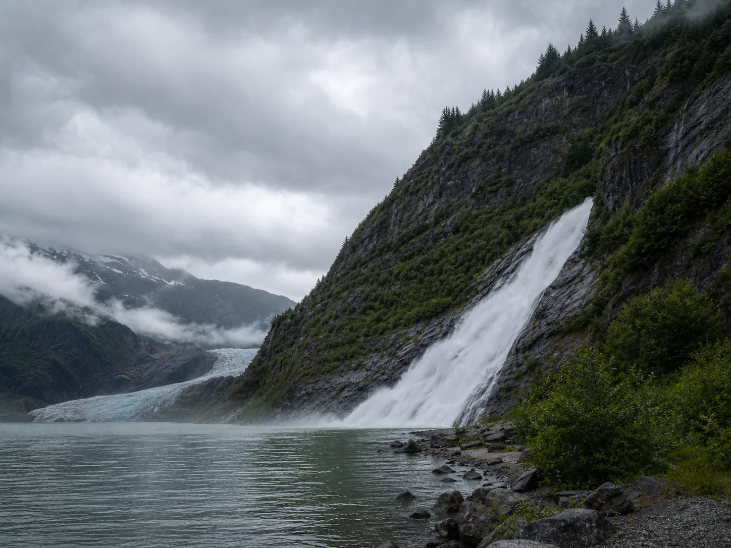
Is Nugget Falls worth visiting today?

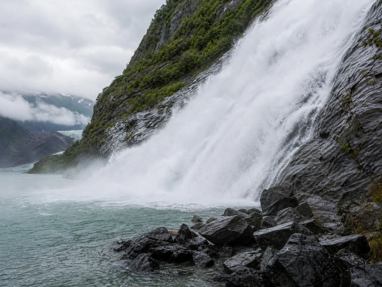
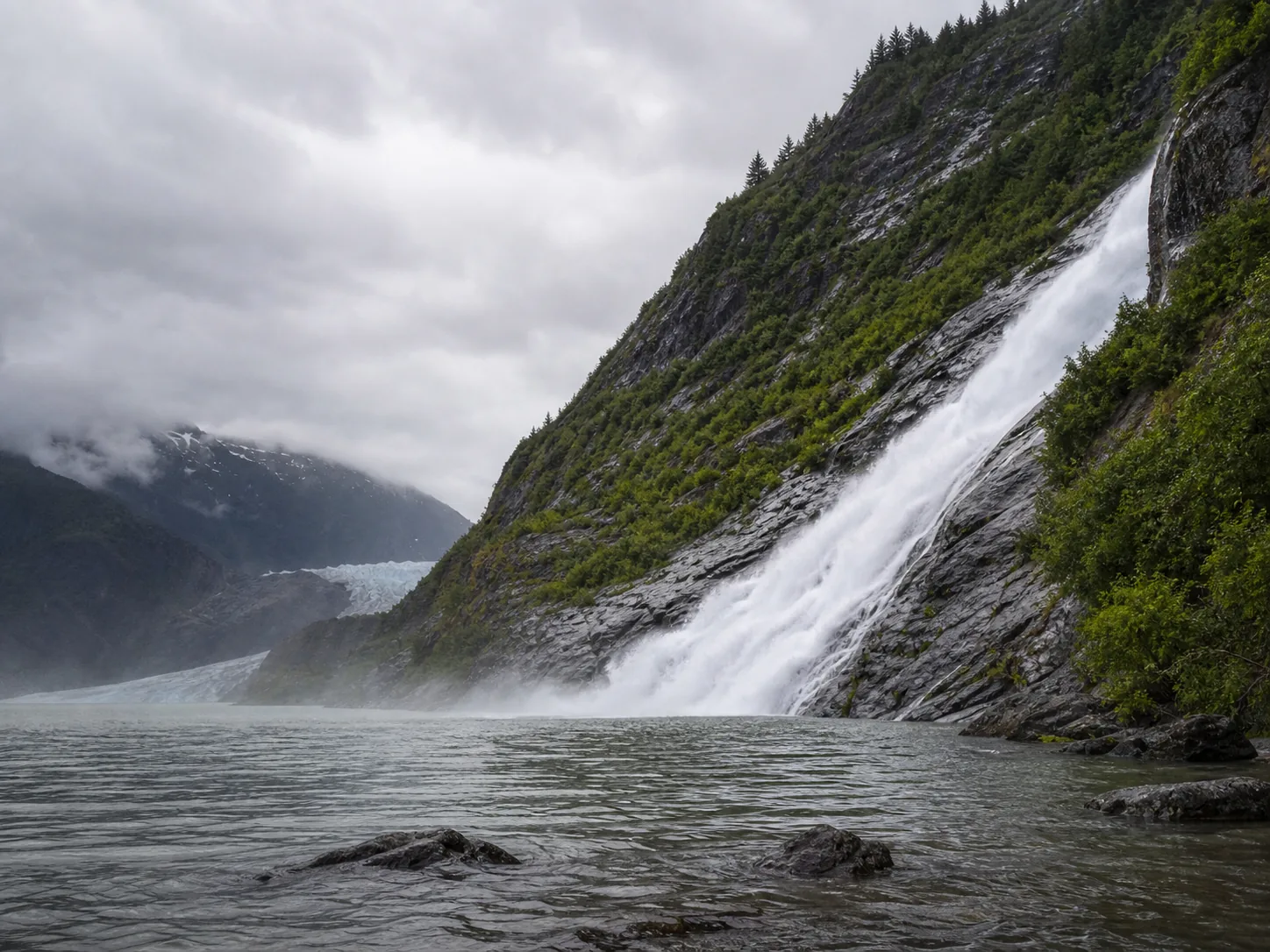
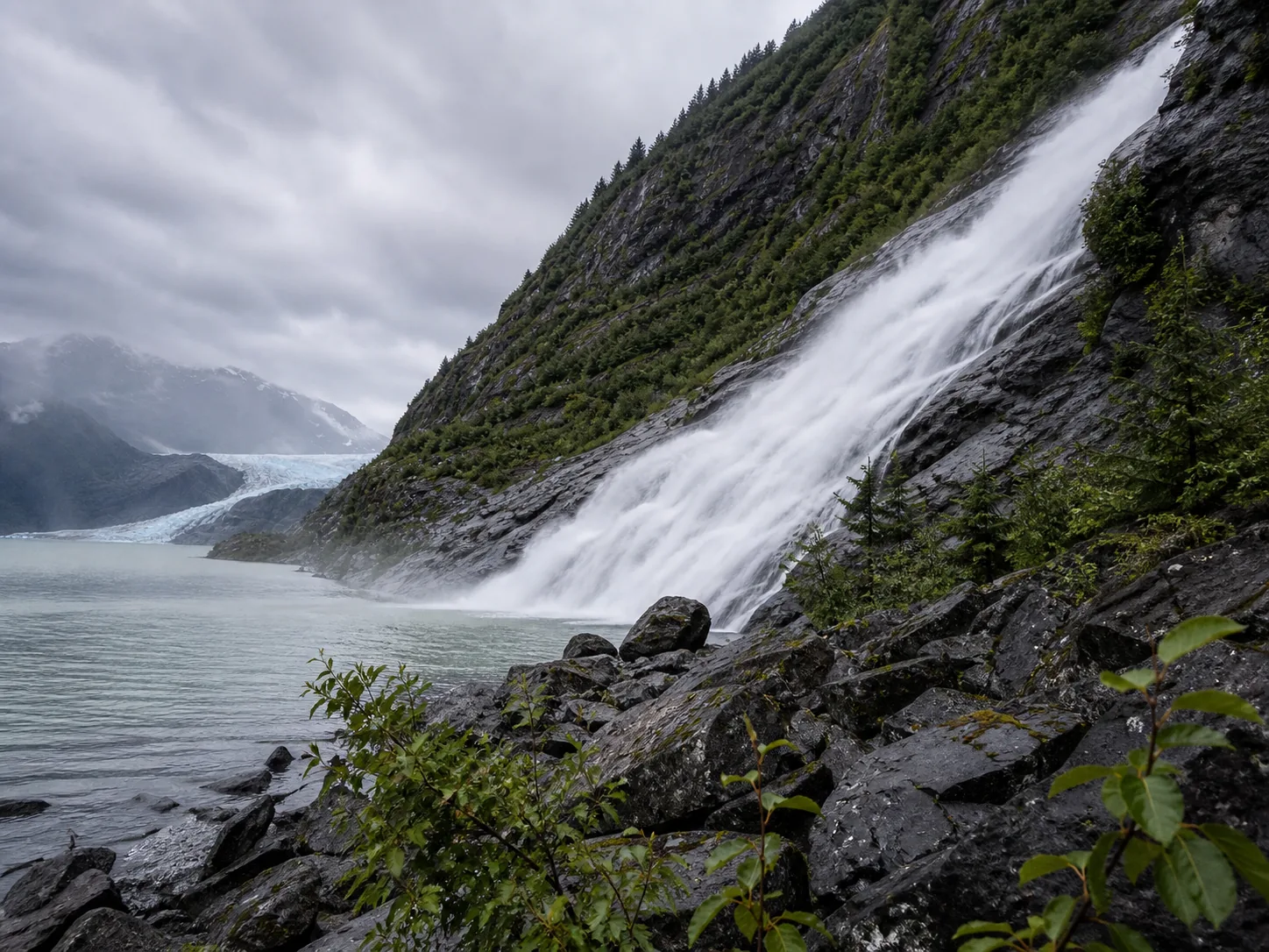
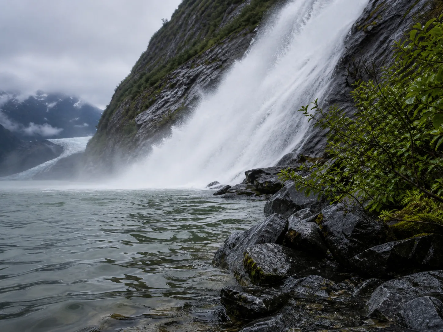
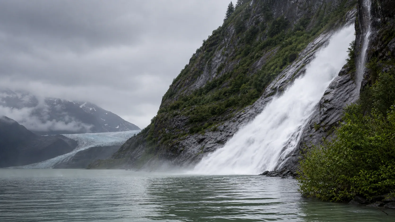
Yes. The trail is a flat 1.0-mile gravel and pavement walk along Mendenhall Lake from the Visitor Center to the base of a 377-foot waterfall that drops into a glacial lake with the Mendenhall Glacier visible across the water. Late June through early August is the loudest window because the falls is fed by snow and glacial melt, and the Mendenhall River gauge often runs above 2,000 cfs. May, September, and early October still work for photos with thinner crowds; in shoulder season the falls reads more delicate but the trail is far quieter.

  • 377-foot two-tier plunge
  • Flat 1.0-mile lake-edge trail
  • Tongass National Forest, Juneau
  • Peak flow: late June to early August
  • $5 day-use fee in summer
  • Mendenhall Glacier visible across the lake
Last verified May 12, 2026 Visited Desk-verified May 2026 7 sources checked
Distance 2.0 mi 3.5 mi extended
Round trip 30-90 min Mostly flat, hard-packed gravel and pavement along Mendenhall Lake; stroller-friendly to the base viewpoint
Difficulty Easy Mostly flat, hard-packed gravel and pavement along Mendenhall Lake; stroller-friendly to the base viewpoint
Location Juneau, AK Mendenhall Glacier Recreation Area, Tongass National Forest
Parking $5 day-use fee at the Visitor Center lot in summer; federal passes accepted; lot fills before 10 a.m. on cruise ship days USFS Tongass
Transit Capital Transit Route 3 (Mendenhall Valley) plus the Glacier Express shuttle DeHart's / Mendenhall Loop Road; shuttle continues to the Visitor Center · 200 ft
Drive 13 mi 25 min from downtown
Best season Mid-May through late September Late June through early August (glacial melt)
Nugget Falls mid-summer glacial-melt force at the base of the falls
Photo guide

Three working positions for a 377-foot Alaskan plunge.

The Photo Point loop for the long composite shot with the glacier across the water, the lake-edge midpoint for an iceberg-foreground frame, and the gravel beach at the base for the dramatic upward look. Use the captions to pick angles before you walk the mile.

Nugget Falls plunging 377 feet down dark Coast Mountains bedrock into Mendenhall Lake with the glacier valley behind
Nugget Falls, hero composition
Wide lakeshore view of Nugget Falls dropping 377 feet into Mendenhall Lake near Juneau
The full 377-foot two-tier drop into Mendenhall Lake, with the glacier valley across the water
Spray and white water at the base of Nugget Falls during peak glacial melt season
Mid-summer glacial-melt force at the base of the falls
Side angle of Nugget Falls from the Mendenhall Lake gravel shoreline
Shoreline side angle from the gravel beach approach
Wet rock and glacial water detail along the shoreline below Nugget Falls
Wet shoreline rock and glacial silt detail
Nugget Falls framed by Mendenhall Lake, dark Coast Mountains cliffs, and low marine clouds
Falls, lake, and Mendenhall Glacier valley in one frame
01Is Nugget Falls flowing right now?

Live data: USGS gauge 15052500 (Mendenhall River near Auke Bay) ↑, period of record 1996 to present, drainage roughly 87 square miles including the Mendenhall Glacier and Nugget Creek watersheds. The 30-year daily-discharge median is 424 cfs; the 75th percentile is 2,270 cfs; the 90th percentile is 3,540 cfs; the historical maximum is 21,900 cfs during a 2024 glacial outburst flood. The Mendenhall River is the drainage outlet for the entire watershed including Nugget Creek, so the gauge is a reliable proxy for falls volume.

02How long is the walk?

About 1.0 mile each way (2.0 miles round trip) from the Visitor Center to the base of the falls, with effectively no elevation gain. The connector from the Photo Point loop is signed, and the trail surface is hard-packed gravel and short paved sections. Most visitors take 45 to 75 minutes round trip including time at the base.

03How do you get there?

From downtown Juneau, take Egan Drive west, then Mendenhall Loop Road, then Glacier Spur Road to the Visitor Center (about 25 minutes, 13 miles). From Juneau International Airport, it is 12 minutes north via Mendenhall Loop Road. Capital Transit Route 3 plus the Glacier Express shuttle reach the Visitor Center area; from a cruise ship pier, blue line buses and operator shuttles run on a fixed schedule.

04Is there free parking?

The Visitor Center lot at the end of Glacier Spur Road is the main parking area. A $5 day-use fee applies per adult between May 1 and September 30; federal Interagency, America the Beautiful, and senior or access passes cover the fee. The lot fills before 10 a.m. on cruise ship days. Limited free roadside pull-offs exist near Skater's Cabin Road outside the day-use boundary.

05Does it cost money?

A $5 day-use fee per adult is collected at the Visitor Center between May 1 and September 30; outside those dates entry is free. Children under 16 are free, and federal Interagency, America the Beautiful, Senior, and Access passes cover the fee. Drone permits and wedding or commercial permits are separate and start around $100 from the Juneau Ranger District.

06Trail variants

Nugget Falls Trail (out-and-back to falls base) 2.0 mi round trip, 45 to 75 min, from the Visitor Center via the Photo Point connector; about 1.0 mile each way along Mendenhall Lake.
Photo Point Trail (glacier overlook only) 0.6 mi round trip, 20 min, paved, accessible loop with the classic Mendenhall Glacier and Nugget Falls long view.
Trail of Time loop 1.0 mi loop, 40 min, interpretive loop near the Visitor Center; pair with Nugget Falls for a 3 to 3.5 mile half-day.
East Glacier Loop (longer add-on) 3.5 mi loop, 2.5 hr, climbs about 500 ft for an elevated view down onto the falls and lake; not flat.

Detailed maps and recent reviews: Falls route on AllTrails · Creek route on AllTrails

07Can you swim?

No. Mendenhall Lake is glacial meltwater with surface temperatures around 35 to 40 degrees Fahrenheit even at the height of summer, and floating icebergs that calve from the glacier face drift through the swim line without warning. Treat the lake and the plunge pool as cold-shock dangerous regardless of how calm the surface looks.

08Are dogs allowed?

Dogs are allowed on a leash on the Nugget Falls Trail, the Photo Point loop, and most Mendenhall Recreation Area trails. The Visitor Center building itself is service-animal only. Keep dogs leashed because of regular bear activity and because dogs can spook calving icebergs into sudden movement.

09Is it accessible?

The Photo Point loop is paved and accessible to the long-distance Nugget Falls view. The Nugget Falls Trail itself is hard-packed gravel, mostly flat, and passable for many manual and motorized wheelchairs in dry conditions; the last few hundred feet to the falls base cross loose gravel and rounded shoreline rocks that are not chair-friendly.

Field notes

Nugget Falls at a glance.

377-foot two-tier plunge on Nugget Creek, Coast Mountains intrusive bedrock, drainage about 87 sq mi at the Mendenhall River gauge, managed by the US Forest Service inside Tongass National Forest, $5 summer day-use fee, trail surface mostly flat hard-packed gravel. Sourced from the Tongass National Forest page and USGS NWIS.

Height 377 ft USGS 3DEP
Type Two-tier plunge USGS
Rock Coast Mountains intrusive bedrock (granodiorite and diorite) US Geological Survey: Coast Mountains intrusive complex bedrock map for Southeast Alaska
County Juneau Juneau, AK
Managed by US Forest Service, Tongass National Forest USFS Tongass
Water source Nugget Creek (downstream of Nugget Glacier) USGS
Elevation 49 ft USGS NED
Park area 5,815 acres USFS Tongass
Hours Trail open year-round; Visitor Center seasonal (May to September, roughly 8am to 7pm in peak summer) USFS Tongass
When to visit

The Alaskan glacier-melt window, and the quieter shoulders.

Late June through early August is the loudest because Mendenhall River discharge regularly clears 2,000 cfs on glacial-melt afternoons. May and September trade volume for fewer cruise visitors. The seasonal read and the live USGS gauge on the right tell you which one you are walking into today.

PEAK FLOW

Peak flowLate June through early August (glacial melt)
Ice / low flowDecember through March (partial freeze, trail rarely maintained)
Most crowdedWeekends and midday
Best photosSunrise or weekdays

Live water context

Discharge data -- Live reading from Mendenhall River near Auke Bay, AK (USGS 15052500) refreshes on the next build. Open the gauge link below for the current cubic-feet-per-second reading.

USGS 15052500 · Mendenhall River near Auke Bay, AK

Why is it called Nugget Falls?

The waterfall takes its name from Nugget Creek, which was named during the gold-prospecting era around Juneau in the late nineteenth century. Joe Juneau and Richard Harris struck gold in the Juneau area in 1880, and within a few years prospectors had named most of the creeks draining the surrounding mountains for the obvious reason: they were panning for gold-bearing gravels in the streams. Nugget Creek was one of them. The waterfall, the small glacier above it, and the trail all inherited the same name.

The Tlingit people, who have lived in this area for thousands of years, have their own placenames for the glacier and the surrounding land. The Mendenhall Glacier itself is Sit'aa'k'w in Tlingit, sometimes rendered as Aak'wtaaksit'i, meaning roughly the glacier behind the small lake. The English name Mendenhall comes from Thomas Corwin Mendenhall, superintendent of the US Coast and Geodetic Survey in 1891. If you want the Tlingit perspective on this landscape, the Sealaska Heritage Institute in downtown Juneau is the canonical reference.

What else to do at Mendenhall Glacier Recreation Area, Tongass National Forest

Nugget Falls sits inside the Mendenhall Glacier Recreation Area, a 5,815-acre unit of Tongass National Forest managed by the US Forest Service. The Mendenhall Glacier Visitor Center is the hub: it opened in 1962 as the first Forest Service visitor center in the country, holds interpretive exhibits about the Juneau Icefield, has restrooms and a small theater, and is the only place to confirm same-day trail conditions, bear activity reports, and short-notice closures. The Nugget Falls Trail begins as a connector off the Photo Point loop a short walk from the Visitor Center and runs about 1.0 mile along the south shore of Mendenhall Lake to the base of the falls.

  • Mendenhall Glacier Visitor Center (1962). The first National Forest Service visitor center in the country, with interpretive exhibits on the Juneau Icefield, restrooms, a theater, and the only place to confirm current trail conditions and bear activity.
  • Photo Point Trail. The paved 0.6-mile accessible loop that delivers the classic Mendenhall Glacier and Nugget Falls long view; the Nugget Falls Trail connector starts about halfway around.
  • Nugget Falls Trail. A flat 1.0-mile hard-packed gravel and pavement trail along the south shore of Mendenhall Lake that ends at a shoreline viewpoint a few hundred feet from the base of the 377-foot falls.
  • Trail of Time. An interpretive 1.0-mile loop near the Visitor Center that walks visitors through several decades of glacier retreat, with markers showing where the ice stood at various dates.
  • Mendenhall Lake icebergs. Floating bergs calved from the glacier face routinely drift across the lake and are sometimes pushed against the Nugget Falls shoreline by wind.

Why it looks this way

Nugget Falls drops over Coast Mountains intrusive bedrock, a dark-gray suite of granodiorite and diorite that formed deep underground as molten rock cooled and crystallized roughly 50 to 70 million years ago. Glaciers exposed and carved that bedrock during the Pleistocene ice ages, and the Mendenhall Glacier itself was still grinding directly past this cliff a few centuries ago. The falls sits in a hanging valley left behind when the main Mendenhall ice lobe excavated a deeper trough below it; Nugget Creek tumbles out of its higher side valley and drops the elevation difference in one 377-foot two-tier plunge into Mendenhall Lake.
Field guide deep dive

What you actually photograph at the Mendenhall Glacier.

Geology, glacier retreat, the Mendenhall River gauge as a Nugget Creek proxy, a flat one-mile lake-edge trail, and why most visitors leave with the waterfall rather than the glacier on their camera roll. Skim the headers, read what you need.

How Nugget Falls formed

Nugget Falls is a glacier-built waterfall. The cliff over which it drops is part of the Coast Mountains intrusive complex, a suite of granodiorite and diorite that crystallized deep underground roughly 50 to 70 million years ago. That bedrock is hard, dark, and resistant; the white of the falls against it is what gives the photograph its visual punch.

The reason Nugget Creek drops so dramatically into Mendenhall Lake is glacial, not erosional. During the Pleistocene ice ages, the main Mendenhall ice lobe ground down the valley floor much faster than the tributary Nugget Creek valley above it. When the main glacier retreated, it left Nugget Creek dangling in a hanging valley, with several hundred feet of elevation between the creek bed and the new valley floor below. Nugget Creek has been making up that elevation in one fall ever since. The two-tier structure is shaped by jointing patterns in the bedrock and by a small bench partway down, which together split the 377-foot total drop into an upper and a lower section.

Why the falls is the photograph, not the glacier

The default assumption from a cruise itinerary is that you go to the Mendenhall Glacier Visitor Center to see the glacier. The reality, in 2026, is that the active ice face is more than two miles from the Visitor Center deck. The Photo Point overlook still frames the glacier across Mendenhall Lake, but at that distance the ice reads as a small white wedge on the far shore. Nugget Falls, by contrast, is loud, close, and full-frame from a flat one-mile walk.

The Forest Service interpretive panels at the Visitor Center are direct about this: in the 1950s the glacier face was at the present-day overlook location, and as recently as the early 2000s it terminated near the current Nugget Falls trailhead area. The retreat has averaged roughly 100 to 200 feet per year and accelerated in the last two decades. The falls itself, fed by a hanging valley and a small upstream glacier, has held its line. Most visitors who walk the trail say the moment that sticks in memory is standing at the base of the falls with the glacier blue across the lake behind them. That is the photograph the area now produces.

Reading the Mendenhall River gauge as a Nugget Creek proxy

There is no dedicated USGS discharge gauge on Nugget Creek itself, but the Mendenhall River gauge near Auke Bay (USGS 15052500) is the watershed outlet and a reliable proxy for falls volume. The 30-year daily-discharge median at that gauge is 424 cfs; the 75th percentile is 2,270 cfs; the 90th percentile is 3,540 cfs; and the historical maximum is a remarkable 21,900 cfs, set during a 2024 glacial outburst flood (a jokulhlaup) from Suicide Basin upstream.

The seasonal pattern is glacial. The gauge runs low through winter (often below 200 cfs), climbs through May and June as snowmelt feeds in, then enters its loudest months in late June through early August when warm afternoons melt the ice surface fast enough to push daily readings above 2,000 cfs. The thumbnail rule for visitors: above about 2,000 cfs the falls is at full mid-summer volume and audible from the trail at the lakeshore; below about 300 cfs it reads as a slimmer column with the cliff face partially visible behind. Above 10,000 cfs is jokulhlaup territory; the Forest Service may close low-lying trails near the river outlet.

The 1.0-mile trail, in practice

The Nugget Falls Trail is short and flat by Southeast Alaska standards. From the Visitor Center, follow the paved Photo Point loop a few hundred feet and watch for the signed Nugget Falls Trail connector dropping off to the left. From there it is about 1.0 mile of hard-packed gravel and short paved sections along the south shore of Mendenhall Lake to a viewpoint a few hundred feet from the base of the falls. Elevation gain is effectively zero.

The surface and grade are friendly for families with strollers, for older visitors, and for most manual and motorized wheelchairs in dry conditions; the final shoreline approach is loose gravel and rounded rocks that are not chair-friendly. Dogs are allowed on a short leash. The Forest Service routinely posts short-notice closures for bear activity, large icebergs that have drifted against the trail, or flood events; the Visitor Center is the only place to confirm same-day conditions. Allow 45 to 75 minutes round trip including time at the base.

Glacier retreat is the slow news the trail keeps explaining

The Mendenhall Glacier has been retreating since the late 1700s, but the rate has accelerated sharply since about 2005. US Forest Service interpretive material at the Visitor Center documents specific positions of the ice face over time: at the current Visitor Center building in the 1950s, near the Nugget Falls trailhead in the early 2000s, and more than two miles back by the mid-2020s. The Trail of Time, a 1.0-mile interpretive loop near the Visitor Center, marks several of those historic positions with signs you can walk through in sequence.

The practical effect for a visitor is that the glacier is not where the postcards from 30 years ago show it. The lake that now fills the gap (Mendenhall Lake) is itself a product of the retreat; before about 1930 there was no lake here, only ice. Floating icebergs that calve from the current glacier face drift across the lake and often pile up along the Nugget Falls shoreline, which is the only place in the Lower 48 Forest Service network where a visitor can routinely photograph blue glacial ice and a 377-foot waterfall in the same frame.

Photography practical: a north-facing falls in marine light

Nugget Falls is north-facing, which is unusual for the Lower-48 waterfall guides and matters here. The cliff face does not get direct sun on the column for most of the day in summer; the falls sits in a quietly cool, even light that pairs well with the bright glacier ice across the lake. Overcast (which Juneau averages about 220 days a year) is forgiving for both the dark Coast Mountains bedrock and the white water.

The three working positions are: the Photo Point overlook (composite shot with falls right and glacier left across the lake, best with a slightly long lens), the lake-edge midpoint of the Nugget Falls Trail (wide frame that lets you include floating icebergs in the foreground), and the gravel beach at the base of the falls (the dramatic upward look at the full two-tier plunge). Drone flights are not permitted without a Forest Service Special Use Permit, so the air-shot composite that some commercial guides show was almost certainly taken under permit or out of compliance. For a personal visit, expect to do all your work from the trail and the shoreline.

Map and route

Twenty-five minutes from downtown Juneau, twelve from the airport.

From downtown Juneau, take Egan Drive west, then Mendenhall Loop Road, then Glacier Spur Road to the Visitor Center (about 25 minutes, 13 miles). From Juneau International Airport, it is 12 minutes north via Mendenhall Loop Road. Capital Transit Route 3 plus the Glacier Express shuttle reach the Visitor Center area; from a cruise ship pier, blue line buses and operator shuttles run on a fixed schedule.

Photography and weddings

North-facing plunge, three working positions, drones not permitted without a Forest Service Special Use Permit.

Nugget Falls is north-facing, which is unusual for a Lower-48 waterfall guide and matters here because direct sun on the column is rare in summer. The three working positions are the Photo Point overlook (the long composite shot with the falls on the right and the glacier across the water), the lake-edge midpoint along the Nugget Falls Trail (a wider frame with iceberg foreground), and the gravel beach at the base of the falls (the dramatic upward look at the full 377-foot plunge).

Overcast is the default and is forgiving here: the dark Coast Mountains bedrock and the bright glacier ice are easier to balance under soft light than in direct sun. Late afternoon in mid-summer puts some warm side light on the falls. Mornings often have low cloud at the cliff top that hides the upper tier but adds atmosphere to the lower drop.

Personal photography from the trail and shoreline does not require a permit. Drone flights are prohibited in the Mendenhall Glacier Recreation Area without a Forest Service Special Use Permit. Commercial shoots, large group portrait sessions, and any setup that blocks the trail or the Visitor Center require a permit from the Tongass National Forest Juneau Ranger District.

Permits

Weddings and engagements

Small elopements and engagement sessions happen at Nugget Falls in summer. The base shoreline is the most photogenic location and the most exposed; the Photo Point loop is more accessible and has the glacier in the frame. Wedding permits and group-size limits apply.

The US Forest Service requires a Special Use Permit for any organized wedding, ceremony, or commercial shoot in the Mendenhall Glacier Recreation Area. Fees start around $100 and depend on group size, equipment, and impact. Apply through the Juneau Ranger District well ahead of the visit date.

Plan for marine weather and cold lake spray, keep the party small enough to clear the trail for other users, and have a Visitor Center backup if the trail is closed for bear activity, an iceberg blockage, or a Mendenhall River flood event.

Related questions

More questions visitors ask before driving to Nugget Falls.

How tall it is, how long the hike is, where it is, whether dogs are allowed, accessibility, glacier visibility, the seasonal window, and the worth-visiting question. The full set is also indexed in the FAQ schema for AI answer engines.

01How tall is Nugget Falls?

Nugget Falls is a 377-foot two-tier plunge. The upper tier drops out of a hanging side valley and the lower tier finishes the descent directly into Mendenhall Lake. It is one of the tallest publicly accessible waterfalls in Southeast Alaska on a flat one-mile trail.

02Where is Nugget Falls?

Nugget Falls is in the Mendenhall Glacier Recreation Area inside Tongass National Forest, about 13 miles north of downtown Juneau, Alaska. The trailhead is at the Mendenhall Glacier Visitor Center at the end of Glacier Spur Road.

03Can you see Mendenhall Glacier from Nugget Falls?

Yes. The walk along the south shore of Mendenhall Lake to the base of Nugget Falls puts the glacier across the water for the entire trail. Floating icebergs calved from the glacier face drift across the lake and sometimes pile up along the falls shoreline. The combined falls-and-glacier composite is the photograph most visitors actually take home from the area.

04Is Nugget Falls worth visiting?

Yes. A 377-foot waterfall reachable on a flat one-mile trail along a glacial lake with the Mendenhall Glacier in the frame is unusual access by any measure. Visitors who skip the Visitor Center and walk straight to Nugget Falls often say the falls is the more memorable part of the day; the glacier face is more than two miles back from where it stood in the 1950s, while the waterfall has held its line.

Sources and data

Where the Nugget Falls guide gets its facts.

Live discharge from USGS NWIS gauge 15052500 on the Mendenhall River. Trail length, surface, and the $5 day-use fee from the US Forest Service Tongass National Forest pages. Glacier retreat figures from US Forest Service interpretive material and USGS Juneau Icefield monitoring reports. Height cross-checked against the alaska.org Nugget Falls detail page.

USGS Streamflow: 15052500 Mendenhall River near Auke Bay, AK waterdata.usgs.gov
USFS Tongass: Mendenhall Glacier Recreation Area, Tongass National Forest fs.usda.gov
Access, parking, and permit rules: fs.usda.gov
US Geological Survey: Coast Mountains intrusive complex bedrock map for Southeast Alaska: Juneau bedrock pubs.usgs.gov
NOAA / NWS Juneau forecast grid AJK 190,167 noaa.gov
USGS National Elevation Dataset 3DEP
Google Maps: embedded map and directions maps.google.com
Google Places: nearby restaurants and hotels places API
US Forest Service: Nugget Falls Trail (Tongass National Forest) fs.usda.gov
US Forest Service: Mendenhall Glacier Visitor Center fs.usda.gov
USGS National Water Information System: Gauge 15052500 (Mendenhall River near Auke Bay) waterdata.usgs.gov
Alaska.org: Nugget Falls alaska.org
AllTrails: Nugget Falls Trail (current conditions and recent reports) alltrails.com
Wikimedia Commons: Nugget Falls image category commons.wikimedia.org
NOAA / NWS Juneau forecast grid weather.gov
Fact checks
Height audit: 377-foot two-tier plunge sourced from the alaska.org Nugget Falls detail page and cross-referenced with the US Forest Service Tongass National Forest trail page and World of Waterfalls.
Trail audit: 1.0-mile one-way distance, near-flat grade, and Photo Point connector confirmed from the US Forest Service Tongass National Forest Nugget Falls Trail page and AllTrails listing.
Flow audit: 30-year daily-discharge median (424 cfs), 75th percentile (2,270 cfs), 90th percentile (3,540 cfs), and historical maximum (21,900 cfs) calculated directly from USGS NWIS gauge 15052500 daily values, water years 1996 through 2026.
Fee and hours audit: $5 summer day-use fee, Visitor Center seasonality, and federal pass acceptance come from the current Tongass National Forest Mendenhall Glacier Visitor Center page.
Geology audit: Coast Mountains intrusive bedrock (granodiorite and diorite) age range sourced from the USGS Southeast Alaska bedrock map series; specific outcrop attribution is held at the regional level until a dedicated geologic source for the Nugget Creek hanging valley is attached.
Glacier retreat audit: the roughly two-mile retreat of the Mendenhall Glacier face since the 1950s is documented in US Forest Service interpretive material at the Visitor Center and in published USGS Juneau Icefield monitoring reports.
Corrections: [email protected]