Scott Falls 20-foot single-tier waterfall on M-28 with the Munising sandstone walk-behind alcove
Au Train Township, MI

Scott Falls

Scott Falls is a 20-foot single-tier waterfall on the south side of M-28 in Au Train Township, about 10 miles west of Munising in the Pictured Rocks region. The falls drops over a Cambrian sandstone lip into a shallow amphitheater that you can walk into from either side, which is why it shows up on every Upper Peninsula waterfall list despite being roughly 50 feet from a state highway. Park at H.J. Rathfoot Roadside Park on the north side of the road, cross the pavement, and you are at the alcove in under two minutes.

Last verified May 12, 2026 Visited Desk-verified May 2026 8 sources checked
Trail 0.1 mi 0.2 mi extended
Time 5-20 min Easy
Best season Year-round; spring melt is loudest Late April through May (snowmelt)
Parking Free roadside park (H.J. Rathfoot) on the north side of M-28; cross the highway on foot to reach the falls H.J. Rathfoot Roadside Park
Quick answer

Is Scott Falls worth visiting?

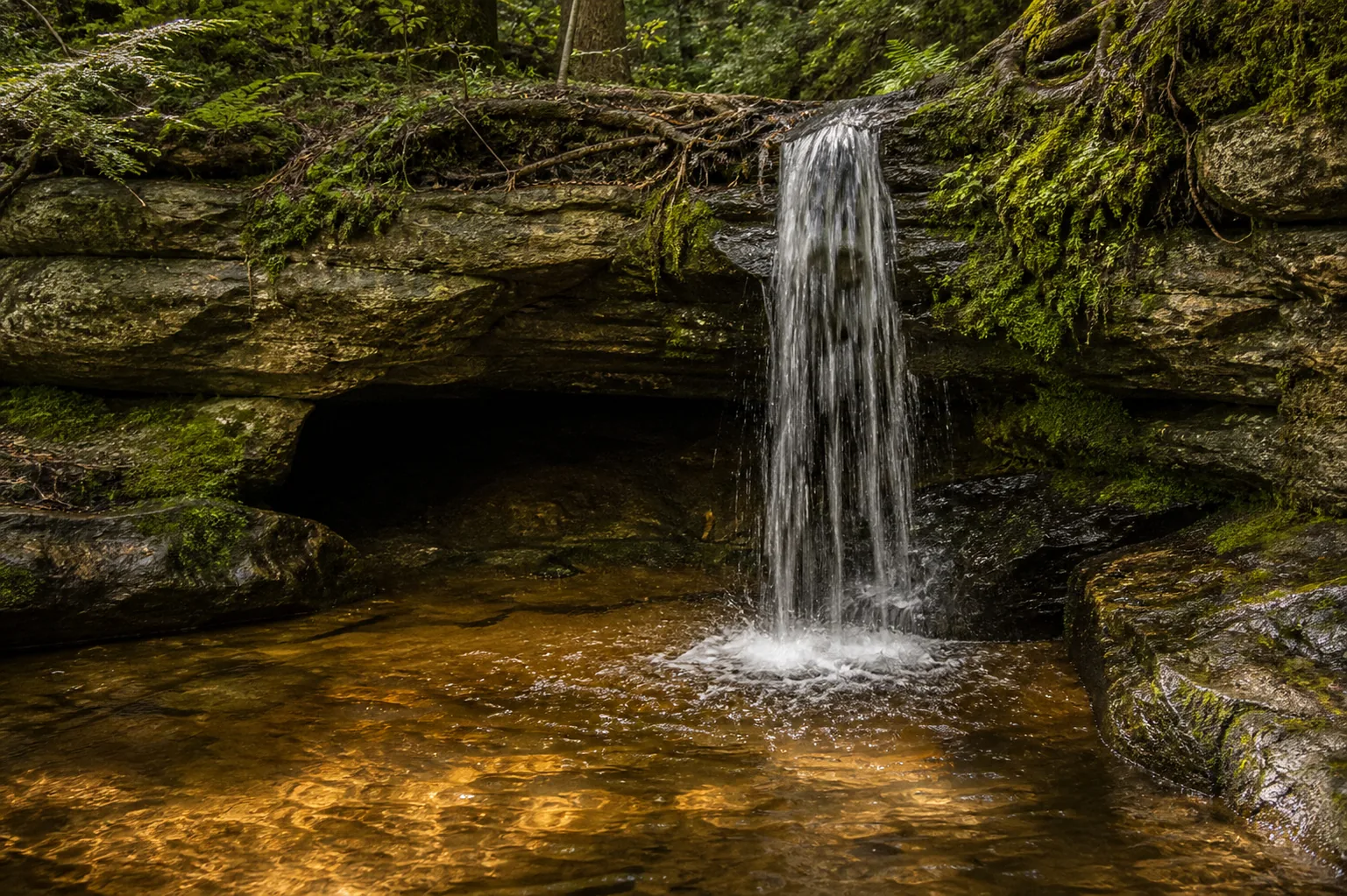
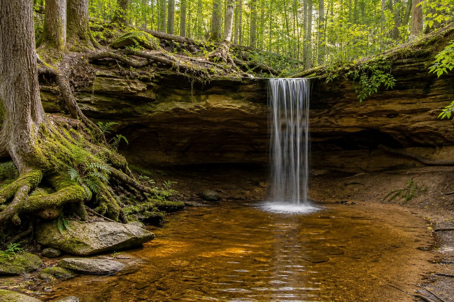
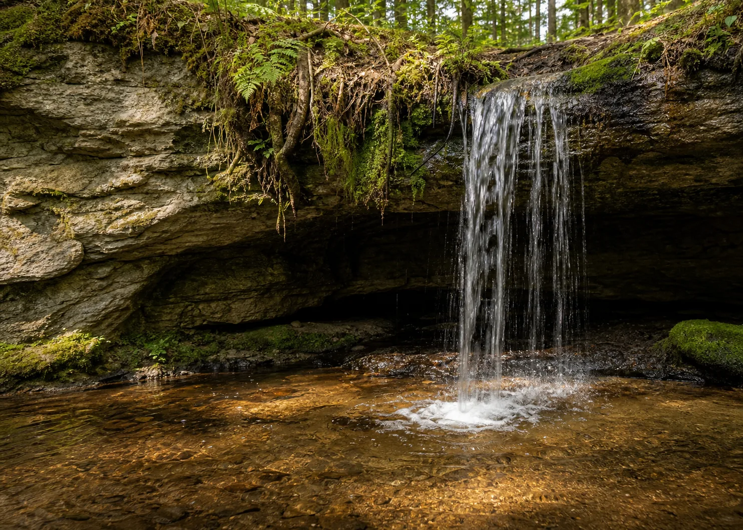
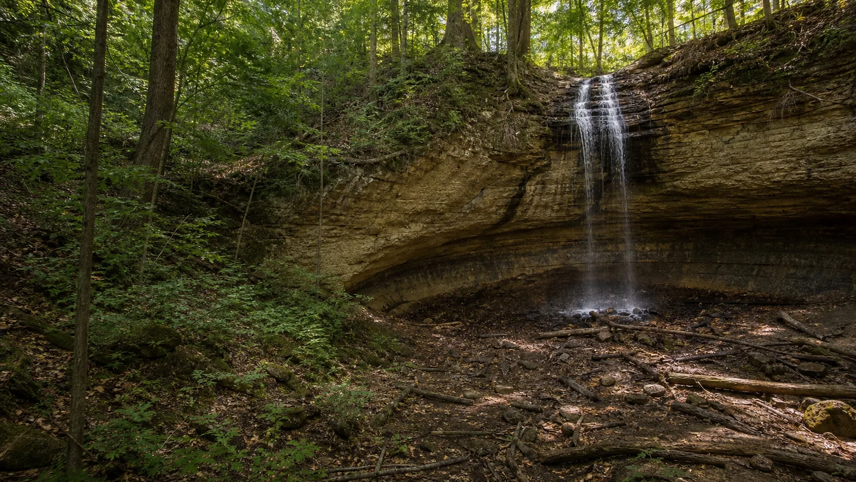
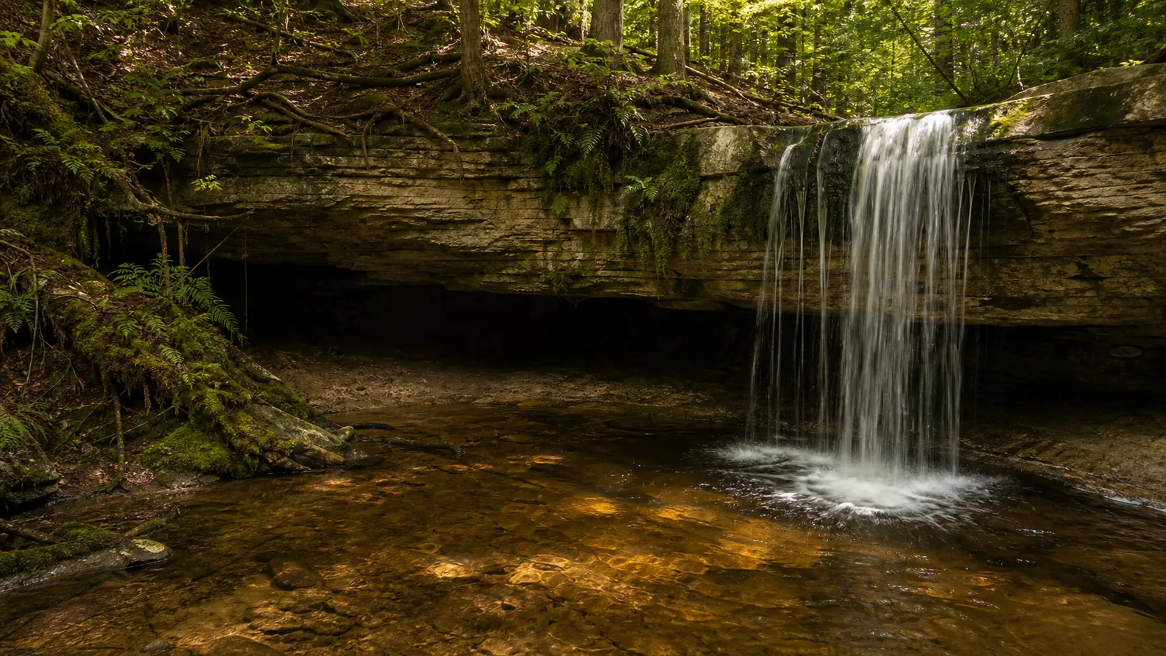
Yes, especially as a five-minute stop on the M-28 drive between Munising and Marquette. The falls runs year-round on Scott Creek, the trail is literally across the road from the parking pull-off, and the sandstone alcove behind the curtain is one of the few walk-behind waterfalls in Michigan that does not require a hike. Best flow is late April through May during snowmelt. Best photos are overcast spring mornings or late October when the maple ridge above the falls turns. In deep winter the curtain freezes into a translucent ice column visible from the road.

  • 20-foot single-tier plunge on M-28
  • Walk-behind sandstone alcove
  • Free roadside parking (Rathfoot Park)
  • Year-round access, plowed highway
  • Peak flow: late April through May
  • Pictured Rocks region waterfall day
Last verified May 12, 2026 Visited Desk-verified May 2026 8 sources checked
Distance 0.1 mi 0.2 mi extended
Round trip 5-20 min Cross M-28 on foot, then a flat 50-foot dirt path to the alcove
Difficulty Easy Cross M-28 on foot, then a flat 50-foot dirt path to the alcove
Location Au Train Township, MI H.J. Rathfoot Roadside Park
Parking Free roadside park (H.J. Rathfoot) on the north side of M-28; cross the highway on foot to reach the falls MDOT / Hiawatha NF
Transit No fixed-route transit Drive M-28 to the H.J. Rathfoot Roadside Park pull-off · 100 ft
Drive 10 mi 15 min from downtown
Best season Year-round; spring melt is loudest Late April through May (snowmelt)
Scott Falls curtain dropping into the sandstone alcove
Photo guide

Four angles of a 20-foot roadside waterfall.

Four photographer-tested viewpoints around Scott Falls, arranged the way you would actually walk them: wide context from the Rathfoot pull-off, head-on from the splash apron, back-out-through-the-curtain from inside the alcove, and the canopy frame from the north shoulder of M-28.

Scott Falls 20-foot single-tier waterfall on M-28 with the Munising sandstone walk-behind alcove
Scott Falls, hero composition
Scott Falls wide setting in the Pictured Rocks region along M-28 in Au Train Township
Wide setting along M-28 in Au Train Township
Scott Falls 20-foot curtain dropping into the Munising Formation sandstone alcove
Curtain dropping into the sandstone alcove
Scott Falls walk-behind view inside the Cambrian sandstone alcove undercut
Walk-behind view of the Cambrian sandstone undercut
01Is Scott Falls flowing right now?

There is no USGS gauge on Scott Creek. Use the National Weather Service Marquette office (MQT) forecast for recent precipitation, and assume snowmelt timing of late April through mid-May in normal years.

Scott Creek is short, ungauged, and entirely dependent on local snowpack and rainfall. Peak flow runs late April through May during snowmelt; by late summer the creek can drop to a thin ribbon split across the lip. After a heavy summer thunderstorm the falls can return to full curtain within hours.

02How long is the walk?

About 50 feet of dirt path from the south shoulder of M-28 to the base of the alcove. Add the highway crossing and you are at the curtain in two minutes from your car.

03How do you get there?

From Munising, drive west on M-28 for about 10 miles. The H.J. Rathfoot Roadside Park pull-off is on the north (right) side of the road; the falls is directly across the highway on the south side. From Marquette, take M-28 east for about 40 miles; the pull-off is on the south side of the road and the falls is on the north as you approach.

04Is there free parking?

Free roadside parking at H.J. Rathfoot Roadside Park on the north side of M-28. The lot is plowed in winter but the shoulder ices over, so leave a generous buffer to the traffic lane. The pull-off fills on summer weekends because every Munising-to-Marquette road tripper stops here for two minutes.

05Does it cost money?

Free. No parking fee, no day-use fee, no state-park pass, no federal-lands pass.

06Trail variants

Quick roadside view from your car, 2 min, visible through the trees from the pull-off.
Walk-behind 0.1 mi out-and-back, 5-10 min, cross M-28 carefully, step into the sandstone alcove behind the curtain.
Rathfoot Park stop park grounds, 15-30 min, picnic tables and restrooms on the north side of M-28.
Pictured Rocks waterfall day drive itinerary, half-day, pair with Munising, Miners, and Tannery Falls 10-15 miles east.

Detailed maps and recent reviews: Falls route on AllTrails · Creek route on AllTrails

07Can you swim?

The plunge pool is shallow and filled with fallen sandstone slabs from the alcove ceiling, which is not a swimming hole. Au Train Lake (two miles north) and the Lake Superior beach at Bay Furnace (six miles east) are the local swim spots.

08Are dogs allowed?

Dogs are welcome on leash. The falls sits about 50 feet from a live two-lane highway with no shoulder fence; a short leash is required, not optional.

09Is it accessible?

The roadside pull-off is paved. The falls is visible from the pull-off for those who cannot cross M-28 safely. The 50-foot dirt path on the south side is flat but uneven and not ADA-compliant.

Field notes

Scott Falls at a glance.

20-foot single-tier plunge over Munising Formation Cambrian sandstone, on the south side of M-28 in Au Train Township, Alger County. Free roadside park, year-round access, no permits.

Height 20 ft USGS 3DEP
Type Plunge (single tier) USGS
Rock Munising Formation sandstone (Cambrian) Michigan Geological Survey: Munising Formation (Cambrian sandstone)
County Alger Au Train Township, MI
Managed by Michigan Department of Transportation roadside park, adjacent Hiawatha National Forest MDOT / Hiawatha NF
Water source Scott Creek USGS
Elevation 636 ft USGS NED
Park area Not listed MDOT / Hiawatha NF
Hours Roadside pull-off; open 24 hours, year-round (no gate) MDOT / Hiawatha NF
When to visit

Two windows that show the falls at its best, one for the ice column.

Late April through May for the loudest spring snowmelt. Mid-October for fall color on the maple ridge above the lip. Late January through February for the translucent ice column visible from the highway. The rest of the year the falls reads as a thinner curtain or a streak, which is still fine for a five-minute stop.

PEAK FLOW

Peak flowLate April through May (snowmelt)
Ice / low flowJanuary through March (ice column)
Most crowdedWeekends and midday
Best photosSunrise or weekdays

Live water context

Discharge data -- There is no USGS gauge on Scott Creek. Use the National Weather Service Marquette office (MQT) forecast for recent precipitation, and assume snowmelt timing of late April through mid-May in normal years.

Why is it called Scott Falls?

Scott Falls and its companion roadside park are named for the Scott family, among the earliest settlers of the Au Train Township area in the second half of the 19th century. The adjacent park carries the H.J. Rathfoot name from a later highway-era dedication. The creek that feeds the falls is Scott Creek, a short tributary that drains the wooded ridge between M-28 and the Au Train River corridor before dropping over the sandstone ledge a few hundred feet from Lake Superior's nearshore basin. The waterfall does not appear on early French or Ojibwe maps under any other documented name; like many smaller M-28 falls, it picked up its identity from the family that lived near it.

What else to do at H.J. Rathfoot Roadside Park

Scott Falls sits inside the Hiawatha National Forest corridor along M-28, in the Pictured Rocks region of Michigan's Upper Peninsula. The roadside park (H.J. Rathfoot Roadside Park) is an MDOT pull-off on the north side of the highway with picnic tables, restrooms, and a Lake Superior view; the falls is on the south side, set back about 50 feet into the trees. Au Train Lake (Hiawatha NF, with a swim beach and campground) is two miles north. Munising is 10 to 15 miles east depending on which end of town you measure to, and the Munising waterfall cluster (Munising Falls, Miners Falls, Tannery Falls, Wagner Falls) all sit within a 20-minute drive of Scott. Marquette is about 50 miles west.

  • H.J. Rathfoot Roadside Park. Free MDOT pull-off on the north side of M-28 with picnic tables, restrooms, and a Lake Superior view across the highway from the falls.
  • Walk-behind alcove. The Munising sandstone undercut produces an open amphitheater behind the curtain. You can step into it from either side at low to moderate flow.
  • Year-round access. M-28 is plowed year-round and the pull-off stays open in winter. The curtain freezes into an ice column in January and February.
  • Au Train Lake corridor. Two miles north on Au Train Forest Lake Road, with a Hiawatha National Forest beach, campground, and the Au Train Songbird Trail.
  • Pictured Rocks cluster. Munising, Miners, Tannery, and Wagner Falls all sit within 20 minutes east; the Pictured Rocks cliffs are 15 miles east.

Why it looks this way

Scott Falls drops over the Munising Formation, a Cambrian sandstone that runs along the Lake Superior shoreline from Au Train east through Munising and into Pictured Rocks National Lakeshore. The same formation forms the painted cliffs at Miners Castle and the alcove behind Munising Falls. At Scott Falls the upper sandstone is harder and more cemented than the layers underneath, so the creek wears the softer rock away faster than the lip and the ledge overhangs. That undercut produces the open amphitheater behind the curtain. The pool below collects fallen slabs from the alcove ceiling, which is why the floor is slick and uneven and why the alcove gets a little deeper every century.
Field guide deep dive

What you cannot tell from a Tripadvisor listing.

How the Munising sandstone produces the alcove, why the walk-behind is so easy, and how Scott Falls fits into a Pictured Rocks waterfall day. Skim the headers, read what you need.

How Scott Falls formed

Scott Falls drops over the Munising Formation, a Cambrian sandstone laid down roughly 500 million years ago along the southern edge of an ancient inland sea. The same formation forms the painted cliffs at Miners Castle in Pictured Rocks National Lakeshore, the alcove behind Munising Falls, and the lip of Miners Falls on the Miners River 15 miles east.

At Scott Falls the geology produces a textbook undercut. The upper sandstone is more heavily cemented and resists erosion. The lower layers, which include thin shaley partings, weather faster. The creek wears the softer rock away first, the harder cap overhangs, and the alcove behind the curtain grows a little wider every century. Slabs from the alcove ceiling occasionally let go and land in the plunge pool, which is why the pool floor is uneven and why the alcove is taller behind the lip than the drop itself measured from the splash apron.

The drop is small (about 20 feet visible from the apron, with the recognized straight-drop component closer to 10 feet over the lip) because Scott Creek is short and the elevation difference between the ridge above M-28 and Lake Superior is modest. The interest is not the height, it is the alcove geometry.

Why the walk-behind is so easy

Most walk-behind waterfalls require a hike, a stair descent, or both. Scott Falls is the opposite. The parking pull-off at H.J. Rathfoot Roadside Park sits on the north side of M-28. The falls sits on the south side, 50 feet back from the pavement, in a shallow rock bowl carved into the Munising sandstone. There is no trail in the usual sense, just a short dirt path through the trees from the highway shoulder to the splash apron.

Once you are at the base, the alcove opens behind the curtain on both sides. At low to moderate flow you can step into it without getting more than your shoes wet. The floor is sandstone with fallen slabs from the ceiling, which is slick when wet, so traction soles help. Spring runoff sometimes pushes spray far enough that the alcove floor gets a constant misting, and after heavy summer thunderstorms the falls can briefly run too hard for the walk-behind to be comfortable. Pick your moment by reading the curtain from the pull-off before crossing.

One real hazard that is not the falls itself: M-28 is a state highway carrying steady summer traffic between Munising and Marquette. There is no marked crosswalk and no traffic light. Cross from the pull-off the way you would cross any rural state highway: in daylight, with sightlines clear in both directions, and never with small children unattended.

A Pictured Rocks waterfall day from Scott Falls

Scott Falls is a five-minute stop, not a destination. The way to spend the rest of the day is east, into the Munising waterfall cluster. Drive M-28 east for 10 miles to Munising and pick up the cluster in any order:

Munising Falls is the headline. A 50-foot ribbon plunges over the same Munising Formation sandstone into a deeper alcove than Scott's, with a paved interpretive trail managed by the National Park Service as part of Pictured Rocks National Lakeshore. Miners Falls on the Miners River is 15 miles east of Munising, a 0.6-mile gravel trail to a wooden viewing platform overlooking a 40-foot plunge through a forested gorge. Tannery Falls sits inside the city limits of Munising and drops a tall narrow ribbon down a moss-covered cliff face that you reach from a short stairway off a residential street.

That is four waterfalls on the same Cambrian sandstone in under 25 miles of driving, all free, all reachable inside half a day. If you have more time, add Wagner Falls (a 20-foot plunge a mile south of Munising on M-94) and Au Train Falls (a small cascade on the Au Train River a few miles north of Scott Falls).

The simple roadside access

Scott Falls is one of the easiest waterfalls to visit in the entire Upper Peninsula. There is no trailhead, no permit, no fee, no ranger station, no map kiosk. You drive M-28, you see the H.J. Rathfoot Roadside Park sign, you pull off, you cross the road, you are there. The pull-off has picnic tables and restrooms for the family-road-trip version of the stop, and a Lake Superior view across the road in the other direction.

The simplicity is also the catch. Because the stop is unmanaged in the usual park sense, the only access checks are common sense: the highway shoulder is the parking, the dirt path is the trail, and the alcove floor is wet sandstone. There is no railing, no posted height marker, no signed warning about slick rock. Treat it like any small Upper Peninsula waterfall: stay back from the lip if you walk up to it from above (most visitors do not), wear shoes with traction, and assume the rock is slippery whenever it is wet.

Winter access works the same way. M-28 is a federally designated all-weather route and the Michigan Department of Transportation plows it year-round. The pull-off stays open. The falls freezes from late December through early March in most years, and the curtain becomes a translucent ice column with running water continuing underneath. Photograph it from the pull-off; do not try to walk behind a frozen falls because the alcove floor is sheet ice and the ceiling can shed slabs without warning.

Au Train Township and the Hiawatha National Forest

Scott Falls sits in Au Train Township in Alger County, on the southern edge of the Hiawatha National Forest. The township is small, mostly forested, and oriented around the Au Train River and Au Train Lake corridor. The unincorporated village of Au Train is a mile north of the falls along Au Train Forest Lake Road, with a general store, a handful of cabins for rent, and a Hiawatha National Forest campground at the south end of Au Train Lake.

The lake itself is the local recreation anchor. Two miles north of Scott Falls you reach the Au Train Lake Recreation Area, a Hiawatha National Forest site with a sandy swim beach, picnic facilities, and the Au Train Songbird Trail (a 2-mile loop maintained for warbler and thrush habitat). The Au Train River connects the lake to Lake Superior at Au Train Beach about a mile west of Scott Falls; the beach is a quiet alternative to the busier Lake Superior frontage at Munising.

Practical context for trip planning: Munising is 10 to 15 miles east on M-28, with grocery, fuel, lodging, and the Pictured Rocks Cruises dock. Marquette is 50 miles west on M-28, with a regional airport (MQT), full-service lodging, and the closest car-rental hubs. The nearest gas stations to Scott Falls are in Au Train (north) and Christmas (east, on the way to Munising).

Photography practical: north-facing curtain, four positions

The curtain at Scott Falls faces roughly north, which means direct sun on the water is rare and overcast light is the default. That is good news for waterfall photography because overcast holds detail in both the white water and the dark sandstone alcove without blowing out the highlights. The four working positions:

Position 1: roadside pull-off. Wide context with M-28 in the foreground and the falls in the trees across the road. The shot most people skip. Useful for trip recap and for showing the unusual proximity of the falls to the highway.

Position 2: splash apron head-on. The standard postcard frame. Cross M-28, take the 50-foot dirt path, set up at the base of the splash apron. Tripod is fine in shoulder season; in peak summer the apron gets crowded enough that handheld is faster.

Position 3: inside the alcove looking out. The walk-behind silhouette. Step into the alcove from either side at low to moderate flow, brace against the back wall, and frame the curtain from inside. The dark sandstone gives you a clean negative space around the white water.

Position 4: maple ridge above the lip. Late October only. Stand on the north shoulder of M-28 looking south and frame the falls with the orange and yellow canopy on the ridge above. The peak window is roughly the second and third weeks of October in normal years.

Map and route

Ten miles west of Munising on M-28.

From Munising, drive west on M-28 for about 10 miles. The H.J. Rathfoot Roadside Park pull-off is on the north (right) side of the road; the falls is directly across the highway on the south side. From Marquette, take M-28 east for about 40 miles; the pull-off is on the south side of the road and the falls is on the north as you approach.

Photography and weddings

North-facing curtain, four working positions, no permit required.

Four working positions. The roadside pull-off gives the wide context shot with M-28 in the foreground. Step across the highway and the head-on view from the splash apron is the standard postcard frame. Move into the alcove and shoot back out through the curtain for the walk-behind silhouette. The maple ridge above the falls is the late-October fall-color frame from the north shoulder of the road.

The falls faces north, so direct sun on the curtain is rare. Overcast spring mornings give the best detail in both the white water and the dark sandstone alcove. In late October, low afternoon light catches the orange and yellow canopy above the lip. Winter ice photographs cleanly under flat overcast.

Casual personal photography is free and unrestricted from the public pull-off and the path across M-28. Drone use over an active state highway is a bad idea even where federally legal; if you fly, set up away from the traffic lane and follow current FAA rules.

Permits

Weddings and engagements

Scott Falls works for engagement portraits and small ceremony photos, especially in shoulder season when M-28 traffic is lighter. There is no formal reservation system because it is a roadside park, not a dedicated venue.

No wedding permit is required for casual photos at H.J. Rathfoot Roadside Park, but the highway crossing means small groups only and no formal aisle setup in the alcove.

Plan around traffic, not crowds. Weekday mornings outside summer peak give you the alcove to yourself. Bring an umbrella for spring mist and traction soles for the wet sandstone.

Nearby waterfalls

Four Pictured Rocks waterfalls on one M-28 drive.

Scott Falls pairs naturally with the Munising waterfall cluster because all four sit within 20 minutes of each other and all four drop over the same Munising Formation sandstone. Start with Scott Falls, then drive east on M-28 to Munising Falls, Miners Falls, and Tannery Falls.

Related questions

More questions visitors ask before driving to Scott Falls.

Walk length, walk-behind, height, fees, parking, dogs, winter access, and worth-visiting. The full set is also indexed in the FAQ schema for AI answer engines.

01Can you walk behind Scott Falls?

Yes. The Munising Formation sandstone is undercut by Scott Creek, which produces an open alcove behind the curtain. You can step into it from either side at low to moderate flow. The floor is wet sandstone with fallen slabs, so wear shoes with traction, and avoid the alcove in winter when the floor ices over.

02How tall is Scott Falls?

The visible drop is about 20 feet including the lower splash apron. The recognized straight-drop component over the sandstone lip is closer to 10 feet, which is the number listed in Wikipedia and several local guides. Either way it is a small waterfall; the interest is the walk-behind alcove rather than the height.

03Is Scott Falls free to visit?

Yes, completely free. No parking fee, no day-use fee, no state-park pass required, no federal-lands pass required. The H.J. Rathfoot Roadside Park pull-off is a Michigan Department of Transportation roadside park, open 24 hours year-round with no gate.

04Where is Scott Falls?

On the south side of M-28 in Au Train Township, Alger County, Michigan, about 10 miles west of Munising in the Pictured Rocks region. Park at H.J. Rathfoot Roadside Park on the north side of the highway and the falls is directly across the road. From Marquette, drive about 40 miles east on M-28.

05Is Scott Falls open in winter?

Yes. M-28 is a federally designated all-weather route and the Michigan Department of Transportation plows it year-round. The H.J. Rathfoot Roadside Park pull-off stays open. The falls freezes from late December through early March in most years and forms a translucent ice column visible from the road. Photograph it from the pull-off; do not try to walk behind a frozen falls because the alcove floor is sheet ice.

06Is Scott Falls worth visiting?

Yes, as a five-minute stop on the M-28 drive between Munising and Marquette. The combination of roadside access, walk-behind alcove, and Pictured Rocks regional setting makes it one of the most efficient waterfall stops in Michigan. It is not a destination on its own but pairs naturally with Munising Falls, Miners Falls, and Tannery Falls for a half-day waterfall loop.

Sources and data

Where the Scott Falls guide gets its facts.

Munising Visitors Bureau for location and roadside-park context. Hiawatha National Forest pages for the Au Train Lake corridor. Michigan Geological Survey for the Munising Formation sandstone. NOAA / NWS Marquette office (MQT) for climate and precipitation.

MDOT / Hiawatha NF: H.J. Rathfoot Roadside Park munising.org
Access, parking, and permit rules: munising.org
Michigan Geological Survey: Munising Formation (Cambrian sandstone): Au Train Township bedrock michigan.gov
NOAA / NWS Marquette forecast grid MQT/173,66 noaa.gov
USGS National Elevation Dataset 3DEP
Google Maps: embedded map and directions maps.google.com
Google Places: nearby restaurants and hotels places API
Munising Visitors Bureau: Scott Falls munising.org
Wikipedia: Scott Falls en.wikipedia.org
Hiawatha National Forest: Au Train Lake Recreation Area fs.usda.gov
Pictured Rocks National Lakeshore (NPS) nps.gov
Wikimedia Commons: Scott Falls images commons.wikimedia.org
Michigan Department of Transportation: M-28 corridor michigan.gov/mdot
Fact checks
Geology audit: rock is Munising Formation, a Cambrian sandstone confirmed across the Michigan Geological Survey description of the Lake Superior shoreline corridor from Au Train through Pictured Rocks National Lakeshore. The same formation forms Miners Castle and the alcove at Munising Falls.
Height audit: Wikipedia and several local guides list the drop as 10 feet over the sandstone lip; regional guides and on-site impressions report the visible total drop including the splash apron at closer to 20 feet. This guide uses 20 feet as the visible total drop, with the 10-foot lip number acknowledged in the long-form geology section.
Access audit: roadside parking is free at H.J. Rathfoot Roadside Park (MDOT), the falls is on the south side of M-28 across from the pull-off, and walk-behind access is consistent across the Munising Visitors Bureau, Tripadvisor, and Michigan road-trip references.
Etymology audit: the falls is named for the Scott family, early Au Train settlers; the adjacent park carries the H.J. Rathfoot dedication from the highway era. No documented Ojibwe or French alternative name has been found.
Walk-behind audit: the alcove is open on both sides at low to moderate flow and informally accessible year-round; the alcove floor ices over December through March and the walk-behind is not safe in deep winter.
Photo audit: AI-original pack grounded in the local verified reference set (hero, main view, pool and rock detail, wide setting); no unrelated waterfall images are used in waterfall slots.
Corrections: [email protected]