Port Angeles, Washington
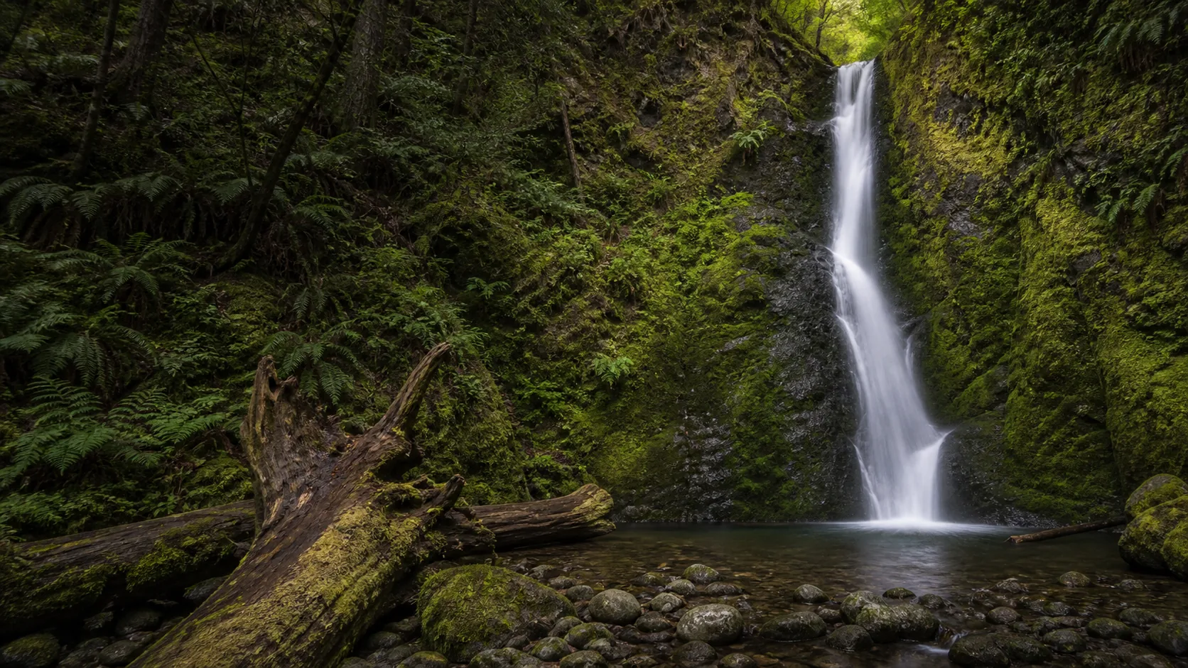
Madison Creek Falls
Plan Madison Creek Falls near Port Angeles, Washington: 0.2 mi route details, parking and directions, best time to visit, safety notes, and 4 waterfall photos.
50 ft0.2 mi4 photos
Practical guides to three Washington waterfalls, from a fully accessible Olympic National Park horsetail to an 88-foot Mt Baker Highway plunge with a live USGS gauge. Verified entrance fees, trail lengths, dog rules, and seasonal access against NPS, USFS, USGS, and Washington Trails Association sources.
Washington is one of the country's deepest waterfall states, with hundreds of named falls spread across the Olympic Peninsula, the North Cascades, Mount Rainier, the Columbia River Gorge's north bank, and the Palouse channeled scablands. The Northwest Waterfall Survey's Washington index lists well over 600 named drops, and the headline names are familiar even to people who have never visited the state: 268-foot Snoqualmie Falls east of Seattle, 200-foot Palouse Falls in the eastern wheat country (Washington's official state waterfall), Wallace Falls and Twin Falls on the I-90 corridor, Bridal Veil Falls in the central Cascades, Comet Falls in Mount Rainier National Park, and Sol Duc Falls on the wet west side of Olympic. Washington's tallest measured drop, Colonial Creek Falls in North Cascades National Park at roughly 2,584 feet, is among the tallest in the contiguous United States.
The three Washington waterfall guides published on Waterfalls Guide today cover two of the state's strongest regional clusters. Madison Creek Falls and Marymere Falls are both inside Olympic National Park, drop over Crescent Formation basalt and marine sedimentary rocks, and share the same $30 per-vehicle / 7-day Olympic NP entrance fee. Madison Falls is a 50-foot horsetail with a fully paved 0.2-mile ADA-accessible trail in the Elwha Valley; Marymere is a 90-foot horsetail reached by a 1.8-mile round-trip walk through old-growth Douglas-fir on the south shore of Lake Crescent. Nooksack Falls sits on the opposite side of the state on the Mt Baker Highway, an 88-foot twin-chute plunge into a basalt gorge inside the Mt Baker-Snoqualmie National Forest with a live USGS discharge gauge (median 625 cfs) and no entry fee.
The hub intentionally surfaces what is not yet covered, because the gap matters: Snoqualmie, Palouse, Twin, Bridal Veil, Wallace, Comet, and Sol Duc all sit outside the three guides below. Each Washington guide we have published carries practical access detail (trail length, parking fees, dog rules, winter access) verified against the National Park Service, U.S. Forest Service, Washington Trails Association, and USGS sources.
A 50-foot horsetail in Olympic National Park's Elwha Valley reached by a fully paved, ADA-accessible 0.2-mile trail. Wheelchair- and stroller-friendly, 15 to 30 minutes round trip, 9 miles west of Port Angeles.
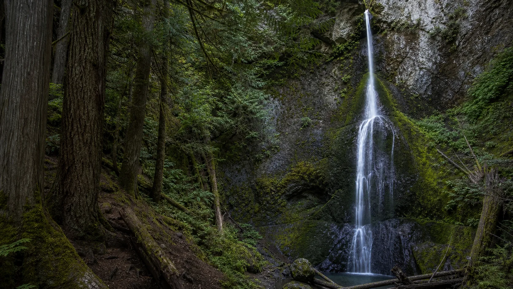
A 90-foot horsetail above Lake Crescent reached by a 1.8-mile round-trip walk through old-growth Douglas-fir from the Storm King Ranger Station. Pairs with the lakeshore and the Lake Crescent Lodge.
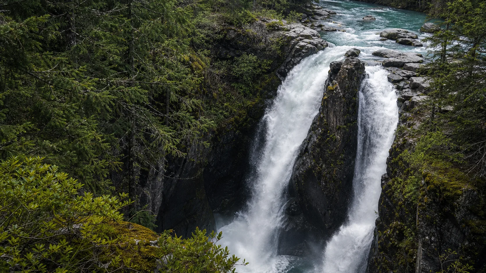
An 88-foot twin-chute plunge into a basalt gorge on the North Fork Nooksack River off the Mt Baker Highway. Free, 0.1-mile walk to a fenced overlook, paired with a live USGS gauge (median 625 cfs) since 1996.
Washington waterfalls run on two clocks. The wet west-side falls (Madison Creek, Marymere, and most of the Olympic Peninsula and Columbia Gorge) are rain-driven and peak November through April, with the loudest flow typically in late December and January after a stacked Pacific atmospheric-river week. Snowmelt-fed Cascade falls, including Nooksack on the Mt Baker Highway, peak late May through June as the North Cascades and Mount Baker snowpack drains; Nooksack's gauge typically runs above its 625 cfs median through that window and can spike above 1,640 cfs (the 90th percentile) during heavy melt.
Two access constraints worth planning around. The Mt Baker Highway (WA-542) is plowed only to the town of Glacier in winter, which leaves the Nooksack Falls overlook reachable but the road beyond the falls closed; the upper highway to Picture Lake and Artist Point typically reopens in late June or early July. Olympic National Park's low-elevation roads to the Madison Falls Trailhead and the Storm King Ranger Station stay open year-round in normal winters, though atmospheric-river storms can close US-101 for short windows. Fall color through October is excellent at all three covered falls, with bigleaf maple at Madison and Marymere and a mix of vine maple and red cedar at Nooksack.
Two Olympic NP falls covered here, both over Crescent Formation basalt and marine sedimentary rock that forms the structural ring of the peninsula. Madison Creek Falls is the most accessible waterfall in the park (0.2 mi paved); Marymere Falls is a 1.8-mile round-trip from Lake Crescent. Both sit inside the same $30 / 7-day entrance fee, and dogs are not allowed on either trail under Olympic NP regulations. Sol Duc Falls about 75 minutes west is the natural third stop for an Olympic waterfall day; we have not yet published a verified Sol Duc guide.
Nooksack Falls is the most visible roadside cascade on WA-542 east of Bellingham, an 88-foot plunge over basalt and andesite of the Chilliwack composite into a tight gorge with a fenced overlook. Mt Baker-Snoqualmie National Forest land, no entry fee, dogs generally allowed on leash. The North Cascades and Mt Baker region also hold Picture Lake, Artist Point, and the Heliotrope Ridge approach to Mount Baker for a fuller summer day, all reached by continuing east on the Mt Baker Highway when the upper road is open in summer.
Washington has more than 600 named waterfalls, per the Northwest Waterfall Survey index, plus several thousand unnamed drops if you include the wettest North Cascades and Olympic drainages. The state's tallest measured waterfall is Colonial Creek Falls in North Cascades National Park at roughly 2,584 feet across multiple tiers, among the tallest in the contiguous United States. The most visited falls are Snoqualmie Falls (268 ft) east of Seattle and Palouse Falls (200 ft) in the eastern Palouse channeled scablands, which is Washington's official state waterfall. Waterfalls Guide currently publishes three verified Washington guides and is expanding coverage as additional falls are field-checked.
Colonial Creek Falls in North Cascades National Park is the tallest measured waterfall in Washington, dropping roughly 2,584 feet across multiple tiers on the slopes of Snowfield Peak above Diablo Lake. It is one of the tallest waterfalls in the contiguous United States, but it has no formal trail and is generally viewed from across Diablo Lake or from the air. Among the more accessible Washington falls, Comet Falls in Mount Rainier National Park (320 ft), Sol Duc Falls in Olympic National Park (50 ft three-channel), and Snoqualmie Falls outside Seattle (268 ft) are the standard headline names. Among the three falls covered on this hub, Marymere Falls is the tallest at 90 feet.
It depends on which side of the state and which water source. West-side and Olympic Peninsula falls (Madison Creek, Marymere, Sol Duc, Snoqualmie) are rain-driven and peak November through April, with late December and January as the loudest window after Pacific atmospheric-river storms. Cascade snowmelt falls (Nooksack, Comet, Bridal Veil, Wallace) peak late May through June. Fall color through October is excellent statewide, especially mid-October bigleaf maple on the Olympic Peninsula. Plan around two specific access windows: the Mt Baker Highway beyond Nooksack Falls is closed by snow from roughly November through late June, and Olympic NP roads are low-elevation enough to stay open year-round in normal winters.
It depends on which agency manages the land. The two Olympic National Park falls covered here (Madison Creek, Marymere) sit inside the park's $30 per private vehicle / 7-day entrance fee, also covered by the $80 America the Beautiful annual pass and the senior, military, and access passes. Nooksack Falls is on Mt Baker-Snoqualmie National Forest land with no entry fee and no Northwest Forest Pass requirement at the trailhead lot. Outside this hub, Snoqualmie Falls is free (Puget Sound Energy operates the viewpoint), Palouse Falls requires the Washington Discover Pass ($10 day-use or $30 annual), and most Cascade trailhead lots on USFS land require a Northwest Forest Pass ($5 daily or $30 annual).
It depends on the land manager. Dogs are not allowed on Olympic National Park trails under standard NPS regulations, which rules out both Madison Creek Falls and Marymere Falls. Olympic NP pets are restricted to roads, parking areas, campgrounds, and a small set of designated pet-allowed beaches. Mt Baker-Snoqualmie National Forest is generally dog-friendly on leash, so Nooksack Falls allows leashed dogs on the trail and at the overlook. Mount Rainier National Park follows the same trail-ban rule as Olympic, so Comet Falls and other Rainier falls do not allow dogs on trail. Most Washington State Parks (Wallace Falls, Palouse Falls) allow leashed dogs on trail.
Nooksack Falls is paired with the USGS gauge at North Fork Nooksack River below Cascade Creek near Glacier, WA (12205000), about 1.5 miles upstream of the falls. The gauge has been running since 1996. Long-term median daily discharge is 625 cfs; the 75th percentile is 1,060 cfs and the 90th percentile is 1,640 cfs. Peak flows arrive in late May and June during Mount Baker snowmelt and again in November to December during atmospheric-river rain on snow. The maximum recorded discharge during the 1996 to 2026 period of record is 10,800 cfs. The Nooksack Falls guide on this site surfaces a live reading from the gauge.
The closest cluster to Seattle is the I-90 / Snoqualmie corridor, including Snoqualmie Falls (268 ft, 30 miles east), Twin Falls in Olallie State Park, and Franklin Falls. Wallace Falls State Park near Gold Bar is about an hour northeast on US-2 and holds a 367-foot three-tier cascade. The closest falls covered on this hub are Madison Creek Falls and Marymere Falls in Olympic National Park, both about three hours west of Seattle via the Bainbridge or Kingston ferry and US-101. Nooksack Falls is about two and a half hours north on I-5 and WA-542 toward Mt Baker. Waterfalls Guide has not yet published verified guides to the closer-in Seattle falls.
Plan Madison Creek Falls near Port Angeles, Washington: 0.2 mi route details, parking and directions, best time to visit, safety notes, and 4 waterfall photos.
Plan Marymere Falls in Clallam County, Washington: 1.8 mi route details, parking and directions, best time to visit, safety notes, and 8 waterfall photos.
Plan Nooksack Falls near Glacier, Washington: 0.1 mi route details, parking and directions, best time to visit, safety notes, and 8 waterfall photos.