Saint Paul, Minnesota
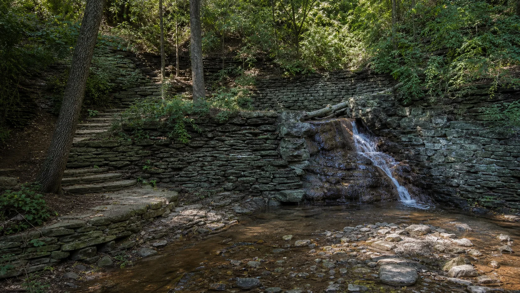
Hidden Falls
Plan Hidden Falls near Saint Paul, Minnesota: 1.4 mi route details, parking and directions, best time to visit, safety notes, and 7 waterfall photos.
18 ft1.4 mi7 photos
Most people who search for Minnesota waterfalls picture the North Shore: Gooseberry, High Falls, Cascade River, the Lake Superior basalt country. That coverage is on the roadmap but is not yet published on Waterfalls Guide. What is published right now is the other Minnesota waterfall story, and it is one of the better small-area geology stories in the country: three falls inside the Twin Cities, all on the same caprock contact, all reachable on one 90-minute loop.
Minnehaha Falls in south Minneapolis is a 53-foot plunge over Platteville Limestone into a St. Peter Sandstone amphitheater, two blocks from a Metro Blue Line stop. St. Anthony Falls a few miles north is the only true waterfall on the Mississippi River, a roughly 50-foot drop held in place today by a US Army Corps of Engineers lock-and-dam and a concrete spillway. Hidden Falls across the river in Saint Paul is an 18-foot drop in a wooded ravine that essentially marks Minnehaha's old position before 12,000 years of upstream retreat.
The throughline is mechanical. A hard band of Platteville Limestone caps each lip and a softer St. Peter Sandstone sits underneath. Water wears the sandstone away faster than the limestone, the limestone overhangs, then collapses, and the falls retreats upstream. St. Anthony has retreated about eight miles from its original position near Fort Snelling since glacial Lake Agassiz drained around 12,000 years ago. Minnehaha has done the same thing on a smaller creek, on a smaller scale, leaving the Hidden Falls site at the Mississippi confluence as its old position. Three falls, one mechanic, one geology lesson written into the city.
If you are headed to the North Shore for Gooseberry, High Falls at Grand Portage, or the Cascade River, the Minnesota DNR state-park pages remain the best reference until we publish those guides.
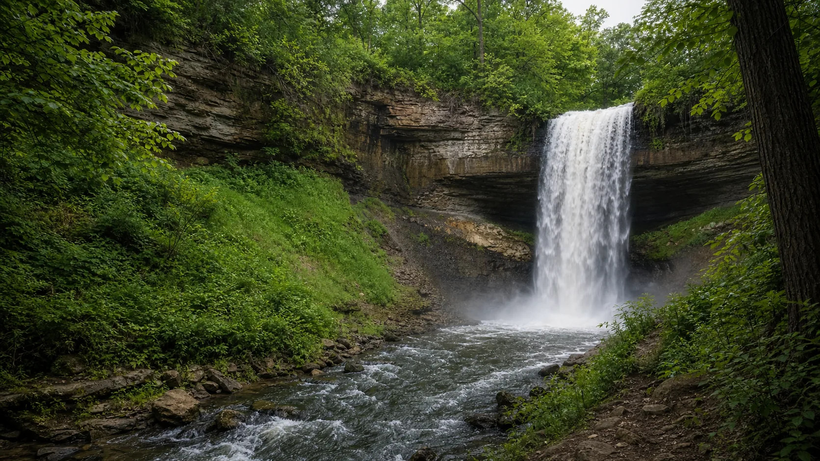
53-foot urban plunge in south Minneapolis, light-rail accessible, with a fully formed ice column in cold winters and the loudest spring runoff window in late April through May.
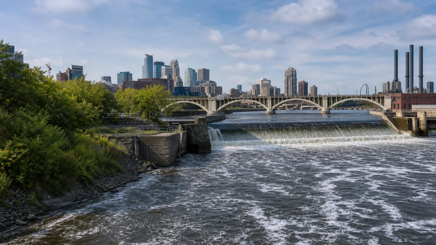
The only true waterfall on the Mississippi River. Viewed from the Stone Arch Bridge in downtown Minneapolis, now held in place by a lock-and-dam and concrete spillway after 12,000 years of upstream retreat.
An 18-foot drop in a wooded ravine on the Saint Paul side of the river. Basically Minnehaha's old position before 12,000 years of retreat. Free, year-round, almost never crowded.
Late April through May is the loudest window. Snowmelt and spring rain push Minnehaha Creek above the 75th-percentile USGS gauge reading of 83 cfs, often clearing 200 cfs on big melt days, which is when the falls reads as a full curtain instead of a thin streak. The Mississippi runs high through the same window, so St. Anthony's spillway and Hidden Falls both look their best in that stretch.
Late January through mid-February is the ice-column window. In a normal cold winter the entire 53-foot Minnehaha drop freezes into a hollow column with running water still audible inside it, typically completing in late January and holding through mid-February. The walk-behind-the-curtain route via the south stone stairs is only safe when the column is fully formed and the stairs are not iced over. In mild winters that route is unsafe and informally closed. Mid-October is the quieter third window for fall color in the gorge with manageable flow.
All three published Minnesota falls sit on the same Platteville Limestone over St. Peter Sandstone caprock contact, within a 30-minute drive of each other across the Minneapolis and Saint Paul sides of the lower Mississippi. Same caprock-undercut mechanic, three different scales: the urban-creek plunge (Minnehaha), the river-wide spillway (St. Anthony), and the side-channel remnant at the old Mississippi confluence (Hidden Falls). Total visit time for the loop runs about 90 to 120 minutes and the whole route is reachable on the METRO Blue and Green Lines.
Minnesota has dozens of named waterfalls, concentrated in two regions. The North Shore of Lake Superior holds the largest cluster, including Gooseberry Falls, High Falls at Grand Portage (the tallest in the state at 120 ft), Cascade River, and Tettegouche. The Twin Cities holds a much smaller but geologically distinct trio: Minnehaha, St. Anthony, and Hidden Falls. Waterfalls Guide currently publishes the three Twin Cities falls in full and points to Minnesota DNR resources for the North Shore.
Yes. The North Shore of Lake Superior is the largest waterfall region in Minnesota, with Gooseberry Falls, High Falls of the Pigeon River at Grand Portage, Cascade River, Tettegouche, and a long list of smaller named drops. These flow over Lake Superior basalt rather than the Platteville-sandstone caprock that produces the Twin Cities falls. Waterfalls Guide does not yet publish full North Shore guides; the Minnesota DNR state-park pages are the best current reference.
The Twin Cities waterfall trio is the cluster of three falls inside the Minneapolis-Saint Paul metro that share the same Platteville Limestone over St. Peter Sandstone caprock contact: Minnehaha Falls (53 ft, south Minneapolis), St. Anthony Falls (about 50 ft, downtown Minneapolis on the Mississippi), and Hidden Falls (18 ft, Saint Paul). All three are products of the same caprock-undercut mechanic and connect to one 12,000-year retreat history from the Mississippi after glacial Lake Agassiz drained.
The tallest waterfall in Minnesota is High Falls of the Pigeon River at Grand Portage State Park on the Canadian border, at about 120 feet. Waterfalls Guide does not yet publish a full High Falls guide; the Minnesota DNR Grand Portage State Park page is the current reference.
Minnehaha typically completes a full ice column in late January and holds through mid-February in a normal cold winter, after at least 10 consecutive days below freezing. The hollow 53-foot column has running water audible inside it from the lower deck. The walk-behind route via the south stone staircase is only safe when the column is fully formed and the stairs are not iced over; in mild winters or partial-freeze years it is unsafe and informally closed.
Yes. The trio sits within a 30-minute drive of each other, all three are free to enter, and all three are reachable on the METRO Blue and Green Lines. A typical Twin Cities waterfall day runs 90 to 120 minutes total: start at Minnehaha for the rim overlook and lower deck (30 to 45 min), drive 15 minutes north to St. Anthony Falls and the Stone Arch Bridge (20 to 30 min), then drop 10 minutes south across the river to Hidden Falls (20 to 30 min).
All three sit on the same caprock contact: a hard band of Platteville Limestone sitting on top of softer St. Peter Sandstone. Water wears the sandstone away faster than the limestone, the limestone overhangs, then collapses, and the falls retreats upstream a small amount each century. St. Anthony has retreated about eight miles since glacial Lake Agassiz drained around 12,000 years ago. Minnehaha has done the same on a smaller creek, leaving the Hidden Falls site at the Mississippi confluence as its old position.
Plan Hidden Falls near Saint Paul, Minnesota: 1.4 mi route details, parking and directions, best time to visit, safety notes, and 7 waterfall photos.
Plan Minnehaha Falls near Minneapolis, Minnesota: 0.9 mi route details, parking and directions, best time to visit, safety notes, and 8 waterfall photos.
Plan St. Anthony Falls near Minneapolis, Minnesota: 1.8 mi route details, parking and directions, best time to visit, safety notes, and 7 waterfall photos.