Three urban waterfalls along the Mississippi in Minneapolis and Saint Paul.
Three falls within seven miles of each other on the Mississippi River corridor through the Twin Cities. About 20 minutes of total driving, walkable and bikeable between the downtown stops.
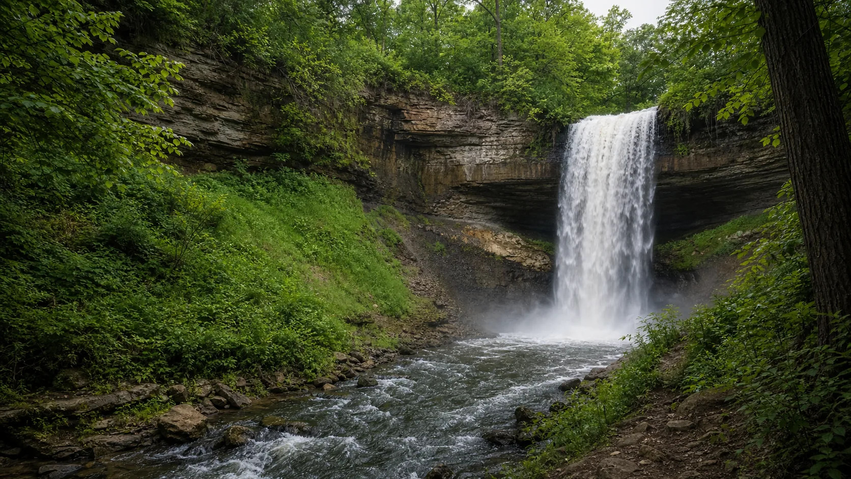
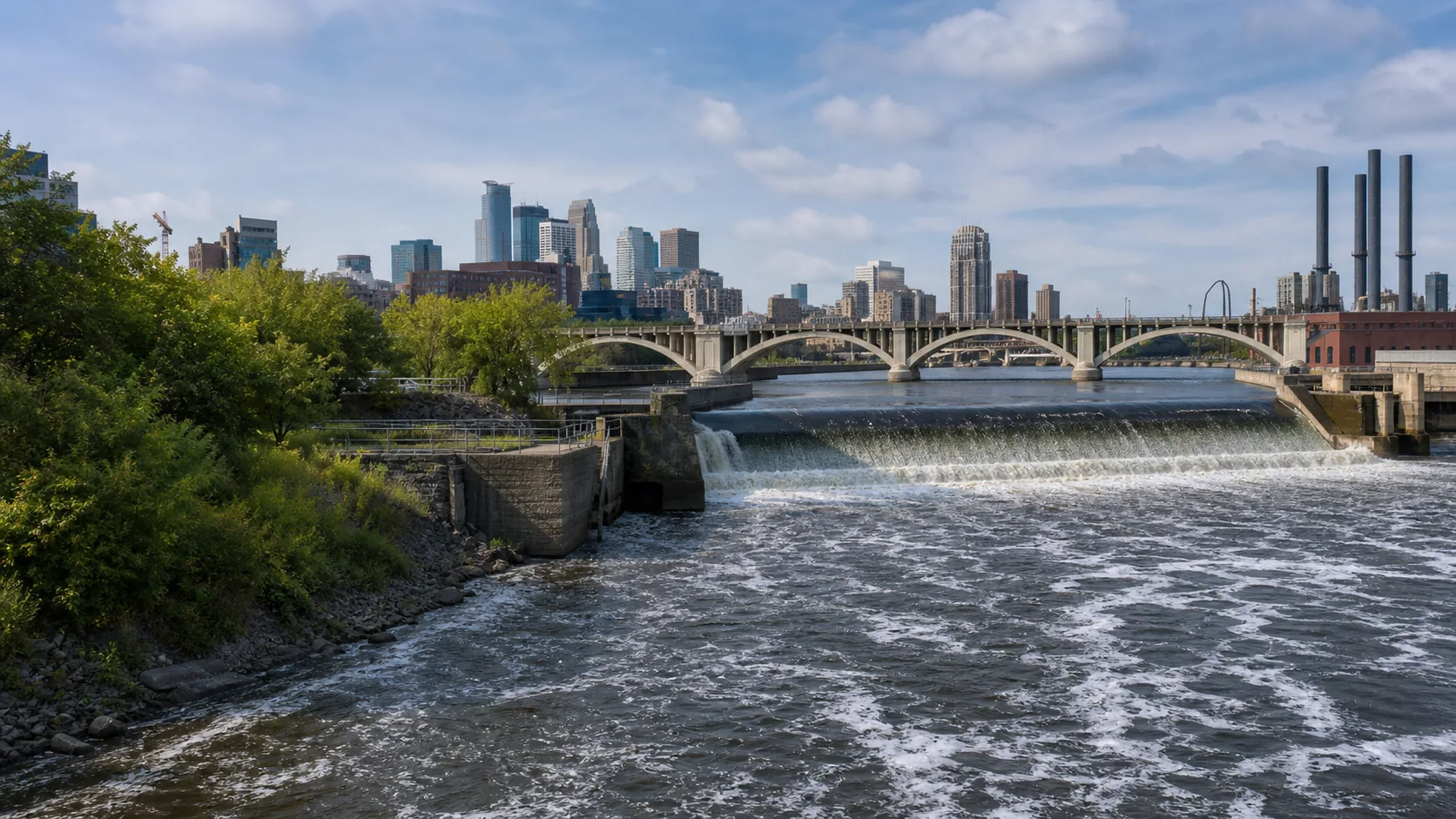
Few cities of any size have three named waterfalls inside the metro area. The Twin Cities have exactly that, all within seven miles of each other along the Mississippi River as it cuts from the Falls of St Anthony in downtown Minneapolis south past the Minnesota River confluence in Saint Paul. The geology is the underlying story: the Mississippi is incising through the soft St Peter Sandstone, capped by the resistant Platteville Limestone, and wherever a tributary creek meets the river there is a chance of a stepped plunge over the cap rock. Minnehaha Creek dropping into the Mississippi at Minnehaha Park is the classic case; the falls of St Anthony are the same geology on the main-stem river itself.
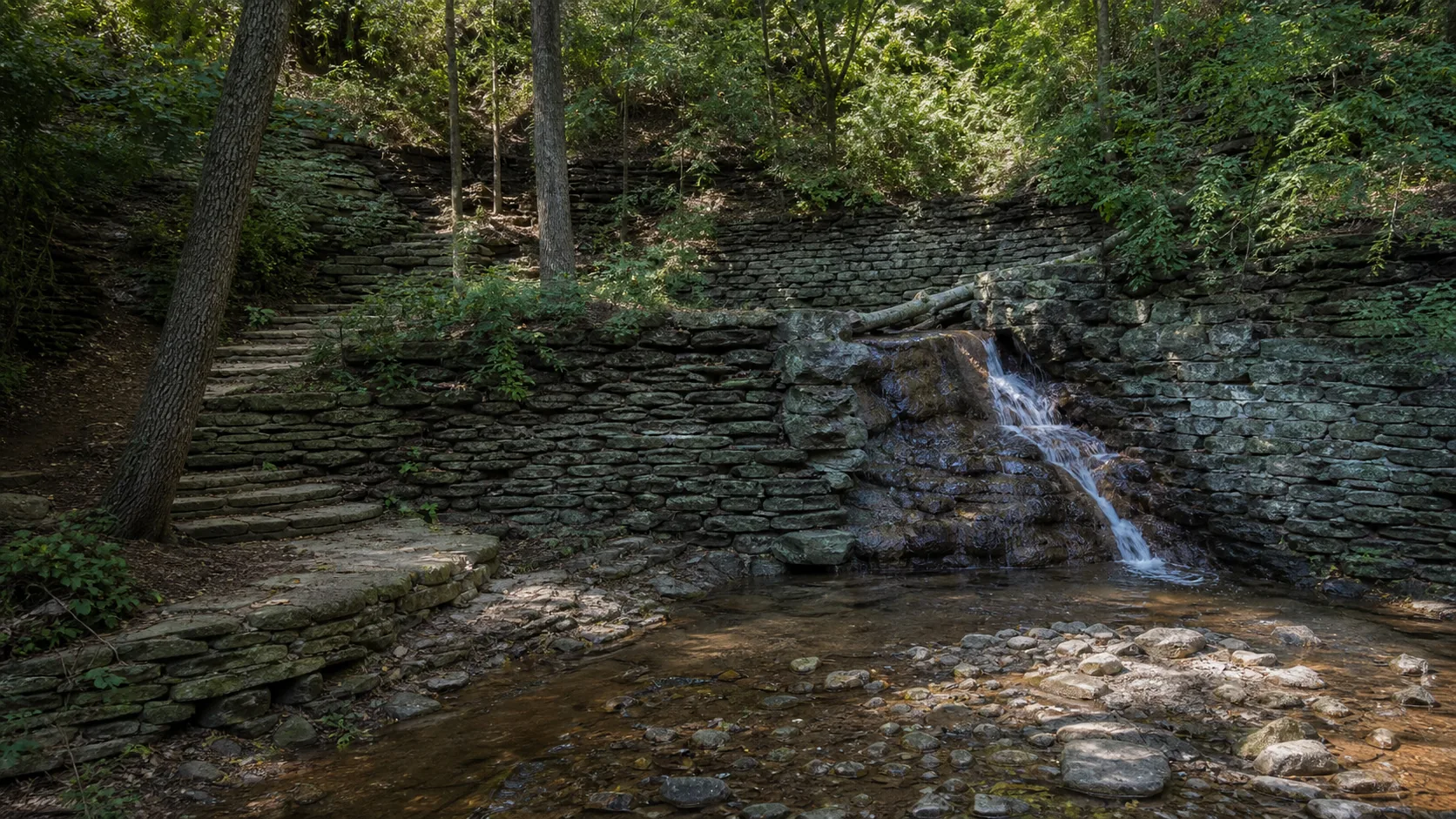
This route works as a half-day urban tour. Start at Minnehaha Falls in south Minneapolis, the 53-foot plunge over Platteville Limestone that Longfellow made famous, then drive 15 minutes north along West River Parkway to the Falls of St Anthony in downtown Minneapolis, the only major waterfall on the Mississippi and the geological reason Minneapolis exists where it does. Finish 20 minutes south at Hidden Falls Regional Park on the Saint Paul side of the river, a small unnamed creek dropping into the Mississippi near the confluence with the Minnesota River, the quietest of the three.
The total driving is about 20 minutes if you take West River Parkway between Minnehaha and St Anthony, slightly more if you cut north via I-94. The St Anthony to Hidden segment goes either via I-94 and W 7th Street (quickest) or down Summit Avenue past the Cathedral of Saint Paul (slower but the more scenic urban route). All three stops have free parking, public restrooms, and at least light food options on site or within walking distance.
Best suited to: Twin Cities residents looking for a half-day local tour, business travelers with a free afternoon downtown, parents with kids who want short walks plus playgrounds (Minnehaha Park has the region's best falls-adjacent playground), and out-of-state visitors who want to see why the Mississippi mattered to the milling history of Minneapolis.
Start at 9 a.m. before the south-Minneapolis park parking fills. Park in the Minnehaha Regional Park pay lot off Minnehaha Park Drive ($1.25 per hour). Walk five minutes to the 53-foot falls overlook, then descend the gorge trail past the falls to the Mississippi confluence (1.5-mile loop). Sea Salt Eatery in the old park pavilion does excellent fish tacos in season; the original Longfellow House is also on site. The Hiawatha light rail stops two blocks west of the park, making this stop transit-accessible from downtown. Best at high flow in late spring.
15 min · 5 mi from previous stop1 hr 15 min on site
Drive West River Parkway north along the Mississippi bluff into downtown Minneapolis. Park in the Mill Ruins Park lot or any Mill District ramp ($5 to $12). Walk the Stone Arch Bridge for the best downstream view of the lock and dam and the spillway, then visit Mill Ruins Park and the Mill City Museum (the museum is housed in the ruined Washburn A Mill shell, on the World's Largest Flour Mill site). This is the cultural stop of the route. Plan lunch here; the Mill District has several restaurants within 5 minutes walk.
Take I-94 east across the river to Saint Paul, exit at W 7th Street, and follow Mississippi River Boulevard south to the Hidden Falls Regional Park entrance off Magoffin Avenue. Free parking. The falls are a small drop on a side creek near the Mississippi and Minnesota River confluence; the visit is more about the picnic-shelter setting under the river bluff than the falls themselves. Walk down to the river beach for the confluence view. This is the quiet finish to the route. From here head up to Grand Avenue or Cathedral Hill for Saint Paul dinner.
Why this route, in this order.
The order is set by geography and crowds. Minnehaha first because the south-Minneapolis park parking fills by 11 a.m. on summer weekends and the 90 minutes at the falls plus the gorge trail are best done before the afternoon rush. Driving north up West River Parkway from Minnehaha is also one of the prettier urban drives in the metro, hugging the Mississippi bluff with views of Lock and Dam No. 1 and the Ford Plant site.
St Anthony second because it sits in the busiest part of downtown Minneapolis (Mill District, Stone Arch Bridge, Mill Ruins Park) and is best on a relaxed midday stop with lunch. The Falls of St Anthony are the historical anchor of the city; flour mills powered by the falls (Pillsbury, Washburn-Crosby, eventually General Mills) made Minneapolis a 19th-century industrial capital. Walking the Stone Arch Bridge gives the best view downstream and the Mill Ruins Park exhibits explain the geology. This is the cultural-history stop of the route, not just a falls stop.
Hidden Falls last because it is the quiet finish. The Saint Paul park is genuinely hidden under the high river bluff at the Mississippi confluence with the Minnesota River. After the visual intensity of St Anthony and the popularity of Minnehaha, the small creek drop and the picnic shelters at Hidden Falls give a counterweight. Ending here also positions you well for a Saint Paul dinner stop along Grand Avenue or in the Cathedral Hill area.
Food, fuel, and lodging.
This is the only route in the trip-ideas series that needs essentially no planning for food, fuel, or restrooms. All three stops are in the Twin Cities metro with restaurants and gas stations within five minutes of each parking lot.
Recommended timing: 9 a.m. start at Minnehaha, 11:30 lunch in the Mill District near St Anthony, 2 p.m. arrival at Hidden Falls, finished by 3 p.m. with the option to extend into a Saint Paul dinner.
Lodging anchors
Downtown Minneapolis has dozens of hotels within walking distance of the Stone Arch Bridge and St Anthony Falls; this is the obvious base for an overnight extension.
Saint Paul downtown and the Cathedral Hill area give a quieter overnight option closer to Hidden Falls.
For longer stays, the Mill District has several extended-stay options that put you within walking distance of St Anthony.
Fees and permits
Minnehaha Falls: free park entry, paid parking ($1.25 per hour in the lot, free street parking nearby on residential blocks).
St Anthony Falls: free to view, paid parking in Mill District ramps ($5 to $12 depending on time and event schedule).
Hidden Falls: free, free parking.
Transit option: This route can be done without a car. The Hiawatha (Blue) Line light rail stops at Minnehaha Park. From there transfer to the Green Line or use a bus to reach the Stone Arch Bridge area. Hidden Falls is the only stop that is awkward by transit; consider biking from St Anthony down the river road if you want a car-free version.
What to bring: walking shoes (the Mill District segment is the most pavement-heavy), a layer for the river breeze even on warm days, and cash or a card for parking meters.
Best season for this route.
Late April through early June is peak. The Mississippi runs high from upstream snowmelt and spring rain, Minnehaha Falls reaches its loudest flow, and the spillway at St Anthony is most dramatic. Trees leaf out along West River Parkway and the gorge trail at Minnehaha is green and cool. May is the all-around best month for full flow plus mild temperatures.
September into mid-October is the photography window. Cottonwood and maple along the Mississippi bluff turn yellow and red, and the river-corridor light is excellent in the soft autumn sun. Crowds drop sharply after Labor Day. Flow is moderate by autumn but still photogenic at all three stops.
Winter is a different and excellent experience. Minnehaha Falls regularly freezes into a column that draws ice photographers from across the Midwest; the Park Board keeps the falls overlook plowed but the gorge trail can be icy. St Anthony Falls does not freeze fully because of the spillway flow, but ice forms on the surrounding rocks and the Stone Arch Bridge in winter light is striking. Hidden Falls freezes in cold snaps and the park can be quiet to the point of empty. Winter visits should plan for traction (Yaktrax or similar) and warm layers; January and February high temperatures average below 25 F.
Avoid: August mid-afternoon, when the gorge trail at Minnehaha gets crowded and the Mill District competes with summer event traffic.
Questions about this route.
Can I do this route without a car?
Mostly yes. The Hiawatha (Blue) Line light rail stops two blocks from Minnehaha Park, and from there you can transfer via the Green Line and a short walk to reach the Stone Arch Bridge at St Anthony Falls. Hidden Falls is the awkward stop on transit; consider renting a bike at Mill Ruins Park and riding the river road south, or use rideshare for the final leg. A car-free version of this route is realistic and gives you back the parking fees at Minnehaha and the Mill District.
What's the best time of day to visit?
Morning for Minnehaha, midday for St Anthony, afternoon for Hidden Falls. Minnehaha parking fills by 11 a.m. on summer weekends so a 9 a.m. start there is sharply preferable. St Anthony works well for lunch in the Mill District. Hidden Falls is quiet at any hour but afternoon light filtering down through the river bluff trees is the photogenic window. The full route runs about six hours including stops and lunch.
Are any of these falls closed in winter?
None close, but access changes. Minnehaha Falls stays open year-round and is famous for its winter ice column; the falls overlook is plowed but the gorge trail descent can be sheet ice and should be skipped without traction devices. St Anthony Falls and the Stone Arch Bridge are open year-round; the bridge gets walking and limited bike traffic in winter. Hidden Falls Regional Park stays open year-round but the side trails along the river bluff can be icy. January and February are quiet and starkly beautiful, especially at Minnehaha.
Where should I eat between stops?
Two natural meal stops. Sea Salt Eatery in the historic park pavilion at Minnehaha (open seasonally, typically May through September) does excellent fish tacos and is the route's signature waterfall-adjacent meal. The Mill District near St Anthony has multiple restaurants within five minutes walk of the Stone Arch Bridge, including options in the converted mill buildings themselves. For an end-of-route dinner, head up to Grand Avenue in Saint Paul or the Cathedral Hill neighborhood after Hidden Falls.
Do I need a permit for any of these stops?
No permits required. All three stops are on public park land (Minneapolis Park and Recreation Board, the Falls of St Anthony National Heritage Area, and Saint Paul Parks and Recreation). Minnehaha and the Mill District charge paid parking; Hidden Falls is free. No reservation system applies. Mill City Museum (housed in the Washburn A Mill ruin near St Anthony) charges admission if you go inside; the surrounding Mill Ruins Park exterior is free to walk.
What's the best photography stop on this route?
Minnehaha Falls in winter for the ice column, or in late May at peak flow for the classic 53-foot plunge over Platteville Limestone. St Anthony Falls is best from the Stone Arch Bridge at golden hour, with the downtown Minneapolis skyline behind the spillway. Hidden Falls is the wild card; the small drop is unremarkable but the river-bluff setting with cottonwoods in October frames the Mississippi confluence beautifully. For a single best frame, Minnehaha gorge trail at the base of the falls in May.
Is this route kid-friendly?
Yes, very. All three stops have short walks (under a mile round trip), restrooms, and at least one of them (Minnehaha) has a playground that ranks among the best in the Twin Cities park system. The gorge trail at Minnehaha is paved for the first 0.3 miles to a viewing deck below the falls and is stroller-friendly to that point. The Stone Arch Bridge at St Anthony is fully pedestrian and stroller-friendly. Hidden Falls has picnic shelters and a small beach at the river. Allow extra time at Minnehaha because the playground will eat 30 minutes.