Pictured Rocks waterfall day: four falls within 20 minutes of Munising.
Four Upper Peninsula falls in a tight cluster on the south shore of Lake Superior. About 30 minutes of driving between all four, easy to pair with a Pictured Rocks boat tour the same afternoon.
This is the tightest waterfall cluster in the eastern Upper Peninsula. Four falls within a 20-minute radius of Munising, Michigan, all on the south shore of Lake Superior inside or adjacent to Pictured Rocks National Lakeshore. The drive between the first and last stop totals roughly 30 minutes. The geology is consistent across all four: the Au Train and Munising sandstones of the Cambrian-age Munising Formation, soft tan and orange layered rock that erodes into the cliff bands you see at Pictured Rocks itself. Water plunging off the resistant cap beds and undercutting the softer middle beds gives the region its signature waterfall shape, a wide curtain over a rounded sandstone shelf.
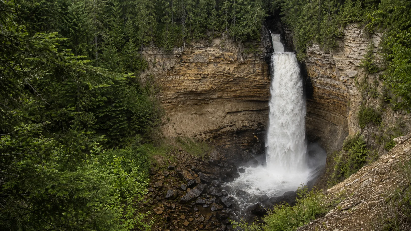
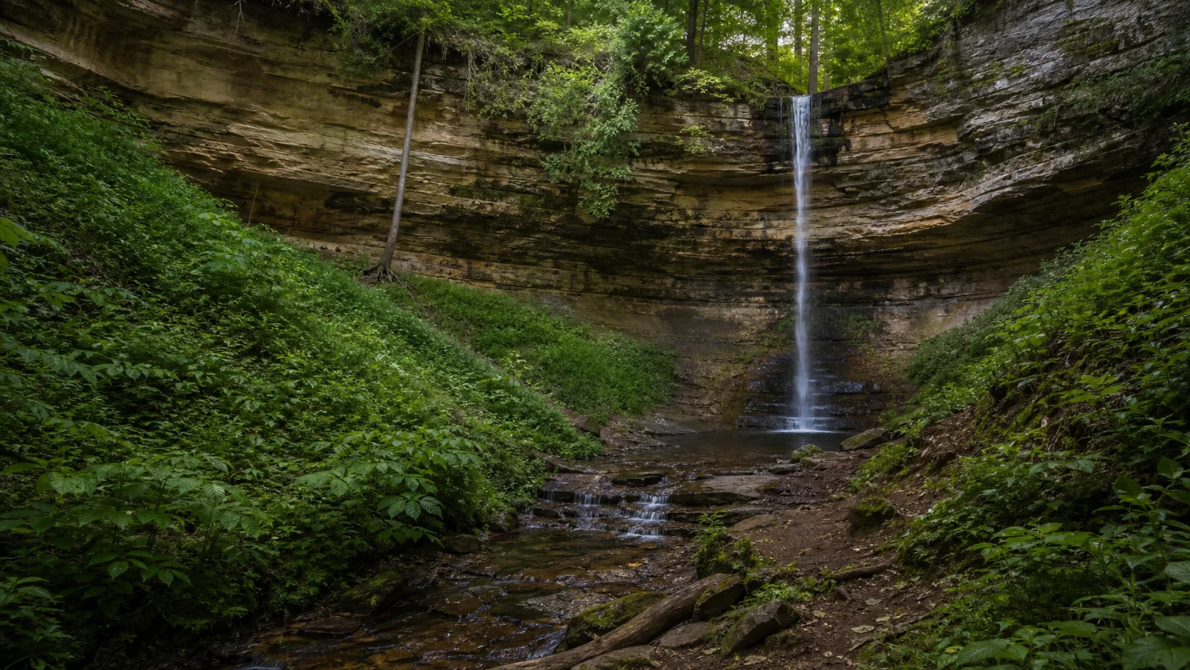
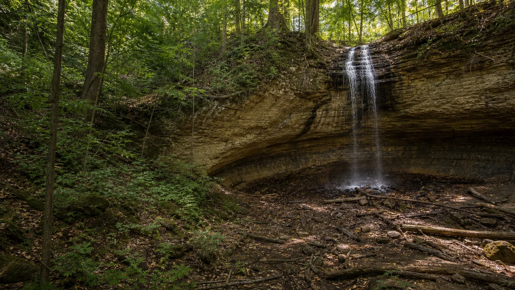
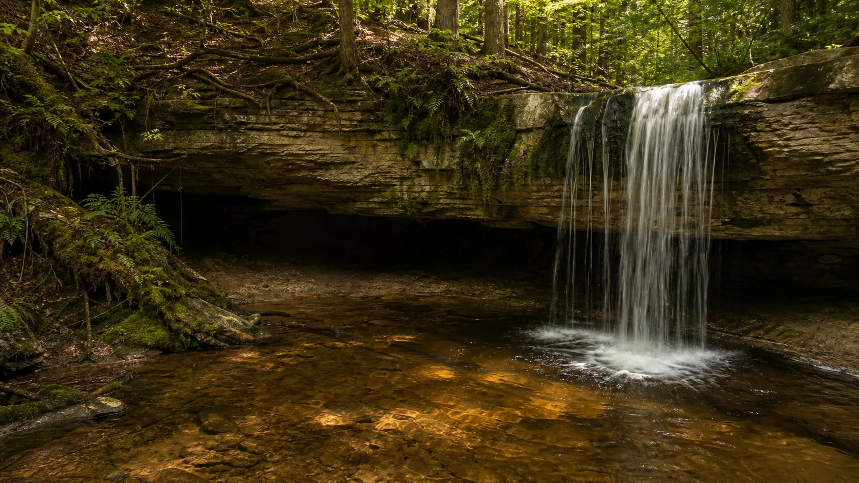
The route starts inland at Miners Falls, the loudest of the four, where Miners River drops 50 feet through a sandstone gorge inside the national lakeshore. From there it cuts back into the town of Munising for Munising Falls (a 50-foot horsetail plunge directly behind the Pictured Rocks visitor center) and Tannery Falls (a quieter cascade five minutes away on the edge of town). The route finishes 14 minutes west on M-28 at Scott Falls, a 20-foot drop visible from the highway shoulder in Au Train Township, where the same sandstone produces a sheer curtain you can walk behind.
The whole loop fits inside a single morning or afternoon. That leaves the rest of the day open for a Pictured Rocks Cruises boat tour out of Munising, a Hiawatha National Forest paddle on Au Train Lake, or a walk along the Lakeshore at Sand Point. Few waterfall routes anywhere in the country deliver four named falls plus a national-lakeshore boat tour in 12 daylight hours.
Best suited to: visitors with one day in the eastern UP, families with kids who do not want long hikes (every stop is under 1.5 miles round trip), and photographers chasing the orange-sandstone curtain look that defines Munising falls.
Start at 9 a.m. before the Miners Castle Road parking fills with cruise-tour day-trippers. Park at the signed Miners Falls trailhead off County Road H-58, three miles past the Miners Castle turnoff. The 1.2-mile out-and-back is gravel with a 77-step staircase to the lower viewpoint at the end; the upper deck is wheelchair accessible. Miners River drops 50 feet through Munising Formation sandstone here, and the volume is the highest of the four falls. Pack bug spray May through July (the deer flies are real). National Park Service entrance fee covers this stop.
Drive back south on County Road H-58 into Munising and park at the Pictured Rocks Visitor Center on Sand Point Road. The 0.2-mile paved walk and boardwalk leads behind a 50-foot horsetail dropping off an undercut sandstone shelf; you can walk into the alcove behind the curtain when flow is moderate. Spend 15 minutes inside the visitor center first for the Pictured Rocks geology exhibits, which make Miners and Scott Falls easier to read. National Park Service fee covers entry. Free public restrooms here are the best on the loop.
Three minutes from Munising Falls, on the eastern edge of town. Park at the small Tannery Falls trailhead lot off Washington Street; the trail is a 0.2-mile dirt path through hardwoods to a viewing area below the falls. This is the quietest of the four stops, the one most visitors skip, and it gives the best feel for what these UP cascades look like without a national-lakeshore boardwalk treatment. Grab a pasty or coffee in downtown Munising on the walk back to the car (multiple cafes on Cedar Street); this is the natural mid-loop fuel break.
Head west on M-28 toward Au Train. Scott Falls is 50 feet off the highway shoulder in a small Hiawatha National Forest pullout across from the Lake Superior beach. Park, walk 20 paces, and you can stand directly behind the 20-foot sandstone curtain. This is the easy finish and the family-friendly highlight of the day. After Scott, the natural extensions are: drive 5 minutes to Au Train Lake for a paddle, continue 35 minutes west to Marquette for dinner, or turn back to Munising for an evening Pictured Rocks sunset cruise.
Why this route, in this order.
The stop order moves from the longest trail to the shortest, which matters when you are pairing this with a boat tour or trying to squeeze the loop into a half day. Miners Falls is the only stop that requires a real walk (1.2 miles round trip on a maintained gravel path with a 77-step descent at the end). Doing it first, while legs are fresh and parking is still light at the Miners Castle Road trailhead, banks the only meaningful exertion of the day.
Munising Falls and Tannery Falls come next because they are inside the city of Munising itself. Both are short paved or boardwalk walks of under 10 minutes. Stacking them back-to-back lets you reuse the parking pass momentum and grab a coffee or pasty at one of the cafes on Cedar Street between visits. The Pictured Rocks Visitor Center is at the Munising Falls trailhead and is worth 15 minutes for the geology exhibits before walking out to the falls.
Scott Falls is last on purpose. It is the smallest of the four (a 20-foot drop you can almost touch from the M-28 shoulder), and finishing the loop there positions you 14 minutes west of Munising heading toward Marquette for dinner, or 14 minutes from Au Train Lake if you want to extend the day with a paddle. Doing Scott first and finishing inland would force a backtrack into Munising. The published order is a clean west-trending arc that ends pointing toward sunset over Lake Superior.
Food, fuel, and lodging.
Munising is the only meaningful service town on the route. It has a Holiday gas station on M-28, several pasty shops and cafes on Cedar Street (the pasty is the UP signature, a meat-and-potato handpie that originated with Cornish miners), a small grocery (Tony's), and the Pictured Rocks Cruises dock at the City Pier. Plan all fuel, food, and restrooms around Munising itself; Au Train is too small.
Lodging anchors
Munising has a strip of motels and small inns along M-28 and a handful of vacation rentals; book ahead June through August because Pictured Rocks demand fills rooms.
Marquette, 45 minutes west, has more lodging variety and better restaurants if you want a base for two days.
National Park Service campgrounds inside Pictured Rocks (Little Beaver Lake, Twelvemile Beach) book through recreation.gov and fill weeks ahead in summer.
Fees and permits
Pictured Rocks National Lakeshore entry fee covers Miners Falls and Munising Falls; $25 per vehicle, valid seven days, or America the Beautiful pass.
Tannery Falls is on city/township land and is free.
Scott Falls is on Hiawatha National Forest land and is free; the highway pullout has no fee station.
What to bring: bug spray (deer flies and black flies May through July), water shoes if you want to wade at Scott, layers (Lake Superior keeps the shoreline cool even in July), and cash for pasties in town. Cell service is patchy on County Road H-58 between Miners and Munising Falls but reliable in town.
Best season for this route.
Mid-June through early October is the working window. June brings the loudest flow because Lake Superior snowmelt and spring rain are still in the system; expect strong wide curtains at Munising Falls and Miners. July and August are the warmest and the busiest, with Pictured Rocks cruise demand peaking; book boat tours weeks ahead. The trail to Miners and the Munising Falls boardwalk are both fine in any summer weather, but August can bring sustained warm humidity that brings out the deer flies.
Late September into early October is the quieter alternative and the photography peak. The maple and birch hardwoods around Tannery Falls and along County Road H-58 turn orange and gold; combined with the orange Munising sandstone the look is uniquely UP. Crowds drop sharply after Labor Day. Watch the forecast because the first Lake Superior storms can arrive in early October.
Winter is a different route entirely. Munising Falls freezes into a column that ice climbers use, and the National Park Service maintains a winter access trail. Miners and Tannery Falls are reachable by snowshoe but the County Road H-58 maintenance is intermittent. Scott Falls is reachable directly from M-28 year-round. The full four-stop loop as written assumes summer or fall driving and the closure of the Pictured Rocks scenic roads is the limiting factor December through April.
Questions about this route.
Can I do all four falls and a Pictured Rocks boat tour in one day?
Yes, comfortably. The waterfall loop takes about three hours including stops, drive time, and a coffee in Munising. Pictured Rocks Cruises runs roughly 2.5-hour boat tours of the painted sandstone cliffs out of the Munising City Pier multiple times daily June through October. Do the waterfall loop 9 a.m. to noon, eat lunch in Munising, then take a 2 p.m. or 4 p.m. cruise. Book the boat tour ahead in July and August because afternoon sailings sell out days in advance.
Do I need a Pictured Rocks entry fee?
Yes, for two of the four stops. Miners Falls and Munising Falls are both inside Pictured Rocks National Lakeshore and require a $25 per vehicle entrance fee valid seven days, or an America the Beautiful annual pass. Tannery Falls is on township land and is free. Scott Falls is on Hiawatha National Forest land at a free highway pullout. The National Park Service fee booth on Sand Point Road in Munising sells day passes and is the easiest place to pay before walking to Munising Falls.
Are these falls accessible without long hikes?
Yes. Munising Falls and Scott Falls are essentially roadside, both under five minutes from the parking lot. Tannery Falls is a 0.2-mile dirt walk. Miners Falls is the longest at 1.2 miles round trip on a gravel path with a 77-step staircase to the lower viewpoint; the upper viewing deck is wheelchair accessible. Total walking across all four stops is under three miles. This route is realistic for families with young kids and for visitors who do not want a strenuous hike day.
Where should I stay overnight?
Munising itself is the obvious base. The town has a strip of motels and small inns along M-28 plus a handful of vacation rentals; book ahead June through August. Marquette, 45 minutes west, has more lodging variety and a livelier dining scene if you want a two-night base. Pictured Rocks National Lakeshore has campgrounds (Little Beaver Lake, Twelvemile Beach) that book through recreation.gov months ahead for summer dates. For a quieter alternative, Au Train Township has small lakeside cabins five minutes from Scott Falls.
Is the route doable in winter?
Partly, not as written. Munising Falls freezes into a famous ice column used by climbers, and the National Park Service keeps a winter access trail open for ice viewing. Scott Falls is directly off M-28 and reachable year-round. Miners Falls and Tannery Falls become snowshoe destinations because County Road H-58 maintenance drops off in winter. The summer four-stop loop in one driving day is not realistic December through April. For a winter ice-falls visit, plan a Munising Falls plus Eben Ice Caves day instead.
What's the best photography stop on this route?
Munising Falls for first-time visitors, because you can stand inside the alcove behind the curtain and shoot the falls against the orange Munising Formation sandstone. Miners is the most powerful in volume and looks best at midday when light hits the gorge. Scott Falls is the cleanest sandstone curtain and is best in early morning sidelight from the Lake Superior side. In fall, Tannery Falls becomes the surprise winner because the surrounding hardwoods turn deep orange and frame the cascade unusually well.
Are dogs allowed at these falls?
Mixed. Inside Pictured Rocks National Lakeshore, dogs are allowed on leash on most maintained trails including the path to Miners Falls and the Munising Falls boardwalk; check the current National Park Service pet policy because closures rotate. Tannery Falls and Scott Falls are both leash-friendly. Pictured Rocks Cruises does not allow pets on boat tours, so plan the boat portion separately if you bring a dog. Always pack out waste; the Munising Formation sandstone is fragile and bag-burying is prohibited.