Columbia Gorge to North Umpqua: a four-stop Oregon waterfall weekend.
Four falls, two days, and roughly seven hours of driving from Latourell in the Columbia Gorge across Mt Hood to White River and down to the North Umpqua corridor at Watson and Toketee.
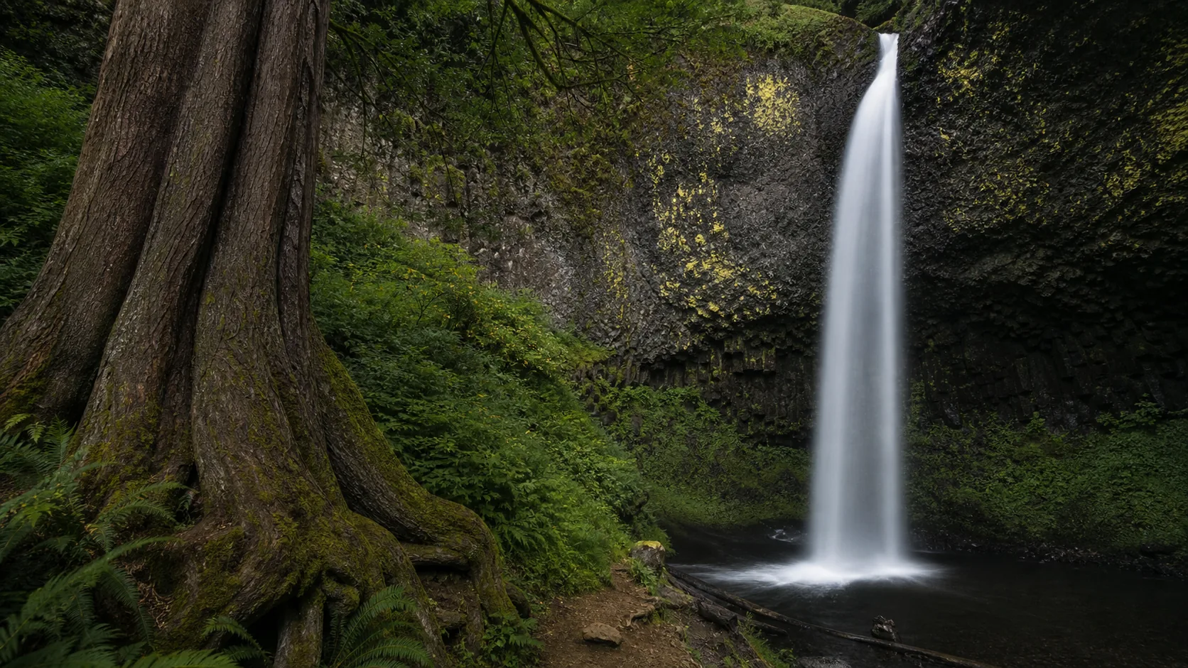
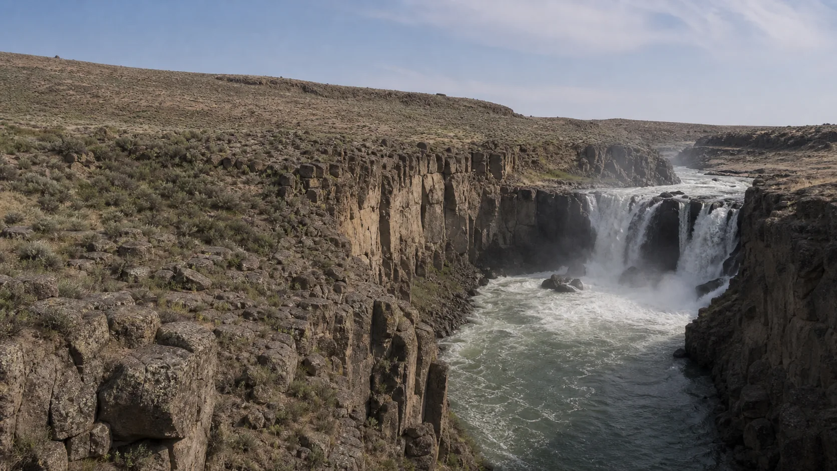
This is the classic Oregon waterfall weekend in four moves. It starts on the Historic Columbia River Highway 30 minutes east of Portland, where 249-foot Latourell Falls drops in a single plume against an undercut wall of columnar Grande Ronde basalt streaked with chartreuse-yellow lichen. From there the route climbs US-26 over the south flank of Mt Hood, drops onto OR-216 through the high desert above Tygh Valley, and finishes Day 1 at White River Falls, a 90-foot Columbia River Basalt plunge fed by Mt Hood glacial meltwater with the masonry shell of a 1910 hydroelectric plant still standing at the base.
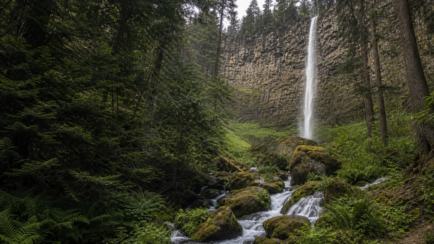
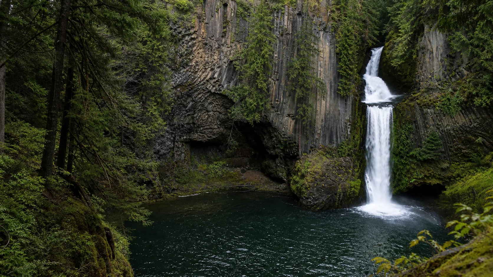
Day 2 is the long Oregon drive south. The route follows US-97 past the east side of the Cascades, slips west on a connector to I-5 at Eugene or Roseburg, then turns east on OR-138, the Rogue-Umpqua Scenic Byway. Within four miles of each other on the upper North Umpqua sit Watson Falls (272 feet of plunge into a mossy basalt bowl, the third-tallest single-drop waterfall in Oregon) and Toketee Falls (two tiers into a tight columnar basalt amphitheater that has become one of the most photographed scenes in the Pacific Northwest). Total weekend driving is roughly six to seven hours, split unevenly: light on Day 1, heavy on Day 2.
The route works because it crosses three of Oregon's distinct waterfall geologies in 48 hours. Latourell drops over 17-million-year-old Columbia River Basalt Group flows that draped the Gorge. White River drops over a younger basalt rim on the dry east side of the Cascades. Watson and Toketee both spill off High Cascades volcanic flows fed by the deep aquifer beneath the North Umpqua, which keeps base flow strong even in late summer. You see the same rock family rendered three different ways by climate, water source, and forest type.
Best suited to: drivers who want a real Oregon waterfall weekend rather than a single-day Gorge tour, photographers willing to trade some miles for big single-drop falls, and anyone wanting to combine a Mt Hood crossing with a Crater Lake adjacent finish (Toketee is 90 minutes from Crater Lake's north entrance).
Start here at 9 a.m. before the Historic Columbia River Highway pullouts fill. Park in the small Guy W. Talbot State Park lot off the Historic Columbia River Highway; arrive early on summer weekends because the lot turns over slowly. Walk the 0.2-mile paved path to the lower viewpoint for the columnar basalt and lichen wall, then loop the 2.4-mile upper trail if you have time. Pack light snacks and a coffee from Troutdale or Corbett on the drive in. Aim to be back at the car by 10:30 to hit US-26 before Mt Hood traffic builds.
110 min · 90 mi from previous stop1 hr 15 min on site
Drive US-26 east over Mt Hood and turn south on OR-35, then OR-216 through Tygh Valley. The state park gate is open mid-April through mid-October only; the route does not work in winter. Park at the rim viewpoint, take photos of the 90-foot basalt plunge, then walk the steep quarter-mile descent past the 1910 powerhouse ruins to the base. The masonry shell of the hydroelectric plant is the unexpected story here, not the falls themselves. Pack water; the canyon bakes in summer afternoons. Eat a tailgate lunch at the picnic tables before the long Day 2 drive.
270 min · 215 mi from previous stop~45 min on site
This is the long Day 2 drive: US-97 south to a connector across to I-5, then OR-138 east up the North Umpqua. Time it so you arrive at Watson with at least 90 minutes of daylight left, because Toketee is next and the stair descent benefits from light. Park at the marked Watson Falls Trailhead (Northwest Forest Pass required, or $5 day pass at the box). The 0.6-mile out-and-back climbs through old-growth Douglas-fir to a footbridge directly under the 272-foot plunge. Cool, mossy, and loud in late spring; pack a rain shell for the spray.
Five minutes west on OR-138, then north on Forest Road 34 to the Toketee trailhead. Northwest Forest Pass covers this lot as well. The 0.4-mile path descends roughly 200 cedar steps to a wooden viewing deck above the columnar basalt amphitheater. This is the postcard frame of Oregon waterfalls. Time the visit for the last hour of daylight; the deck faces northwest and catches good evening sidelight against the columns. Do not attempt the unofficial scramble down to the pool; people have died here. Camp at Toketee Lake CG or push 30 minutes back to Diamond Lake or Idleyld Park for lodging.
Why this route, in this order.
The stop order is built around one constraint and one payoff. The constraint is Mt Hood. US-26 over the pass is the only practical road link between Portland and the dry east-side basalt country where White River sits, and it is best driven in daylight. Starting at Latourell at 9 a.m. puts you on US-26 by late morning and over the pass before afternoon weather builds in winter, or before the heat radiates off the basalt in summer.
The payoff is the contrast between Day 1 and Day 2. Day 1 is short, scenic, and ends in the high desert with a falls almost no one outside Oregon has heard of. Day 2 is a long highway day rewarded by two of the tallest single-drop falls in the state sitting within five minutes of each other. Doing Watson and Toketee on the same afternoon is mandatory; both are on the same access road off OR-138 and skipping either after driving 4.5 hours to get there would be perverse.
Other orders feel worse. A Gorge first plus Umpqua first plus White River last makes Day 2 a 5-plus-hour drive back north through traffic. Doing Watson and Toketee on Day 1 and finishing at Latourell on Day 2 puts the long drive at the start and pushes the iconic Gorge view into a tired evening light. The published order keeps the morning energy on the Gorge, uses the Mt Hood crossing as the midday scenic transition, and saves the loud roar of Watson for late on Day 2 when the canyon is in shade and the spray catches sidelight.
Food, fuel, and lodging.
Day 1 is light on services. Fuel and coffee in Troutdale or Corbett before the Gorge, then a real lunch stop in Government Camp on US-26 (the village has a handful of mountain restaurants and a small grocery). Tygh Valley itself is tiny; gas in Maupin on OR-197 or back at Government Camp.
Day 2 is the supply day. Fill up in Madras or Bend on US-97, eat lunch in Roseburg or at the Steamboat Inn on OR-138 (the inn's dining room is a regional anchor and worth the stop if open), and stock water and snacks before turning east on OR-138. The North Umpqua corridor has no real services between Glide and Diamond Lake.
Lodging anchors
Night before Day 1: Portland, Troutdale, or Cascade Locks for an early Gorge start.
Night between Day 1 and Day 2: Government Camp, Hood River, or Tygh Valley area; Hood River gives the best dinner options and adds 20 minutes to Day 2.
Night of Day 2: Idleyld Park, Diamond Lake, or push west to Roseburg. The Steamboat Inn area has rustic cabins along the North Umpqua.
Fees and permits
Latourell: free (Oregon State Parks).
White River Falls: free, gate open mid-April through mid-October only.
Watson and Toketee: $5 day-use parking or Northwest Forest Pass (annual, $30).
What to bring: rain shell for Watson spray, sturdy shoes for the Toketee stairs and the White River descent, headlamp if finishing Toketee at dusk, full water bottles for Day 2 (the OR-138 corridor has no convenience stores).
Best season for this route.
The hard constraint is White River Falls State Park, which closes its gate from mid-October through late April. That single closure rules out the route November through April. Within the open window, two sub-seasons work best.
Late May through early July is peak. Mt Hood snowmelt feeds White River at its loudest, the North Umpqua is still pushing hard on Cascade snowmelt through the aquifer, and Latourell stays full from spring rain. June is the all-around best month: long daylight, full flow, and the OR-138 corridor is past mud season but before high-summer fire smoke. Wildflowers along the Watson trail peak the first two weeks of June.
September into early October is the quieter alternative. Crowds thin sharply after Labor Day, Toketee flow stays respectable because the volcanic aquifer keeps base flow up even in late summer, and the Gorge gets clear, cool mornings. The trade-off is dimmer light at White River and a risk of early-season wildfire smoke through mid-September.
Avoid: August heat in the Tygh Valley canyon (90-plus F is common at White River and there is no shade on the descent), and July weekends when Latourell parking fills before 9 a.m. Winter is not an option for this route because of the White River gate closure plus Mt Hood pass conditions on US-26.
Questions about this route.
Can I do this route in one day?
No, not honestly. The total driving is roughly six to seven hours across the four stops, and the Watson to Toketee evening alone needs daylight. The route is designed as a two-day weekend with an overnight near Mt Hood, Hood River, or Tygh Valley between Day 1 and Day 2. Trying to compress it into one day means skipping either the Gorge or the Umpqua corridor, which defeats the point. If you only have one day, do Latourell plus White River as a day loop from Portland, or Watson plus Toketee as a day loop from Roseburg, but not all four.
Where should I stay overnight between Day 1 and Day 2?
Three viable anchors. Government Camp on US-26 puts you right at the Mt Hood crossing with mountain-village dining; it is the most efficient for the next-day push south. Hood River 25 minutes north of US-26 has the best dinner and brewpub options and an easy morning drive back to US-26; it adds about 20 minutes to Day 2. The Tygh Valley and Maupin area on the dry side of Mt Hood is the closest to White River Falls itself but has limited dining. Pick based on whether you prioritize next-day driving efficiency (Government Camp) or evening atmosphere (Hood River).
Are any of these falls closed in winter?
White River Falls State Park closes its gate from mid-October through late April every year. That makes the four-stop route effectively a May to early October trip. Latourell stays open year-round but the Historic Columbia River Highway can close briefly during ice storms. Watson and Toketee technically stay open year-round, but OR-138 east of Roseburg sees snow and ice from late November through March and the Toketee stair descent is dangerous in icy conditions. The honest window for the full four-stop weekend is mid-May through mid-October.
Is the road to Watson and Toketee paved?
Yes for both. OR-138 (the Rogue-Umpqua Scenic Byway) is paved all the way past both trailheads. The Toketee Falls access spur is a short paved Forest Road 34 turnoff, also passenger-car friendly. There are no gravel sections on the route between Latourell and Toketee. The only rough surface is the descent trail at White River Falls, which is a steep dirt path past the powerhouse ruins, not a road.
Do I need a permit for any of these stops?
Two of the four require parking fees. Watson Falls and Toketee Falls both sit on Umpqua National Forest land and require a $5 per-vehicle day pass (sold at the trailhead self-pay station) or a Northwest Forest Pass (annual, $30, sold at REI and Forest Service offices). Latourell Falls is free; Guy W. Talbot State Park charges no day-use fee. White River Falls State Park is also free. No timed-entry permits apply on this route; the Multnomah Falls summer timed-entry pilot is not relevant because the route uses Latourell, not Multnomah.
What's the best photography stop on this route?
Toketee, by a wide margin. The two-tier plunge into the columnar basalt amphitheater is one of the most recognizable scenes in the Pacific Northwest, and the wooden viewing deck gives a clean frame. Late afternoon sidelight (roughly 4 to 7 p.m. in summer) is best because the deck faces northwest. Second place is Latourell at sunrise, when the chartreuse lichen on the basalt wall catches first light. White River is the dark horse: the 1910 hydroelectric ruins below the falls give an unusual industrial-archaeology composition that almost no Oregon waterfall offers.
Can I add Multnomah Falls to this route?
Yes, easily, on Day 1. Multnomah is 10 minutes east of Latourell on the Historic Columbia River Highway and adds maybe 45 minutes to the morning if you walk to the Benson Bridge viewpoint. Note that Multnomah requires a timed-entry permit between Memorial Day and Labor Day under the current Forest Service pilot; book in advance through recreation.gov. The route also works well as a five-stop variant adding Wahkeena or Horsetail without significantly changing the Day 1 timing.