Hemmed-In-Hollow Falls 209-foot single-drop plunge over Ozark sandstone bluff in the Ponca Wilderness of Buffalo National River
Compton, AR

Hemmed-In-Hollow Falls

Hemmed-In-Hollow Falls is a 209-foot wet-weather plunge in the Ponca Wilderness of Buffalo National River, widely cited as the tallest waterfall between the Rockies and the Appalachians. It drops from the rim of an Ozark sandstone bluff into a horseshoe amphitheater enclosed on three sides by 300-foot cliffs. The flow is highly seasonal: a thundering free-fall in February through May, a thin trickle or bone-dry stain on the rock by August.

Last verified May 12, 2026 Visited Desk-verified May 2026 8 sources checked
Trail 5.5 mi 11.0 mi extended
Time 180-360 min Hard
Best season Feb-May for guaranteed flow; October for color Feb-May after rain
Parking All three trailheads are free; Compton lot fills first on spring weekends, arrive by 9am Buffalo National River (Ponca Wilderness)
Quick answer

Is Hemmed-In-Hollow Falls worth the hike?

Yes if you go between mid-February and mid-May (within 48 hours of measurable rain is the safest bet) or during peak fall color in mid to late October. The standard 5.5-mile loop from the Compton Trailhead is the most popular route and is free, with no permits or NPS entry fees required. Skip the trip in summer dry spells: by August the falls often runs dry, and the steep 1,400-foot climb back out is brutal without a payoff at the bottom.

  • Wet-weather: visit Feb-May or 48 hr after rain
  • 5.5 mi loop from Compton (most common)
  • Free, no NPS fee, no permit
  • 1,400 ft climb back out
  • Tallest between Rockies and Appalachians
  • October for fall color
Last verified May 12, 2026 Visited Desk-verified May 2026 8 sources checked
Distance 5.5 mi 11.0 mi extended
Round trip 180-360 min Roughly 1,400 ft elevation gain on the return; the climb back out is the crux of every route
Difficulty Hard Roughly 1,400 ft elevation gain on the return; the climb back out is the crux of every route
Location Compton, AR Buffalo National River (Ponca Wilderness)
Parking All three trailheads are free; Compton lot fills first on spring weekends, arrive by 9am NPS
Transit No fixed-route transit; private vehicle required Compton Trailhead (gravel lot off Newton County Road 19, signed for Hemmed-In Hollow) · 0 ft
Drive 17 mi 30 min from downtown
Best season Feb-May for guaranteed flow; October for color Feb-May after rain
Hemmed-In-Hollow Falls from the amphitheater floor looking up at the lip 209 feet above
Photo guide

What 209 feet of free-falling water looks like from below.

The signature frame is taken from the amphitheater floor looking straight up at the bluff. The cliff scale is hard to read without a person for context, so put a hiker in the frame and shoot at 16-24mm equivalent.

Hemmed-In-Hollow Falls 209-foot single-drop plunge over Ozark sandstone bluff in the Ponca Wilderness of Buffalo National River
Hemmed-In-Hollow Falls, hero composition
Hemmed-In-Hollow Falls 209-foot single-drop plunge against Ozark sandstone bluff amphitheater
Wide view of the 209-foot free-fall and curving sandstone amphitheater
Hemmed-In-Hollow Falls viewed from the amphitheater floor with the lip 209 feet overhead
From the amphitheater floor looking up at the lip 209 feet above
Hemmed-In-Hollow Falls water hitting the talus with wet Atoka sandstone bluff face behind
Water-and-rock detail showing the Atoka sandstone bluff face
01Is Hemmed-In-Hollow Falls flowing right now?

Live data on the right uses USGS gauge 07055646 (Buffalo River near Ponca) ↗ as a proxy. The gauge is on the Buffalo River about 7 km from the falls, so it tells you whether the surrounding watershed is wet, not the exact flow over the lip. Above 200 cfs on the Ponca gauge the falls usually runs well; below 50 cfs it is likely a trickle or dry.

02How long is the walk?

The standard route from the Compton Trailhead is 5.5 miles loop (or 5.7 miles out-and-back), with about 1,400 feet of elevation loss on the way in and the same gain coming out. The Centerpoint upper-rim option is 4 miles round trip with no descent. The Indian Creek / Kyles Landing river-side approach is 10-11 miles round trip on gentler grades; better in hot weather, longer overall.

03How do you get there?

From Compton, Arkansas (on AR-43): drive 1 mile east on Newton County Road 19 to the signed Compton Trailhead gravel lot. From Jasper, drive 15 miles north on AR-7 then AR-43 to Compton. From Northwest Arkansas Regional Airport (XNA), allow 2.5 hours via US-65 south and AR-43 east.

04Is there free parking?

All trailheads are free with no NPS entry fee. Compton's gravel lot holds about 25 cars and fills before 9am on spring weekends; arrive early or use Centerpoint as overflow. No restrooms at the trailheads.

05Does it cost money?

Free. Buffalo National River has no entrance fee. No permit is required for day hiking. Backcountry camping requires a free permit; commercial photography and weddings require an NPS Special Use Permit ($50+).

06Trail variants

Compton Trailhead (most common) 5.5 mi loop or 5.7 mi out-and-back, 3-4 hr, shortest standard route; steep 1,400 ft climb on the return.
Centerpoint Trailhead 4 mi out-and-back to the upper bluff overlook, 2-3 hr, shortest mileage but no descent into the hollow; the falls is viewed from above.
Indian Creek / Kyles Landing approach 10-11 mi out-and-back, 5-6 hr, longest but gentler grades; better choice for hot weather.
River float from Ponca or Steel Creek varies, plus a 0.6 mi walk in from the river, half-day to full day, an alternative March-May approach when the Buffalo River is floatable.

Detailed maps and recent reviews: Falls route on AllTrails · Creek route on AllTrails

07Can you swim?

The shallow plunge pool at the base of the falls is more puddle than pool in low water; wading is tolerated but the surface is slick limestone and uneven. For real swimming, head to the Buffalo River at Steel Creek (6 mi) or Kyles Landing (4 mi).

08Are dogs allowed?

Yes, on a leash no longer than 6 feet. The trail is steep, rocky, and unshaded in places; not a good choice for small or unconditioned dogs, especially in summer heat.

09Is it accessible?

Not accessible. All three approaches require multiple miles of unimproved trail with significant grade. The Centerpoint upper-rim view is the closest to a step-free option but still involves uneven dirt path and stone.

Field notes

Hemmed-In-Hollow at a glance.

209-foot single-drop plunge over Atoka and Bloyd sandstone, inside the 11,300-acre Ponca Wilderness of Buffalo National River, managed by the National Park Service, free to enter. Sourced from the NPS park page and the Arkansas Geological Survey.

Height 209 ft USGS 3DEP
Type Plunge (single drop, wet-weather) USGS
Rock Atoka and Bloyd sandstone (Boston Mountains, Ozark Plateau) Arkansas Geological Survey: Boston Mountains and Atoka/Bloyd sandstones
County Newton Compton, AR
Managed by U.S. National Park Service NPS
Water source Unnamed seasonal Ozark stream draining into Sneeds Creek and the Buffalo River USGS
Elevation 1430 ft USGS NED
Park area 95,730 acres NPS
Hours Trailheads open 24 hours; the back-country falls itself is day-use only and has no fixed hours NPS
When to visit

Two windows that justify the drive; the other ten months are a gamble.

February through May after rain for the full free-fall. Mid to late October for fall color on the bluff. The rest of the year, check the Ponca gauge before driving: above 200 cfs the falls is probably running, below 50 cfs it is probably dry.

PEAK FLOW

Peak flowFeb-May after rain
Ice / low flowBrief ice in cold snaps
Most crowdedWeekends and midday
Best photosSunrise or weekdays

Live water context

Discharge data -- Live reading from Buffalo River near Ponca (proxy gauge, 7 km from falls) (USGS 07055646) refreshes on the next build. Open the gauge link below for the current cubic-feet-per-second reading.

USGS 07055646 · Buffalo River near Ponca (proxy gauge, 7 km from falls)

Why is it called Hemmed-In-Hollow Falls?

The name is descriptive English, not Indigenous. The hollow itself is hemmed in by 300-foot sandstone bluffs that form a horseshoe-shaped amphitheater on three sides, leaving only the narrow Sneeds Creek drainage as a way in or out. Early Ozark settlers used the word hollow for the deep, sheltered valleys between bluff lines, and the name simply records what the landform does to anyone standing at the base of the falls.

What else to do at Buffalo National River (Ponca Wilderness)

Buffalo National River was the first river in the United States designated a national river, signed into law in 1972 by President Nixon to protect 135 miles of free-flowing Ozark river from a series of proposed dams. The Ponca Wilderness, which holds Hemmed-In Hollow, is the western section of the park; Ponca (gas, paddle outfitters, a few cabins) and Jasper (the Newton County seat, 15 miles south) are the practical base towns. The three Hemmed-In Hollow approaches start at Compton (5.5 mi loop), Centerpoint (4 mi upper-rim view), and Kyles Landing or Indian Creek on the river side.

  • Ponca Wilderness. 11,300 acres of federally designated wilderness inside Buffalo National River; no roads, no motorized use, and Hemmed-In Hollow sits roughly in the center.
  • Compton Trailhead. Gravel lot off Newton County Road 19, the most common starting point and the shortest standard route. Fills before 9am on spring weekends.
  • Centerpoint Trailhead. Upper-rim approach that ends at a top-of-bluff overlook; no descent, no payoff at the base, but a way to see the amphitheater from above when river levels are too low to reach the floor comfortably.
  • Sneeds Creek crossing. The last quarter mile of the standard route follows Sneeds Creek into the hollow; expect ankle-deep water in spring and a dry rock bed in summer.
  • Buffalo River float access. March to May the river is floatable, and a half-mile walk from the river up Sneeds Creek is the easiest approach when you can paddle in.

Why it looks this way

The bluffs are Atoka and Bloyd sandstones, Pennsylvanian-age layers that form the rim and upper walls of most Boston Mountains canyons. These are hard, well-cemented sandstones over softer shale layers, the same caprock-over-softer-rock combination that produces nearly every major Ozark waterfall.

The Hemmed-In Hollow itself is not a stream-cut canyon. It is a recess amphitheater, formed where groundwater seeping through the sandstone weakened the cliff face and large slabs sheared off along vertical joints, retreating into the bluff over geologic time. The waterfall is a small intermittent stream tipping over the rim of that amphitheater. Because the drainage above the lip is tiny (roughly half a square mile) and the sandstone above is permeable, water reaches the rim only after rainfall fills the shallow soils on top. Once the soil dries out, the falls turns off.

Field guide deep dive

What the brochures leave out about a 209-foot wet-weather falls.

Why the falls is often dry, what makes the "tallest in mid-continent" claim hold up, which trailhead is actually easiest, and how the Ponca river gauge tells you whether to drive at all.

How Hemmed-In Hollow formed

The Boston Mountains, the high plateau that forms the southern half of the Ozarks, are layered Pennsylvanian-age sandstones (Atoka and Bloyd formations) sitting over softer Mississippian shales and limestones. The Buffalo River cut through this stack over millions of years, exposing the sandstone as bluff lines along the canyon walls. Hemmed-In Hollow is not a stream-cut canyon. It is a recess amphitheater, a horseshoe-shaped scoop in the sandstone bluff where the cliff face has retreated into itself rather than being cut by water from the outside.

The mechanism is groundwater seepage and freeze-thaw spalling. Water moves slowly through the permeable sandstone above and emerges at the cliff face, weakening the rock along vertical joints. In winter, water inside those joints freezes and expands, and over geologic time large slabs of bluff shear off and fall to the talus pile below. The amphitheater grows by retreat, not by undercut. The waterfall itself is a small intermittent stream tipping over the rim of that amphitheater; it does not carve the hollow, it just decorates it.

The drainage above the lip is tiny: roughly half a square mile of shallow soil on top of permeable sandstone. That small catchment, combined with the porous bedrock, is exactly why the falls is wet-weather only. The soil up top can hold a couple of days of rain, no more.

The "tallest between the Rockies and the Appalachians" claim

The National Park Service lists Hemmed-In Hollow at 209 feet, with some sources rounding to 210. That makes it the tallest waterfall in Arkansas and, according to NPS and the regional tourism literature, the tallest single-drop waterfall in the continental United States between the Rocky Mountains and the Appalachian Mountains, a span of roughly 1,500 miles of mid-continent.

The claim holds up under scrutiny with one important caveat: it is a height claim about a single-drop waterfall, not a cumulative-cascade claim. Many Ozark and Boston Mountain falls are taller if you measure end-to-end cascades or staircase falls, and several Midwestern falls (Munising's curtain falls in Michigan, the cascades of the Niagara Escarpment) are visually larger because they carry far more water year-round. What Hemmed-In Hollow has is the longest single uninterrupted plunge in mid-continent. The water hits nothing between the lip and the talus 209 feet below.

That single-drop geometry is what the "tallest" phrasing protects, and it is what makes the falls visually distinctive: a thin white thread against a curving, 300-foot sandstone wall, in scale completely unlike any other mid-continent waterfall.

Wet-weather flow: why the falls is often dry

This is the single most under-reported fact in the SERP. Hemmed-In Hollow is a wet-weather waterfall. The drainage above the lip is small, the sandstone is permeable, and once the topsoil dries out, the falls turns off. June through September it is often a trickle or a stain on the rock. By August in a dry year it can be completely dry.

The reliable rule is to visit within 48 hours of measurable rain in the immediate watershed, and to favor the February through May window when soils are saturated from winter rain and the falls runs more consistently. October sometimes works after the first fall rains, especially in cold years when evapotranspiration drops. November through January can produce icicle columns on the bluff face during cold snaps, which is its own kind of spectacular but a different reason to visit.

This site uses the USGS Buffalo River near Ponca gauge (07055646) ↗, about 7 km downstream, as a proxy. The gauge does not measure flow at the falls; it measures whether the surrounding watershed is wet. Above 200 cfs on the Ponca gauge usually means the falls is running well. Below 50 cfs the falls is likely a trickle or dry. Recent trip reports from forums and AllTrails older than a week are not reliable; the falls can go from full flow to a stain on the rock in 5 dry days in summer.

Three trailheads: which one is actually easiest

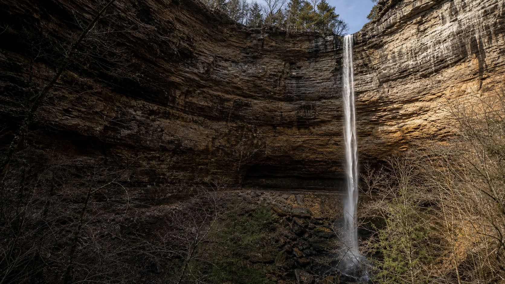
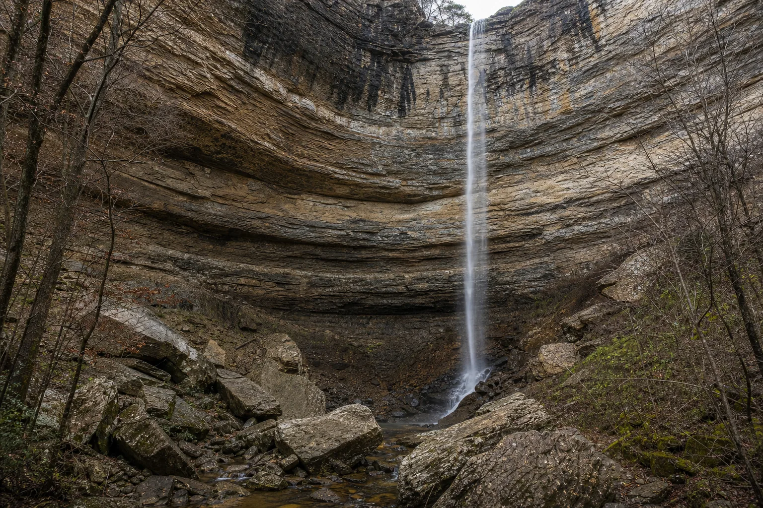
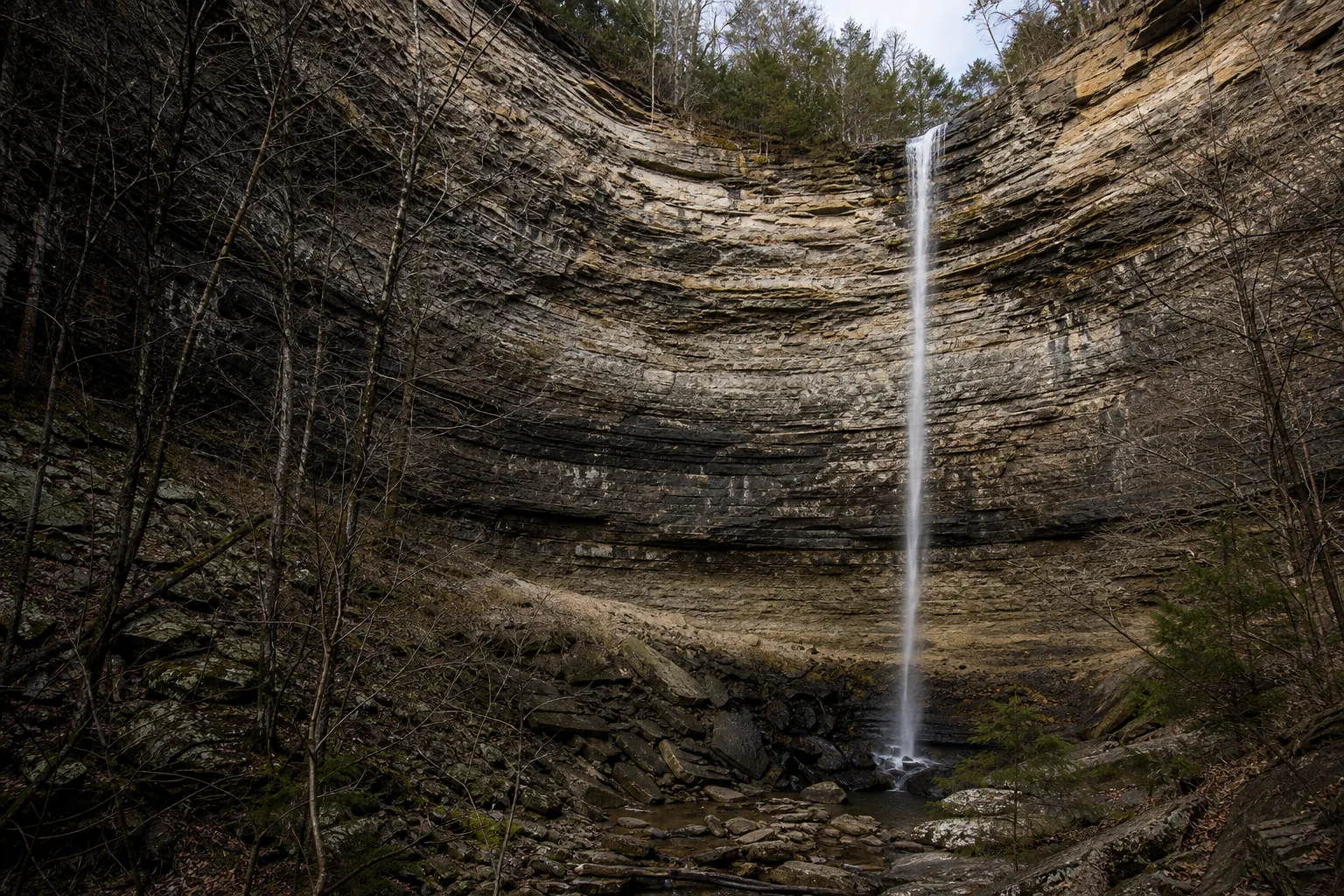
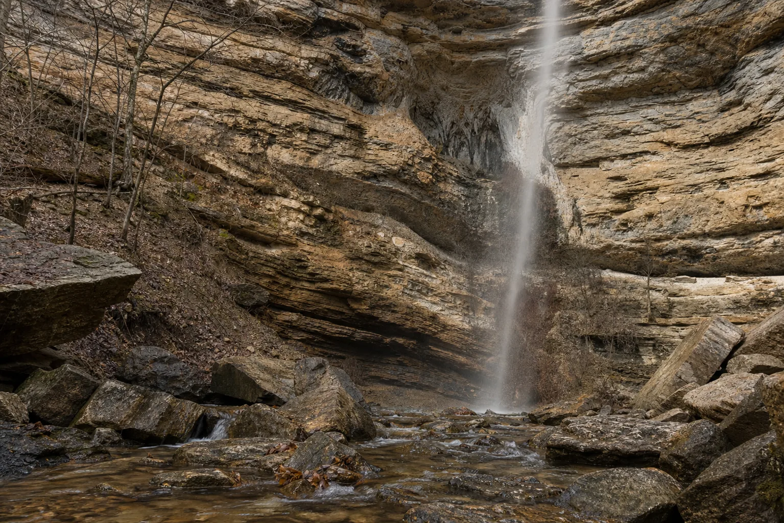
Compton Trailhead is the most common route and the one almost every trip report describes. The standard 5.5-mile loop drops about 1,400 feet from the rim down to the amphitheater floor along the Sneeds Creek drainage and climbs the same elevation back out. The descent is moderate; the return climb is the crux of the trip and the reason AllTrails rates the route "hard." The loop is signed and well-defined. Standard time is 3 to 4 hours.

Centerpoint Trailhead is shorter on the map (about 4 miles round trip) but does not descend into the hollow. It ends at a top-of-bluff overlook that gives you the amphitheater from above. The mileage is easier on legs, but the experience is fundamentally different: you do not stand at the base of a 209-foot waterfall, you look down at it. Use Centerpoint if river levels are too low for a worthwhile bottom approach, or if the Compton lot is full.

Indian Creek / Kyles Landing is the river-side approach, 10 to 11 miles round trip. The total elevation change is roughly the same as Compton, but it is distributed over more miles, so the grades are gentler. This is the route to choose in hot weather: more shade along the river bottom, fewer steep sections, and a Buffalo River swim at the end. The downside is mileage and the need to ford Indian Creek, which can be impassable in high water.

One alternative worth mentioning: in March through May the Buffalo River is floatable, and a half-mile walk in from the river up Sneeds Creek is by far the easiest approach if you can paddle in from Ponca or Steel Creek. Local outfitters in Ponca rent kayaks and canoes and can drop you at the right river access.

Buffalo National River context

Buffalo National River was signed into law by President Nixon on March 1, 1972, as the first national river in the United States. The designation came after a 20-year fight over a series of proposed Army Corps of Engineers dams on the Buffalo, which would have flooded the canyon and most of the bluff country including Hemmed-In Hollow. The successful dam-opposition campaign, led in part by the Ozark Society and Justice William O. Douglas, produced the new national-river category and made the Buffalo a model for protecting free-flowing rivers without converting them to traditional national parks.

The park covers about 95,730 acres along 135 miles of river, with three federally designated wilderness areas inside it: Ponca, Lower Buffalo, and Upper Buffalo. The Ponca Wilderness is the western section and the one that holds Hemmed-In Hollow. Ponca (population about 50) is the practical base for paddle outfitters and a handful of cabins; Jasper, the Newton County seat 15 miles south, has restaurants, gas, and lodging. Both work for a one-night or two-night trip; Ponca is closer to the trailheads.

The other classic Ponca Wilderness stop is Lost Valley, a 2.3-mile out-and-back through a side canyon with three smaller falls (Eden Falls and the Natural Bridge among them). It is the easy companion hike to Hemmed-In Hollow and works well as a second-day option when your legs are tired from the climb.

Photography practical: south-facing amphitheater, wide lens, person for scale

The amphitheater faces roughly south-southwest, which is unusual and important for photography. In the morning the bluff sits in open shade with the sky behind the rim; this is the cleanest light for the white water against dark wet sandstone. By midday the rim catches direct sun while the floor stays shaded, which produces a difficult-to-balance contrast. In the last two hours before sunset the upper bluff is lit and the spray gets backlit through the trees on the rim, which is the most atmospheric frame of the day but requires careful exposure.

The single hardest photographic problem at Hemmed-In Hollow is conveying scale. A 209-foot waterfall photographed alone reads as a thin streak on a rock face, indistinguishable from a 50-foot falls. Always put a hiker in the frame, ideally at the base of the bluff, even if you have to wait for someone to walk into the shot. The bluff curves around the photographer, so a wide-angle lens (16-24mm equivalent on full frame, or the 0.5x ultrawide on a recent phone) is necessary; standard 24-50mm will not capture the amphitheater wrap.

NPS bans drones park-wide, so the aerial perspective you might want from above is not available. The Centerpoint upper-rim trail gives you a substitute (looking down into the amphitheater) and is the only way to legally photograph the falls from above.

Map and route

Three trailheads, one back-country waterfall.

From Compton, Arkansas (on AR-43): drive 1 mile east on Newton County Road 19 to the signed Compton Trailhead gravel lot. From Jasper, drive 15 miles north on AR-7 then AR-43 to Compton. From Northwest Arkansas Regional Airport (XNA), allow 2.5 hours via US-65 south and AR-43 east.

Photography and weddings

South-facing amphitheater, drones banned park-wide, NPS permit for any organized shoot.

The signature frame is taken from the amphitheater floor looking straight up at the 209-foot free-fall, with the sandstone bluff curving around behind the camera on both sides. A wide lens (16-24mm equivalent on full frame) is the right tool because the scene is taller than it is wide and the bluff scale is hard to read without context. Include a person in the frame for scale; the eye does not register 209 feet from a thin water trail alone.

The amphitheater faces roughly south-southwest, so it sits in open shade most of the morning, then gets direct sun on the upper bluff and backlit spray in the last two hours before sunset. Overcast spring days are the most forgiving for both the bright water and the dark wet sandstone.

Personal photography is free across Buffalo National River. Commercial photography, drones (banned park-wide), and any setup involving lighting, props, or amplified sound require an NPS Special Use Permit applied for at least 14 days in advance.

Permits

Weddings and engagements

Small elopements and engagement shoots happen at the base of the falls on quieter weekdays, but the location is a 2.75-mile hike each way with no road access, so anything beyond a small group is impractical.

NPS Special Use Permit application fee for weddings starts at $50; the permit itself is required for any organized ceremony or commercial portrait session in the park.

Plan for weather, no shelter, no facilities, and a 1,400-foot climb out at the end of the day. Spring rain is common and the trail surfaces are slick when wet.

Related questions

More questions visitors ask before hiking to Hemmed-In Hollow.

Height, the "tallest" claim, dryness, hike length, easiest route, dogs, and fees. Indexed in the FAQ schema for AI answer engines.

01How tall is Hemmed-In-Hollow Falls?

Hemmed-In-Hollow Falls is 209 feet tall (some sources round to 210). The National Park Service lists it as the tallest waterfall between the Rocky Mountains and the Appalachian Mountains, and the tallest in Arkansas. It is a single uninterrupted plunge from the lip of an Ozark sandstone bluff to the talus floor of the amphitheater.

02Is Hemmed-In-Hollow Falls dry?

Often, yes. It is a wet-weather waterfall with a tiny drainage above the lip. June through September it is frequently a trickle, and in dry years it can be completely dry. The reliable rule is to visit within 48 hours of measurable rain or during the February-through-May saturated-soil window.

03What is the easiest way to Hemmed-In-Hollow Falls?

Centerpoint Trailhead is shortest at 4 miles round trip but only reaches the upper-rim overlook, not the base. For reaching the amphitheater floor, the Indian Creek / Kyles Landing river-side approach is longest (10-11 miles) but has the gentlest grades. In spring, paddling the Buffalo River from Ponca or Steel Creek and walking a half mile up Sneeds Creek is by far the easiest approach.

04Is Hemmed-In-Hollow Falls free?

Yes. Buffalo National River has no entrance fee, no day-use fee, and no permit is required for day hiking. The Compton, Centerpoint, and Kyles Landing trailheads all have free parking. Commercial photography, organized weddings, and backcountry camping require a free or low-cost NPS permit.

05Is Hemmed-In-Hollow Falls really the tallest between the Rockies and Appalachians?

Yes, by the standard measure of single-drop height. NPS and the Arkansas Geological Survey both list it at 209 feet as the tallest single-drop waterfall in the continental United States between the Rocky Mountains and the Appalachians, a span of about 1,500 miles. Cumulative cascades elsewhere in the Midwest can be taller end-to-end, but no other single drop in mid-continent matches Hemmed-In Hollow.

06Is Hemmed-In-Hollow Falls worth visiting?

Yes if you go in the right window. A flowing 209-foot waterfall dropping into a 300-foot sandstone amphitheater is the most distinctive waterfall scene in mid-continent. February through May after rain is the safe bet; mid-October works for fall color. Skip the trip in summer dry spells: the falls is often dry and the 1,400-foot climb back out is not worth it without the payoff at the bottom.

Sources and data

Where this Hemmed-In Hollow guide gets its facts.

Park rules and the official height from NPS Buffalo National River. Geology from the Arkansas Geological Survey. Live discharge proxy from USGS gauge 07055646. Trail mileage cross-referenced with AllTrails and the Ozark Society.

USGS Streamflow: 07055646 Buffalo River near Ponca (proxy gauge, 7 km from falls) waterdata.usgs.gov
NPS: Buffalo National River (Ponca Wilderness) nps.gov
Access, parking, and permit rules: nps.gov
Arkansas Geological Survey: Boston Mountains and Atoka/Bloyd sandstones: Compton bedrock geology.arkansas.gov
NOAA / NWS Little Rock forecast grid LZK 44,131 noaa.gov
USGS National Elevation Dataset 3DEP
Wikidata: Q5710847 (Hemmed-In-Hollow Falls) wikidata.org
Google Maps: embedded map and directions maps.google.com
Google Places: nearby restaurants and hotels places API
NPS Buffalo National River: Hike to Hemmed-In Hollow nps.gov
NPS Things to Do: Hike to Hemmed-in Hollow nps.gov
AllTrails: Hemmed-In Hollow Trail (mileage and recent conditions) alltrails.com
Buffalo River Regional: Hike to Hemmed-in Hollow buffaloriver.com
USGS National Water Information System: Gauge 07055646 (Buffalo River near Ponca) waterdata.usgs.gov
Wikipedia: Hemmed-In-Hollow Falls en.wikipedia.org
Wikidata: Hemmed-In-Hollow Falls (Q5710847) wikidata.org
Ozark Society: Buffalo National River conservation history ozarksociety.net
Wikimedia Commons: Hemmed-In-Hollow Falls images commons.wikimedia.org
Fact checks
Height audit: 209 feet sourced from NPS Buffalo National River park page and confirmed by the Arkansas Geological Survey and Wikipedia; some tourism sources round to 210 ft. All public sources agree the figure is the single-drop height of the free-fall, not a cumulative cascade.
"Tallest between the Rockies and Appalachians" claim: confirmed by NPS Buffalo National River, NPS Things to Do, the Arkansas Geological Survey, and the Ozark Society. The claim is specifically about single-drop height in the continental United States between the two ranges and excludes cumulative-cascade falls.
Wet-weather caveat: NPS acknowledges the seasonal flow; the 48-hour-after-rain and February-through-May best-window guidance is cross-referenced with regional hiker write-ups (arkokhiker.org, Ozark Society) and the USGS Buffalo River near Ponca gauge discharge record. Summer-dry status is the single most under-reported fact in the SERP.
Trail options: Compton 5.5 mi loop, Centerpoint 4 mi rim-only, Indian Creek / Kyles Landing 10-11 mi river-side. Mileages cross-referenced from NPS, AllTrails, and Buffalo River regional tourism listings.
Corrections: [email protected]