Diana's Baths waterfall and surrounding setting
Bartlett, NH

Diana's Baths

Diana's Baths is a staircase of sculpted granite pools and low cascades on Lucy Brook in the White Mountain National Forest, reached by an easy 0.6-mile gravel walk from a $5 USFS lot on West Side Road in Bartlett. It is the single best family swim hole in the Mt. Washington Valley from mid-June through August, a quiet fall-color stop in October, and a parking-lot problem the rest of the summer; the trailhead routinely fills by 9 to 10 a.m. on weekends.

Last verified May 12, 2026 Visited Desk-verified May 2026 7 sources checked
Trail 1.2 mi 5.0 mi extended
Time 30-90 min Easy
Best season Mid-Jun through Aug for swim; Oct for fall color Apr-May (snowmelt)
Parking $5 USFS day-use lot on West Side Road. Approximately 80 spaces. Fills by 9 to 10 a.m. on summer weekends and on October foliage Saturdays. White Mountain National Forest
Quick answer

Is Diana's Baths worth visiting?

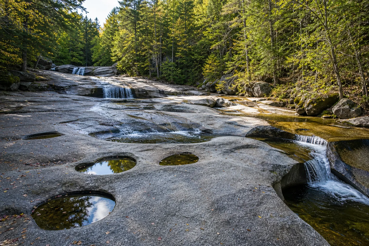
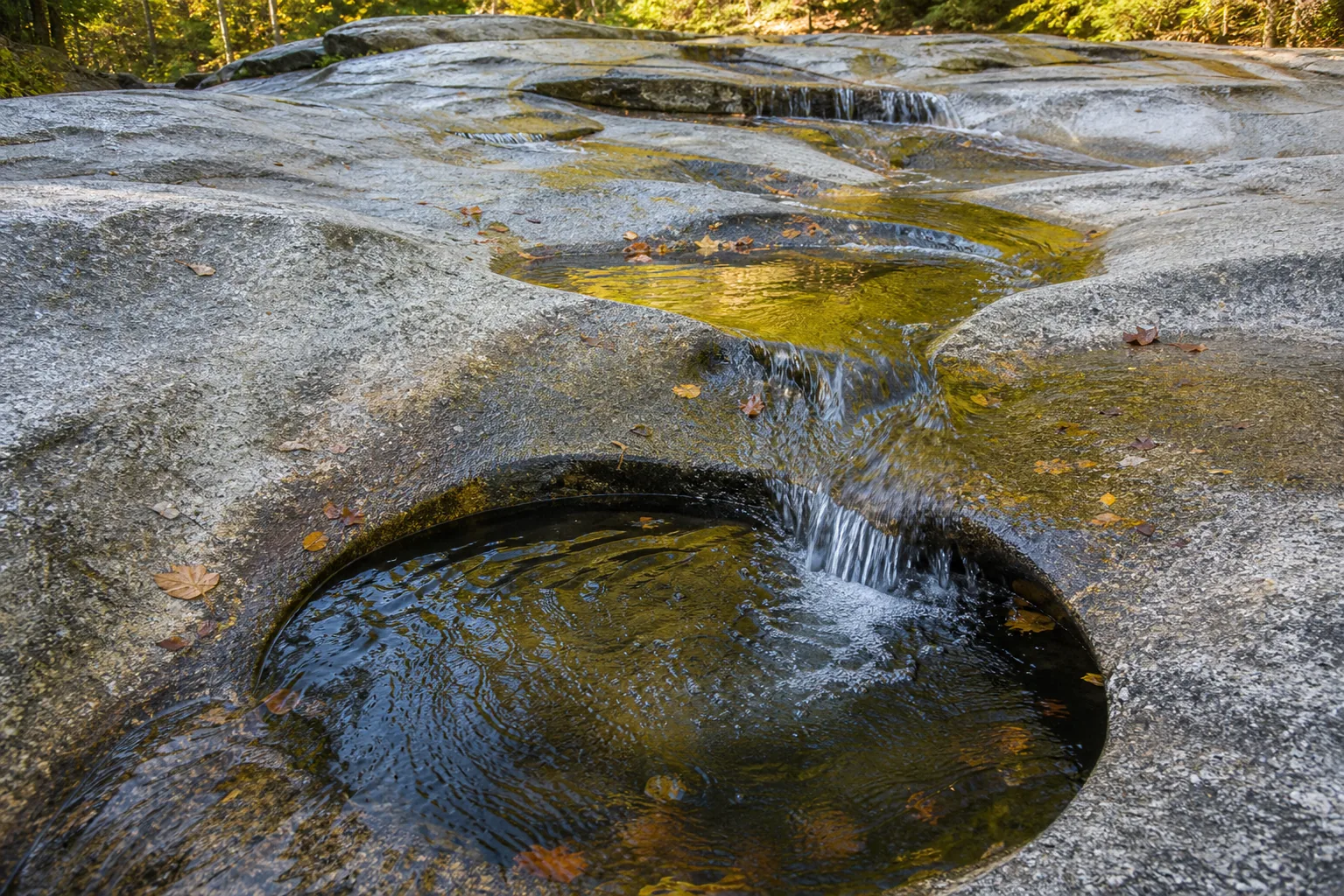
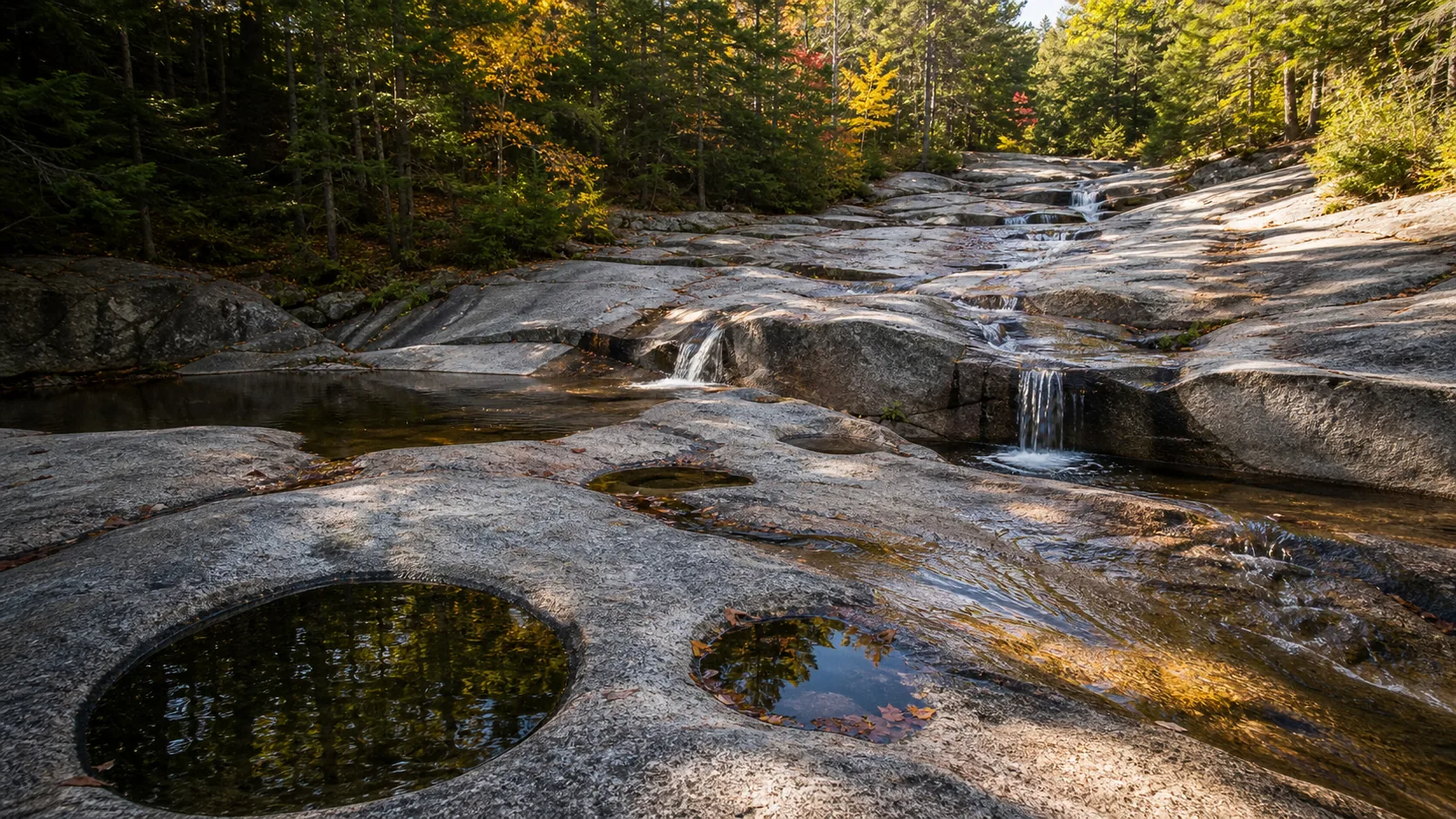
Yes, with planning. For swimming and pool play, mid-June through August is the window, with water in the low 60s F and pools shallow enough for kids but with one waist-deep tub near the upper cascades; for fall color, the first two weeks of October are reliable. Pay the $5 USFS day-use fee at the West Side Road lot, arrive before 9 a.m. on summer weekends or after 4 p.m., and skip altogether on Columbus Day weekend if you cannot get there at dawn.

  • 0.6 mi each way, flat gravel path
  • $5 USFS day-use parking
  • Lot fills by 9-10 a.m. summer weekends
  • Swim window: mid-Jun through Aug
  • Fall color: first two weeks of October
  • Stroller- and dog-friendly trail
Last verified May 12, 2026 Visited Desk-verified May 2026 7 sources checked
Distance 1.2 mi 5.0 mi extended
Round trip 30-90 min 0.6 mi each way on a flat, wide gravel path; near-ADA grade
Difficulty Easy 0.6 mi each way on a flat, wide gravel path; near-ADA grade
Location Bartlett, NH White Mountain National Forest
Parking $5 USFS day-use lot on West Side Road. Approximately 80 spaces. Fills by 9 to 10 a.m. on summer weekends and on October foliage Saturdays. USFS
Transit No fixed-route transit Drive only; nearest hub is North Conway village · 0 ft
Drive 4 mi 10 min from downtown
Best season Mid-Jun through Aug for swim; Oct for fall color Apr-May (snowmelt)
Diana's Baths base and water force
Photo guide

Five frames that show what the pools actually look like.

The cascading-pools shot from the footbridge, the close-up of water threading the sculpted Conway Granite, the wide setting view from the trail, the fall-color frame from the first week of October, and the spring-runoff frame when Lucy Brook is loudest. Use the captions to pick angles before you walk.

Diana's Baths waterfall and surrounding setting
Diana's Baths, hero composition
Diana's Baths wide setting view
Wide setting view
Diana's Baths base and water force
Base and water force
Diana's Baths water and rock detail
Water and rock detail
01Is Diana's Baths flowing right now?

This guide does not pair Diana's Baths with a verified real-time USGS discharge gauge because Lucy Brook is too small to be instrumented. For flow planning, use the NOAA/NWS forecast for Bartlett and the last 7 days of regional precipitation.

Diana's Baths has no paired USGS discharge gauge. The nearest proxy is the Saco River gauge in Conway, about 6 miles southeast on a much larger drainage; it tracks regional snowmelt and storm response but not Lucy Brook specifically. Use it as a directional read only.

02How long is the walk?

0.6 miles each way, 1.2 miles round trip, with about 62 feet of elevation gain. The path is a wide, hard-packed gravel surface on the northern terminus of the Moat Mountain Trail, used regularly by strollers and adaptive devices.

03How do you get there?

From North Conway village, follow River Road west across the Saco River, then turn north on West Side Road for about 2.5 miles. The signed USFS Diana's Baths trailhead and lot are on the left (west) side of the road. From Bartlett village, the lot is south on West Side Road.

04Is there free parking?

$5 USFS day-use fee per vehicle. The America the Beautiful Federal Recreation Pass is accepted. The lot holds roughly 80 cars and routinely fills by 9 to 10 a.m. on summer weekends and on October foliage Saturdays. Roadside parking on West Side Road is signed no-parking and is enforced. If the lot is full, the North Moat Trailhead about 1 mile north on West Side Road is a working alternative; it adds about 1.5 miles of forest walking each way before you reach the baths.

05Does it cost money?

$5 per vehicle USFS day-use fee or display of an America the Beautiful pass. The site is otherwise free to visit; there are no entrance fees, swim fees, or per-person charges.

06Trail variants

Diana's Baths out-and-back 1.2 mi round trip, 30-60 min, flat gravel path on the Moat Mountain Trail north terminus.
Family swim afternoon 1.2 mi plus pool time, 2-3 hr, lower pools are shallowest and most kid-friendly.
Moat Mountain Trail continuation 5 mi out-and-back to Big Attitash Mountain, 3-4 hr, real climb begins past the baths; not casual.
Fall color photo loop 1.2 mi, 60-90 min, early Oct mornings, before parking fills.

Detailed maps and recent reviews: Falls route on AllTrails · Creek route on AllTrails

07Can you swim?

Yes. Wading and swimming are allowed and tolerated by the Forest Service. The lower baths are knee- to thigh-deep and kid-friendly; the upper cascade tub is waist- to shoulder-deep and is the actual swim hole. Water stays cold (roughly 60 to 65 F in midsummer) because Lucy Brook is a small mountain stream. Granite is slick when wet; no lifeguards.

08Are dogs allowed?

Yes. Dogs are allowed on the Moat Mountain Trail and around the pools, under physical control (Forest Service rule). Most visitors keep dogs leashed on the busy gravel path; in-water play is permitted in the lower pools.

09Is it accessible?

The 0.6-mile gravel path is firm and nearly flat and is used routinely by strollers, wheelchair users with assistance, and adaptive devices. It is not formally ADA-certified. The granite ledges and pools themselves are uneven, slick when wet, and not wheelchair-accessible.

Field notes

Diana's Baths at a glance.

A 0.6-mile easy gravel walk on the northern Moat Mountain Trail to a staircase of pools and low cascades sculpted into Conway Granite on Lucy Brook, inside the White Mountain National Forest. $5 USFS day-use parking. Free to visit. Daylight use.

Height 75 ft USGS 3DEP
Type Cascades and sculpted granite pools USGS
Rock Conway Granite (White Mountain Magma Series) Conservative geology note
County Carroll Bartlett, NH
Managed by USDA Forest Service, White Mountain National Forest USFS
Water source Lucy Brook USGS
Elevation 656 ft USGS NED
Park area 800,000 acres USFS
Hours Daylight use; trailhead lot open year-round, snow-covered in winter USFS
When to visit

Two windows that justify the trip.

Mid-June through August for swimming and pool play, with water in the low 60s F and lower pools shallow enough for kids. The first two weeks of October for fall color, before Columbus Day weekend turns the lot into chaos. April through May is loudest for flow but the water is still snowmelt-cold and the trail is muddy.

PEAK FLOW

Peak flowApr-May (snowmelt)
Ice / low flowLate Dec-Mar
Most crowdedWeekends and midday
Best photosSunrise or weekdays

Live water context

Discharge data -- This guide does not pair Diana's Baths with a verified real-time USGS discharge gauge because Lucy Brook is too small to be instrumented. For flow planning, use the NOAA/NWS forecast for Bartlett and the last 7 days of regional precipitation.

Why is it called Diana's Baths?

The falls take their name from Diana, the Roman goddess of the hunt and the moon, who in classical art is often pictured bathing with her attendants in a forest pool. The naming dates to the 19th-century push by Mt. Washington Valley innkeepers and railroad boosters to give the region's natural features romantic, marketable labels for tourists arriving from Boston and New York. An older local name was Lucy's Bath, for Lucy Brook itself, which still names the stream that carves the pools.

What else to do at White Mountain National Forest

Diana's Baths sits inside the White Mountain National Forest, a 800,000-acre federal forest that covers most of north-central New Hampshire and a small slice of western Maine. The trailhead is on West Side Road in the village of Bartlett, about four miles from the tourist hub of North Conway at the south end of the Mt. Washington Valley. Most visitors base out of North Conway and treat Diana's Baths as a half-day stop on a longer valley itinerary that includes Cathedral Ledge, Echo Lake State Park, and the Kancamagus Highway.

  • The Lower Baths. The first set of pools you reach off the gravel trail, mostly knee- to thigh-deep, with the shallowest wading and the lowest-angle granite slabs. This is where families with small kids spend most of their time.
  • The Upper Cascades. A short rock scramble above the main pools, with a waist- to shoulder-deep tub that is the closest thing to a real swim hole on Lucy Brook. Slick rock; non-swimmers should stick to the lower pools.
  • Moat Mountain Trail. The same wide gravel path that gets you to the baths continues another 5 miles to Big Attitash Mountain. The casual day-use crowd turns around at the pools; the climb beyond is real.
  • Lucy Brook footbridge. The small wooden bridge below the main pools is the cleanest spot for the iconic cascading-pools photo and the only point where you can read the whole staircase of granite tubs at once.

Why it looks this way

The pools are sculpted into Conway Granite, a coarse pink-to-buff granite of the White Mountain Magma Series that intruded the region roughly 180 to 165 million years ago during Jurassic-age volcanic activity. The smooth, scalloped pools and tubs you see at the surface are plunge-pool potholes: Lucy Brook drives sand, gravel, and small cobbles in a tight circular grind at the base of each small cascade, and over thousands of years that grinding wears the granite into the rounded, bathtub-like depressions that give the falls their name. The Pleistocene glaciers that overrode the White Mountains until about 12,000 years ago first stripped the bedrock of soil and lubricated the surface; what you see now is post-glacial stream sculpting on a freshly exposed rock canvas.

Field guide deep dive

What you cannot tell from a White Mountain tourism listing.

The geology, the actual swim depth, the parking-lot rush, and the Mt. Washington Valley waterfall day. Skim the headers, read what you need.

How Diana's Baths formed

The bedrock at Diana's Baths is Conway Granite, a coarse-grained pink-to-buff granite that intruded the region as part of the White Mountain Magma Series during Jurassic-age volcanic activity roughly 180 to 165 million years ago. The same magma series produced the surrounding peaks of the Moat Range and much of the geology of the White Mountain National Forest. The granite is hard, but it is not uniformly hard; it has joint systems, slight chemical variations, and the kind of irregular surface that running water can exploit.

The pools you see today are plunge-pool potholes. At the base of each small cascade, Lucy Brook drives a load of sand, gravel, and small cobbles in a tight circular grind, the same way you would scour a pan with a wet stone. Over thousands of years that grinding wears the granite into the rounded, smooth-walled, bathtub-shaped depressions that named the falls. Each pool drains into the next, creating the staircase profile that reads so cleanly from the wooden footbridge.

The other key piece is the Pleistocene glaciation. Until about 12,000 years ago the Laurentide Ice Sheet covered the White Mountains, scraping soil and loose rock off the granite as it advanced and retreated. When the ice finally pulled back, what was left was a freshly stripped granite surface for the post-glacial streams to start working on. Diana's Baths is a textbook example of a small-stream sculpted-pool form on a young, glacier-prepped granite surface; it is not particularly old by waterfall standards, and the shapes are still actively changing.

The 0.6-mile walk and what is actually at the end of it

The trail from the West Side Road lot to the pools is 0.6 miles each way on a wide, hard-packed gravel surface that is the northern terminus of the Moat Mountain Trail. Elevation gain is about 62 feet over the full out-and-back; AllTrails rates it easy and most visitors complete the walk in 15 to 20 minutes each way. The path is firm enough for strollers, used regularly by wheelchair users with assistance, and dog-friendly under Forest Service voice-or-leash rules.

The trail crosses one small footbridge and passes a clearing on the old Lucy farm site before opening onto the granite ledges of the baths themselves. The first pools you reach are the lower baths: a series of low cascades and knee- to thigh-deep tubs spread across an open granite slab. This is where families with young kids spend most of their time. A short rock scramble upstream brings you to the upper cascades, where a waist- to shoulder-deep tub at the foot of the highest drop is the closest thing on Lucy Brook to a real swim hole.

Trail conditions are good year-round but change with the season. In April and May the path is muddy and the granite is cold and slick from snowmelt. From June through September the gravel is dry and the granite ledges are warm enough to sit on. In October the pools are too cold to swim but the foliage from the trailhead to the baths is the kind of saturated yellow and orange that defines the Mt. Washington Valley brand. In winter the trail is still passable with microspikes or snowshoes; Lucy Brook runs partly under ice and the pools rim-freeze without fully sealing.

Summer swim reality: pool depth, water temperature, current

Diana's Baths is the most famous family swimming hole in the Mt. Washington Valley because the lower pools are honestly kid-friendly. Most of the lower baths are knee- to thigh-deep, with the slabs angling gently into the water rather than dropping off. Toddlers can wade; six-year-olds can sit chest-deep in the deeper end of the lower run. There is one waist-to-shoulder-deep tub at the foot of the upper cascade that is the actual swim spot for older kids and adults.

Water temperature is the limit. Lucy Brook is a small mountain stream draining the Moat Range, so even in the warmest part of summer the pools hold in the low 60s F (roughly 16 to 18 C); on cool July mornings or after rain the water can drop into the high 50s. That is cold enough that most kids last 10 to 20 minutes before they want a sun-warmed slab to dry on. By mid-September the water is too cold for casual swimming; by October it is genuinely chilly.

Current is generally mild because the gradient is broken into so many short steps, but Lucy Brook does respond fast to rain. After heavy summer storms the cascades run noticeably louder and the upper tub develops a current that can knock small kids around. The Forest Service does not staff lifeguards and the granite is slick everywhere it is wet; the usual mountain-stream caution applies. If you want guaranteed warm water and lifeguards, Echo Lake State Park is 2.5 miles away.

The parking-lot problem and how to solve it

The most useful thing this guide can tell you about Diana's Baths is when the lot fills. The USFS day-use lot on West Side Road holds roughly 80 vehicles and charges $5 per car (cash or America the Beautiful pass). On a normal summer Saturday or Sunday, the lot is full by 9 to 10 a.m. and stays full until the late-afternoon families leave around 4. On October foliage Saturdays, especially Columbus Day weekend, the lot is often full by 8 a.m.

Roadside parking along West Side Road is signed no-parking and is regularly enforced with $30 to $50 tickets, so the practical strategies are: arrive before 9 a.m., arrive after 4 p.m., visit on a weekday, or use the North Moat Trailhead about 1 mile north on West Side Road. The North Moat lot is smaller and less obvious, holds about a dozen cars, and adds roughly 1.5 miles of forest walking each way before you reach the baths from the north side. It is the most useful overflow option and most summer-weekend visitors do not know it exists.

If the entire West Side Road corridor is full, the right answer is to flip the itinerary and run Arethusa Falls first, then come back to Diana's Baths in the late afternoon when the morning families clear out. The drive between the two trailheads is about 30 minutes via US-302 through Crawford Notch.

A Mt. Washington Valley waterfall day from a North Conway base

Diana's Baths reads best as part of a longer Mt. Washington Valley itinerary rather than a destination on its own. From a North Conway base, the obvious pairing is Arethusa Falls, the tallest single-drop waterfall in New Hampshire, about 30 minutes northwest on US-302 inside Crawford Notch State Park. Arethusa is a real hike (2.8 miles round trip, 850 feet of elevation gain) and is best paired with the gentler Diana's Baths walk for a full waterfall day rather than two demanding ones.

A working morning-to-evening route: start at Arethusa at first light for the cool air and the soft east light on the cliff, drive back south on US-302, pick up lunch in North Conway, then walk the Diana's Baths gravel path in the early afternoon when the lower pools have cleared a bit. Add Cathedral Ledge and Echo Lake State Park if you have extra time; both are minutes from the Diana's Baths trailhead. For an even longer day, the Kancamagus Highway south of North Conway adds Sabbaday Falls and Lower Falls along NH-112.

Most visitors base out of North Conway because it concentrates the lodging, restaurants, and outdoor-gear shops within a short drive of the trailheads. Bartlett village itself, 4 miles closer to the Diana's Baths lot, is quieter and works well for travelers who want to skip the outlet-shopping side of North Conway. The Saco River runs between the two and is the regional landscape spine; the same drainage that carves Diana's Baths via Lucy Brook eventually feeds the Saco below North Conway.

Photography practical: the cascading-pools shot

The defining frame at Diana's Baths is the wide-angle read of the full pool staircase from the small wooden footbridge below the lower baths. It is the one position where the whole sequence of cascades and tubs lines up, and it is the shot that has carried the site through a century of New Hampshire tourism postcards. A 24mm to 35mm equivalent on a full-frame body, or any phone wide lens, handles it cleanly.

The Conway Granite is light pink to buff and blows out fast under direct sun, so the workable light is overcast, early morning before the sun clears the hemlocks (the pools are in tree shadow until about 10 a.m. in summer), or the last hour of the day. A polarizer cuts the surface glare on the pools and lets you read the granite texture under the water; a neutral-density filter long enough to drag the shutter past a second renders the cascades as smooth white ribbons, which suits the bathtub-pool form better than freezing the spray. In October the same frame doubles as a fall-color shot when the yellow birch and sugar maple along Lucy Brook turn.

For close-ups, the water-and-rock detail at the upper cascade is the second-strongest set: backlit threads of water threading scalloped pink granite, shot at a longer focal length from a granite slab off-axis. Avoid drones; they are discouraged at busy USFS day-use sites and the trees would block most useful angles anyway.

Map and route

Four miles west of North Conway on West Side Road.

From North Conway village, follow River Road west across the Saco River, then turn north on West Side Road for about 2.5 miles. The signed USFS Diana's Baths trailhead and lot are on the left (west) side of the road. From Bartlett village, the lot is south on West Side Road.

Photography and weddings

Wide-angle granite, overcast light, no drones.

Diana's Baths is a wide-angle scene, not a single-curtain waterfall. The defining frame is the full staircase of pools and low cascades read from the wooden footbridge or from the granite slabs just below the lower baths. The water-and-rock detail shots, where backlit water threads over scalloped pink granite, are the second strongest set.

Overcast or open-shade light is best because the Conway Granite is light pink to buff and blows out under direct midday sun, especially in summer. Early morning before the lot fills and the last hour of light through the hemlocks both work, but the pools are deep in tree shadow until about 10 a.m.

Casual personal photography is permitted in the White Mountain National Forest without a permit. Commercial shoots, weddings, drones, and any setup that blocks the trail or pools require Forest Service permission and may incur a special-use permit fee.

Permits

Weddings and engagements

Diana's Baths is informally popular for engagement photos in shoulder season but is not practical for ceremonies. The trail is narrow, the pools are crowded in summer, and there is no event infrastructure of any kind.

Any ceremony, commercial shoot, or staged session on National Forest land requires a USFS special-use permit. Apply through the White Mountain National Forest supervisor's office at least 90 days ahead.

If you want the cascading-pools backdrop, plan for a weekday in mid-October before 9 a.m., keep the party under six people, and have a North Conway indoor backup ready for weather.

Nearby waterfalls

A Mt. Washington Valley waterfall day.

Diana's Baths pairs naturally with Arethusa Falls, the tallest single-drop waterfall in New Hampshire and a 30-minute drive northwest on US-302 in Crawford Notch State Park. Both sit inside the White Mountain National Forest, both are easy enough for a casual day, and the two together fill a full morning-to-late-afternoon waterfall route from a North Conway base.

Related questions

More questions visitors ask before driving to Diana's Baths.

Hike distance, swim depth, parking, dogs, accessibility, and the worth-visiting question. The full set is also indexed in the FAQ schema for AI answer engines.

01How deep are the pools at Diana's Baths?

Most of the lower baths are knee- to thigh-deep, with gently angled granite slabs that suit wading toddlers and young kids. One pool at the foot of the upper cascade is waist- to shoulder-deep and is the only spot deep enough for an adult to actually swim a stroke or two.

02Is Diana's Baths worth visiting?

Yes, with planning. For families with young kids in summer, it is the single best swim-hole walk in the Mt. Washington Valley: short flat trail, $5 parking, shallow pools, no other commitments. For October fall color, the first two weeks are reliable and quieter than Crawford Notch. The single failure mode is arriving on a summer Saturday at 11 a.m. and finding the lot full; the lot fills by 9 to 10 a.m. on those days.

Sources and data

Where this Diana's Baths guide gets its facts.

Trail and parking facts from the USDA Forest Service White Mountain National Forest page. Geology from the New Hampshire Geological Survey on the White Mountain Magma Series. Etymology cross-referenced with the Wikipedia article on Diana's Baths and regional New England travel writing. Weather grid from NOAA NWS Gray, ME (GYX).

USFS: White Mountain National Forest fs.usda.gov
Access, parking, and permit rules: fs.usda.gov
Conservative geology note: Bartlett bedrock northconwaynh.com
NOAA/NWS forecast grid GYX/39,71 noaa.gov
USGS National Elevation Dataset 3DEP
Google Maps: embedded map and directions maps.google.com
Google Places: nearby restaurants and hotels places API
Wikimedia Commons - Diana's Baths images commons.wikimedia.org
NOAA/NWS forecast grid weather.gov
SERP reference - northconwaynh.com northconwaynh.com
SERP reference - tripadvisor.com tripadvisor.com
SERP reference - alltrails.com alltrails.com
Fact checks
Keyword pass: page targets Diana's Baths guide, Diana's Baths trail, Diana's Baths photos, Diana's Baths map, parking, directions, and best time to visit.
Photo audit: waterfall slots use exact Wikimedia Commons files matched to Diana's Baths; unrelated park context photos are excluded from waterfall slots.
Flow audit: no live flow chip is shown unless a gauge is manually paired and verified.
Access audit: fee, swimming, dog, and accessibility copy is conservative unless the page has a specific source.
Corrections: [email protected]