Arethusa Falls waterfall and surrounding setting
Harts Location, NH

Arethusa Falls

Arethusa Falls is a 140-foot horsetail on Bemis Brook in Crawford Notch State Park, reached by a 2.6-mile out-and-back trail with about 900 feet of climbing from the US-302 trailhead. It is widely cited as one of the tallest single-drop waterfalls in New Hampshire, and the most popular waterfall hike in the White Mountains south of Franconia Notch.

Last verified May 12, 2026 Visited Desk-verified May 2026 7 sources checked
Trail 2.6 mi 4.7 mi extended
Time 120-240 min Moderate
Best season May-October; winter possible with microspikes Late April through mid-May (snowmelt)
Parking Free trailhead lot off US-302 (about 30 spaces); fills by 9am on summer and fall weekends Crawford Notch State Park
Quick answer

Is Arethusa Falls worth visiting?

Yes, with one caveat: it is a real hike, not a drive-up stop. The strongest windows are May and June for high snowmelt flow, late September through mid-October for foliage, and February for the ice-climb spectacle if you have microspikes. Free state park, day-use only, free trailhead lot off US-302 that fills by 9am on summer and fall weekends.

  • 2.6 mi out-and-back, about 900 ft of gain
  • 140 ft horsetail on Bemis Brook
  • Free state park, free lot off US-302
  • Peak flow: late April through May
  • Foliage: late Sep through mid-Oct
  • Winter: microspikes required, ice-climb route forms
Last verified May 12, 2026 Visited Desk-verified May 2026 7 sources checked
Distance 2.6 mi 4.7 mi extended
Round trip 120-240 min About 900 ft of elevation gain, mostly uphill on the way to the falls, with rocks and roots throughout
Difficulty Moderate About 900 ft of elevation gain, mostly uphill on the way to the falls, with rocks and roots throughout
Location Harts Location, NH Crawford Notch State Park
Parking Free trailhead lot off US-302 (about 30 spaces); fills by 9am on summer and fall weekends NH State Parks
Transit No fixed-route transit Drive only; Arethusa Falls Trailhead on US-302 · 0 ft
Drive 10 mi 15 min from downtown
Best season May-October; winter possible with microspikes Late April through mid-May (snowmelt)
Arethusa Falls the base of arethusa falls where bemis brook lands on the granite slab and breaks into spray
Photo guide

Four working positions on a 140-foot horsetail.

The hike is two and a half miles. The frames here are what you carry back: the wide shot from the base scramble, the rock-channel detail at the lip, the tree-framed shoulder from the Frankenstein cutoff, and the steep cathedral angle from the boulder field.

Arethusa Falls waterfall and surrounding setting
Arethusa Falls, hero composition
Arethusa Falls 140-foot horsetail drop over Conway Granite seen from the trail's end viewing area
The full 140-foot horsetail seen from the standard viewing rock at the base of the falls
Arethusa Falls base on Bemis Brook with spray on granite slab below the 140-foot drop
The base of Arethusa Falls where Bemis Brook lands on the granite slab and breaks into spray
Close detail of Arethusa Falls water sliding over Conway Granite in a thin horsetail sheet
Water-on-Conway-Granite detail showing the thin braided sheet that gives the falls its horsetail signature
01Is Arethusa Falls flowing right now?

This guide does not currently pair Arethusa Falls with a verified real-time USGS discharge gauge because no gauge exists on Bemis Brook. The flow chip is intentionally hidden; use recent rain totals as the practical proxy.

Arethusa Falls has no paired live USGS gauge on Bemis Brook. Use the NWS forecast grid linked on this page for the most recent rain totals at Crawford Notch and treat the falls as high for the two weeks after a heavy rain or during late-April snowmelt; treat it as thin in late August through early October if there has been no recent rain.

02How long is the walk?

The Arethusa Falls Trail is 2.6 miles out and back with about 900 feet of elevation gain. The climb is steady but not severe; the trail is rocky and root-laced throughout with no scrambling. Most fit visitors take 2 to 3 hours round trip including time at the falls. Add 30 minutes if you take the Bemis Brook spur.

03How do you get there?

Trailhead is on Arethusa Falls Road, a short paved access road off US-302 in Harts Location, about 10 minutes north of Bartlett and 25 minutes northwest of North Conway. Google Maps and the NH State Parks page both pin the trailhead correctly. There is no public transit; this is a drive-only destination.

04Is there free parking?

Free dirt lot at the trailhead with about 30 spaces, plus overflow on the shoulder of Arethusa Falls Road. The lot fills by 9am on summer weekends and any October foliage weekend; the overflow shoulder fills shortly after. There is no overnight parking, and the lot is unplowed in winter (park in the small US-302 pullout instead).

05Does it cost money?

Free. Crawford Notch State Park does not charge an entrance or day-use fee for the Arethusa Falls Trailhead. No NH State Parks pass, federal pass, or reservation is required. The only optional costs are food at the Willey House snack bar and lodging in Bartlett or North Conway.

06Trail variants

Arethusa Falls out-and-back 2.6 mi round trip, 2-3 hr, primary route, about 900 ft of elevation gain.
Bemis Brook Trail spur adds about 0.3 mi, +30 min, passes Bemis Falls, Coliseum Falls, and Fawn Pool on the lower section.
Arethusa Falls and Frankenstein Cliff Loop 4.7 mi loop, 4-5 hr, full-day option with about 1,500 ft of gain and exposed cliff-top views.
Winter route 2.6 mi round trip, 3-4 hr, microspikes essential; trail freezes solid and the falls forms an ice climb.

Detailed maps and recent reviews: Falls route on AllTrails · Creek route on AllTrails

07Can you swim?

There is no real swimming hole at Arethusa Falls. The plunge pool is shallow and the granite slab around it is slick. Wading is informally tolerated on hot summer days, but treat the rock as hazardous and do not climb into the spray zone.

08Are dogs allowed?

Yes, on leash. Dogs are allowed throughout Crawford Notch State Park and on the Arethusa Falls Trail. Bring water (Bemis Brook is clean but the climb is hot in July) and watch paws on the rocky upper section.

09Is it accessible?

Not accessible. The Arethusa Falls Trail is a 1.3-mile rocky climb each way with no paved alternative, lower viewpoint, or roadside view of the falls. For an accessible Crawford Notch waterfall stop, use the Silver Cascade and Flume Cascade pullouts further north on US-302, both step-free from the road shoulder.

Field notes

Arethusa at a glance.

140 feet, horsetail on Conway Granite of the White Mountain Magma Series, 2.6 miles round trip with about 900 feet of climb, managed by New Hampshire State Parks inside Crawford Notch State Park. Sourced from the NH State Parks Crawford Notch page and USFS White Mountain NF.

Height 140 ft USGS 3DEP
Type Horsetail (single tier) USGS
Rock Conway Granite (White Mountain Magma Series) Conservative geology note
County Carroll Harts Location, NH
Managed by New Hampshire State Parks NH State Parks
Water source Bemis Brook USGS
Elevation 2205 ft USGS NED
Park area 5,950 acres NH State Parks
Hours Trailhead accessible 24 hours; day-use only, no overnight parking NH State Parks
When to visit

Spring runoff, autumn color, or microspike winter.

Late April through May for the loudest flow, the third week of September through mid-October for foliage in the notch, and January through February for the iced cathedral if you bring traction. The seasonal read and the NWS forecast on the right tell you which one you are walking into today.

PEAK FLOW

Peak flowLate April through mid-May (snowmelt)
Ice / low flowLate December through March
Most crowdedWeekends and midday
Best photosSunrise or weekdays

Live water context

Discharge data -- This guide does not currently pair Arethusa Falls with a verified real-time USGS discharge gauge because no gauge exists on Bemis Brook. The flow chip is intentionally hidden; use recent rain totals as the practical proxy.

Why is it called Arethusa Falls?

The falls is named after Arethusa, a nymph in Greek mythology who was pursued by the river god Alpheus and turned into a freshwater spring by the goddess Artemis to protect her. The naming is a 19th-century romantic touch typical of New England's golden age of mountain tourism, when Crawford Notch was promoted as the American answer to the Alps and surveyors borrowed classical names freely.

The brook itself, Bemis Brook, is named for Dr. Samuel Bemis, the Boston dentist and amateur photographer who built the granite Notchland estate (now the Notchland Inn) just downstream on US-302 in the 1860s. The Bemis name predates the Arethusa name on local maps.

What else to do at Crawford Notch State Park

Crawford Notch State Park is a 5,950-acre state park strung along US-302 between Bartlett and the village of Crawford Notch, with the Bemis Brook drainage and Arethusa Falls forming its waterfall headliner. The standard pairing is the 2.6-mile Arethusa Falls Trail with an optional add-on across the Frankenstein Cliff Loop (about 4.7 mi total), and the closest base towns are Bartlett (10 minutes south) and North Conway (25 minutes southeast).

  • Arethusa Falls Trail. 1.3 mi each way, about 900 ft of elevation gain, rocks and roots throughout. The most popular waterfall hike in Crawford Notch and a regular AllTrails top-rated route in New Hampshire.
  • Bemis Brook Trail. Optional lower-elevation spur that branches off the main trail and passes Bemis Falls, Coliseum Falls, and Fawn Pool before rejoining. Adds about 0.3 mi and another 30 minutes; closes informally in wet conditions because the brook crossings flood.
  • Frankenstein Cliff Loop. The full-day option that ties Arethusa to the cliff-top traverse and the Conway Scenic Railroad trestle view. About 4.7 mi total, 1,500 ft of gain, steeper grades than the falls trail.
  • Silver Cascade and Flume Cascade. Two drive-up roadside falls a few minutes further north on US-302, both inside the same state park. The natural Crawford Notch waterfall day is Arethusa first, then both roadside falls on the return drive.
  • Willey House Historic Site. The 1825 landslide site in the heart of the notch, with a small visitor center, restrooms, and a snack bar (seasonal). The only reliable bathroom stop between Bartlett and the Highland Center.

Why it looks this way

Arethusa Falls drops over a cliff of Conway Granite, the pink-to-buff intrusive rock that defines the southern White Mountains and was emplaced about 180 million years ago as part of the White Mountain Magma Series. The cliff face is a Pleistocene glacial cut: the Bemis Brook valley was overdeepened by ice during the last glaciation, leaving the hanging tributary now drained by Bemis Brook. A horsetail shape develops here because the brook stays in contact with the rock face for most of the drop rather than free-falling, which is what you get when the cliff is just slightly off-vertical and the discharge is modest relative to the cliff height.
Field guide deep dive

What the NH State Parks listing leaves out.

How much elevation you actually climb, where the tallest-in-NH claim stands, the Frankenstein Cliff add-on, the winter ice-climb route, and which other Crawford Notch falls to chain into the same day.

How Arethusa Falls formed

Arethusa Falls drops over a cliff of Conway Granite, the pink-to-buff intrusive rock that defines the southern White Mountains. The Conway Granite is part of the White Mountain Magma Series, a sequence of plutonic and volcanic rocks emplaced into the older bedrock of New England roughly 180 to 100 million years ago during the Mesozoic. The magma series produced the ring-dike complexes that today form Mount Washington and the Presidential Range to the north, the Ossipee Mountains to the south, and the Crawford Notch cliffs that hold Arethusa.

The cliff face you see from the viewing rock is not the result of slow stream erosion. The Bemis Brook valley was carved by continental ice during the most recent (Wisconsinan) glaciation, which ended about 12,000 years ago. The main glacier ran north to south through the larger Saco River valley and overdeepened it relative to its tributaries, leaving the Bemis Brook drainage as a classic hanging valley. When the ice retreated, Bemis Brook was left flowing off the lip of that hanging valley into the deeper main trough below, and Arethusa Falls is the result.

A horsetail shape develops here, rather than a free-falling plunge, because the cliff is just slightly off-vertical and the brook's discharge is modest relative to the cliff height. The water stays in contact with the granite face through most of the 140-foot drop, fans out in a thin sheet at the top, and breaks into spray as it picks up speed. In high water the sheet thickens until it briefly resembles a plunge; in late summer it splits into several ribbons.

Is Arethusa actually the tallest waterfall in New Hampshire?

The honest answer: probably yes for a single continuous drop, but the heights are disputed and the field is crowded. The Visit New Hampshire and Visit White Mountains tourism listings call Arethusa New Hampshire's tallest waterfall and quote 160 feet. The Wikipedia article and Reddit's r/wmnf community both cite 140 feet. The onX Maps trail database splits the difference and lists "between 140 and 200 feet." The most-cited modern figure on signage and in guidebooks is 140 ft, which is what this guide uses.

The ranking depends on how you count. Beecher Cascades in Crawford Notch is taller in total drop but is a multi-tier cascade, not a single fall. Glen Ellis Falls in Pinkham Notch is a thunderous 64-foot plunge that is shorter but much more powerful. Ripley Falls, a half-mile away from Arethusa in the same state park, is a 100-foot horsetail of the same general shape. Crystal Cascade on the Tuckerman Ravine Trail drops about 80 feet in two tiers. Arethusa wins on uninterrupted single-drop height; it loses on volume and on power.

The other honest qualifier: heights at White Mountain falls were historically measured by sighting and by counting rope lengths during 19th-century surveys, and the modern numbers are mostly inherited rather than re-measured by lidar. A 2017 Woodlands and Waters field write-up estimated Arethusa at "approximately 176 feet," closer to the older Visit NH number. None of the published sources cite a modern instrument survey. Treat 140 feet as the conservative baseline and the higher numbers as plausible.

The 2.6-mile climb, in practical terms

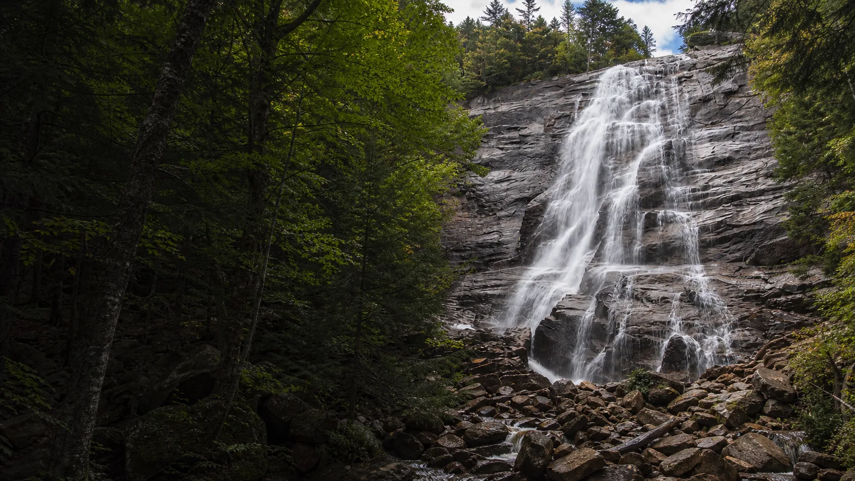
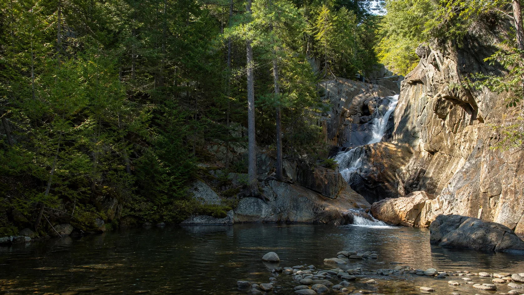
The Arethusa Falls Trail is 2.6 miles out and back with about 900 feet of elevation gain, almost all of it on the way to the falls. From the US-302 trailhead the route climbs gradually through hardwood and then hemlock forest, crossing several drainages on small log bridges, and gets steeper in the last quarter mile before delivering you to a large granite viewing rock at the base of the falls.

It is a real hike, not a roadside stop. The grade averages about 700 feet per mile on the steeper second half, which is moderate by White Mountain standards but enough to slow children under about eight and adults who are not used to hill climbing. The tread is mostly rocks and roots, with no scrambling and no exposure. Trail runners and athletic kids handle it in about 90 minutes round trip; an average pace is two and a half to three hours, including time at the falls.

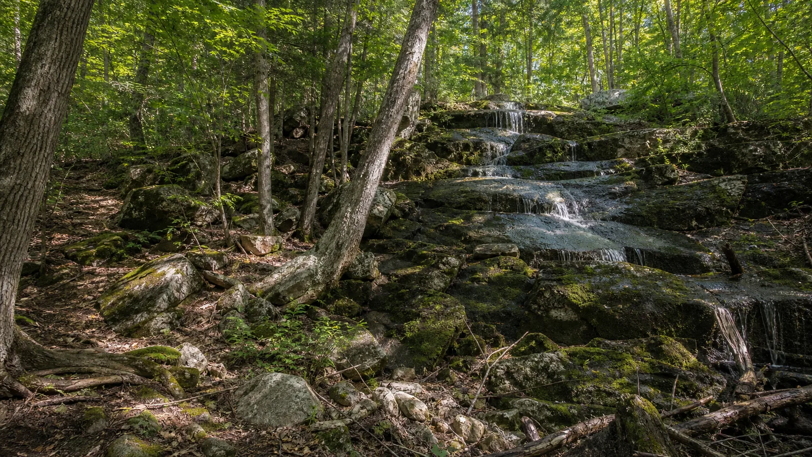
The optional Bemis Brook Trail spur on the lower section adds about 0.3 mi and visits Bemis Falls, Coliseum Falls, and Fawn Pool before rejoining the main trail. It is worth the extra time in moderate-flow conditions; skip it in high water because the brook crossings flood. Many parties take it on the way down for the gentler grade.

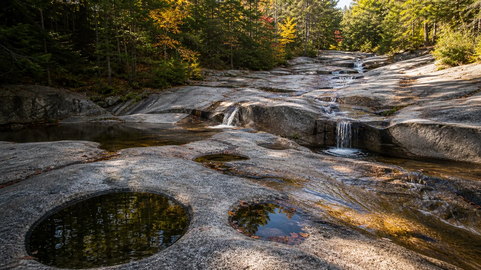
For families with older kids who are used to walking, Arethusa is doable; for families with young children, the Diana's Baths trail (also White Mountain National Forest, ten minutes by car each way and 80 feet of total gain) is the better choice. See our Diana's Baths guide for the comparison.

The Frankenstein Cliff loop add-on

The standard upgrade is the Arethusa Falls and Frankenstein Cliff Loop, which ties the falls trail to a cliff-top traverse and the Conway Scenic Railroad trestle view. It is the AllTrails-listed full-day variant for visitors who want more than a falls-and-back. The loop runs about 4.7 miles total with about 1,500 feet of elevation gain and takes most parties four to five hours.

The standard direction is counterclockwise: hike up to Arethusa Falls first, continue on the Arethusa-Ripley Falls Trail to the Frankenstein Cutoff, traverse north along the Frankenstein Cliff Trail (the cliff-top section has open ledge views of Crawford Notch and the Mount Washington Hotel in the distance), and descend back to US-302 via the trestle underpass. There is about a half-mile of road walking back to the trailhead at the end.

The Frankenstein side is steeper than the Arethusa side and the cliff-top section is exposed enough that it should be avoided in wet weather or on icy days. It is the better choice for visitors who want trail variety and a non-waterfall view of the notch; it is the worse choice for a first-time visit if Arethusa itself is the goal, because the loop adds two hours and a steep descent for an experience that is more cliff than waterfall.

A Crawford Notch waterfall day

The natural Crawford Notch waterfall itinerary chains Arethusa with two roadside falls further north on US-302, all inside the same state park. After the Arethusa hike, drive about 5 miles north to the Silver Cascade pullout. Silver Cascade is a 250-foot multi-tier cascade visible from the road shoulder, and it is the easiest big-name waterfall in the notch: no hike, no parking fee, no trail.

Half a mile further north is Flume Cascade, a 250-foot ribbon down a parallel cliff. Both are step-free from the road. From the Flume Cascade pullout, the village of Crawford Notch is two minutes north; the Highland Center (AMC lodge with cafeteria) is a reliable food stop if you skipped Willey House.

If you want a full White Mountains waterfall day rather than just Crawford Notch, add Diana's Baths in North Conway on the way home; the trailhead is 25 minutes south of Arethusa and adds an easy 1.4-mile flat walk to a chain of small ledge falls in Lucy Brook. See our Diana's Baths guide for trail and parking details.

Winter access and the ice-climb route

The Arethusa Falls Trail does not officially close in winter, but it changes character completely. From late December through March the trail freezes hard, the rocks and roots disappear under packed snow, and the steeper second half becomes a sustained icy grade. Microspikes or full traction are required; trekking poles help. Snowshoes are sometimes needed after fresh snow but the route packs out quickly because it is the most popular winter waterfall hike south of Franconia.

The falls itself freezes into a multi-pitch ice climb in most winters. The standard line is rated WI3 to WI4 by the Mountain Project community and is a popular New England intermediate route. Casual visitors should stay back from the base in winter because of falling ice and the climbers' rope lines; the standard viewing rock is the right place to watch from, not the bottom of the climb.

The lot at the trailhead is unplowed; park in the small US-302 pullout instead and walk in. Sunset in January is at about 4:30 p.m., so start the round trip by noon if you want light at the falls. Cell service is unreliable in the notch; tell someone your plan before you go.

Map and route

Off US-302, twenty minutes north of Bartlett.

Trailhead is on Arethusa Falls Road, a short paved access road off US-302 in Harts Location, about 10 minutes north of Bartlett and 25 minutes northwest of North Conway. Google Maps and the NH State Parks page both pin the trailhead correctly. There is no public transit; this is a drive-only destination.

Photography and weddings

North-facing curtain, two-mile climb, no commercial permit on park land.

The standard frame is from the large granite viewing rock at the trail's end, about 80 feet from the base of the falls. There are also two photo positions on the way up: the Bemis Brook spur views (Bemis Falls and Coliseum Falls), and a quick side glance from the boulder field about 0.2 mi below the falls. Mist reaches the viewing rock in high water; bring a lens cloth in May and June.

The cliff faces roughly southeast, so morning light hits the falls head-on and is the cleanest light of the day. By mid-afternoon the cliff is in its own shadow and contrast collapses, which is fine for a moody frame but flat for a hero shot. Overcast days are the safest exposure because the white water and the darker pink granite both keep detail.

Personal photography from public viewpoints does not require a permit. Commercial productions, drones, and any setup that blocks the viewing rock require written permission from NH State Parks.

Permits

Weddings and engagements

Arethusa is not a practical ceremony venue: the trail is a 1.3-mile climb each way, the viewing area is a single granite slab, and weekend crowds are heavy. It can work as an engagement-photo backdrop for fit couples willing to hike, but plan early weekday mornings.

Contact NH State Parks before any organized group session at Arethusa Falls. Drones are prohibited without a written permit.

Keep groups small, hike out before midday weekend crowds arrive, and have a backup plan: the Silver Cascade roadside pullout further north on US-302 is the standard fallback for accessible Crawford Notch portraits.

Related questions

More questions visitors ask before driving to Arethusa.

Tallest-in-NH framing, dog policy, winter gates, and the actual time budget for the climb. All entries also index in the FAQ schema for AI answer engines.

01How do you get to Arethusa Falls?

Use the map for orientation, then verify the current Arethusa Falls trailhead, parking area, and legal public access before driving.

02What is the best time to visit Arethusa Falls?

The best time to visit Arethusa Falls is usually late spring through fall, with winter ice possible, with overcast light often best for photos.

03Are the photos on this page really Arethusa Falls?

Yes. The photo set is selected to match Arethusa Falls, and the photo audit keeps unrelated park-context images out of the waterfall slots.

04Is Arethusa Falls good for families?

Arethusa Falls can be a good family stop when the official route is open and conditions are dry, but check distance, barriers, footing, and water safety first.

Sources and data

Where the Arethusa guide gets its facts.

Park rules from NH State Parks Crawford Notch. Geology from NH Geological Survey on the White Mountain Magma Series. Trail measurements from USFS White Mountain National Forest. Etymology from the Greek-mythology entry on Arethusa cross-checked against early 20th-century White Mountains travel writing.

NH State Parks: Crawford Notch State Park nhstateparks.org
Access, parking, and permit rules: nhstateparks.org
Conservative geology note: Harts Location bedrock alltrails.com
NOAA/NWS forecast grid GYX/31,73 noaa.gov
USGS National Elevation Dataset 3DEP
Wikidata: Q4789853 (Arethusa Falls) wikidata.org
Google Maps: embedded map and directions maps.google.com
Google Places: nearby restaurants and hotels places API
Wikimedia Commons - Arethusa Falls images commons.wikimedia.org
NOAA/NWS forecast grid weather.gov
SERP reference - alltrails.com alltrails.com
SERP reference - visitwhitemountains.com visitwhitemountains.com
SERP reference - tripadvisor.com tripadvisor.com
Fact checks
Keyword pass: page targets Arethusa Falls guide, Arethusa Falls trail, Arethusa Falls photos, Arethusa Falls map, parking, directions, and best time to visit.
Photo audit: waterfall slots use exact Wikimedia Commons files matched to Arethusa Falls; unrelated park context photos are excluded from waterfall slots.
Flow audit: no live flow chip is shown unless a gauge is manually paired and verified.
Access audit: fee, swimming, dog, and accessibility copy is conservative unless the page has a specific source.
Corrections: [email protected]