Benham Falls waterfall and surrounding setting
Sunriver, OR

Benham Falls

Benham Falls is not a tall plunge waterfall. It is a roughly 25-foot Class V rapid and cascade complex where the upper Deschutes River drops through a narrow basalt gorge between Sunriver and Bend, Oregon. The gorge sits at the upstream edge of a 6,000-year-old Lava Butte basalt flow, and the easiest viewpoint is a flat 0.7-mile walk from the Benham Falls East Day Use trailhead in the Deschutes National Forest.

Last verified May 4, 2026 Visited Desk-verified May 2026 5 sources checked
Trail 1.4 mi Round-trip route varies
Time 30-60 min Easy
Best season March through May for peak flow from rain and snowmelt; April through November for the best overall conditions After rain or snowmelt
Parking Day-use lot, $5 per vehicle Benham Falls East Day Use Area, Deschutes National Forest
Quick answer

Is Benham Falls worth visiting?

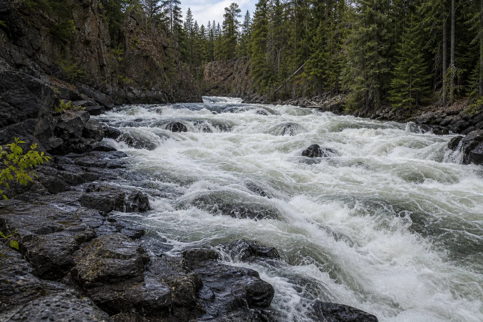
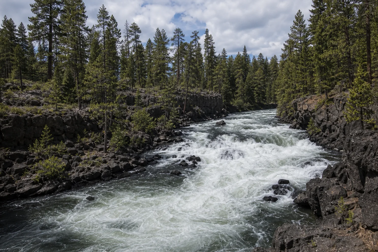
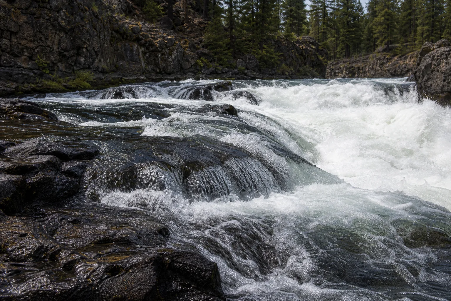
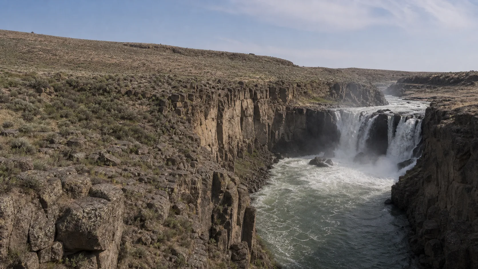
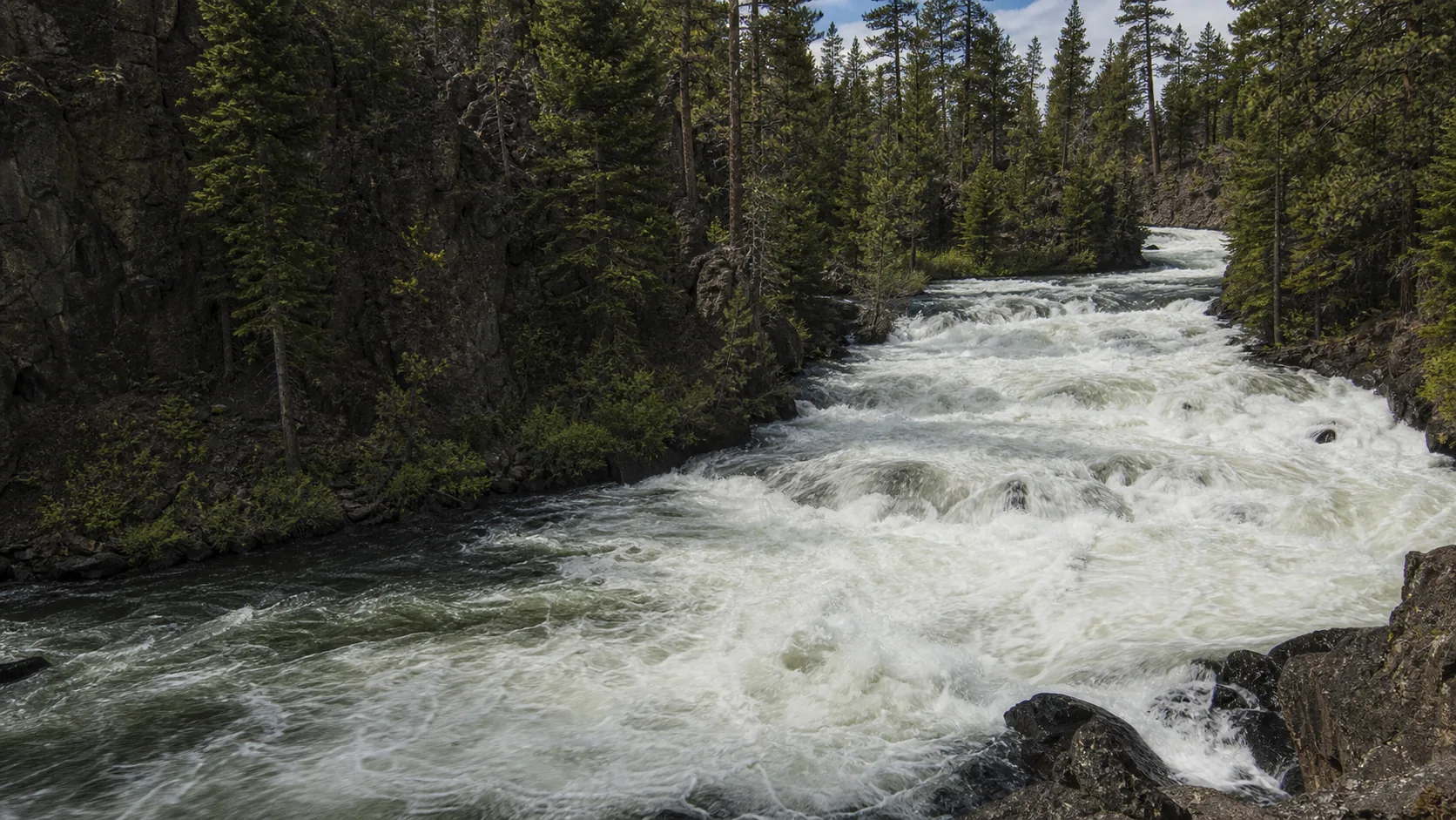
Yes, for a fast, fact-rich Central Oregon stop: a flat 0.7-mile walk through old-growth ponderosa pine ends at signed overlooks above a Class V rapid that runs at a 22.5-degree pitch through a narrow basalt gorge. The trail is open year-round, with peak whitewater volume between March and May as Cascade snowmelt pushes the upper Deschutes to its annual high. Parking requires a $5 day-use fee, covered by a Northwest Forest Pass or America the Beautiful Interagency Pass; there is no staffed entry station beyond that.

  • 0.7 mi one way (1.4 mi round trip) on a flat Deschutes River Trail
  • $5 per vehicle per day; Northwest Forest and Interagency passes accepted
  • Open 30 min before sunrise to 30 min after sunset, year-round
  • 25-foot cascade, 40 feet wide, Class V rapid; no swimming
  • Leashed dogs welcome; mandatory leash May 15-Sept 15 on the river trail
  • Mosquitoes are heavy May through early July; bring repellent
Last verified May 4, 2026 Visited Desk-verified May 2026 5 sources checked
Distance 1.4 mi Loop distance varies
Round trip 30-60 min 0.7 miles one way (1.4 mi round trip) on a mostly flat forest trail through ponderosa pine along the Deschutes River; signed overlooks of the 25-foot falls
Difficulty Easy 0.7 miles one way (1.4 mi round trip) on a mostly flat forest trail through ponderosa pine along the Deschutes River; signed overlooks of the 25-foot falls
Location Sunriver, OR Benham Falls East Day Use Area, Deschutes National Forest
Parking Day-use lot, $5 per vehicle U.S. Forest Service
Transit No fixed-route transit verified Drive and verify the current trailhead or access point · 0 ft
Drive Verify route Downtown route varies
Best season March through May for peak flow from rain and snowmelt; April through November for the best overall conditions After rain or snowmelt
Benham Falls below the main horizon: the deschutes accelerates through the narrow basalt slot at the heart of the class v drop
Photo guide

Six angles of a Class V Deschutes River gorge.

Six photographer-tested viewpoints arranged the way you would actually walk the East Day Use side: parking-lot picnic area first, then the 0.7-mile ponderosa approach to the upper overlooks, then the West Day Use footbridge for the head-on frame. Use the captions to pick angles before you commit to the round trip.

Benham Falls waterfall and surrounding setting
Benham Falls, hero composition
Wide view of Benham Falls Class V rapid in the Deschutes River basalt gorge with ponderosa pine on both rims
Wide gorge view of the Class V rapid stepping through basalt walls under ponderosa pine on the upper Deschutes
Benham Falls main horizon and recirculating hydraulic at the foot of the basalt rapid
Below the main horizon: the Deschutes accelerates through the narrow basalt slot at the heart of the Class V drop
Close detail of the Deschutes River white water crossing the Lava Butte basalt steps at Benham Falls
Detail of white water churning across the 6,000-year-old Lava Butte basalt that forms the stepped rapid horizon
01Is Benham Falls flowing right now?

There is no live USGS gauge paired to Benham Falls on this page. The historical Benham Falls gauge (USGS 14064500) is retired and no longer reports current discharge. The nearest useful proxies are the active USGS gauges on the upper Deschutes at Benham Falls (provisional) and at Bend; for precipitation context, check the NWS PDT/31 forecast grid.

The Deschutes River runs year-round, and Benham Falls never goes dry. Flow is at its most dramatic between March and May when rain and Cascade snowmelt push the upper Deschutes to its annual peak. Late summer is lower but still impressive because of the river's spring-fed base flow from the volcanic aquifer that feeds the system.

02How long is the walk?

0.7 miles one way from the Benham Falls East Day Use trailhead to the falls overlook (1.4 miles round trip) on a flat dirt forest trail. Plan 30-60 minutes including time at the overlooks.

03How do you get there?

From Bend, drive south on Highway 97 about 8 miles and take the Lava Lands Visitor Center exit. Continue past Lava Lands on Forest Road 9702 for about 4 miles to the Benham Falls East Day Use parking lot. From Sunriver, drive about 9 miles north via S. Century Drive, Highway 97, and Forest Road 9702 (about 15 minutes).

04Is there free parking?

Park at the Benham Falls East Day Use lot at the end of Forest Road 9702. The $5 per vehicle per day fee covers parking. The lot fills on summer weekends; arrive by 9 a.m. or use the West Day Use as a backup.

05Does it cost money?

$5 per vehicle per day. A Northwest Forest Pass ($30 annual), Interagency Annual Pass ($80), Senior, Access, Military, and 4th Grade passes are all accepted in lieu of the day fee. E-bikes are not permitted on the trail.

06Trail variants

Benham Falls East to falls overlook 0.7 mi one way, 1.4 mi round trip, 30-60 min, From the East Day Use trailhead via the Deschutes River Trail; flat forest path.
Benham Falls West Day Use approach Under 0.25 mi to the footbridge and overlook, 10-20 min, Shorter alternative from the west side of the river.
Continue downstream to Dillon Falls About 4 mi one way, 2-3 hr, Deschutes River Trail continues past Lava Island Falls and Dillon Falls toward Bend.
Boat launch upriver Non-motorized only, Variable, Boat launch at the East Day Use is for up-river travel only. Do not paddle toward the Class V falls.

Detailed maps and recent reviews: Falls route on AllTrails · Creek route on AllTrails

07Can you swim?

Swimming is not advised. Benham Falls is a Class V rapid with a 22.5-degree pitch through a narrow gorge. For calm Deschutes River swims, go upstream to Sunriver beaches or downstream to Drake Park in Bend.

08Are dogs allowed?

Leashed dogs are welcome. Leashes are required at all trailheads year-round, and on the Deschutes River Trail itself from May 15 through September 15.

09Is it accessible?

The trail is a packed-dirt forest path with roots and uneven sections and is not formally wheelchair accessible. The picnic area and vault toilet near the East Day Use parking lot are reachable on level ground.

Field notes

Benham Falls at a glance.

Class V rapid on the upper Deschutes River, roughly 25 feet of cumulative drop, 22.5-degree pitch through a basalt gorge cut into a 6,000-year-old Lava Butte flow. Managed by the U.S. Forest Service (Bend-Fort Rock Ranger District, Deschutes National Forest) inside the Newberry National Volcanic Monument. Day-use only, $5 per vehicle.

Height Not listed Source pending
Type Waterfall USGS
County Deschutes Sunriver, OR
Managed by U.S. Forest Service, Bend-Fort Rock Ranger District, Deschutes National Forest U.S. Forest Service
Water source Local creek or river USGS
Elevation 4167 ft USGS NED
Park area Not listed U.S. Forest Service
Hours Day use only: open 30 minutes before sunrise to 30 minutes after sunset, year-round U.S. Forest Service
When to visit

Two windows that justify the trip.

March through May for peak Cascade snowmelt and the loudest whitewater. Late September through October for clear, dry trail conditions, cooler ponderosa light, and far fewer mosquitoes than the May-into-July bug peak. Winter access is open, but the access road can ice and the trail tread is the same uneven dirt.

PEAK FLOW

Peak flowAfter rain or snowmelt
Ice / low flowWinter varies
Most crowdedWeekends and midday
Best photosSunrise or weekdays

Live water context

Discharge data -- There is no live USGS gauge paired to Benham Falls on this page. The historical Benham Falls gauge (USGS 14064500) is retired and no longer reports current discharge. The nearest useful proxies are the active USGS gauges on the upper Deschutes at Benham Falls (provisional) and at Bend; for precipitation context, check the NWS PDT/31 forecast grid.

Why is it called Benham Falls?

Benham Falls is named for John R. Benham, an early Deschutes Valley pioneer who attempted to file a Timber Culture Act land claim near the rapid around 1885. The claim was disallowed because the rocky basalt ground would not support the required tree planting, but the name carried forward onto maps and Forest Service signage. The spelling is consistently Benham in USGS and U.S. Forest Service records; the occasional Burnham rendering in older travel writing is a misreading rather than a separate name.

What else to do at Benham Falls East Day Use Area, Deschutes National Forest

Benham Falls East Day Use sits inside the Newberry National Volcanic Monument within the Deschutes National Forest, on Forest Road 9702 off U.S. Highway 97. The Lava Lands Visitor Center, the staffed Forest Service contact point for the monument, is 4 miles east and is the orientation stop most visitors miss. Bend is 13 miles north on Highway 97; Sunriver is about 9 miles south. The Deschutes River Trail leaves the East Day Use lot heading both directions, reaching the falls in 0.7 miles and continuing about 8.5 miles north along the river toward Bend.

  • East Day Use trailhead. Picnic tables, vault toilet, non-motorized boat launch, and the start of the 0.7-mile walk to the falls overlook.
  • Deschutes River Trail. Flat forest path that runs north toward Bend and south toward Sunriver, passing Lava Island Falls and Dillon Falls downstream.
  • West Day Use & footbridge. Alternate access point on the west side of the river with a shorter walk to the falls overlook.
  • Overlooks. The Forest Service has installed several lookouts above the gorge so you can see the cascade safely from both sides.
  • Boat launch. Up-river travel only. Do not paddle downstream toward the Class V falls.

Why it looks this way

Benham Falls is the surface signature of a much larger volcanic event. Roughly 6,000 years ago a fissure eruption on the north flank of Lava Butte, part of the Newberry Volcano system, sent a basaltic lava flow north into the Deschutes River canyon. The flow dammed the river, forming a temporary impoundment that geologists later named Lake Benham; over time the river overtopped the dam and cut a steep notch through the basalt, producing the stepped Class V rapid visible today. The bedrock at the gorge is Deschutes Formation basalt overlain by the younger Newberry flow, which is why the banks shift from forested ponderosa upstream to bare blocky lava a short distance below. The drop is roughly 25 feet of cumulative descent over about 200 feet of river at a 22.5-degree pitch, with a working channel width near 40 feet at the main horizon.
Field guide deep dive

What the USFS page and the trail apps do not tell you about Benham Falls.

It is a rapid, not a curtain. The basalt is 6,000 years old. The 0.7-mile walk and the 8.5-mile river trail get different visitors. Skim the headers, read what you need.

How Benham Falls formed

Benham Falls is the visible edge of a volcanic event. Roughly 6,000 years ago, a fissure on the north flank of Lava Butte, part of the larger Newberry Volcano system south of Bend, opened and produced a basalt flow that ran several miles north and west into the Deschutes River canyon. The flow blocked the river, ponded the upstream valley into a temporary water body geologists now call Lake Benham, and held until the river finally overtopped and cut through the lava.

What you see at the overlooks today is the outflow notch. The river took a low spot in the cooled basalt and worked it down into a narrow gorge with stepped horizons, each step the contact between flows or fracture zones in the basalt itself. The cumulative drop is roughly 25 feet across about 200 feet of river, which is why it reads on a map and in old guidebooks as a 25-foot waterfall but presents in person as a fast cascade. Upstream, the river is wide and gentle through the ponderosa flats around Sunriver. Downstream, it tightens into Class V whitewater and then slackens again into the long Big Eddy pools.

Why it is called a falls when it is really a rapid

Naming convention on western rivers has never been precise. Falls in nineteenth-century usage often meant any river feature with a notable break in slope and audible white water, regardless of whether the drop was a single vertical curtain. The U.S. Geological Survey carries forward the name a feature was first known by, and Benham Falls picked up the label from settlers and surveyors in the 1880s.

Modern paddlers classify the run as Class V on the International Scale of River Difficulty, the second-highest grade, with portages strongly recommended for anyone short of expert. Photographically, the closest analog is a steep boulder-step cascade rather than a plunge. If the comparison is helpful, think of it as the same kind of feature as the Class V rapids on the Lochsa or the lower Salmon, set in basalt rather than granite. Visit Central Oregon and the Forest Service still use the historical name; the rapid character is the truth on the ground.

The 0.7-mile quick trail vs. the 8.5-mile river route

Most visitors come for the short option. From the East Day Use lot at the end of Forest Road 9702, the Deschutes River Trail runs flat through ponderosa pine for 0.7 miles to a series of signed overlooks above the gorge. The tread is packed dirt with exposed roots and small ponderosa cones; trail running shoes are fine. Round trip is 1.4 miles, 30 to 60 minutes including time at the overlooks.

The longer option is the Deschutes River Trail itself, which continues north from Benham through Dillon Falls, Big Eddy, and Lava Island Falls before ending near the Meadow Day Use Area on the south edge of Bend. End-to-end the trail is roughly 8.5 miles one way, with a paired bike-legal track on much of the corridor. Mountain biking is allowed on most segments; e-bikes are not. The full out-and-back is a full-day endeavor; most riders shuttle vehicles or use the Cog Wild shuttle in summer.

From the west side, the Benham Falls West Day Use shortens the walk to under a quarter mile from the parking area to a viewing platform, reached by a footbridge across the river. The west approach is the shorter option if you are coming from Sunriver and Forest Road 41; the east approach is the closer one off Highway 97.

Bend and Sunriver waterfall day on the upper Deschutes

The upper Deschutes reach between Sunriver and Bend strings four named whitewater features along the same Lava Butte basalt: Benham Falls, Dillon Falls, Lava Island Falls, and the slack-water Big Eddy in between. All four are accessed from the Deschutes River Trail or from short spur roads off Cascade Lakes Highway and Forest Road 41. Together they make a half-day to full-day loop without any single hike exceeding a couple of miles.

A practical sequence: drive south from Bend on Highway 97 to Benham Falls East (45 minutes total including trail), backtrack to Cascade Lakes Highway and Forest Road 41 to Dillon Falls (a larger and louder Class V step), continue north to Lava Island Falls, and finish at Big Eddy for the contrast with calm water. The whole circuit is about 25 miles of driving and three to four hours of walking, all on Forest Service land covered by the same $5 day-use fee or annual pass. Tumalo Falls, the tallest waterfall in the immediate Bend area at 97 feet, is a separate trip west of town on Skyliners Road.

Whitewater context and the rules around the rapid

Benham Falls is a serious whitewater objective. Oregon Kayaking and other regional paddler resources describe the run as one of the most intimidating stretches of runnable whitewater in the state: a Class V rapid with the kind of recirculating hydraulics that have killed unprepared paddlers. The Forest Service explicitly warns that the boat launch at the East Day Use is for up-river travel only. Do not put in here intending to paddle downstream toward the falls.

For trained expert paddlers, the standard put-in is the slack water above the rapid, the standard take-out is below the runout in the calmer water that leads toward Dillon. Floatation, helmet, throw rope, and a partner with rescue training are non-negotiable. Most parties scout from the overlooks before committing. For everyone else, the rapid is a viewing-only feature. The overlooks on both rims of the gorge keep visitors well above the water, and the railings exist for a reason.

Tubing and recreational floating happen upstream of the falls between Sunriver and the East Day Use, where the river is flat and shallow, but the float must end before the gorge. Outfitters who run upper Deschutes trips post the take-out clearly; private floaters need to know where the slack water ends.

Photography practical at the basalt gorge

The site favors quick, deliberate frames over long studio sessions. The cleanest position is the upper overlook on the East Day Use side, where the ponderosa frames the gorge and the rapid steps lead the eye downstream. The West Day Use footbridge gives a head-on angle from the opposite bank. Both rims are railed; tripods are fine within the overlook footprint but do not climb past the rails for a closer frame.

Light is the harder problem. The gorge is a tight slot bracketed by black basalt and bright water, which produces extreme highlight-to-shadow ratios in the middle of the day. Shoot before 9 a.m. or after 5 p.m. for usable highlight detail on the rapid. Overcast days flatten contrast and are often the best photographic conditions. In winter, the basalt walls can hold snow on the upper ledges while the river runs ice-free below, which is the most visually distinctive seasonal window if the access road is clear.

Drones are prohibited inside the Newberry National Volcanic Monument; the boundary cuts across the East Day Use area itself, so do not launch from the parking lot either. Commercial photography requires a special-use authorization from the Bend-Fort Rock Ranger District.

Map and route

Thirteen miles south of Bend, four miles past the Lava Lands exit.

From Bend, drive south on Highway 97 about 8 miles and take the Lava Lands Visitor Center exit. Continue past Lava Lands on Forest Road 9702 for about 4 miles to the Benham Falls East Day Use parking lot. From Sunriver, drive about 9 miles north via S. Century Drive, Highway 97, and Forest Road 9702 (about 15 minutes).

Photography and weddings

East-bank overlooks, west-bank footbridge, no drones inside the monument.

The signed overlooks above the gorge on the East Day Use side give the cleanest framing of the cascade with ponderosa pine on both banks. The footbridge from the West Day Use side adds a head-on angle.

Overcast days flatten the contrast between white water and dark basalt gorge walls. On sunny days, shoot before 9 a.m. or after 5 p.m. to avoid blown highlights on the rapid.

Personal photography and tripods are fine at the overlooks. Drones are prohibited within Newberry National Volcanic Monument. Commercial shoots require a special-use permit from the Bend-Fort Rock Ranger District.

Permits

Weddings and engagements

Engagement portraits work well at the overlooks on a weekday morning. There is no reservable ceremony space at the falls, and the trail is shared with hikers and mountain bikers.

Contact the Bend-Fort Rock Ranger District at (541) 383-5300 for any organized event or ceremony permit on the Deschutes National Forest.

Mosquitoes are aggressive from May through early July. Plan late summer or early fall, and have a Sunriver Resort indoor backup.

Related questions

More questions visitors ask before driving to Benham Falls.

Hike length, hours, dogs, fishing rules, fee receipts, and the actual answer to the worth-visiting question. The full set is indexed in the FAQ schema for AI answer engines.

01Is Benham Falls really a waterfall?

Not in the plunge-curtain sense. Benham Falls is a Class V rapid and cascade complex on the upper Deschutes River, dropping roughly 25 feet of cumulative descent over about 200 feet of river at a 22.5-degree pitch through a basalt gorge. The name dates to the 1880s, when settlers used falls loosely for any river feature with audible white water; the USFS and USGS still carry the historical name.

02Where is Benham Falls?

On the upper Deschutes River in Deschutes National Forest, about 3.5 miles north of Sunriver and 13 miles south of Bend, Oregon. From Bend, drive south on U.S. Highway 97 about 8 miles, take the Lava Lands Visitor Center exit, then follow Forest Road 9702 for about 4 miles to the Benham Falls East Day Use parking lot.

03Is Benham Falls free?

There is no entry station and no per-person fee, but parking at the East Day Use lot requires a $5 per-vehicle day pass. Northwest Forest Pass ($30 annual), America the Beautiful Interagency Pass ($80), Senior, Access, Military, and 4th Grade passes are all accepted in lieu of the day fee. The trail itself is free once parked.

04When is the best time to visit Benham Falls?

March through May for peak whitewater volume driven by Cascade snowmelt, and late September into October for clear, dry trail conditions and the best fall light through the ponderosa. The trail is open year-round; winter conditions on the access road and trail vary. Mosquitoes are heavy May through early July, especially at dusk.

05Can you bike to Benham Falls?

Yes. Mountain biking is allowed on most of the Deschutes River Trail, including the segments connecting Benham, Dillon, and Lava Island Falls; the trail runs about 8.5 miles between the East Day Use and the south edge of Bend. E-bikes are not permitted on the trail. The paved bike path from Sunriver also connects to the area, and many visitors ride in from Sunriver Resort rather than driving.

Sources and data

Where the Benham Falls guide gets its facts.

U.S. Forest Service Deschutes National Forest recreation pages for the Benham Falls East and West Day Use sites. Lava Lands Visitor Center and Newberry National Volcanic Monument materials. Visit Bend and Visit Central Oregon. Wikipedia and Wikidata for the rapid classification, naming history, and coordinates. Oregon Kayaking and AllTrails for whitewater character and current trail-condition cross-checks.

U.S. Forest Service: Benham Falls East Day Use Area, Deschutes National Forest fs.usda.gov
Access, parking, and permit rules: fs.usda.gov
USGS / Oregon DOGAMI: Newberry Volcano and the Lava Butte basalt flow: Sunriver bedrock usgs.gov
NOAA / NWS Pendleton forecast grid PDT 31,36 noaa.gov
USGS National Elevation Dataset 3DEP
Google Maps: embedded map and directions maps.google.com
Google Places: nearby restaurants and hotels places API
U.S. Forest Service: Benham Falls East Day Use & Trailhead, Deschutes National Forest fs.usda.gov
U.S. Forest Service: Benham Falls West Day Use & Trailhead fs.usda.gov
U.S. Forest Service: Lava Lands Visitor Center, Newberry National Volcanic Monument fs.usda.gov
Visit Bend: Benham Falls attraction page visitbend.com
Visit Central Oregon: Benham Falls East Day Use visitcentraloregon.com
Wikipedia: Benham Falls en.wikipedia.org
Wikimedia Commons: Benham Falls commons.wikimedia.org
AllTrails: Benham Falls via Deschutes River Trail alltrails.com
Fact checks
Pass acceptance audit: NW Forest Pass and America the Beautiful Interagency Pass accepted in lieu of the $5 day-use fee per current USFS Deschutes National Forest recreation-fee guidance for the Benham Falls East Day Use; no separate per-person entry fee is charged.
Classification audit: Benham Falls is described as a Class V rapid on the upper Deschutes River; the rating is consistent across Wikipedia, Oregon Kayaking run notes, and Visit Central Oregon copy. The cumulative drop is roughly 25 feet over about 200 feet of river at a 22.5-degree pitch.
Etymology audit: the name traces to John R. Benham, an 1880s Deschutes Valley pioneer whose Timber Culture claim near the rapid did not perfect but whose name carried forward onto USGS and USFS maps; the Burnham rendering occasionally seen in older travel writing is a misreading.
Gauge audit: the historical USGS Benham Falls gauge (14064500) is retired; no live flow chip is rendered on the page, and the editorial copy references active upstream proxies and the NWS PDT/31 forecast grid for precipitation context instead.
Corrections: [email protected]