Awosting Falls 60-foot plunge over Shawangunk Conglomerate cliff into the Peters Kill canyon
Kerhonkson, NY

Awosting Falls

Awosting Falls is a 60-foot single-tier plunge on Peters Kill in Minnewaska State Park Preserve, Ulster County, where the creek drops over a sheer wall of white-pebbled Shawangunk Conglomerate into a small canyon on the Shawangunk Ridge. A flat, family-friendly 0.5-mile out-and-back from the Awosting Falls parking lot puts you at the base; a slightly longer 1.1-mile carriage-road walk connects the falls to Lake Minnewaska, where the sky-lake views and the swimming beach are.

Last verified May 12, 2026 Visited Desk-verified May 2026 8 sources checked
Trail 0.5 mi 1.1 mi extended
Time 20-60 min Easy
Best season Apr-May for runoff; Oct for foliage Apr-May snowmelt and rain events
Parking $10 vehicle entrance fee at the gatehouse on Route 44/55 (Empire Pass accepted). Park the lower Awosting Falls lot for the shortest walk; main upper lot at Lake Minnewaska for the 1.1 mi connection. Minnewaska State Park Preserve
Quick answer

When should I visit Awosting Falls, and what does it cost?

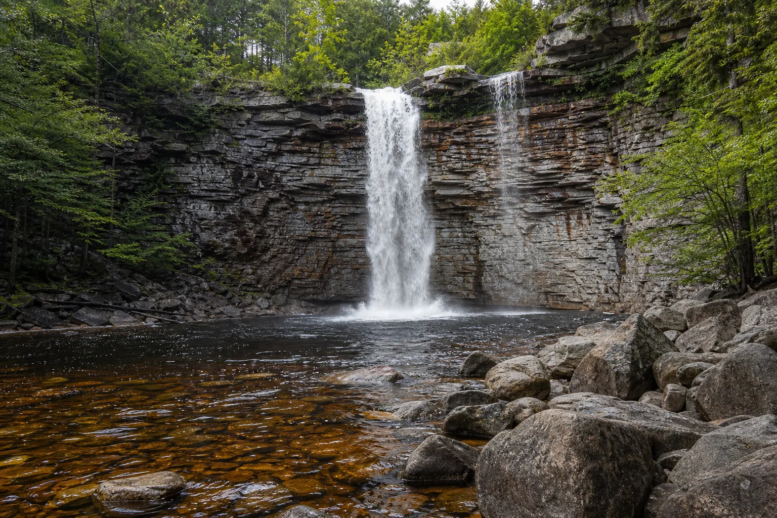
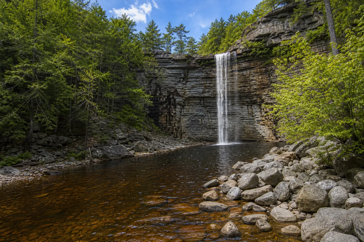
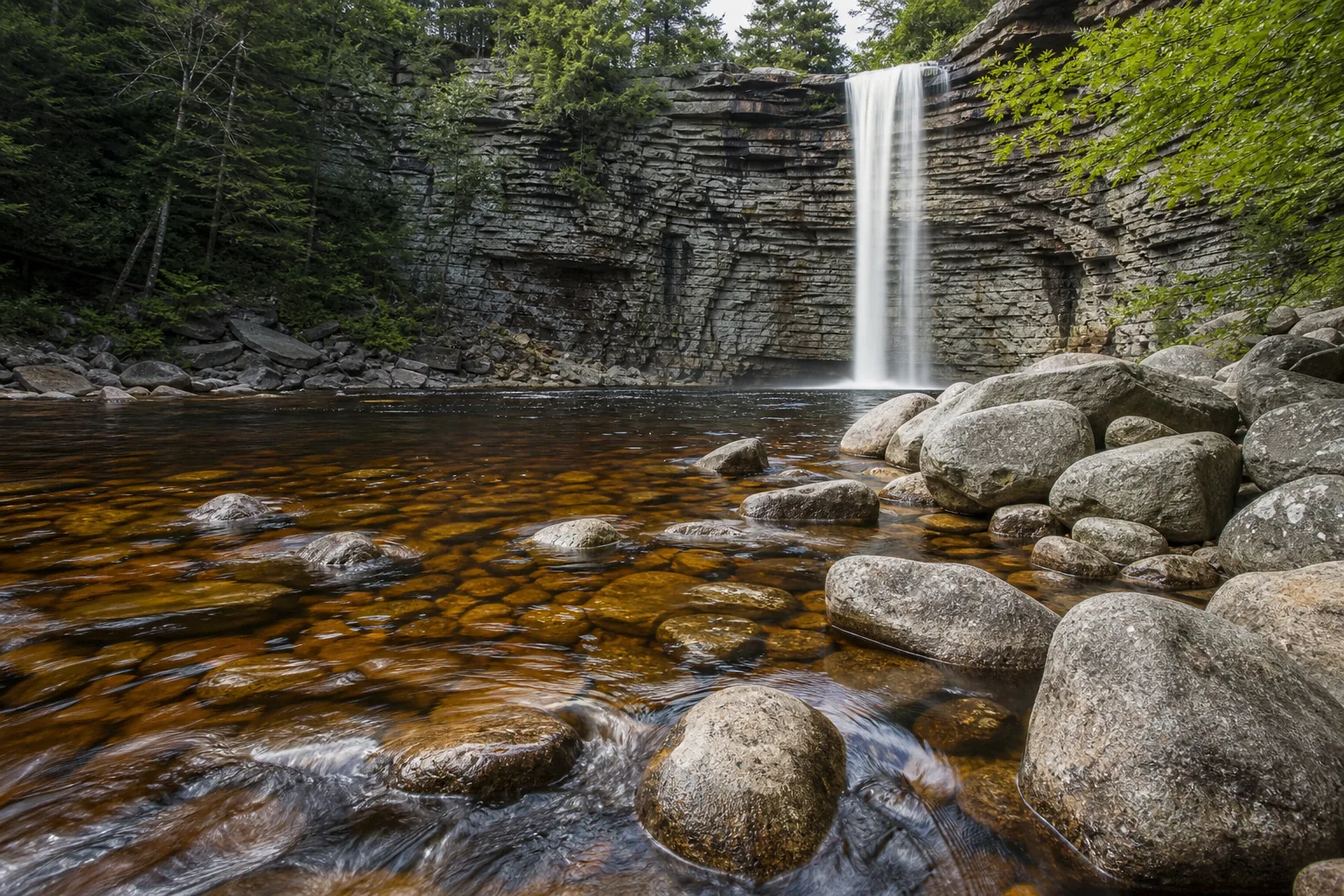
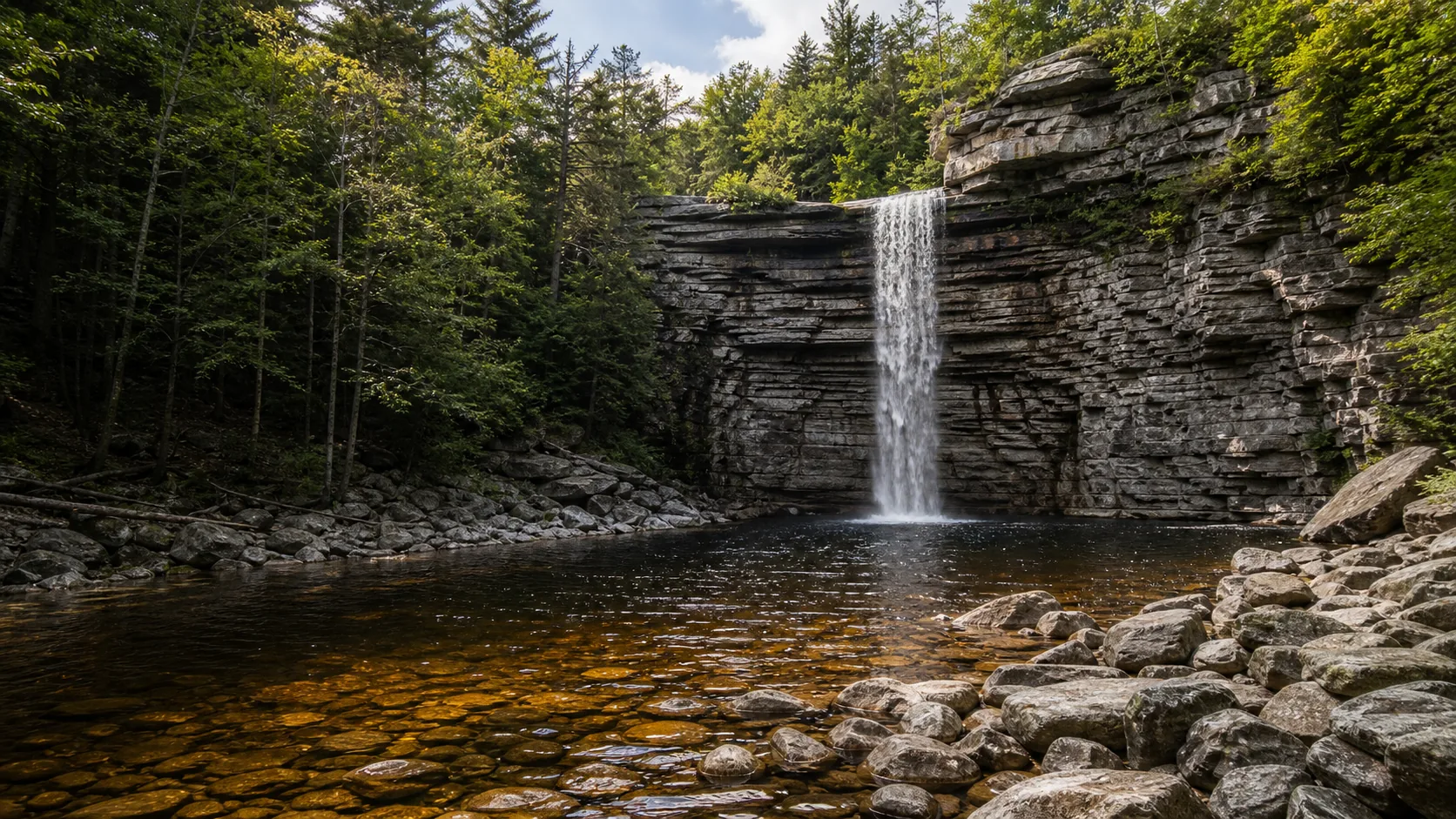
The two best windows are mid-April through mid-May for snowmelt and spring rain, when the falls runs as a thick curtain off the cliff, and the second and third weeks of October when the Shawangunk hardwoods peak above the cliff line. Minnewaska State Park Preserve charges $10 per vehicle at the Route 44/55 gatehouse (Empire Pass accepted), opens at 9 a.m. daily, and is day-use only. Swimming in the falls is prohibited; the lifeguarded beach is on Lake Minnewaska a half mile away.

  • 60-ft plunge over Shawangunk Conglomerate
  • 0.5 mi flat walk from Awosting Falls lot
  • $10/vehicle entrance, opens 9 a.m.
  • Peak flow: April-May; foliage: mid-Oct
  • No swimming at the falls; beach on Lake Minnewaska
  • Empire Pass accepted at the gatehouse
Last verified May 12, 2026 Visited Desk-verified May 2026 8 sources checked
Distance 0.5 mi 1.1 mi extended
Round trip 20-60 min Wide carriage road; short descent from upper viewpoint to the plunge pool
Difficulty Easy Wide carriage road; short descent from upper viewpoint to the plunge pool
Location Kerhonkson, NY Minnewaska State Park Preserve
Parking $10 vehicle entrance fee at the gatehouse on Route 44/55 (Empire Pass accepted). Park the lower Awosting Falls lot for the shortest walk; main upper lot at Lake Minnewaska for the 1.1 mi connection. NY State Parks
Transit No fixed-route transit verified Drive in via Route 44/55 from New Paltz · 0 ft
Drive 11 mi 20 min from downtown
Best season Apr-May for runoff; Oct for foliage Apr-May snowmelt and rain events
Awosting Falls base of awosting falls and the dark plunge pool at the foot of the shawangunk cliff.
Photo guide

Three angles of a 60-foot plunge.

Three working viewpoints around Awosting: the upper cross-canyon frame from the carriage road, the bottom-up power shot from the plunge pool, and the side-angle read of the white-pebbled conglomerate cliff with the curtain in mid-frame. Use the captions to pick angles before you commit to the descent.

Awosting Falls 60-foot plunge over Shawangunk Conglomerate cliff into the Peters Kill canyon
Awosting Falls, hero composition
Awosting Falls wide view showing the 60-foot vertical plunge and surrounding Shawangunk cliffs
Wide view of the 60-foot Awosting Falls plunge over the Shawangunk Conglomerate cliff into the Peters Kill canyon.
Awosting Falls plunge pool and water force at the base of the cliff
Base of Awosting Falls and the dark plunge pool at the foot of the Shawangunk cliff.
Detail of Awosting Falls water and Shawangunk Conglomerate rock at the lip
Close detail of the white quartz-pebble Shawangunk Conglomerate at the lip of Awosting Falls.
01Is Awosting Falls flowing right now?

This guide does not pair Awosting Falls with a verified real-time USGS discharge gauge on Peters Kill, so the live flow chip is intentionally hidden.

Peters Kill has no paired live USGS discharge gauge at the falls. As a regional proxy, the USGS Wallkill River gauge about 8 km east tracks the same storm and snowmelt events, but it overstates absolute flow at the falls. Use recent rain and snowmelt as the practical signal.

02How long is the walk?

From the lower (Awosting Falls) parking area, the trail is a 0.5-mile out-and-back on a flat carriage road with a short steep descent to the base. From the main upper Lake Minnewaska parking lot, the Awosting Falls Connection Trail adds about 0.3 miles each way for a 1.1-mile round trip.

03How do you get there?

From New Paltz, take Route 299 west to Route 44/55 and continue past the Mohonk Preserve West Trapps trailhead. The Minnewaska gatehouse is a few minutes farther; pay the $10 vehicle fee and follow signs to the lower Awosting Falls lot for the shortest walk.

04Is there free parking?

The lower Awosting Falls parking lot fills first on foliage weekends in October and on hot summer Saturdays. The main upper parking lot at Lake Minnewaska is larger; on overflow days NY State Parks turns vehicles away at the gate. Arrive at gate open (9 a.m.) on peak weekends.

05Does it cost money?

$10 vehicle entrance fee at the Route 44/55 gatehouse. Empire Pass holders enter free. No additional fee for the falls or the trail. Mohonk Preserve passes do not cover entry to Minnewaska State Park Preserve.

06Trail variants

Awosting Falls direct 0.5 mi out-and-back, 20-30 min, from the lower (Awosting Falls) parking area off Route 44/55.
Lake Minnewaska to Awosting Falls 1.1 mi round trip, 45-60 min, Awosting Falls Connection Trail from the main upper parking lot.
Falls plus Peters Kill loop 2.5 mi, 75-90 min, carriage-road circuit returning along the kill.
Via Trapps Trail (long approach) 7.7 mi, 3-3.5 hr, from the West Trapps trailhead on Route 44/55; bypasses entrance fee.

Detailed maps and recent reviews: Falls route on AllTrails · Creek route on AllTrails

07Can you swim?

Swimming is prohibited at Awosting Falls and in the plunge pool. The legal swim area in the Preserve is the designated Lake Minnewaska beach when lifeguards are on duty (typically late June through Labor Day).

08Are dogs allowed?

Dogs are allowed on a 6-foot leash on the carriage road to Awosting Falls and on most Preserve trails. Dogs are not allowed on the Lake Minnewaska swimming beach. Bring water; the carriage road has no shade in midsummer.

09Is it accessible?

The upper carriage-road viewpoint of the falls is reachable on a hard-packed, mostly level gravel surface. The descent to the plunge pool is steep, rocky in places, and is not wheelchair accessible. Restrooms are at the upper Lake Minnewaska parking area.

Field notes

Awosting at a glance.

60-foot single-tier plunge over Shawangunk Conglomerate; Peters Kill; Minnewaska State Park Preserve, 24,272 acres; $10 vehicle entrance fee; 9 a.m. open; day use. Sourced from NY State Parks and the NY State Geological Survey.

Height 60 ft USGS 3DEP
Type Plunge (single tier) USGS
County Ulster Kerhonkson, NY
Managed by New York State Office of Parks, Recreation and Historic Preservation NY State Parks
Water source Peters Kill USGS
Elevation 1427 ft USGS NED
Park area 24,272 acres NY State Parks
Hours Park opens 9am daily; closing varies by season (typically dusk) NY State Parks
When to visit

Two windows that justify the trip.

Mid-April through mid-May for snowmelt-fueled high flow off the conglomerate cliff. The second and third weeks of October for peak Shawangunk hardwood color above the cliff line. Summer is a quick stop on the way to the Lake Minnewaska beach; January and February occasionally produce a partial ice column in cold years.

PEAK FLOW

Peak flowApr-May snowmelt and rain events
Ice / low flowJan-Feb ice column in cold years
Most crowdedWeekends and midday
Best photosSunrise or weekdays

Live water context

Discharge data -- This guide does not pair Awosting Falls with a verified real-time USGS discharge gauge on Peters Kill, so the live flow chip is intentionally hidden.

Why is it called Awosting Falls?

The name Awosting is a probable Anglicization of a Munsee-Lenape root often rendered as wasing or awasin, meaning roughly place at the top or at the high place. It is applied first to the ridge-crest lake about three miles to the southwest of the falls and then to the falls and to the creek that drains the lake. Lake Minnewaska, by contrast, is a 19th-century coinage in the Dakota language imported by the resort builders; the two names sit side by side on a Shawangunk ridge that was Munsee-Lenape country long before either word reached the trail signs.

What else to do at Minnewaska State Park Preserve

Minnewaska State Park Preserve is a 24,000-acre preserve on the Shawangunk Ridge above the Wallkill Valley, with the falls in its northern lobe, Lake Minnewaska in the middle, and Lake Awosting and Lake Maratanza spread along the high ridge to the south. New Paltz is the nearest town and the practical base for food, lodging, and a stop at the Mohonk Preserve trailheads on the way in. Verify gate hours, current trail status, and any seasonal closures on the New York State Parks Minnewaska page before driving.

  • 60-foot single-tier plunge over Shawangunk Conglomerate into a small canyon on Peters Kill. The lip is sharp-edged because the rock is so resistant to weathering.
  • 0.5-mile out-and-back from the lower lot on a flat, family-friendly carriage road, with a short steeper descent to reach the base of the falls.
  • Sky-lake setting. Lake Minnewaska sits a half-mile from the falls at about 1,650 ft; Lake Awosting sits three miles south at the ridge crest.
  • Shawangunk climbing context. The cliff at the falls is the same conglomerate that builds the Trapps, Near Trapps, and Millbrook Mountain crags used by climbers across the Mohonk Preserve and the Preserve.
  • $10 vehicle entrance fee at the Route 44/55 gatehouse; Empire Pass accepted; day-use only; gates open at 9 a.m.

Why it looks this way

Awosting Falls drops over the Shawangunk Conglomerate, a tough Silurian-age rock of rounded white quartz pebbles cemented in a hard quartz-sandstone matrix. The same formation builds the cliff line that runs the length of the ridge and gives the Gunks their reputation as one of the best traditional rock-climbing areas in the eastern United States. The lip of the falls is sharp-edged rather than rounded because the conglomerate is so resistant to weathering that the creek cannot smooth the contact; instead, joints in the rock control where slabs break off, which is why the wall behind the curtain is vertical rather than concave. The Shawangunk Ridge is essentially a tilted slab of this conglomerate raised during the Acadian orogeny and exposed by 400 million years of erosion of the softer Martinsburg shale beneath it.

Field guide deep dive

What the Minnewaska page does not tell you about Awosting.

Shawangunk Conglomerate, the four ridge-top sky lakes, the Mohonk Preserve vs Minnewaska SPP distinction, swimming rules, and a half-day plan that pairs the falls with Lake Minnewaska. Skim the headers; read what you need.

How Awosting Falls formed: Silurian quartz pebbles and a refusal to weather

Awosting Falls drops over a single sheer wall of the Shawangunk Conglomerate, a Silurian-age rock laid down roughly 420 million years ago in coastal-plain river systems that drained the rising Taconic mountains. The rock is the signature lithology of the Shawangunk Ridge: rounded white quartz pebbles, some up to a few centimeters across, cemented in a hard quartz-sandstone matrix. The pebbles are themselves the durable survivors of an earlier round of mountain-building, which is why the conglomerate is so resistant to chemical and physical weathering.

That resistance is the reason the lip of Awosting Falls is sharp-edged rather than smoothed and rounded. Most waterfalls in the eastern United States flow over softer sedimentary rock; the creek polishes the lip, the falls retreats slowly and evenly, and the rock behind the curtain takes on a concave bowl shape. At Awosting, the creek cannot wear the conglomerate down at a meaningful rate. Instead, joints in the rock control how slabs break off the wall, and the cliff behind the curtain is essentially vertical. Look at the falls in profile and the geometry is a clean rectangle, not a half-bowl.

The Shawangunk Conglomerate is the same rock that builds the cliff line running the length of the ridge: the Trapps, the Near Trapps, Millbrook Mountain, and the cliffs at Sam's Point. That continuous wall is the reason the Gunks are one of the best traditional rock-climbing destinations in the eastern United States, and it is the reason the ridge above the falls reads as a stripe of pale rock visible from the Wallkill Valley below.

The 0.5-mile walk: carriage roads, an upper viewpoint, and a steep descent

Two practical options for reaching Awosting Falls, both family-friendly. The short version starts at the lower Awosting Falls parking lot just past the Route 44/55 gatehouse. From the lot, a flat, hard-packed carriage road runs about a quarter mile to the upper viewpoint of the falls. This is the wide cross-canyon frame, reachable on a wheelchair- and stroller-passable surface. A short steep descent on a rocky footpath drops to the base of the cliff and the plunge pool, which is the bottom-up power shot.

The longer version, the Awosting Falls Connection Trail, starts at the main upper Lake Minnewaska parking area and runs about 0.55 miles down a carriage road to the falls. It is the natural route if you are pairing the falls with the lake, the swimming beach, or the carriage-road loop around the upper rim. The carriage roads in the Preserve are old resort-era graded surfaces, level and wide, intended for horse-drawn traffic; they remain the easiest walking infrastructure in the Shawangunks.

For experienced hikers who want to skip the entrance fee, the long approach from the Mohonk Preserve West Trapps trailhead on Route 44/55 is 7.7 miles round trip, with a 561-foot elevation gain. That route is moderate, takes 3 to 3.5 hours, and crosses Mohonk Preserve land (which has its own day-use fee or member access) before entering the State Park Preserve.

The Shawangunk sky lakes: Minnewaska, Awosting, Maratanza, Mohonk

One of the rarer features of the Shawangunk Ridge is the cluster of four sky lakes: ridge-top, oligotrophic, clear-water lakes that sit in basins on the conglomerate above 1,500 feet. From north to south they are Mohonk Lake (on Mohonk Preserve land at the historic Mountain House), Lake Minnewaska (in the Preserve, near the upper parking lot and the swimming beach), Lake Awosting (in the Preserve, about three miles southwest of the falls), and Lake Maratanza (in the Preserve, at Sam's Point at the southern end of the ridge). Awosting Falls drains the Lake Awosting basin via Peters Kill.

These lakes are oligotrophic because the conglomerate basin offers almost no soluble minerals, so the water carries very little dissolved nutrient load. The result is extreme clarity and a thin, acid-tolerant aquatic community. Lake Minnewaska is the only one of the four with a designated public swimming beach, and the beach is staffed by lifeguards on a posted summer schedule. The other three lakes are visit-and-look destinations rather than swim destinations, with Lake Awosting reachable by an 8- to 10-mile round-trip carriage-road walk from the upper lot.

Swimming reality: no at the falls, yes at the lake

Swimming is prohibited at Awosting Falls and in the plunge pool. The pool is deeper than the broad, shallow plunge pools at most regional waterfalls, and the surrounding canyon walls funnel cold water and currents that are hazardous even when the surface looks calm. NY State Parks enforces the rule; rangers post the closure and patrol the lot on warm weekends.

The legal swim option in the Preserve is the designated Lake Minnewaska beach, about a half mile from the falls on a flat carriage road. Lifeguards are on duty on a posted schedule, typically late June through Labor Day weekend. The beach is small, the water is cold (it sits at 1,650 feet of elevation), and the bottom shelves quickly. On hot July and August weekends the parking lot fills before mid-morning and NY State Parks turns vehicles away at the gate. If you want a guaranteed swim, plan to arrive at gate open (9 a.m.) and budget time for the falls separately.

Mohonk Preserve vs Minnewaska State Park Preserve: same ridge, different gates

One of the most common visitor confusions on the Shawangunk Ridge is the distinction between the Mohonk Preserve and the Minnewaska State Park Preserve. They share a ridge, share the same Shawangunk Conglomerate, and share carriage-road infrastructure built during the 19th-century resort era. They do not share an entrance fee, a management agency, or a membership.

The Mohonk Preserve is a private nonprofit conservation organization that owns about 8,000 acres on the northern ridge, including the Trapps and Near Trapps climbing cliffs and the West Trapps trailhead on Route 44/55. Day-use access to the Mohonk Preserve is by their own ticket or membership; their pass does not cover the State Park Preserve. Minnewaska State Park Preserve is a 24,272-acre state-run preserve to the south and west, managed by the New York State Office of Parks, Recreation and Historic Preservation. It contains Awosting Falls, Lake Minnewaska, Lake Awosting, and Sam's Point. The State Park Preserve charges $10 per vehicle at the Route 44/55 gatehouse and accepts the Empire Pass.

Both organizations work in partnership on land protection and trail maintenance, and the carriage-road network connects across boundaries; you can walk from Mohonk Preserve land into Preserve land on the same trail. But you need the matching pass for whichever gate or lot you parked at. The Open Space Institute and the Friends of the Shawangunks have spent decades helping assemble both holdings into the contiguous protected ridge that exists today.

When to come and what it costs

Two windows justify a special trip. Mid-April through mid-May for snowmelt and spring rain off the ridge: in a normal year the falls runs as a thick continuous curtain off the cliff for two to four weeks, and the carriage road is still quiet before Memorial Day weekend. The second and third weeks of October for peak Shawangunk hardwood color above the cliff line; expect parking-lot overflow on those Saturdays and arrive at gate open (9 a.m.) or use the longer Connection Trail from the upper Lake Minnewaska lot. Summer is a quick stop on the way to the Lake Minnewaska beach; January and February occasionally produce a partial ice column in cold years, though the descent to the plunge pool is icy and microspikes are recommended.

Costs are straightforward. The Minnewaska gatehouse on Route 44/55 charges $10 per vehicle for day use, with the New York State Empire Pass accepted. There is no separate fee for the falls or the trail. Gates open at 9 a.m. daily and close at posted times that vary by season (typically near dusk). The Preserve is day-use only; there is no camping inside the boundary, and the closest reliable lodging and food are in New Paltz, about 11 miles east on Route 44/55.

Map and route

Twenty minutes from New Paltz on Route 44/55.

From New Paltz, take Route 299 west to Route 44/55 and continue past the Mohonk Preserve West Trapps trailhead. The Minnewaska gatehouse is a few minutes farther; pay the $10 vehicle fee and follow signs to the lower Awosting Falls lot for the shortest walk.

Photography and weddings

South-southwest-facing curtain, three working positions, drones prohibited.

Three working positions. The upper viewpoint on the carriage road is the wide cross-canyon frame and the only step-free option. The base of the falls (reached by a short steep descent on the south side) is the bottom-up power shot with the plunge pool in foreground. The side-angle frame from the southeast gives the cleanest read of the conglomerate cliff with the curtain in mid-frame.

The falls faces roughly south-southwest, so direct sun on the curtain is harsh from mid-morning through early afternoon in summer. Soft overcast, the first hour after gate opening, or the last 90 minutes before park closing all work better. Mid-October backlights the foliage above the cliff line at the end of the day.

Personal photography from the public viewpoints does not require a permit. Drone use is prohibited in the Preserve without a NY State Parks special-use permit, and commercial filming and large portrait sessions require advance approval.

Permits

Weddings and engagements

Small portrait sessions at the upper Awosting Falls viewpoint are feasible mid-week and in shoulder season; the cliff line and conglomerate texture are the differentiated frame the Catskills side cannot match.

NY State Parks charges a special-event use fee starting around $150 for small ceremonies and reserves popular Preserve locations. Confirm current rates and applications with the Minnewaska office before scheduling.

Plan for the $10 vehicle entrance fee for every car in the wedding party, the 9 a.m. open, and the limited parking at the lower Awosting Falls lot. A weekday or shoulder-season visit avoids the foliage-weekend overflow turning cars away at the gate.

Related questions

More questions visitors ask before driving to Awosting Falls.

Hike length, hours, fees, dogs, swimming, opening time, accessibility, and the actual answer to the worth-visiting question. The full set is also indexed in the FAQ schema for AI answer engines.

01Where is Awosting Falls?

Awosting Falls is in the northern lobe of Minnewaska State Park Preserve in Ulster County, New York, on Peters Kill. The gatehouse is at 5281 Route 44/55, Kerhonkson, NY 12446, about 11 miles west of New Paltz on Route 44/55.

02How tall is Awosting Falls?

Awosting Falls is approximately 60 feet tall in a single vertical drop. It plunges off a sheer wall of Shawangunk Conglomerate into a small canyon on Peters Kill. Some local references list 65 feet; NY State Parks signage commonly cites 60 feet.

03What time does Minnewaska State Park open?

The Minnewaska State Park Preserve gates open at 9 a.m. daily and close at posted times that vary by season (typically near dusk). The Preserve is day-use only; there is no camping inside the boundary. On peak foliage weekends, vehicles are turned away at the gate once parking lots fill.

04Is Awosting Falls worth visiting?

Yes, especially in mid-April through mid-May for spring runoff off the conglomerate cliff and in the second and third weeks of October for foliage above the ridge. The 60-foot single-tier plunge over Shawangunk Conglomerate is one of the most accessible major waterfalls in the Hudson Valley, reachable on a flat 0.5-mile carriage-road walk that families can do without difficulty.

Sources and data

Where the Awosting guide gets its facts.

NY State Parks Minnewaska State Park Preserve page for fees, hours, and rules. NY State Geological Survey and USGS for the Shawangunk Conglomerate geology. Open Space Institute and Friends of the Shawangunks for Preserve history. AllTrails for current trail conditions on the 0.5-mile direct route.

NY State Parks: Minnewaska State Park Preserve parks.ny.gov
Access, parking, and permit rules: parks.ny.gov
New York State Geological Survey / USGS: Shawangunk Conglomerate (Silurian): Kerhonkson bedrock usgs.gov
NOAA / NWS Albany forecast grid ALY/62,19 noaa.gov
USGS National Elevation Dataset 3DEP
Wikidata: Q4830143 (Awosting Falls) wikidata.org
Google Maps: embedded map and directions maps.google.com
Google Places: nearby restaurants and hotels places API
New York State Parks: Minnewaska State Park Preserve parks.ny.gov
Wikipedia: Awosting Falls en.wikipedia.org
Wikidata: Awosting Falls wikidata.org
AllTrails: Lake Minnewaska to Awosting Falls Connection Trail alltrails.com
Friends of the Shawangunks (land protection history) shawangunks.org
Open Space Institute (Preserve assembly and acquisitions) openspaceinstitute.org
Wikimedia Commons - Awosting Falls images commons.wikimedia.org
Fact checks
Fee audit: $10 per vehicle day-use entrance fee at the Route 44/55 gatehouse is the current published rate on the NY State Parks Minnewaska State Park Preserve page; Empire Pass accepted.
Height audit: Awosting Falls is cited as 60 feet by NY State Parks signage and Wikipedia; some local references (Ulster County Tourism, AllTrails comments) list 65 feet. The guide uses 60 feet as the conservative, agency-cited value.
Hours audit: 9 a.m. opening is the standard summer/shoulder season open published by NY State Parks; closing time varies seasonally and is typically near dusk. Day-use only.
Geology audit: Shawangunk Conglomerate is Silurian in age, quartz-pebble lithology with a quartz-sandstone matrix, ridge-forming on the Shawangunk Ridge; description cross-checked against NY State Geological Survey and USGS published literature.
Corrections: [email protected]