Spencer, Tennessee
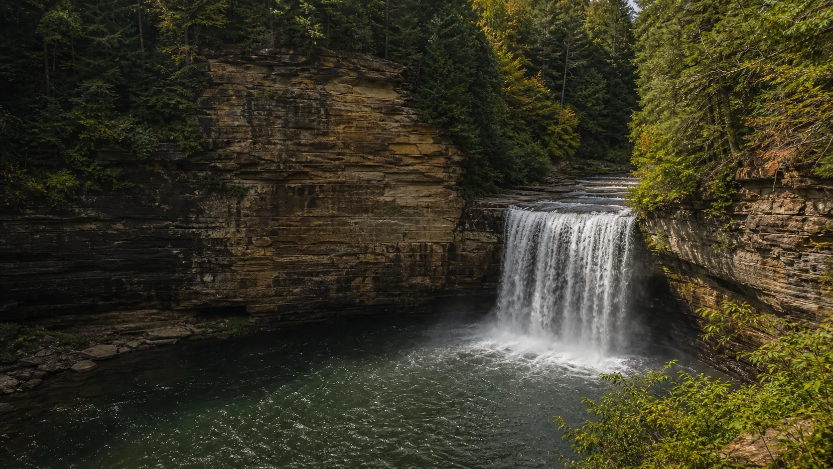
Cane Creek Falls
Plan Cane Creek Falls near Spencer, Tennessee: 0.4 mi route details, parking and directions, best time to visit, safety notes, and 4 waterfall photos.
85 ft0.4 mi4 photos
Tennessee's waterfall identity lives on the Cumberland Plateau. Sandstone caprock over softer rock produces the plateau-edge plunges from Fall Creek Falls south to Foster Falls. Two of those falls are published in full here; both involve real safety or permit considerations that visitors should read before driving.
Tennessee is one of the densest waterfall states in the eastern United States and almost all of its headline drops sit in the same place: the rim of the Cumberland Plateau. A flat highland of Pennsylvanian sandstone runs from Kentucky south through Middle Tennessee into Alabama, and hundreds of streams cut narrow gorges off that rim as the cap retreats. Every famous Tennessee waterfall (Fall Creek Falls at 256 ft, Burgess Falls, Rock Island, Ozone Falls, Foster Falls, and dozens of smaller ledges) is some version of the same caprock-undercut mechanic.
Waterfalls Guide currently publishes two Tennessee falls in full, both on the plateau, both worth reading before you drive. Cane Creek Falls is an 85-foot plunge inside Fall Creek Falls State Park near Spencer, the largest by volume of the five named waterfalls inside the park. It is the closest fall to the Nature Center and is one of the easiest 85-foot plunges in the state to read from above. It is also the site of repeated drownings at the base pool; swimming is prohibited, and the strenuous Cable Trail to the base is for the view, not the swim. Cummins Falls sits about 90 minutes north near Cookeville, a 75-foot multi-tier drop on the Blackburn Fork. The basin below it is one of the most photographed swimming holes in the Southeast, but the gorge is permit-only and the gorge has closed on short notice ever since a June 2017 flash flood killed two visitors and prompted the current access system.
The honest framing for Tennessee waterfalls is that the geology is generous, the scenery is exceptional, and the safety variables are higher than at most state-park drops in other parts of the country. Plateau creeks are flashy, plunge pools are deceptive, and permit rules and weather closures are real. Below: quick picks, when to go, how the published falls cluster by region, what we have not yet published, and the questions most visitors ask before they head up TN-111 or US-70N.
85-foot Cumberland Plateau caprock plunge a short paved walk from the Fall Creek Falls Nature Center near Spencer. Free park entry, free parking, stroller-friendly overlook, and the obvious pairing with the 256-foot Fall Creek Falls on the same state-park loop.
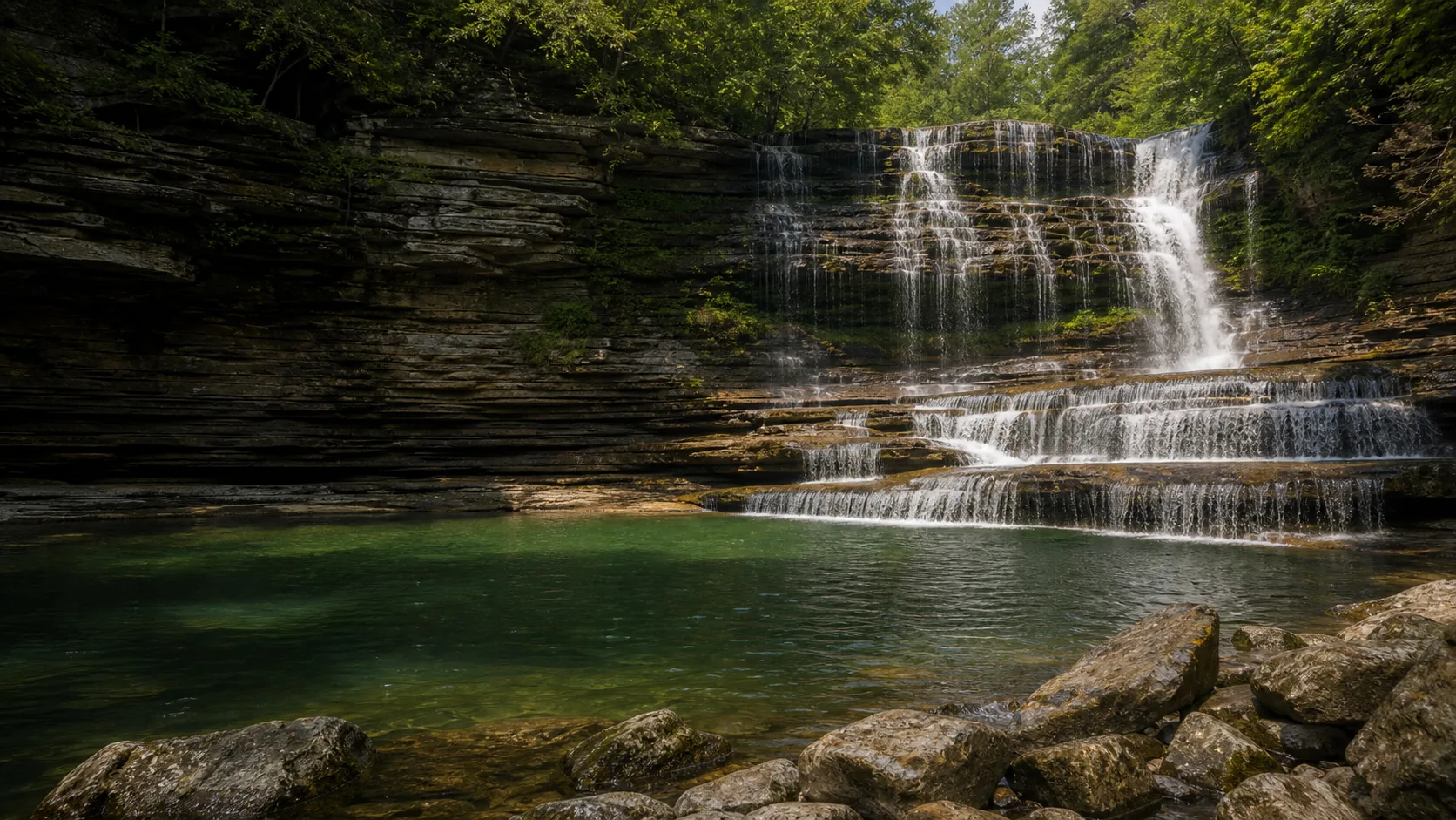
75-foot multi-tier on Blackburn Fork near Cookeville with one of the best basin swims in the Southeast. Free 0.5-mile overlook trail, but the gorge requires a $6 timed Gorge Access Permit booked through reserve.tnstateparks.com and closes during flash-flood weather.
March through May is the loudest window across the Cumberland Plateau. Spring rain and runoff push Cane Creek above the lip in a full curtain, and the same storms make Cummins Falls thunderous from the overlook. The catch at Cummins is that those same storms trigger gorge closures, so the loudest viewing days from the rim are often days you cannot enter the basin. The Cable Trail to the base of Cane Creek Falls is also closed when the rock is wet, which happens often in spring.
June through early September is the practical swim window at Cummins, when the Blackburn Fork basin sits in the mid-70s Fahrenheit and the gorge stays open through the drier stretches. Permit slots for summer weekends sell out a week or more in advance. The first two weeks of October are the photographer window plateau-wide: fall color in the gorges, manageable flow, fewer crowds. Winter is quieter and seldom deeply frozen on the plateau, but the Cable Trail at Cane Creek closes whenever ice forms on the rock or the fixed cable, and the Cummins gorge is intermittent at best.
Fall Creek Falls is the largest state park in Tennessee at over 26,000 acres and holds five named waterfalls. Cane Creek Falls is the one published here; the other four (Cane Creek Cascade at 45 ft, Rockhouse Falls at 85 ft, Piney Falls at 95 ft, and Fall Creek Falls itself at 256 ft) are not yet published as full guides but are reachable on the same park visit. Most visitors center the day on the Nature Center: paved overlook to Cane Creek Falls, suspension bridge over the gorge, then drive south to the Fall Creek Falls overlook. Half a day covers four of the five. The park is free to enter.
Cummins Falls anchors the cluster around Cookeville, where Blackburn Fork, the Falling Water River, and Cane Creek all cut narrow plateau gorges within 30 minutes of town. The published guide here is Cummins Falls. Burgess Falls State Park is the obvious companion stop, a four-cascade sequence on the Falling Water River about 30 minutes south, and Window Cliffs State Natural Area is the third leg with creek-crossing wading pools on a 5-mile loop. None of these are publicly published as full Waterfalls Guide articles yet other than Cummins; we point to Tennessee State Parks for the rest.
Tennessee has hundreds of named waterfalls. The densest cluster sits along the rim of the Cumberland Plateau in Middle Tennessee, where Pennsylvanian sandstone caprock over softer Mississippian limestone and Pennington shale produces plateau-edge plunges by the dozen. Famous examples include Fall Creek Falls (256 ft), Burgess Falls, Rock Island, Ozone Falls, and Foster Falls. The Great Smoky Mountains and the Cherokee National Forest add a second cluster on the Tennessee-North Carolina border. Waterfalls Guide currently publishes two full Tennessee guides (Cane Creek Falls and Cummins Falls); for the rest, Tennessee State Parks and the National Park Service remain the best references.
The tallest waterfall in Tennessee is Fall Creek Falls, a 256-foot plunge inside Fall Creek Falls State Park near Spencer. It is one of the tallest waterfalls east of the Mississippi. Fall Creek Falls sits in the same state park as Cane Creek Falls (the published 85-foot plunge near the park Nature Center), and most visitors see both on the same trip. Waterfalls Guide does not yet publish a full Fall Creek Falls guide; the Tennessee State Parks Fall Creek Falls page is the current reference.
Because of the geology. The Cumberland Plateau is a broad highland armored by a hard cap of Pennsylvanian sandstone sitting on softer Pennington Formation shale and Mississippian-age limestone underneath. Plateau streams run on top of the sandstone until they reach the rim, then leave the cap and drop into the softer rock below. The creek erodes the soft layer faster than the cap; the sandstone overhangs, eventually a slab fails, and the lip retreats upstream. Repeat that mechanic on hundreds of plateau-edge streams over millions of years and you get the gorges and waterfalls that define Middle Tennessee. It is the same caprock-undercut process at Cane Creek Falls, Cummins Falls, Fall Creek Falls, Burgess Falls, and Foster Falls.
Most Tennessee waterfalls do not require a permit. Fall Creek Falls State Park, including the overlook to Cane Creek Falls, is free to enter with no reservation needed. The notable exception is Cummins Falls: the park itself and the half-mile Falls Overlook Trail are free, but entering the Blackburn Fork gorge or the basin at the base of the falls requires a timed Gorge Access Permit booked online through reserve.tnstateparks.com. Permits cost $6 per adult and $3 per child age 5 to 12; children under 5 are not permitted in the gorge at all. Summer weekend permits typically sell out a week or more ahead.
It depends on the fall, and the honest answer at the most famous ones is no. Cane Creek Falls in Fall Creek Falls State Park does not allow swimming at the base or in Cane Creek Cascade upstream; the plunge pool has produced fatal drownings and rangers have repeatedly flagged deceptive currents and recirculating hydraulics. Cummins Falls does allow swimming in the basin at the base of the lower 25-foot cascade, but only with a valid Gorge Access Permit, and the gorge closes during flash-flood weather. The Fall Creek Lake swim area inside Fall Creek Falls State Park is the designated park swim spot if you want to swim near Cane Creek Falls.
On June 11, 2017, a fast-moving thunderstorm dropped heavy rain on the Blackburn Fork watershed upstream of Cummins Falls. Water in the narrow gorge rose several feet in minutes. Two visitors (a 27-year-old woman and a 2-year-old child) were swept downstream and killed, multiple others were injured, and roughly 100 people had to be evacuated. The event drove the current Gorge Access Permit system that Tennessee State Parks introduced in 2019. The permit caps the number of people in the gorge at any time, funds staffed water-level monitoring, and gives rangers a roster they can recall if conditions change. The gorge now closes any time the National Weather Service issues a flash-flood watch or warning for the upper Blackburn Fork, when staff-monitored water levels exceed a posted threshold, or when forecast rain upstream is heavy enough that a safe exit cannot be guaranteed.
Most of the Cumberland Plateau waterfall cluster sits within a 90-minute to two-hour drive east of Nashville. Cummins Falls is the closest published guide, about 80 miles east near Cookeville. Cane Creek Falls in Fall Creek Falls State Park is about two hours east via I-24 and TN-111. Falls not yet published as full guides but easily reached from Nashville include Burgess Falls (about 90 minutes east on the Falling Water River), Rock Island State Park's Great Falls (90 minutes southeast on the Caney Fork), and Fall Creek Falls itself in the same park as Cane Creek Falls.
March through May for the loudest spring flow across the Cumberland Plateau, and the first two weeks of October for fall color with manageable flow. June through early September is the practical swim window if you have a permit for the Cummins Falls basin. Winter is quieter and seldom deeply frozen on the plateau, but the Cable Trail to the base of Cane Creek Falls closes whenever ice forms on the rock or the fixed cable, and the Cummins gorge is intermittent in winter. Spring is the most weather-dependent: the same storms that produce peak flow also trigger gorge closures at Cummins and trail closures at Cane Creek.
Plan Cane Creek Falls near Spencer, Tennessee: 0.4 mi route details, parking and directions, best time to visit, safety notes, and 4 waterfall photos.
Plan Cummins Falls in Jackson County, Tennessee: 1.5 mi route details, parking and directions, best time to visit, safety notes, and 8 waterfall photos.