Routt County, Colorado
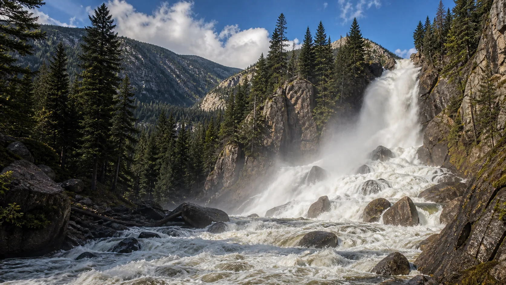
Fish Creek Falls
Plan Fish Creek Falls in Routt County, Colorado: 0.5 mi route details, parking and directions, best time to visit, safety notes, and 8 waterfall photos.
280 ft0.5 mi8 photos
Practical guides to two Colorado waterfalls, from a 280-foot Park Range plunge above Steamboat Springs to a 30-foot slot-canyon wade next to Great Sand Dunes. Verified parking fees, trail lengths, seasonal access, and live USGS data against USFS, BLM, and USGS sources.
Colorado is one of the strongest waterfall states in the American West, but its falls are scattered rather than clustered: a 300-mile Sangre de Cristo spine, the Park Range and Mount Zirkel highlands above Steamboat Springs, the San Juan volcanic field around Telluride and Ouray, the western slope canyons cut by the Colorado and Yampa rivers, and the front-range foothills west of Denver each carry their own waterfall geology. The headline names you may already know (Bridal Veil in Telluride, Hanging Lake in Glenwood Canyon, Seven Falls in Colorado Springs, Rifle Falls in Garfield County, Treasure Falls on the Wolf Creek corridor) sit in five different ranges with five different rocks. We have not yet published in-house guides to those falls, and rather than fake breadth we point you at the two we have verified end-to-end.
The two Colorado falls covered on Waterfalls Guide today sit at opposite extremes of the state and of the visitor experience. Fish Creek Falls is a 280-foot two-tier plunge on the western flank of the Park Range, four miles east of downtown Steamboat Springs, with a $5 USFS day-use site, a paved 0.25-mile boardwalk to the lower overlook, and a live USGS discharge gauge that has been running since 1996. Zapata Falls is a 30-foot waterfall hidden inside a slot canyon at the western edge of the Sangre de Cristo Range, five miles south of Great Sand Dunes National Park, reachable only by wading up South Zapata Creek through the slot itself. Both drop across Precambrian gneiss and schist, the same billion-year-old metamorphic basement that forms the spine of the Colorado Rockies, and both freeze into ice-climbing destinations in January and February.
This hub indexes the two Colorado waterfall guides published on Waterfalls Guide so far. They cover two regions (Park Range / Routt National Forest and Sangre de Cristo / San Luis Valley) and pair cleanly with very different itineraries: ski-town day trip in northwest Colorado versus dunes-plus-slot-canyon in the south. Each guide carries practical access detail (trail length, parking fees, road conditions, dog rules, winter access) verified against U.S. Forest Service, Bureau of Land Management, USGS, and Colorado Geological Survey sources.
A 280-foot two-tier plunge over Park Range gneiss reached by a paved 0.25-mile boardwalk, four miles east of downtown Steamboat Springs with a live USGS gauge since 1996 and a $5 USFS day-use fee.
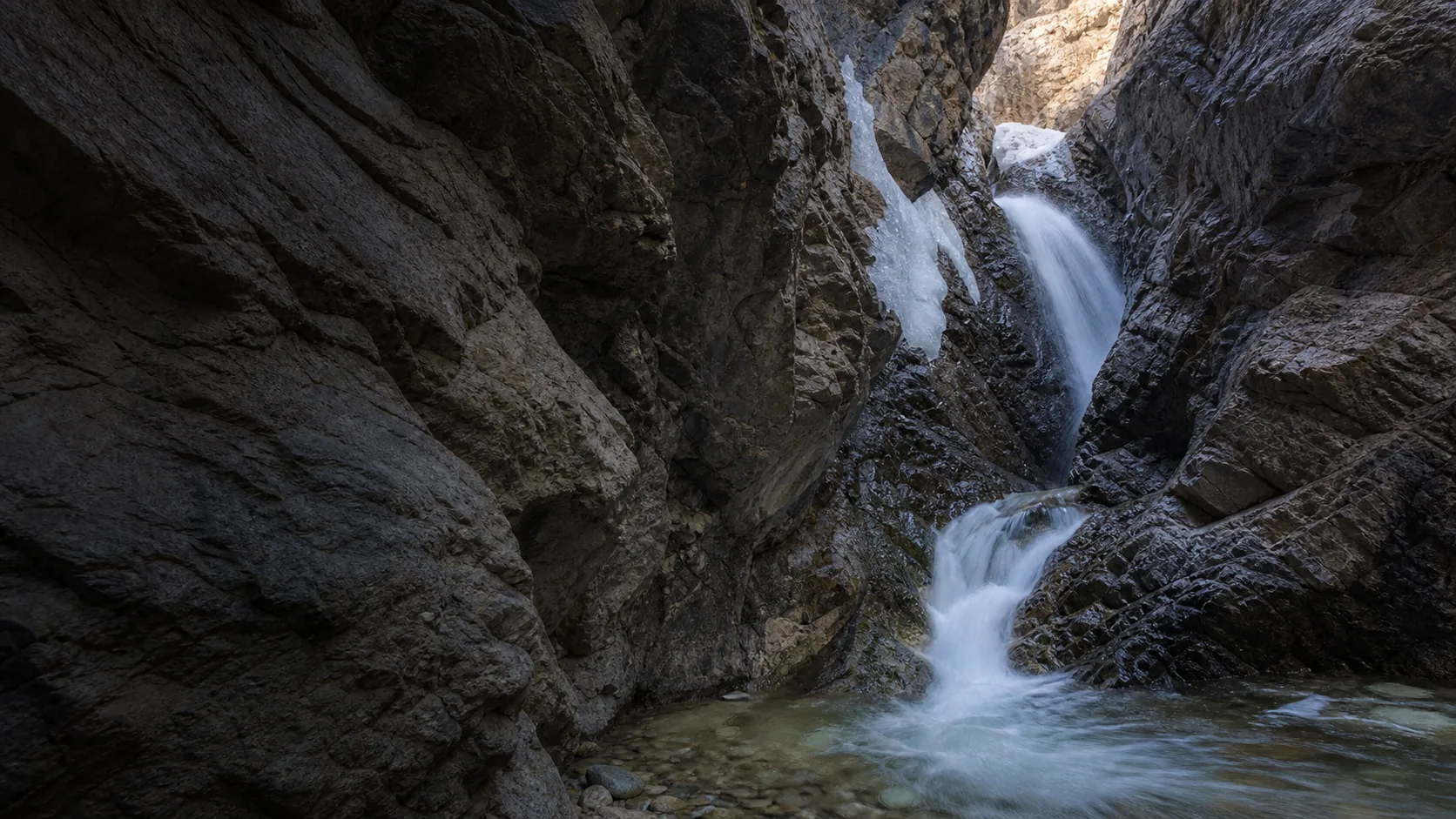
A 30-foot waterfall hidden inside a slot canyon at the western edge of the Sangre de Cristo Range, reached by wading South Zapata Creek with the Great Sand Dunes framed five miles to the north.
Colorado waterfalls run on a snowmelt-and-monsoon clock. Peak flow at both Fish Creek and Zapata lands in late May through June, when Park Range and Sangre de Cristo snowpack drives the strongest discharge of the year; Fish Creek's USGS gauge typically clears its 75th percentile (34 cfs) for most of June and can run above 200 cfs in heavy snowmelt years. A second pulse arrives with the July through August monsoon, when afternoon thunderstorms push short, sharp flow spikes through both drainages. By September flows thin but visibility is excellent for the underlying rock structure.
The second trip-justifying window is late December through February, when both falls freeze into ice features. Fish Creek's 280-foot face partially or fully encases in ice and supports a small local ice-climbing season; Zapata's slot freezes into a vertical blue ice cone (typically WI3) that is one of the best winter photo subjects in southern Colorado. Two access constraints to plan around: Fish Creek's lot is plowed but the boardwalk past the overlook usually requires microspikes or snowshoes, and Zapata's 3.6-mile gravel access road is not plowed at all, so deep snow can require 4WD.
The Park Range runs north from Rabbit Ears Pass into the Mount Zirkel Wilderness east of Steamboat Springs, with Precambrian gneiss and schist basement carved by Pleistocene alpine glaciation. Fish Creek Falls is the most accessible big waterfall in northwest Colorado; Upper Fish Creek Falls (4 mi round trip) and Long Lake (8 mi into the Mount Zirkel Wilderness) extend the same trail register for prepared hikers.
The Sangre de Cristo Range forms a long, narrow north-south spine of Precambrian gneiss and schist that runs from central Colorado toward Santa Fe, with the San Luis Valley floor (the northern Rio Grande rift basin) immediately west. Zapata Falls sits on BLM land five miles south of Great Sand Dunes National Park; the two sites pair as a one-day southern Colorado classic, with dunes in the morning and the slot-canyon wade in the warmer afternoon.
Colorado has several hundred named waterfalls scattered across the Sangre de Cristo, Park Range, San Juan, Sawatch, Front Range, and Elk Mountain ranges, plus dozens more in the canyons cut by the Colorado, Yampa, and Animas rivers. The state has no single dense waterfall corridor comparable to the Columbia River Gorge in Oregon; instead the falls are distributed widely, which is why most Colorado waterfall trips are road trips rather than single-trailhead visits. Waterfalls Guide currently publishes two verified Colorado guides (Fish Creek and Zapata) and is expanding coverage as additional falls are field-checked.
Bridal Veil Falls outside Telluride is widely cited as the tallest free-flowing waterfall in Colorado at 365 feet, dropping over Precambrian-and-Paleozoic bedrock with a small historic hydroelectric plant perched at the lip. Waterfalls Guide has not yet published a verified guide to Bridal Veil. Of the falls we do cover, Fish Creek Falls near Steamboat Springs is the tallest at 280 feet across two tiers, and is one of the tallest accessible (paved boardwalk to a lower overlook) waterfalls in northwest Colorado.
Two windows. Late May through June is peak snowmelt across the Park Range, Sangre de Cristo, and most of the high country, when discharge runs at or above the 75th percentile and the largest falls become continuous roaring curtains. Late December through February is the ice-cover window, when many high-elevation Colorado falls freeze into mixed ice and free-flowing water, with the most reliable ice through January and the first half of February in normal cold winters. July through September works for clean lower flow with monsoon spikes after thunderstorms, and late September adds aspen color in the Park Range and southern San Juans.
Most charge a modest day-use fee rather than a true entry fee. The two falls covered on this hub both charge $5 per vehicle: Fish Creek Falls is a USDA Forest Service day-use site in Routt National Forest, and Zapata Falls is a Bureau of Land Management Special Recreation Management Area. A federal interagency pass (America the Beautiful, Senior, Access, Military, 4th Grade) covers both. Outside this hub, falls inside Colorado State Parks units typically require a state park pass, and falls inside national parks (Crater Lake-style situations like Hanging Lake's permit system in Glenwood Canyon) carry separate access requirements you should verify directly with the managing agency.
Not at either of the falls covered on this hub. Fish Creek Falls runs cold and fast through a boulder field with strong hydraulic recirculation at the lower bowl during snowmelt; swimming is not advised. Zapata Falls is a wading destination rather than a swimming one, with very cold snowmelt water and slick rock inside the slot. For Colorado waterfall-adjacent swimming the standard alternatives are warm-water sites (Strawberry Park Hot Springs near Steamboat Springs, the indoor Old Town Hot Springs) and seasonal natural creek wades like Medano Creek at the base of the Great Sand Dunes.
Yes, several front-range falls sit within 60 to 90 minutes of Denver, including Helen Hunt Falls and Seven Falls in Colorado Springs, Boulder Falls on Boulder Creek, and falls inside Roxborough State Park and Roosevelt National Forest. Waterfalls Guide has not yet published verified guides to the Denver-area falls; the two Colorado guides we currently cover sit further from Denver (Fish Creek Falls is roughly 3 hours northwest near Steamboat Springs; Zapata Falls is roughly 4 hours south near the Great Sand Dunes).
Zapata Falls is the closest, sitting on BLM land about five miles south of the Great Sand Dunes National Park entrance off CO-150. The two sites pair naturally as a single-day southern Colorado trip: dunes in the cool early morning, lunch in Alamosa, then the slot-canyon wade at Zapata Falls in the warmer afternoon. The Zapata trailhead overlook also gives one of the best free views of the dune field and the western Sangre de Cristos. No other named major waterfalls sit within short driving distance of the park.
Plan Fish Creek Falls in Routt County, Colorado: 0.5 mi route details, parking and directions, best time to visit, safety notes, and 8 waterfall photos.
Plan Zapata Falls in Alamosa County, Colorado: 0.8 mi route details, parking and directions, best time to visit, safety notes, and 8 waterfall photos.