Teton County, Wyoming
Moose Falls
Plan Moose Falls in Teton County, Wyoming: 0.1 mi route details, parking and directions, best time to visit, safety notes, and 8 waterfall photos.
30 ft0.1 mi8 photos
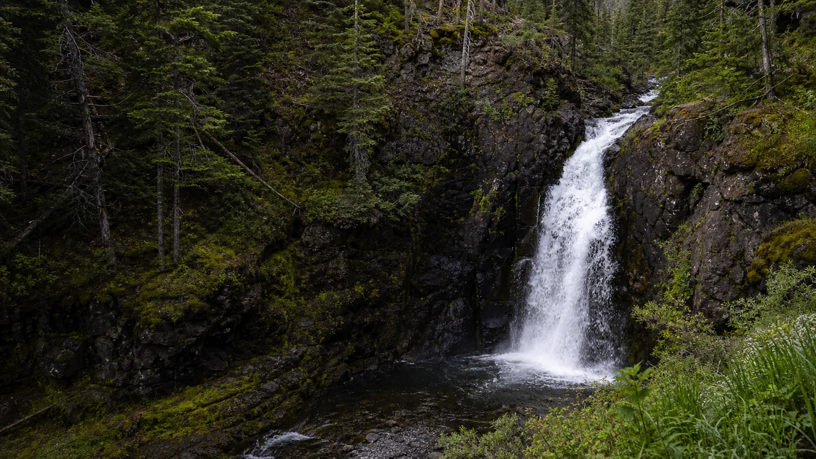
Wyoming's waterfall story is mostly Yellowstone. Moose Falls is the easiest roadside drop in the park, 30 feet of Crawfish Creek over 631,000-year-old Lava Creek Tuff just inside the South Entrance, accessible late May through early November on the $35 park pass.
Wyoming is a waterfall state in the way that Yellowstone is a waterfall state. The 2.2-million-acre national park in the northwest corner holds the densest concentration of named drops anywhere in the Rocky Mountain interior, and the rest of the state's waterfalls sit at varying distances from that center of gravity. The Lower Falls of the Yellowstone in the Grand Canyon section is the headliner at 308 feet, twice the height of Niagara, with the Upper Falls (109 feet) right above it. Tower Falls (132 feet), Gibbon Falls, Firehole Falls, Lewis Falls, Cave Falls (the widest waterfall in the park), Crystal Falls, and Mystic Falls fill out the published Yellowstone roster, and a long tail of smaller named drops sits on tributary creeks from one corner of the park to the other.
Outside Yellowstone the state still delivers, just at a quieter scale. Grand Teton National Park, 10 miles south through the John D. Rockefeller, Jr. Memorial Parkway, has its own short list, most famously Hidden Falls in Cascade Canyon (reached by the Jenny Lake shuttle or a longer rim walk) and the seasonal cascades hanging off Garnett Canyon and the south fork of Cascade Canyon. The Bighorn National Forest on the east side of the state holds Shell Falls, a roadside cascade on US-14 between Greybull and Burgess Junction. The Wind River Range and the Sinks Canyon State Park area near Lander contain Popo Agie Falls and the Sinks themselves, where the Middle Fork of the Popo Agie River disappears into a limestone cavern and resurfaces a quarter-mile downstream.
The one Wyoming waterfall we have walked end to end and published in full is the lowest-friction roadside drop in Yellowstone: Moose Falls, a 30-foot plunge on Crawfish Creek about 1.2 miles north of the park's South Entrance station. The cascade goes over a welded ledge of Lava Creek Tuff, the rhyolitic ash-flow sheet erupted from the Yellowstone Caldera about 631,000 years ago that caps much of the southern plateau. The walk from the unsigned pullout to the brink is roughly 100 feet, the full visit runs 10 to 15 minutes, and the falls pairs naturally with Lewis Falls 7.6 miles up the same road.
This hub indexes the Wyoming waterfall guide published on Waterfalls Guide so far. It covers one region (Yellowstone's South Entrance corridor) and treats the rest of the state's waterfall universe honestly: the National Park Service Yellowstone and Grand Teton pages, the US Forest Service Bighorn and Shoshone National Forest pages, and the Wyoming State Parks pages for Sinks Canyon remain the canonical references until the rest of those guides are written. The operational details matter here in a way they do not at most state waterfalls, because Yellowstone's South Entrance Road closes to wheeled vehicles from early November through mid-May, and the falls is technically reachable in deep winter only by guided snowcoach or snowmobile.
Late May through June is the snowmelt window. Crawfish Creek and the rest of the South Entrance corridor run their hardest and brownest of the year as the Yellowstone Plateau sheds its winter snowpack. The South Entrance Road typically opens to wheeled vehicles on the second Friday in May (plowing dependent), so the earliest visits are in the first or second week of the open season. Bears are coming out of dens and the meadows along Crawfish Creek and the Lewis River are some of the most reliable wildlife viewing in the park; carry bear spray.
July and August are the easiest visit weather and the most crowded month in Yellowstone overall, though Moose Falls itself stays surprisingly quiet because the pullout is unsigned and most drivers do not slow down on the climb up from the South Entrance. Crawfish Creek runs steady through the heat of summer, the lip thins from the spring runoff curtain to a cleaner single channel, and the lodgepole forest is in full green. Arrive at the South Entrance station before 9 a.m. to skip the long entry queues that build through July and August, especially on weekends.
Late September through early October is the under-rated visit. The lodgepole stays green but scattered aspen along Crawfish Creek and through the South Entrance corridor turns yellow, the elk rut is in full swing in the meadows along the Lewis River, and the crowds drop sharply after Labor Day. The South Entrance Road generally stays open to wheeled vehicles through the first Sunday in November, and the cleanest fall-color window is the last week of September and the first week of October. Bring layers; overnight lows at the 7,000-foot elevation of the falls already drop below freezing.
November through mid-May is the off-season. The South Entrance Road closes to wheeled vehicles in early November and reopens in mid-May, and during that window the falls is accessible only by guided oversnow coach or snowmobile from Flagg Ranch or West Yellowstone. Crawfish Creek does not freeze solid; it runs through ice fringes on either bank in deep winter because of upstream thermal seeps, which is also why the plunge pool tends to look mistier than the air temperature alone would suggest. Wait for May if a guided oversnow visit is not on your list anyway.
The only currently published Wyoming fall on Waterfalls Guide sits inside the South Entrance corridor of Yellowstone National Park, the 22-mile stretch of US-89/191/287 that climbs north from the park boundary toward West Thumb on Yellowstone Lake. Moose Falls is the first waterfall on that drive, 1.2 miles inside the gate; Lewis Falls (another 30-foot drop on the Lewis River) sits 7.6 miles north on the same road, with the Lewis Lake overlook and the Lewis River Canyon in between. The same Yellowstone entry pass covers the rest of the park's published falls, including the Lower Falls of the Yellowstone (308 ft) and the Upper Falls (109 ft) in the Grand Canyon section, Tower Falls (132 ft) on the northeast loop, and the smaller named drops at Gibbon, Firehole, Cave, Crystal, and Mystic Falls. None of those have published Waterfalls Guide pages yet; treat this cluster as the South Entrance corridor with Moose Falls as the anchor visit and the NPS Yellowstone falls pages as the canonical reference for the rest.
Wyoming has hundreds of named waterfalls, concentrated overwhelmingly in Yellowstone National Park and to a lesser extent in Grand Teton National Park, the Bighorn National Forest, and the Wind River Range. Yellowstone alone holds the Lower Falls of the Yellowstone (308 ft), the Upper Falls (109 ft), Tower Falls (132 ft), Gibbon Falls, Firehole Falls, Lewis Falls, Cave Falls, Crystal Falls, Mystic Falls, Moose Falls, and a long tail of smaller drops on tributary creeks. Grand Teton adds Hidden Falls in Cascade Canyon and seasonal cascades in Garnett Canyon. Shell Falls in the Bighorns and Popo Agie Falls near Lander round out the most-asked-about Wyoming list. Waterfalls Guide currently publishes a full Moose Falls guide and points to the National Park Service and US Forest Service pages for the rest until those guides are written.
The Lower Falls of the Yellowstone is the tallest named waterfall in Wyoming at 308 feet, where the Yellowstone River plunges into the Grand Canyon of the Yellowstone inside Yellowstone National Park. The Upper Falls (109 ft) sits a short distance upstream, and Tower Falls on Tower Creek drops 132 feet on the northeast side of the park. Outside Yellowstone the tallest named drops are in the alpine canyons of the Tetons and the Wind River Range, but most of those are seasonal ribbons rather than year-round cascades. Waterfalls Guide does not yet publish a full Lower Falls guide; we publish Moose Falls because it is the one we have walked end to end.
Yes. Yellowstone holds the densest cluster of waterfalls in Wyoming and one of the densest in the western United States. Named drops include the Lower Falls of the Yellowstone (308 ft), the Upper Falls (109 ft), Tower Falls (132 ft), Gibbon Falls, Firehole Falls, Lewis Falls, Cave Falls (the widest in the park), Crystal Falls, Mystic Falls, and Moose Falls, plus dozens of smaller drops on tributary creeks. The geology behind most of them is the same: a hard cap of volcanic tuff or rhyolite, typically the Lava Creek Tuff from the 631,000-year-old Yellowstone Caldera eruption, sitting on softer rock that wears away faster downstream and leaves a clean vertical lip.
Yes, though Grand Teton is better known for its peaks than for its falls. The most popular waterfall in the park is Hidden Falls, a 100-foot cascade in Cascade Canyon on the west side of Jenny Lake, reached by the seasonal shuttle boat plus a short trail or by a longer walk around the lake. Garnett Canyon and the south fork of Cascade Canyon hold seasonal alpine cascades that run hard during snowmelt and thin to streaks by late summer. Grand Teton sits about 10 miles south of Yellowstone's South Entrance through the John D. Rockefeller, Jr. Memorial Parkway, which is why Moose Falls and Hidden Falls often appear on the same trip.
Yellowstone National Park charges a single park entry fee that covers all roads, overlooks, and waterfall trails inside the park, including Moose Falls, Lewis Falls, the Lower and Upper Falls of the Yellowstone, Tower Falls, Gibbon Falls, Firehole Falls, and the rest. A 7-day private-vehicle pass is $35, a motorcycle pass is $30, and an individual on foot or bicycle is $20. An annual Yellowstone pass is $70. America the Beautiful interagency passes ($80 annual, free for active military and US fourth graders, $80 lifetime senior, free access pass) are honored at all entrance stations. There is no separate parking fee at any of the in-park waterfalls.
It depends on the waterfall. Inside Yellowstone and Grand Teton National Parks, leashed dogs are permitted only within 100 feet of roads, parking areas, and campgrounds; they are prohibited on all trails, off-road, in the backcountry, and in thermal areas. That includes the short use-path from the Moose Falls pullout to the brink and base. National Forest waterfalls (Shell Falls in the Bighorns, Popo Agie Falls in the Shoshone) and state-park waterfalls (Sinks Canyon) generally allow leashed dogs on trails, with the usual leash-length and waste rules. Always confirm the current rule on the managing agency's page before planning a trip with a dog.
Late May through June is the loudest window for snowmelt-fed falls statewide, including the Yellowstone and Grand Teton drops. July and August are the easiest weather and the most crowded; entrance queues into Yellowstone build through the morning, and the South Entrance corridor is busiest from late morning through mid-afternoon. Late September and the first week of October are the under-rated visit, with scattered aspen color along Crawfish Creek and the Lewis River, the elk rut in the meadows, and sharply thinner crowds. November through mid-May is the off-season for road-accessible Yellowstone falls; the South Entrance and most of the park's interior roads are closed to wheeled vehicles, and the falls are reachable only by guided oversnow travel.
Plan Moose Falls in Teton County, Wyoming: 0.1 mi route details, parking and directions, best time to visit, safety notes, and 8 waterfall photos.