Walhalla, South Carolina
Issaqueena Falls
Plan Issaqueena Falls near Walhalla, South Carolina: 0.3 mi route details, parking and directions, best time to visit, safety notes, and 4 waterfall photos.
100 ft0.3 mi4 photos
One verified Waterfalls Guide entry inside the Cherokee Foothills Scenic Byway cluster, plus what to know about the other named SC falls (Raven Cliff, Twin, Wildcat, Lower Whitewater, King Creek) before you drive up SC-11.
Almost every South Carolina waterfall search ends in the same place on the map: the SC-11 Cherokee Foothills Scenic Byway, the 118-mile state road that runs along the base of the Blue Ridge escarpment from Gaffney west through Pickens and Oconee Counties. Roughly every named SC waterfall worth driving for sits within a few miles of that corridor or one of its spur roads. The Upcountry counties (Oconee, Pickens, Greenville) hold the cluster; the rest of the state is coastal plain and sand hills with no real waterfalls to speak of.
The geology under the cluster is the same southern Blue Ridge metamorphic terrane that produces the waterfalls of North Georgia and western North Carolina: foliated gneiss and schist, hundreds of millions of years old, folded and recrystallized deep in the crust and then slowly stripped to the surface. Streams off Sassafras Mountain (the highest point in the state at 3,553 ft), Stumphouse Mountain, and the Jocassee Gorges find resistant bands of that bedrock and step over them. The result reads as a regional house style: tall single plunges or two-step cascades over banded metamorphic rock, with rhododendron tunnels and second-growth hardwood on either side.
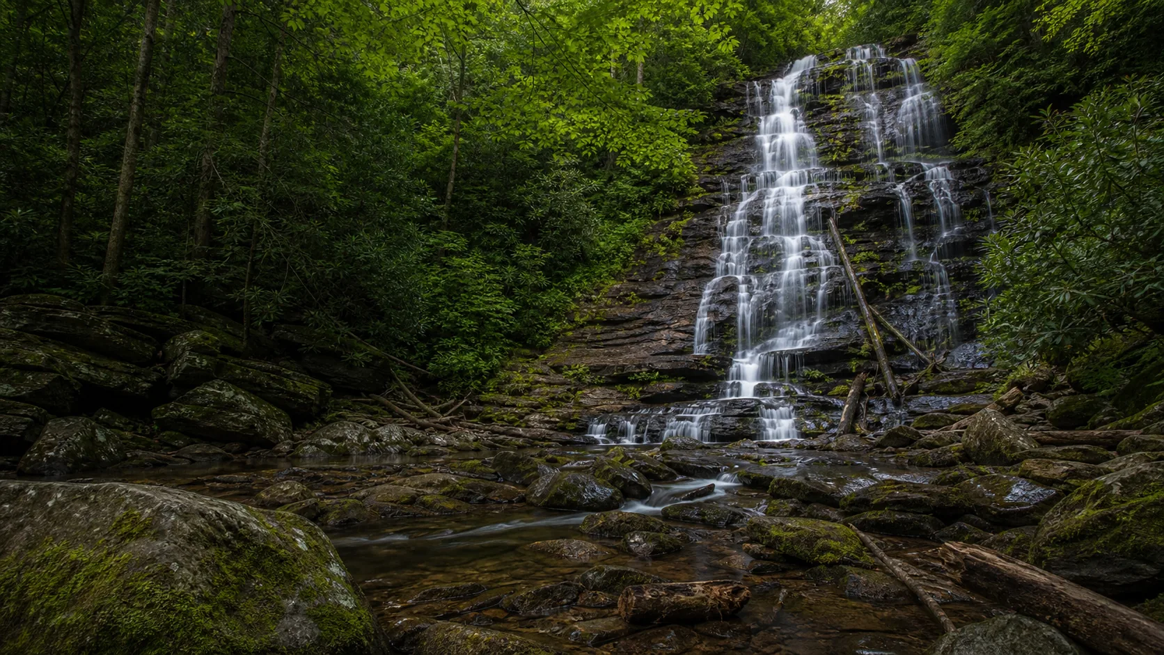
Waterfalls Guide publishes one verified South Carolina entry so far. Issaqueena Falls is a 100-foot single-drop plunge in the Sumter National Forest's Oconee Ranger District, reached by a short gravel path from the Stumphouse Tunnel parking area near Walhalla. The other named SC waterfalls (Raven Cliff, Twin Falls of Pickens, Wildcat Wayside, Lower Whitewater, King Creek) sit on the same SC-11 spine and are flagged below as planning context rather than as published guides; we will only post a verified entry once we have walked the trail end to end.
South Carolina waterfall timing has two reliable windows. The first is March through May, when Upcountry rain and the leftover winter wet load run the streams off the Blue Ridge escarpment at their loudest. Cane Creek throws a full curtain at Issaqueena, Reedy Cove Creek pushes hard at Twin Falls, and Matthews Creek doubles its volume at Raven Cliff. Spring is also the cleanest light: thin canopy, fast water, no summer haze, and the gorges are dim enough to hold detail behind the curtain.
The second peak is the second and third weeks of October for fall color. The Cherokee Foothills hardwood canopy turns red and yellow against banded gneiss and schist, and the Issaqueena overlook and the Raven Cliff platform both photograph at their best. Summer (late July and August) is the weakest reliable window for flow; the smaller streams thin to ribbons, the falls reads as a streak rather than a curtain, and the only real reason to come is for the swim pools at unrelated spots like Lake Jocassee. Winter is uncrowded and surprisingly workable. Full freezes are rare at 1,000 to 2,000 ft in Oconee and Pickens Counties; expect a working waterfall in January, not a frozen one. The trails stay open year-round at most sites and SC-11 itself does not close in normal weather. Always verify gate hours and seasonal closures at Caesars Head, Jones Gap, and the smaller state-park sites before driving; the Forest Service trailheads at Issaqueena and King Creek run on dawn-to-dusk day-use hours rather than gated entry.
The western end of the Cherokee Foothills Scenic Byway lands in Oconee County, where the Sumter National Forest's Oconee Ranger District holds the densest concentration of SC waterfalls. Issaqueena Falls and the 1850s Stumphouse Tunnel share a single parking lot off SC-28 north of Walhalla; Yellow Branch Falls (a 50-foot tiered cascade) sits two miles further up the same road and pairs naturally on the same stop. Lower Whitewater Falls (a 411-foot tiered drop on the SC side of the state line, accessed from the Bad Creek hydro project) and King Creek Falls (a 70-foot plunge in the Ellicott Rock Wilderness above the Chattooga) round out the district's published-elsewhere set. Walhalla, a German-heritage town founded in 1850, is the practical base for an Oconee day.
Raven Cliff Falls in Caesars Head State Park, on the Greenville County end of the Cherokee Foothills Scenic Byway, is the tallest waterfall in South Carolina at 420 feet. It drops in several tiers down a Blue Ridge escarpment wall on Matthews Creek and is most commonly viewed from the Raven Cliff overlook, a 4-mile out-and-back from the US-276 parking area inside the park. Lower Whitewater Falls (411 feet, on the Oconee County side of the state line below Bad Creek hydro) and Twin Falls of Pickens (about 75 feet) are the next major drops. Waterfalls Guide has not yet published a verified Raven Cliff entry; the standard reference is the SC State Parks Caesars Head page.
Dozens, almost all clustered in the three Upcountry counties (Oconee, Pickens, Greenville) along the SC-11 Cherokee Foothills Scenic Byway corridor. The South Carolina Picture Project catalogues more than 50 named waterfalls inside the state. The rest of South Carolina (Midlands, Pee Dee, Lowcountry) is coastal plain or sand hills with no real waterfalls, so any SC waterfall trip realistically means a drive into the Blue Ridge escarpment at the state's northwest corner. Waterfalls Guide publishes one verified SC entry (Issaqueena Falls) and is expanding coverage as additional falls are field-checked.
SC-11, the Cherokee Foothills Scenic Byway, is the 118-mile state-designated scenic road that runs along the base of the Blue Ridge escarpment from Gaffney in Cherokee County west through Pickens and Oconee Counties to the Lake Hartwell area. The byway is the practical organizing axis for South Carolina waterfall trips because almost every named SC fall sits within a few miles of it or one of its spurs (SC-28 for Issaqueena, US-178 for the Caesars Head area, the Bad Creek access road for Lower Whitewater). A one-day SC waterfall trip is genuinely doable along the corridor and is usually planned out of Walhalla, Pickens, or Greenville.
Most are. Issaqueena Falls, Yellow Branch Falls, and the other Sumter National Forest sites in Oconee County have free day-use parking and no entrance fee. Lower Whitewater Falls and King Creek Falls (also on USFS land) are free at the trailhead. The state-park sites are where the small fees show up: Caesars Head State Park, Jones Gap State Park, and the Mountain Bridge Wilderness charge a per-person SC State Parks day-use admission, typically a few dollars per adult with discounts for children, and an annual SC State Parks Passport is the standard option for repeat visitors. Twin Falls of Pickens sits on private land accessed through a Foothills Trail Conservancy easement and is free, with donations encouraged.
Most do not. The named SC waterfalls along the SC-11 corridor are tall single plunges or stairstep cascades over banded metamorphic rock, with shallow plunge pools, submerged rocks, and approaches that the managing agency does not maintain for swimmers. Swimming and wading at the base of Issaqueena Falls, Raven Cliff Falls, Rainbow Falls, and Lower Whitewater Falls are not recommended; there are no posted lifeguards and the splash zones are off-limits in several cases. For real swimming in the region, Lake Jocassee at Devils Fork State Park (Oconee County) is the standard option, with the Yellow Branch Picnic Area creek as a smaller cooling-off stop. The Chattooga River corridor below King Creek Falls is wadable in low-flow conditions but is a Wild and Scenic River and runs cold year-round.
The second and third weeks of October are the standard peak for the Cherokee Foothills corridor, with the highest elevations (Caesars Head, Sassafras Mountain, the Stumphouse Mountain area above Issaqueena) turning a few days earlier than the lower Pickens County terrain. Hardwood color against banded Blue Ridge gneiss is the visual headline; both the Issaqueena overlook and the Raven Cliff platform photograph at their best in that window. Arrive at trailheads before 10 a.m. on October weekends because the small lots at Issaqueena, Yellow Branch, and the Caesars Head US-276 trailhead fill quickly; weekday visits and a pre-9 a.m. start are the standard workaround.
It is folklore, not historical record. The standard telling is that Issaqueena, a young Cherokee (sometimes told as Choctaw) woman, rode through the night to warn white settlers of an impending raid, was pursued back into the mountains, and leapt from the lip of these falls to escape capture, landing on a hidden ledge and escaping the next morning. There is no contemporary 18th-century documentary source for the leap, and at least one regional account links the name instead to a real interpreter named Cataeechee whose biography was romanticized in the 19th century. The legend has cultural weight in the Upcountry and the name has spread across the region (Lake Issaqueena, Issaqueena Trail), but the documentary record does not back the story. Our Issaqueena Falls guide carries the longer write-up.
Plan Issaqueena Falls near Walhalla, South Carolina: 0.3 mi route details, parking and directions, best time to visit, safety notes, and 4 waterfall photos.