Dingmans Ferry, Pennsylvania
Dingmans Falls
Plan Dingmans Falls near Dingmans Ferry, Pennsylvania: 0.4 mi route details, parking and directions, best time to visit, safety notes, and 8 waterfall photos.
130 ft0.4 mi8 photos
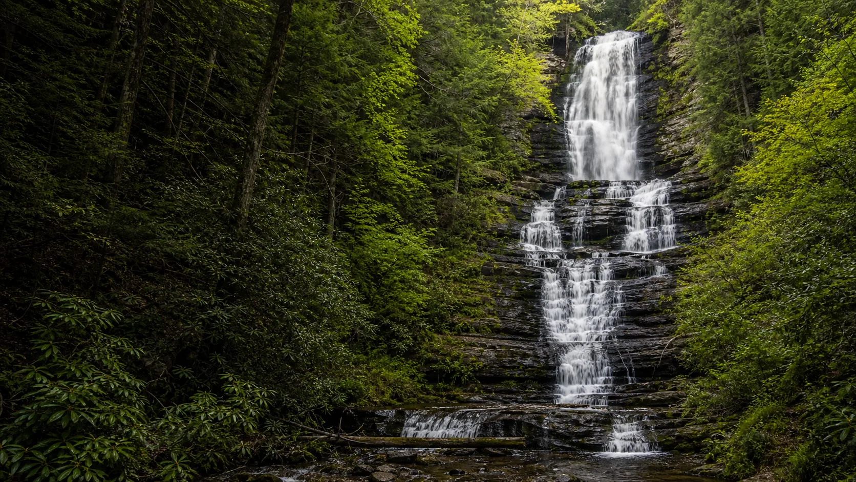
One published Pennsylvania guide so far. Dingmans Falls, a 130-foot single-tier plunge inside Delaware Water Gap National Recreation Area, reached by a fully accessible paved boardwalk. The broader Pocono and Ricketts Glen network is on the roadmap.
Pennsylvania has one of the densest waterfall networks east of the Mississippi, but the cluster is unevenly distributed. Two regions hold almost all of the named drops worth a planned trip: the Pocono Mountains and Delaware Water Gap National Recreation Area in the northeast corner of the state, and Ricketts Glen State Park in the Endless Mountains about two hours west. A handful of smaller falls (Bushkill Falls in Bushkill, Buttermilk Falls Natural Area in Indiana County, Glen Onoko outside Jim Thorpe) sit between or just outside those clusters.
Waterfalls Guide currently publishes one Pennsylvania trip in full: Dingmans Falls, a 130-foot single-tier plunge on Dingmans Creek inside Delaware Water Gap National Recreation Area. It is one of the few major eastern US waterfalls reachable on a fully accessible paved boardwalk, and the trail also passes 80-foot Silverthread Falls a few minutes from the same trailhead. The broader Pennsylvania network is not yet covered in full and is summarized below in context.
Three names matter beyond Dingmans. Raymondskill Falls, about 12 miles north of Dingmans inside the same Delaware Water Gap NRA, is the other contender for tallest in Pennsylvania at roughly 150 feet across three tiers. Ricketts Glen State Park in Luzerne County holds 24 named waterfalls on a 7.2-mile Falls Trail loop, with Ganoga Falls (94 ft) as the headline drop. Bushkill Falls is a private park rather than a public NRA site, with paid admission, a developed boardwalk system around eight named falls in the Pocono Plateau forest, and the heavy bus-tour traffic that comes with paid-attraction marketing.
The geology underneath the Pocono cluster is the Mahantango Formation, a Middle Devonian package of interbedded siltstone and shale that erodes in horizontal slabs and produces the layered, cliff-like faces visible at Dingmans, Raymondskill, and most of the Ricketts Glen falls. The deeper Marcellus Shale, the same unit that drives the regional natural-gas play, sits below it but rarely outcrops at the falls themselves. Until the rest of the Pennsylvania guides land, the NPS Delaware Water Gap NRA page and the PA DCNR Ricketts Glen page remain the standard references.
March through mid-May is the loudest window. Pocono snowmelt and spring rain push Dingmans Creek, Raymondskill Creek, and the upper Lehigh tributaries above their typical baseline, and Dingmans reads as a single full white sheet rather than a narrower veil. The same window puts Ricketts Glen at its best, with the 24-fall Falls Trail loop running every drop at high volume. Trade-offs are the usual ones: muddy approach paths, cold spray, slick wood and stone, and snow lingering on the upper Falls Trail at Ricketts Glen into early April in heavier winters.
Mid-October is the foliage window. The Pocono Plateau is one of the densest deciduous hardwood canopies on the eastern seaboard, and the gorges at Dingmans, Raymondskill, and Ricketts Glen fill with yellow, orange, and red against the gray Mahantango siltstone. Plan around the practical constraint that the Dingmans Falls Visitor Center lot fills on October weekends and the Ricketts Glen Falls Trail parking can be at capacity by 9 a.m. on Columbus Day weekend. Summer (late June through August) is the comfortable family-walk window at Dingmans on the accessible boardwalk; the falls thins to a narrower veil but remains photogenic.
Late December through February is the partial-ice window. Dingmans freezes incompletely in most winters and produces a striking ice-and-flowing-water mix on the boardwalk rather than a full ice column. The access road off Route 209 is plowed when conditions allow but is gated during the multi-year bridge replacement project on Johnny Bee Road; check NPS Delaware Water Gap NRA current alerts before driving. The Ricketts Glen Falls Trail is officially closed to all but ice climbers with full traction and gear in winter, and unauthorized winter hikes there have produced multiple serious injury reports.
Delaware Water Gap National Recreation Area is a 70,000-acre NPS unit straddling the Pennsylvania and New Jersey banks of the Delaware River, with the densest concentration of named Pennsylvania waterfalls inside it. The published Dingmans Falls guide sits on the PA side at the south end of the cluster. Twelve miles north on Route 209, Raymondskill Falls drops roughly 150 feet across three tiers and is widely cited as the tallest waterfall in Pennsylvania (the Dingmans vs Raymondskill height debate is covered in the FAQ). Bushkill Falls, a private attraction in the village of Bushkill, charges paid admission and runs its own boardwalk system around eight smaller named falls in the Pocono Plateau forest. Base towns are Stroudsburg and East Stroudsburg at the south end, Milford and Dingmans Ferry along Route 209, and Lehman at the entrance to the Pocono State Forest. The Andrew Dingman ferry crossed this stretch of the Delaware starting in 1735 and gave both the village and the falls their name.
The honest answer is that the title is disputed. Most modern sources put Raymondskill Falls inside Delaware Water Gap National Recreation Area at the top, with a quoted height of roughly 150 feet across three tiers. Dingmans Falls, also inside the NRA and about 12 miles south, is most often listed at 130 feet as a single tier. NPS signage at Raymondskill has historically called it the tallest in Pennsylvania, while several older guidebooks gave Dingmans the title. The honest read is that Raymondskill wins on total drop because it stacks three tiers, while Dingmans wins on tallest single uninterrupted plunge. Both numbers are also estimates rather than surveyed values. The Bushkill Falls private park sometimes claims its own headline drop is in the running, but the figure is not widely accepted outside the park's own marketing.
Pennsylvania has hundreds of named waterfalls, with two main concentrations. Ricketts Glen State Park alone holds 24 named falls on the Falls Trail loop. Delaware Water Gap NRA adds another dozen or so on the Pennsylvania side, including Dingmans, Raymondskill, Adams Creek Falls, Hackers Falls, and Hornbecks Creek Falls. The broader Pocono Plateau, the Endless Mountains, and the Laurel Highlands of southwestern Pennsylvania add many more. Waterfalls Guide currently publishes one Pennsylvania guide in full (Dingmans) and points to the NPS Delaware Water Gap and PA DCNR Ricketts Glen pages as standard references for the rest until those guides are published.
The densest cluster is the Route 209 corridor inside Delaware Water Gap National Recreation Area. Dingmans Falls (130 ft, fully accessible boardwalk to the base) and Raymondskill Falls (about 150 ft across three tiers) sit about 12 miles apart and are the two headline NPS-managed drops on the Pennsylvania side. Bushkill Falls in the village of Bushkill is a private park rather than an NPS site, charges paid admission, and operates its own boardwalk system around eight smaller named falls. Base towns include Stroudsburg and East Stroudsburg at the south end of the corridor, Milford and Dingmans Ferry along Route 209 itself, and Lehman near the entrance to the Pocono State Forest. The corridor is roughly two hours from New York City and 90 minutes from northern New Jersey, which is why summer and fall weekends fill the trailhead lots.
Ricketts Glen is a 13,000-acre Pennsylvania state park in Luzerne County, about two hours west of the Delaware Water Gap, with the most named waterfalls on any single trail system in the eastern United States. The 7.2-mile Falls Trail loop passes 22 named falls (24 with the off-loop additions), including 94-foot Ganoga Falls as the headline drop. Compared to Dingmans, Ricketts Glen is the volume-and-variety destination (more falls, a longer hike, more elevation, and steep stone-step descents), while Dingmans is the single-falls-with-easy-access destination (one major plunge, a fully accessible boardwalk, and a short stroll). Both share the same Mahantango siltstone and shale bedrock, which is why both produce the layered, cliff-like waterfall face common to the region. Waterfalls Guide does not yet publish a Ricketts Glen guide; the PA DCNR Ricketts Glen State Park page is the current reference.
Yes. The 0.4-mile paved boardwalk from the Dingmans Falls Visitor Center to the base of the falls is fully wheelchair and stroller accessible and is one of the very few eastern US trails to the base of a 130-foot waterfall that meets that bar. The boardwalk also passes 80-foot Silverthread Falls a few minutes in from the trailhead, also viewable from the accessible path. The optional upper observation deck at the top of Dingmans Falls is reached by roughly 240 wooden steps and is not accessible. Parking at the NPS Dingmans Falls Visitor Center lot is free, and the visitor center itself is open Memorial Day weekend through Labor Day.
The Dingmans name traces to Andrew Dingman, a Dutch settler who established a ferry across the Delaware River at this stretch in 1735. The crossing operated continuously in some form for more than two centuries and gave the village of Dingmans Ferry its name. The privately operated Dingmans Ferry Bridge, a short distance downstream of the falls, is still one of the last toll bridges on the Delaware. Dingmans Creek, the watercourse that produces Dingmans Falls, was named for the same family, and the falls themselves took the same name as nineteenth-century travelers began publishing accounts of the Pocono Plateau cascades. The land around the falls became part of Delaware Water Gap National Recreation Area when the NRA was authorized by Congress in 1965.
The Pocono and Endless Mountains waterfall cluster sits on the Mahantango Formation, a Middle Devonian package of interbedded siltstone and shale roughly 380 to 385 million years old. The formation erodes in horizontal slabs, which is why Dingmans, Raymondskill, and most of the Ricketts Glen falls share the same layered, cliff-like face. The deeper Marcellus Shale, the same unit that drives the regional natural-gas play, sits below the Mahantango but rarely outcrops at the falls themselves. Pleistocene continental ice covered the entire region until roughly 12,000 years ago and overdeepened the main valleys, leaving the smaller creeks (Dingmans Creek, Raymondskill Creek, Kitchen Creek at Ricketts Glen) as hanging tributaries that now drop off the cliff edges. The accessible Dingmans Falls boardwalk is the easiest place in Pennsylvania to read the Mahantango bedding planes at close range.
Plan Dingmans Falls near Dingmans Ferry, Pennsylvania: 0.4 mi route details, parking and directions, best time to visit, safety notes, and 8 waterfall photos.