Lincoln County, Montana
Kootenai Falls
Plan Kootenai Falls in Lincoln County, Montana: 0.9 mi route details, parking and directions, best time to visit, safety notes, and 8 waterfall photos.
90 ft0.9 mi8 photos
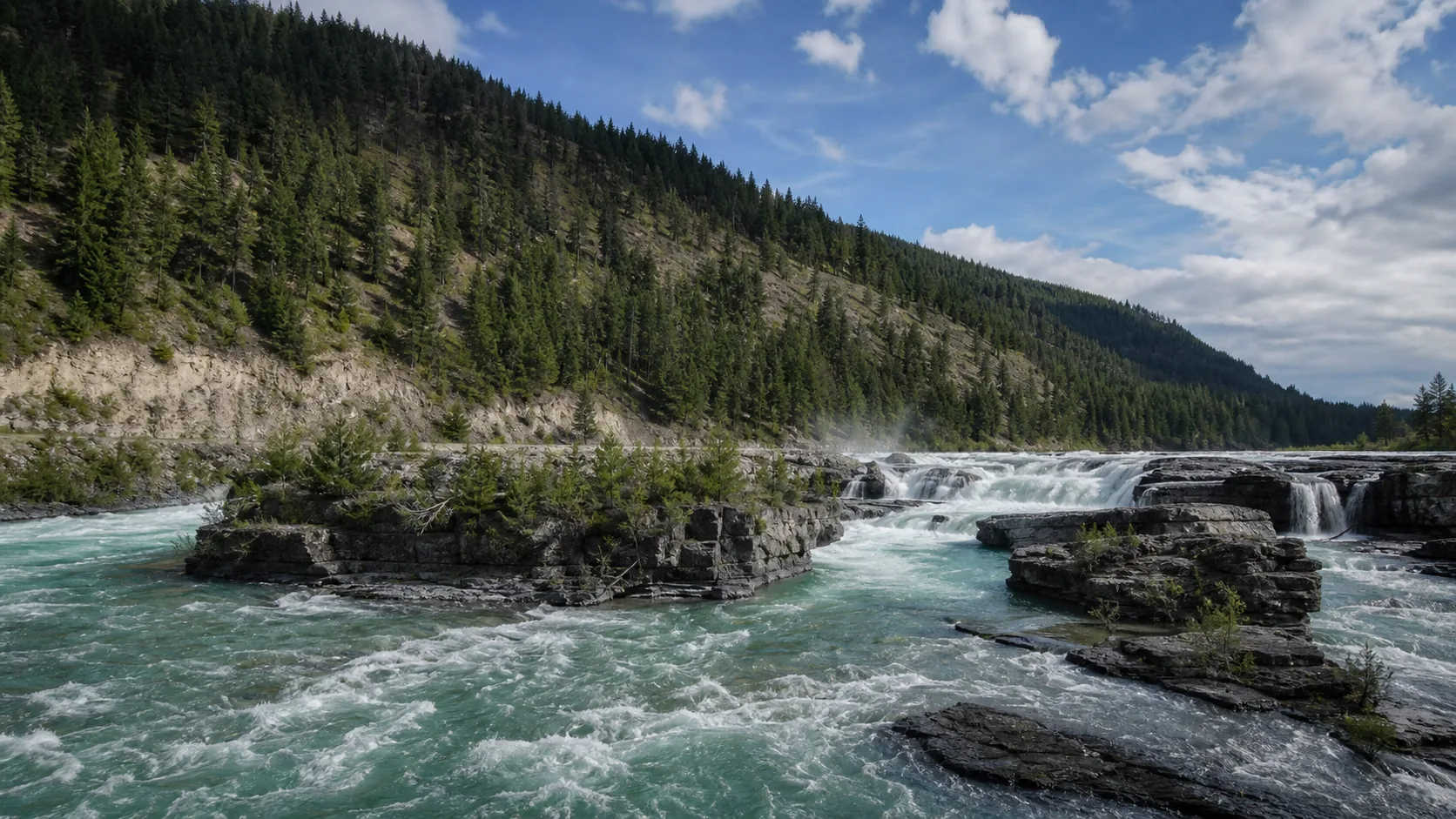
Kootenai Falls is the largest undammed waterfall in Montana, a 90-foot stair-step cascade on the Kootenai River between Libby and Troy with a public swinging suspension footbridge a short walk downstream and a film credit in The River Wild (1994).
Most people who search for Montana waterfalls have one of three pictures in their head: the spray-painted ledges of the Great Falls of the Missouri (Black Eagle, Rainbow, Crooked, and Big Falls, all four of them now partly to fully harnessed by hydroelectric dams), the alpine ribbons hanging off the Going-to-the-Sun corridor in Glacier National Park (Virginia Falls, McDonald Falls, Bird Woman Falls, Avalanche Falls), or the high-country cascades like Palisade Falls in the Gallatins and Holland Falls in the Mission Mountains. Those are real and they are on the roadmap. They are not what is currently published on Waterfalls Guide.
What is published right now is Kootenai Falls, which is also the most defensible answer to the question most people are really asking. It is the largest undammed waterfall in Montana: a 90-foot stair-step cascade where the Kootenai River drops through a tight quartzite gorge in the Cabinet Mountains of northwest Montana, eleven miles west of Libby on US Route 2. The signature visit pairs the main cascade with a public swinging suspension footbridge over a side channel just downstream, all of it reachable on a 0.6 to 1.6 mile out-and-back from a free USFS day-use lot directly off the highway.
Two things make Kootenai different from almost any other US waterfall guide on the site. First, the rock. The cascade drops over the Belt Supergroup, a 1.4 to 1.5 billion-year-old stack of quartzite and argillite that is about as old as continental crust gets in this part of the world; the river is unzipping a tilted layer cake one ledge at a time, which is why it reads as a wide staircase rather than a single plunge. Second, the cultural context. The falls is a sacred site to the Ktunaxa (Kootenai) people, whose traditional territory spans northwest Montana, the Idaho Panhandle, and southeastern British Columbia. Visitors are asked to stay on marked trails, keep their group quiet at the cascade overlook, and not leave offerings on the rocks.
The film angle is real and a draw on its own. The 1994 Curtis Hanson thriller The River Wild, with Meryl Streep and Kevin Bacon, used the China Rapids stretch immediately below Kootenai Falls as one of its on-river locations. The rapid is considered too dangerous to run commercially today, but the view from the trail above is roughly the same angle the production used for its overhead shots.
If you are headed to Glacier National Park, the Great Falls reach of the Missouri, or the Beartooth or Mission ranges, the National Park Service, US Forest Service, and Montana State Parks pages remain the best current reference for the unpublished Montana waterfalls until we get to them.
May through June is the loudest window. Cabinet Mountains snowmelt pushes the Kootenai River through Kootenai Falls at its highest and brownest reading of the year, and the cascade reads as a continuous roaring chute across all of its quartzite shelves. Late June is the sweet spot if you also want the western larch and cottonwoods to be fully green and the railroad-overpass stairs to be dry.
July and August are the easiest visit weather and the most crowded. Days are warm, the trail is dry, and the swinging bridge sees a steady summer queue at both ends on weekends. The river is lower and clearer, which exposes more of the polished quartzite shelves under the cascade; the falls is still dramatic, just visually different from the spring runoff frame. Arrive before 10 a.m. or after 4 p.m. for the easiest parking in the USFS day-use lot.
Late September through early October is the under-rated second-best visit. The western larch along the gorge walls turns gold, the river is quieter and clearer than in summer, and the lot is rarely full. The trail and swinging bridge remain open and unmaintained snow has not yet arrived.
December through February is the off-season. The trail is unmaintained in winter, the railroad-overpass stairs and the rocky descent below them ice over, and the swinging bridge can be closed for safety. The falls itself does not freeze into a column the way smaller Midwestern and Eastern falls do; ice fringes the quartzite ledges instead, and the river keeps running through the gorge. Wait for May if a Cabinet Mountains winter visit is not on your list anyway.
The only currently published Montana fall on the site sits in the 2.2 million-acre Kootenai National Forest in the far northwest corner of the state, between Libby and Troy in Lincoln County. The natural day-trip pairings from Kootenai Falls are all inside the same national forest and all free: Ross Creek Cedars (an old-growth western redcedar grove about 45 minutes south near Troy), the Cabinet Mountains Wilderness (alpine lakes and ridgelines south of Libby, about 30 minutes from the falls), the Yaak Valley (a remote scenic drive north on Highway 508), and Libby Dam at Lake Koocanusa (the upstream hydro dam that, by being upstream, defines the undammed-stretch claim at the falls itself). None of those four sites have published Waterfalls Guide pages yet; treat this cluster as the Kootenai NF corner of Montana, with Kootenai Falls as the anchor visit.
Montana has hundreds of named waterfalls, concentrated in three regions. Glacier National Park along the Going-to-the-Sun corridor holds the densest alpine cluster (Virginia Falls, McDonald Falls, Bird Woman Falls, Avalanche Falls, and many smaller ribbons). The Great Falls reach of the Missouri River holds the historic Lewis and Clark series (Black Eagle, Rainbow, Crooked, and Big Falls), most of which are now harnessed by hydroelectric dams. The Cabinet Mountains and Kootenai National Forest in northwest Montana hold a smaller but distinctive group, including Kootenai Falls, the largest undammed waterfall in the state. Waterfalls Guide currently publishes a full Kootenai Falls guide and points to the National Park Service, US Forest Service, and Montana State Parks pages for the rest until those guides are written.
By volume of free-flowing water, Kootenai Falls on the Kootenai River is the largest undammed waterfall in Montana, dropping about 90 feet total over less than a mile of river with a 30-foot main cascade. The historic Great Falls of the Missouri at Great Falls, Montana included a roughly 87-foot drop at Big Falls and a wider river at higher volume, but those falls are now partially to fully harnessed by hydroelectric dams. Glacier National Park has taller individual drops (Bird Woman Falls is roughly 492 feet), but those are thin alpine ribbons with much smaller flow.
Yes. Glacier National Park holds the densest cluster of waterfalls in Montana, most of them ribbon and cataract falls hanging off the Lewis Overthrust escarpments along the Going-to-the-Sun Road. Named drops include Virginia Falls, Bird Woman Falls, McDonald Falls, Avalanche Falls, Apikuni Falls, Running Eagle Falls, and Trick Falls. Waterfalls Guide does not yet publish full Glacier National Park guides; the National Park Service Glacier page is the canonical reference for current trail and shuttle status.
Yes. The 1994 Curtis Hanson thriller The River Wild, starring Meryl Streep and Kevin Bacon, used the Kootenai River and the China Rapids whitewater stretch immediately below Kootenai Falls as one of its filming locations. The cascade and the rapid below it are considered too dangerous to run commercially today; legal kayak access begins well downstream of the falls. The viewing angle from the trail above is roughly the same angle the production used for its overhead shots.
Kootenai Falls is a sacred site to the Ktunaxa Nation, also spelled Kutenai in some older US sources and Kootenay in Canada. The Ktunaxa are the Indigenous people whose traditional territory spans what is now northwest Montana, the Idaho Panhandle, and southeastern British Columbia, and they have lived along the Kootenai River for thousands of years. In Ktunaxa cosmology this stretch of river is described as a place where the spirit world meets the physical world. For visitors, the practical translation is to stay on marked trails rather than scrambling onto the cascades, keep groups quiet at the cascade overlook if a Ktunaxa visitor is there for ceremony, and not leave offerings or objects on the rocks.
From the free USFS day-use lot directly off US Route 2 between Libby and Troy, cross the pedestrian stair overpass above the BNSF mainline railroad, follow the trail past the main cascade overlook (the iconic 30-foot drop view), and continue downstream along the gorge. The swinging suspension footbridge is about 0.8 miles in from the lot, over a side channel of the Kootenai River. The full visit including the bridge is about 1.6 miles round trip and most visitors spend 60 to 90 minutes. There is no fee for the bridge or the trail.
May through June is the loudest window for snowmelt-fed falls across the state, including Kootenai Falls and the Glacier National Park ribbons along Going-to-the-Sun. July and August are the easiest weather and the most crowded; the Going-to-the-Sun Road requires a timed-entry vehicle reservation in this window. Late September and early October are the under-rated visit, with western larch turning gold along the Kootenai gorge and quieter trails everywhere. December through February is the off-season for most named Montana waterfalls, with trails unmaintained and the Going-to-the-Sun Road closed through the high country.
Plan Kootenai Falls in Lincoln County, Montana: 0.9 mi route details, parking and directions, best time to visit, safety notes, and 8 waterfall photos.