Township E, Maine
Smalls Falls
Plan Smalls Falls near Township E, Maine: 0.5 mi route details, parking and directions, best time to visit, safety notes, and 4 waterfall photos.
54 ft0.5 mi4 photos
Maine has a substantial waterfall network across the western mountains and the Acadian metamorphic belt. One guide is published in full: Smalls Falls, the 54-foot four-tier swimming-hole cascade on the Sandy Stream that doubles as the easiest summer pull-off on the Rangeley Lakes Scenic Byway.
Maine has more named waterfalls than most casual visitors realize. Moxie Falls outside The Forks drops about 90 feet in a single plunge and is often cited as one of the tallest single drops in New England. Angel Falls near Houghton is a 90-foot horsetail in a slot deep enough that you need to wade the stream to see it well. Step Falls in Newry stairs down a quarter mile of granite in Mahoosuc country. Houston Brook Falls near Bingham, Snow Falls on the Little Androscoggin in West Paris, and Cataract Falls in the Mahoosuc Public Lands round out the working short list. None of those have been published as verified Waterfalls Guide entries yet; the state coverage will grow as each falls is field-checked.
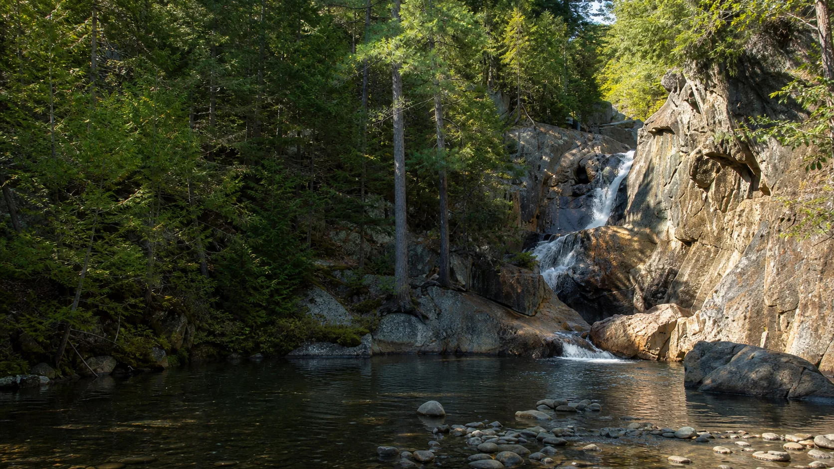
The one Maine waterfall published in full is the one that earns its 3,600-a-month search volume on its own merits. Smalls Falls is a 54-foot, four-tier cascade in a narrow bedrock gorge on the Sandy Stream, a headwater of the Sandy River, in Township E in Franklin County. It is a Maine Bureau of Parks and Lands roadside picnic area on Route 4 between Madrid and Rangeley, which means you park, walk maybe a minute, and you are already standing over the first plunge pool. It is also one of a small number of Maine waterfalls where swimming is openly welcomed by the land manager rather than tolerated, which is the real reason most visitors drive out from Portland or Lewiston on a July afternoon.
The geology under the falls is Acadian. Smalls sits in the Central Maine Belt, a Silurian-age sequence of metamorphic schist and phyllite folded and fractured during the Acadian orogeny roughly 380 to 410 million years ago and intruded by Devonian granites. Glacial sculpting during the most recent continental ice sheet, about 12,000 to 20,000 years ago, steepened the headwater slope. The Sandy Stream cut a slot into the harder rock; the four-tier geometry is what happens when a steep headwater drops through resistant bedrock with no single dominant ledge.
This hub indexes the Maine waterfall guide published on Waterfalls Guide so far. The geographic anchor is the Rangeley Lakes region and the Route 4 corridor, which is also the access route for Angel Falls, Chandler Mill Stream Falls, and Cascade Stream Gorge once those guides are field-checked and published.
Late April through May is the loud window. Snowmelt out of the Rangeley uplands pushes the Sandy River gauge well above its 30-year daily-discharge median of 31 cfs, with isolated days clearing 500 cfs in big melt years, and the four tiers run loud, cold, and continuous. The Maine BPL gate typically opens in mid-May, which means the very loudest week of the year (usually late April into the first week of May) is reachable on foot from the Route 4 shoulder but the rest area lot itself may still be closed.
July and August is the swimming window. The lower plunge pool below the bottom tier is the headline draw at Smalls Falls and reads exactly the way the brochure pictures suggest when the gauge is between 30 and 80 cfs, which is the typical mid-summer range. The lot can fill by 11 a.m. on weekends and holiday afternoons; arrive early or pair the visit with one of the longer Route 4 drives. Early October is the quieter third window for foliage running through the gorge with manageable flow before the Maine BPL gate closes for the season around mid-October. Outside that window Route 4 stays plowed but the rest area is gated, the gorge edges are ice-glazed by mid-November, and the rim path is unmaintained.
The Rangeley Lakes Scenic Byway follows Route 4 north from Phillips through Madrid and into the lakes country. Smalls Falls is the easiest waterfall stop on the corridor, set as a free Maine Bureau of Parks and Lands roadside picnic area between Madrid and Rangeley. Additional waterfalls in the same 30-minute drive (Angel Falls near Houghton, Chandler Mill Stream Falls just up Route 4, Cascade Stream Gorge near Rangeley) are part of the Maine waterfall network on the same Acadian metamorphic bedrock; full Waterfalls Guide entries for those are not yet published. Rangeley Lake State Park offers the lifeguarded lake-beach alternative if the Sandy Stream gauge is running too high for safe swimming.
Smalls Falls is run by the Maine Bureau of Parks and Lands as a roadside rest area, which is a Maine-specific model with no direct equivalent in most other states. There is no entrance booth, no day-use fee, no formal trailhead kiosk; you pull off Route 4 into a paved lot, use the vault toilets, eat at the picnic tables, and walk down to the footbridge. BPL gates the rest area in winter, which makes the practical season mid-May through mid-October. A handful of other Maine waterfalls share the same rest-area model along state highways, which is the reason a roadside-only summer day plan works in Maine in a way it does not in most New England states.
Maine has dozens of named waterfalls concentrated in the western mountains, the Rangeley Lakes region, the Mahoosuc range along the New Hampshire border, and the upper Kennebec drainage. The most often cited include Moxie Falls (about 90 ft near The Forks), Angel Falls (about 90 ft near Houghton), Smalls Falls (54 ft on Route 4 between Madrid and Rangeley), Step Falls in Newry, Houston Brook Falls near Bingham, Snow Falls in West Paris, and Cataract Falls in the Mahoosuc Public Lands. Waterfalls Guide currently publishes one verified Maine guide (Smalls Falls) and is expanding coverage as additional falls are field-checked.
The tallest single-plunge waterfall most often cited is Moxie Falls on Moxie Stream near The Forks in northern Somerset County, at about 90 feet, accessed by a short trail off Lake Moxie Road. Angel Falls near Houghton in the Rangeley region is also commonly listed at about 90 feet as a horsetail-style drop in a narrow slot. Smalls Falls, the one Waterfalls Guide publishes in full, is shorter at 54 feet but spreads its drop across four distinct tiers and is the most popular roadside waterfall in the western mountains because of its legal swimming pools.
Smalls Falls is in Township E, Franklin County, in the western Maine mountains, on the Sandy Stream just above its confluence with Chandler Mill Brook. The access point is the Smalls Falls Picnic Area, a Maine Bureau of Parks and Lands rest area pulled off Route 4 on the west side between Madrid and Rangeley. From Rangeley the rest area is about 12 miles south; from Phillips and Madrid it is about 6 miles north.
At most Maine waterfalls swimming is informally tolerated rather than openly welcomed by the land manager, and pool depths change with flow in a way that catches visitors out every summer. Smalls Falls is one of the few Maine waterfalls where the land manager openly welcomes swimming in the gorge pools, and it is the busiest waterfall swimming hole in the western mountains for that reason. Even there, the lower plunge pool has no lifeguard, water depth shifts with the USGS Sandy River gauge reading, and serious injuries have happened over the years from cliff jumps. The lifeguarded alternative in the Rangeley region is Rangeley Lake State Park.
The two strongest windows are late April through May for the loudest snowmelt flow (Sandy River gauge often running above its 75th-percentile reading of 64 cfs) and July through August for the warm-weather swimming hole at the lower plunge pool. Early October works as a quieter third window for foliage in the gorge with manageable flow before the Maine BPL gate closes around mid-October. The rest area is gated from roughly mid-October through mid-May, which lines up almost exactly with the safe swimming weather anyway.
Most named Maine waterfalls along state highways and within the Maine Bureau of Parks and Lands rest-area network are free, with no entrance fee, no day-use pass, and no parking fee. Smalls Falls is one example: free paved lot off Route 4 with picnic tables, charcoal grills, and vault toilets, all at no charge. Falls inside Maine state parks (such as Rangeley Lake State Park or Grafton Notch State Park) carry the standard state-park day-use fee. Falls on private timberland or tribal land have separate access rules that vary by site.
The waterfalls of western and central Maine sit in the Central Maine Belt, a Silurian-age sequence of metamorphic schist and phyllite that was folded, fractured, and intruded by Devonian granites during the Acadian orogeny roughly 380 to 410 million years ago. Glacial sculpting during the most recent continental ice sheet, about 12,000 to 20,000 years ago, steepened the headwater slopes and scraped the upland clean. The narrow tiered gorges typical of Maine cascades (Smalls Falls is a clean example) are slots cut into that resistant Acadian bedrock by streams following fracture zones or softer phyllite bands.
Plan Smalls Falls near Township E, Maine: 0.5 mi route details, parking and directions, best time to visit, safety notes, and 4 waterfall photos.