McCreary County, Kentucky
Yahoo Falls
Plan Yahoo Falls in McCreary County, Kentucky: 1 mi route details, parking and directions, best time to visit, safety notes, and 4 waterfall photos.
113 ft1 mi4 photos
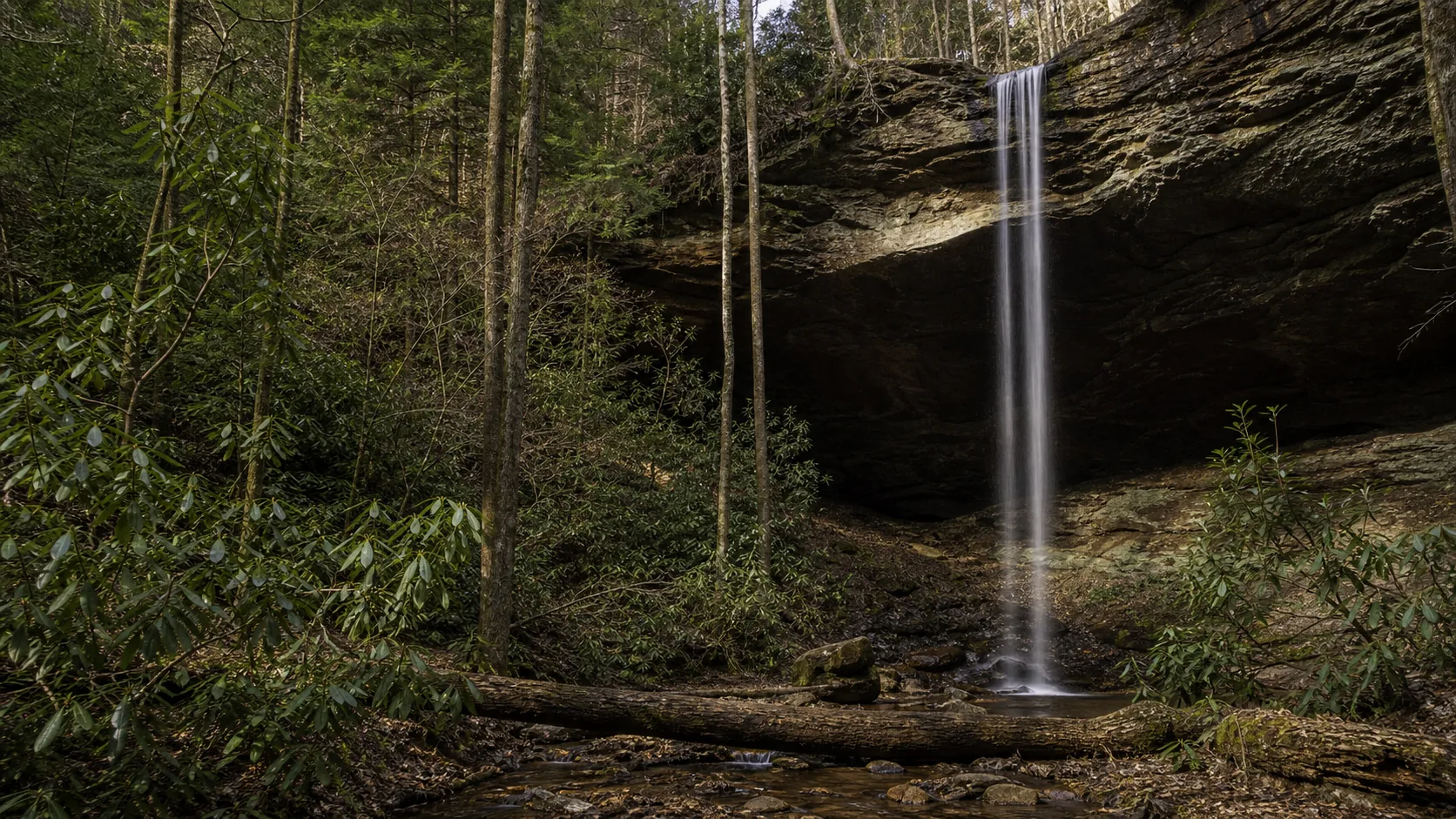
Kentucky's tallest waterfall is Yahoo Falls, a 113-foot plunge into a sandstone rock-shelter alcove in Daniel Boone National Forest. One published guide so far, plus an honest read of the larger Kentucky waterfall universe across the Cumberland Plateau.
Kentucky's waterfall map sits almost entirely on one piece of geology: the eastern rim of the Cumberland Plateau. A hard band of Pennsylvanian Lee Sandstone caps the rim across the southeastern third of the state, and creeks running off the highland find the contact with softer rock below the cap and step off the edge. The same caprock that produces the rock shelters and natural arches of the Red River Gorge and Big South Fork also produces the state's headline waterfalls, including the tallest one.
That tallest one is Yahoo Falls, a 113-foot single-drop plunge in McCreary County inside Daniel Boone National Forest, and it is the only Kentucky waterfall Waterfalls Guide currently publishes in full. Yahoo is the rare Eastern fall that combines a tall, thin column with a maintained walk-behind path: the rock-shelter alcove behind the curtain is undercut far enough back from the lip that the Forest Service stair route stays dry under the full drop. It is free, year-round, and reachable by car from Lexington in about 1 hour 50 minutes.
The wider Kentucky waterfall universe is bigger than one guide. Cumberland Falls at Cumberland Falls State Resort Park, about 35 miles south of Yahoo, is the most famous waterfall in the state and the only waterfall in the Western Hemisphere that produces a regular moonbow on clear full-moon nights. It is 68 feet tall and 125 feet wide, the volume headliner where Yahoo is the height headliner. Eagle Falls sits directly across the Cumberland River from it. Princess Falls on Lick Creek, Flat Lick Falls in Jackson County, and Bad Branch Falls in Letcher County round out the named drops most often listed by the Kentucky Department of Tourism. Waterfalls Guide has not yet published full guides to those falls; the Kentucky State Parks, USDA Forest Service, and Kentucky State Nature Preserves Commission pages remain the working references.
The honest framing for Kentucky waterfalls is that the headline cluster is tight, the geology is consistent, and the access is mostly free. Land managed by the Forest Service inside Daniel Boone National Forest, including Yahoo Falls Scenic Area, charges no day-use fee. Below: a quick pick, when to come, how the regions sort, and the questions most visitors ask before they drive south on I-75 or up KY-90.
March through May is the loudest window on the Cumberland Plateau in eastern Kentucky. Snowmelt and spring rain push the small tributary creeks into their fullest curtains, and Yahoo Creek runs loud at the lip for 24 to 72 hours after each meaningful storm. Spring is also the cleanest light at Yahoo Falls; the south-facing alcove catches morning sun head-on while the leaves are still thin enough to read the gorge from the rim.
October is the second peak. Fall color frames the rock shelter, the air is dry enough to keep the walk-behind path clean, and reliable post-rain pulses bring the creek back up. The first two weeks of the month are the photographer window; the parking lot at Yahoo Falls Scenic Area is small (about 15 to 20 spaces) and fills before noon on October weekends. Late summer is the weakest window: Yahoo Creek's drainage is small and the falls thins to a streak or a wind-blown mist in dry Augusts. Winter is quieter; ice formations are common in cold years and rime sometimes glazes the entire stair system, which makes the descent into the alcove the actual hazard rather than the walk-behind itself. The Forest Service does not formally close the stairs in winter but does not maintain them either.
Daniel Boone National Forest covers more than 700,000 acres along the rim of the Cumberland Plateau in eastern Kentucky and holds most of the state's tallest drops. Yahoo Falls Scenic Area in the Stearns Ranger District is the published guide here. The same forest holds smaller cascades and rock-shelter waterfalls along the Sheltowee Trace, plus Bad Branch Falls in the Bad Branch State Nature Preserve in Letcher County. All Forest Service land in this cluster is free to enter; the small lot at Yahoo Falls fills on October weekends and warm spring Saturdays.
The tallest waterfall in Kentucky is Yahoo Falls, a 113-foot single-drop plunge in McCreary County inside Daniel Boone National Forest. Cumberland Falls, the state's most famous waterfall and the one with the moonbow, is 68 feet tall, so Yahoo is roughly 1.7 times the height. The two represent the two halves of the Cumberland Plateau hydrology in eastern Kentucky: Cumberland is a wide, full-width ledge on a large river, and Yahoo is a thin, tall column on a small tributary creek.
Kentucky has dozens of named waterfalls. Most of the headline drops sit along the eastern rim of the Cumberland Plateau, where Pennsylvanian Lee Sandstone caprock over softer rock produces the plunges and the rock-shelter alcoves that define the region. The named falls most commonly cited by Kentucky tourism include Yahoo Falls (113 ft), Cumberland Falls (68 ft, the moonbow), Eagle Falls, Princess Falls, Flat Lick Falls, and Bad Branch Falls. Waterfalls Guide currently publishes one full Kentucky guide (Yahoo Falls); for the others, the Kentucky State Parks and USDA Forest Service Daniel Boone National Forest pages remain the working references.
The moonbow at Cumberland Falls is a lunar rainbow, a faint arc of color produced when the spray from the 68-foot, 125-foot-wide curtain catches direct moonlight on clear nights around the full moon. Cumberland Falls is widely cited as the only waterfall in the Western Hemisphere that produces a regular, predictable moonbow, and Kentucky State Parks publishes a moonbow calendar each year. The Cumberland Falls State Resort Park overlook stays open after dark on moonbow nights. The phenomenon requires a clear sky, a full or near-full moon, and adequate flow in the river.
Most of them are. Yahoo Falls in the Yahoo Falls Scenic Area is free to visit year-round with no day-use fee, no Recreation Pass requirement, and no parking charge; the same is true across most of Daniel Boone National Forest. Cumberland Falls State Resort Park and the rest of Kentucky's state-park system are also free to enter. Bad Branch Falls inside the Bad Branch State Nature Preserve is free. There is no fee gate or concessionaire system on the Kentucky waterfall trail comparable to the GoFindOutdoors structure in Georgia.
Yes. A maintained stair-and-ledge route built by the Forest Service drops into the sandstone rock-shelter alcove at Yahoo Falls and traces a dry path behind the curtain. The alcove ceiling is undercut yards back from the lip, so the path stays dry under the full 113-foot column whenever the creek is at normal flow. The practical season for the walk-behind is roughly March through November in most years; in cold snaps the stairs glaze with rime and the descent becomes the actual hazard.
The Yahoo Falls Massacre is a widely circulated story about an 1810 attack at Yahoo Falls in which Cherokee women, children, and elders are said to have been killed by a Kentucky militia. Kentucky historians who have searched for primary-source evidence have not found any contemporaneous newspaper account, government report, church record, or archaeological evidence in the rock shelter. The earliest written version of the story appears in the late twentieth century with no chain of sourcing back to 1810, and local libraries including in McCreary County generally treat it as folklore rather than documented history. Waterfalls Guide reports the story honestly as a debunked legend rather than repeating it as fact. For documented Cherokee history in this region, the Trail of Tears National Historic Trail and the Eastern Band of Cherokee Indians' published history are the appropriate references.
Because of the geology. The Cumberland Plateau is a broad highland armored by a hard cap of Pennsylvanian Lee Sandstone, deposited about 320 million years ago when shallow seas and river systems laid down quartz-rich sand that later cemented into rock. Underneath the cap sit weaker, more thinly bedded layers (siltstones, shales, and softer sandstones) that erode faster than the sandstone above them. Plateau streams run on top of the caprock until they leave the rim, then drop into the softer rock below. The water plucks loose the soft layer, the caprock loses its support, and the cliff face retreats by undercutting. That same mechanic produces the falls, the rock shelters, and the natural arches at Yahoo Falls, Cumberland Falls, the Red River Gorge, and the Big South Fork.
March through May for the loudest spring flow across the Cumberland Plateau, and the first two weeks of October for fall color with manageable flow. Late summer is the weakest reliable window: the small tributary creeks that feed Yahoo Falls and the named cascades in Daniel Boone National Forest thin to streaks in dry Augusts. Winter is quieter; ice formations are common in cold years but the stair systems at Yahoo Falls and the Cable Trail to Eagle Falls are not maintained when iced. Plan an October Saturday for color and a May weekday for full flow without the crowds.
Plan Yahoo Falls in McCreary County, Kentucky: 1 mi route details, parking and directions, best time to visit, safety notes, and 4 waterfall photos.