Middletown, Connecticut
Wadsworth Falls State Park
Plan Wadsworth Falls State Park near Middletown, Connecticut: 0.6 mi route details, parking and directions, best time to visit, safety notes, and 8 waterfall photos.
30 ft0.6 mi8 photos
Connecticut is not a waterfall state. It has a handful of worthwhile small drops in the Connecticut Valley sandstone country and the western hills, and the published guide on Waterfalls Guide is Wadsworth Falls State Park in Middletown: a 30-foot horseshoe over Triassic red sandstone with a live USGS gauge upstream.
Set expectations honestly. Connecticut is not a waterfall state in the way Vermont, New Hampshire, or upstate New York are. The hills are old and worn, the rivers are short, and most of the state drops gradually to Long Island Sound rather than off a ledge. What Connecticut does have is a small set of legitimate falls scattered between the Connecticut Valley and the western Litchfield Hills, and one of the more accessible pairs in the Northeast at Wadsworth Falls State Park in Middletown.
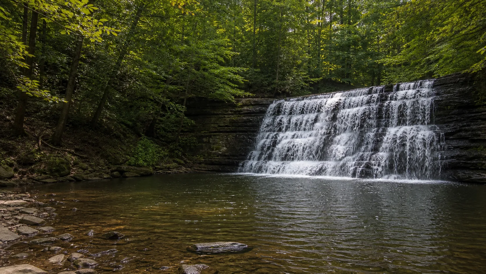
Wadsworth Falls State Park is the only Connecticut waterfall currently published in full on Waterfalls Guide. It holds two drops on the Coginchaug River about a mile apart: a 30-foot horseshoe block called Main Falls (sometimes signed Big Falls) and a 10-foot stepped cascade called Little Falls upstream. Both are reachable on flat, easy walks inside a 267-acre CT DEEP state park, and the live USGS gauge at Middlefield (01192883) sits just upstream of Main Falls so the flow chip on the page reflects what you are about to see. That live-flow pairing is unusual for a Connecticut fall.
There are several other Connecticut falls worth a stop that are not yet published here. Kent Falls State Park in Kent is the most famous in the state, a series of tiered drops totaling about 250 feet of vertical with a paved walk to the lower falls and a steep stair route to the upper drops. Roaring Brook Falls in Cheshire is a tall, thin slide off the basaltic traprock ridge. Buttermilk Falls in Plymouth is a small but consistently photogenic ledge on Buttermilk Brook. Enders Falls in Granby is a series of five small drops in a hemlock ravine on Enders State Forest land. Westfield Falls outside Middletown is a quiet 20-foot drop reached on a short walk from a roadside pullout. The Connecticut DEEP and town conservation-commission pages remain the canonical references for those sites until full guides are published here.
The bedrock story under Wadsworth and most of the central-state falls is the Newark Supergroup, a sequence of Triassic and early Jurassic red sandstone, arkose, and shale that fills the Hartford Basin. Streams cut down through softer beds and stall on harder sandstone ledges, which leaves the resistant layers standing as waterfall lips. The same red sediments preserve the dinosaur trackways famously displayed at Dinosaur State Park in Rocky Hill. The western Connecticut falls (Kent, Enders) sit on different, older metamorphic rocks; the central-state and traprock falls (Wadsworth, Westfield, Roaring Brook) sit on Hartford Basin geology.
Late March through mid-May is the loudest window. Snowmelt and spring rain push the Coginchaug River well above its 30-year daily-discharge median of 36 cfs, often clearing 75 to 200 cfs on big runoff days, which is when Main Falls at Wadsworth reads as a full horseshoe with audible roar instead of a thin split curtain. The same window works for the other unpublished Connecticut falls: Kent Falls, Roaring Brook, and Enders all show their loudest flow in April and early May. The trade-off is that Kent Falls fills up quickly on spring weekends and the out-of-state parking fee kicks in once the gates are staffed.
Mid-October is the second window. Foliage along the Coginchaug gorge and the Litchfield Hills peaks in the second and third weeks of October, which is the cleanest setting for photography even when flow is moderate. The Connecticut Valley reads particularly well at this point because the red sandstone behind the curtain at Wadsworth Main Falls darkens against the yellow and red maple frame.
Late January through February produces partial ice rather than full ice columns. The Coginchaug freezes in patches but rarely forms a full ice column at 30 feet; the lower stairway at Main Falls can be icy from December through March, and CT DEEP does not officially close the path. Winter is the quietest visit window and the easiest parking access, with the trade-off that flow can be low if the previous month has held below freezing.
Summer (June through August) is the lowest-flow window and the busiest at Kent Falls and the swim ponds. Wadsworth's swim pond is lifeguarded and open in season, which is the only legal swimming inside the park; Main Falls swimming is prohibited and enforced.
The published Connecticut fall sits on the Hartford Basin, a Triassic-Jurassic rift valley filled with the Newark Supergroup's red sandstone, arkose, and shale. The Coginchaug River at Wadsworth crosses a more resistant sandstone bed and stalls on it, which holds Main Falls in place as a 30-foot horseshoe. The same red-bed sequence runs from the Massachusetts border south through Middletown to Long Island Sound and is the bedrock story under Westfield Falls and Roaring Brook Falls as well. The iron oxidation that gives the rock its rust color was baked in 220 million years ago when the rift basin was a hot, oxygen-rich semi-arid floodplain, and the same red beds preserve the dinosaur trackways at Dinosaur State Park in Rocky Hill 20 minutes north. Wadsworth Falls is the currently published anchor; the broader cluster reads as one Connecticut Valley sandstone story with several small, free, family-friendly stops on the same geology.
Yes, but not many and not large. Connecticut has a handful of legitimate small waterfalls scattered between the Connecticut Valley and the Litchfield Hills, including Wadsworth Falls in Middletown, Kent Falls in Kent, Roaring Brook Falls in Cheshire, Buttermilk Falls in Plymouth, Enders Falls in Granby, and Westfield Falls outside Middletown. None of them rival the bigger drops in Vermont, New Hampshire, or the Adirondacks, but several are worth a stop on their own. Waterfalls Guide currently publishes Wadsworth Falls State Park in full and points to CT DEEP and town conservation pages for the others.
Kent Falls in Kent Falls State Park, in the western Litchfield Hills, is the most famous waterfall in Connecticut. It is a series of tiered drops totaling about 250 feet of vertical, with a paved walk to the lower falls and a steeper stair route to the upper drops. Waterfalls Guide does not yet publish a full Kent Falls guide; the CT DEEP state-park page is the current reference. The published Connecticut waterfall on this site is Wadsworth Falls State Park in Middletown, a 30-foot horseshoe on the Coginchaug River with a live USGS gauge.
Kent Falls is usually cited as the tallest, at about 250 feet of total cumulative drop across multiple tiers, though no single plunge in the sequence is more than about 70 feet. Roaring Brook Falls in Cheshire is sometimes cited as the tallest single drop at about 80 feet over the basaltic traprock ridge, depending on how the lip is measured. Connecticut does not have any waterfall above 100 feet in a single plunge.
Connecticut residents do not pay for parking at state parks under the CT DEEP Passport to Parks program. Out-of-state vehicles pay weekend and holiday fees from Memorial Day through Labor Day at staffed lots, typically about $15 at Wadsworth Falls and $20 at Kent Falls. Weekdays year-round are free for all vehicles, and the off-season is generally free even on weekends. Walk-in and bicycle access is free. Fees are paid at the gate or via the Reserve America day-pass system.
Mostly no. Swimming in waterfall plunge pools is prohibited at the major Connecticut state parks and is actively enforced. Wadsworth Falls has a documented drowning history at Main Falls and CT DEEP signage is explicit; the lifeguarded swim pond elsewhere inside the park is the legal alternative. Kent Falls also prohibits swimming in the falls themselves. Enders Falls has long had unofficial use as a cliff-jumping spot but the state has posted no-swimming signs after multiple injuries and deaths. The safer answer for a Connecticut waterfall day is to plan a separate swim stop at a state-park pond, a lake, or a designated river beach.
Yes, more than in most waterfall states. The signature Connecticut falls are short, flat, and reachable on easy walks rather than long climbs. Wadsworth Falls Main Falls is about 0.1 mile from the Cherry Hill Road parking lot on a paved path with one short stairway to the lower viewpoint, and the upper overlook is roughly step-free. Kent Falls has a paved walkway to the lower falls. Buttermilk and Westfield are short roadside walks. The trade-off is that wet stone, stairs, and waterfall plunge pools still demand normal waterfall caution, and most of these sites enforce a swim ban.
At most CT DEEP state parks, yes, on a leash up to 7 feet, year-round. Wadsworth Falls allows leashed dogs on all trails but not at the swim pond or its grass areas during season. Kent Falls is also leash-on, with similar restrictions in the picnic and pavilion areas. Town conservation lands like Enders and Buttermilk vary; check the local sign before unleashing. CT DEEP signage requires owners to clean up after their dogs, and rangers do enforce both leash and waste rules.
Plan Wadsworth Falls State Park near Middletown, Connecticut: 0.6 mi route details, parking and directions, best time to visit, safety notes, and 8 waterfall photos.