Compton, Arkansas
Hemmed-In-Hollow Falls
Plan Hemmed-In-Hollow Falls near Compton, Arkansas: 5.5 mi route details, parking and directions, best time to visit, safety notes, and 4 waterfall photos.
209 ft5.5 mi4 photos
Arkansas waterfalls live in the Ozarks, almost all of them are wet-weather only, and the headline is a 209-foot single drop into a 300-foot sandstone amphitheater inside the country's first national river. February through May is the only reliable window.
Arkansas waterfalls are an Ozark story, and the Ozark story is a sandstone story. The Boston Mountains, the high southern half of the Ozark Plateau that arcs through Newton and Searcy counties, are layered Pennsylvanian sandstones (the Atoka and Bloyd formations) sitting on softer Mississippian shales and limestones underneath. Buffalo River and its tributaries cut into that stack over millions of years, leaving bluff lines along the canyon walls and, here and there, horseshoe-shaped recesses where groundwater seepage and freeze-thaw spalling have eaten back into the cliff face. Almost every famous Arkansas waterfall is a small stream tipping over the rim of one of those sandstone amphitheaters.
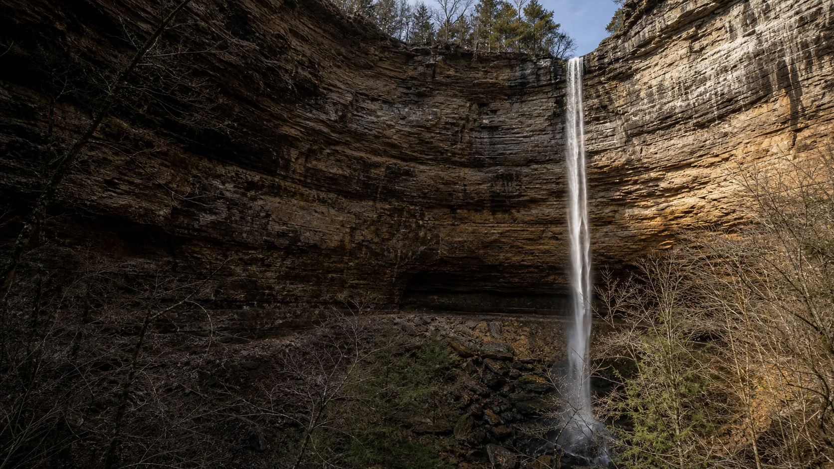
Waterfalls Guide currently publishes Hemmed-In-Hollow Falls in full. It is a 209-foot single-drop plunge in the Ponca Wilderness of Buffalo National River in Newton County, and it is the tallest waterfall in Arkansas. By the standard measure of single-drop height, it is also the tallest waterfall between the Rocky Mountains and the Appalachians, a claim repeated by the National Park Service and the Arkansas Geological Survey. The water falls 209 feet from the rim of a sandstone bluff to the talus floor of the amphitheater without hitting anything on the way down. Buffalo National River, signed into law in 1972, was the first river in the United States to be federally designated a national river, and the park covers about 95,730 acres along 135 miles of free-flowing Ozark river.
The honest framing for Arkansas waterfalls is that the geology is generous, the scenery is unlike anywhere else in mid-continent, and the flow is highly seasonal. The drainages above most Ozark waterfall lips are small and the sandstone above is permeable, so once the topsoil dries out, the falls turn off. February through May is the reliable window, with a second photographer window in mid-to-late October for fall color. By August in a dry year, Hemmed-In-Hollow can be entirely dry, and most of the other published-elsewhere Ozark falls behave the same way. Plenty of Arkansas waterfalls live beyond the one currently published here; the lower section of this page acknowledges them by name. For now, the National Park Service, Arkansas State Parks, and the Ozark Society remain the canonical references for everything except Hemmed-In-Hollow.
February through May is the only window most Ozark waterfalls run reliably. Winter rain and snowmelt saturate the thin soils on top of the Boston Mountains sandstone, the shallow drainages above the bluff lips stay wet, and Hemmed-In-Hollow runs as a full single-strand free-fall rather than a stain on the rock. The same rain that produces the flow also feeds Eden Falls, Glory Hole, Falling Water Falls, Twin Falls of Richland Creek, and the smaller Lost Valley drops; spring is when Arkansas waterfall hunters do most of their driving.
June through September is a gamble. The drainages above most Ozark waterfall lips are tiny (Hemmed-In-Hollow's is roughly half a square mile), the sandstone is permeable, and after about five dry days in summer the falls can go from full flow to a trickle or a dry stain. Visit only within 48 hours of measurable rain in the immediate watershed, and check the nearest USGS gauge before driving. The Buffalo River itself stays floatable in spring and early summer, which is its own draw, but the bluff-line waterfalls are largely off-season.
Mid to late October is the second window, when the first fall rains return some flow and the Boston Mountains hardwoods (oak, hickory, sugar maple) turn through gold and rust against the sandstone bluffs. Crowds are lighter than in spring and the photography is better. November through January is quieter still. Cold-snap weeks in January can produce icicle columns on the bluff faces (Hemmed-In-Hollow's amphitheater is one of the best Arkansas spots for this), but trail ice makes the steep descents hazardous, and the falls are intermittent.
Buffalo National River is the first federally designated national river in the country, signed into law in 1972 after a 20-year fight over a series of proposed Army Corps dams that would have flooded the canyon and most of the bluff country including Hemmed-In Hollow. The park covers about 95,730 acres along 135 miles of free-flowing Ozark river, with three federally designated wilderness areas inside it (Ponca, Lower Buffalo, Upper Buffalo). The Ponca Wilderness, in the western section, is the cluster's headline area and holds Hemmed-In-Hollow Falls, the tallest waterfall between the Rockies and Appalachians at 209 feet, plus the smaller Lost Valley drops (Eden Falls, the Natural Bridge, and a seasonal grotto) on a 2.3-mile family-friendly out-and-back. Ponca (paddle outfitters and a handful of cabins) and Jasper (the Newton County seat, 15 miles south) are the practical base towns. The park is free to enter; backcountry camping requires a free permit. Waterfalls Guide currently publishes Hemmed-In-Hollow in full; Eden Falls and the Lost Valley loop are on the roadmap but not yet a full guide.
The tallest waterfall in Arkansas is Hemmed-In-Hollow Falls, a 209-foot single-drop plunge in the Ponca Wilderness of Buffalo National River in Newton County. The National Park Service lists the height at 209 feet, and the Arkansas Geological Survey confirms it; some tourism sources round to 210. The water falls in a single uninterrupted plunge from the lip of an Ozark sandstone bluff to the talus floor of the amphitheater, without hitting anything on the way down.
Yes, by the standard measure of single-drop height. Hemmed-In-Hollow Falls is listed by the National Park Service, the Arkansas Geological Survey, and the Ozark Society as the tallest single-drop waterfall in the continental United States between the Rocky Mountains and the Appalachian Mountains, a span of roughly 1,500 miles of mid-continent. The qualifier matters: the claim is about a single uninterrupted plunge, not a cumulative cascade. Several Midwestern falls are visually larger because they carry far more water year-round, and some staircase falls elsewhere in the Ozarks are taller end-to-end, but no other single drop in mid-continent matches Hemmed-In-Hollow.
February through May, after winter and spring rain have saturated the shallow soils on top of the Boston Mountains sandstone. That is the only window most Ozark waterfalls run reliably, including Hemmed-In-Hollow, Eden Falls, Glory Hole, Twin Falls of Richland Creek, and the drops at Lost Valley. Mid-to-late October is the second window, with returning flow after the first fall rains and Boston Mountains hardwoods in fall color. Summer is a gamble: the drainages above most Ozark waterfall lips are tiny and the sandstone is permeable, so flow can vanish within five dry days. Visit in summer only within 48 hours of measurable rain.
Because the drainages are small and the bedrock above the lip is permeable. Almost every Ozark waterfall is fed by a shallow stream draining only a fraction of a square mile of land on top of Atoka and Bloyd sandstones, the layered Pennsylvanian caprocks of the Boston Mountains. The sandstone holds some water in its pore space, the thin soils on top hold a little more, and after a stretch of warm dry weather both empty out. The waterfall lip stops receiving water from above and the falls turns off until the next storm. This is why Hemmed-In-Hollow can be a thundering 209-foot single drop in April and a dry stain on the bluff in August of the same year.
Three legal trailheads reach Hemmed-In-Hollow Falls and they are not equivalent. Compton Trailhead is the most common: a 5.5-mile loop (or 5.7-mile out-and-back) from a gravel lot off Newton County Road 19, with about 1,400 feet of elevation loss on the descent and the same gain on the climb back out. Centerpoint Trailhead is shorter at 4 miles round trip but does not descend into the hollow; it ends at a top-of-bluff overlook and you see the amphitheater from above rather than the base. Indian Creek (Kyles Landing) is the river-side approach at 10 to 11 miles round trip with gentler grades, a better choice in hot weather. In spring, paddling the Buffalo River from Ponca or Steel Creek and walking a half mile up Sneeds Creek is the easiest approach of all.
Arkansas has hundreds of named waterfalls, with the densest clusters in the Boston Mountains of the Ozarks and a smaller secondary cluster in the Arkansas River Valley around Petit Jean State Park. Notable falls not yet published as full guides on this site include Cedar Falls (Petit Jean State Park), Eden Falls (Lost Valley, Buffalo National River), Glory Hole (Ozark National Forest), Falling Water Falls (Falling Water Creek), Twin Falls of Richland Creek (Richland Creek Wilderness), and the seasonal drops near Whitaker Point. Waterfalls Guide currently publishes Hemmed-In-Hollow Falls in full; for the rest, Arkansas State Parks, the National Park Service, and the U.S. Forest Service Ozark National Forest pages remain the canonical references.
Buffalo National River is a unit of the National Park Service, but it is not a national park; it is a national river, a separate designation. Buffalo was the first river in the United States to receive that designation, signed into law on March 1, 1972, by President Nixon after a 20-year fight over a series of proposed Army Corps of Engineers dams. The park covers about 95,730 acres along 135 miles of free-flowing Ozark river in Newton, Searcy, Marion, and Baxter counties, and includes three federally designated wilderness areas. The national-river category was created specifically to protect free-flowing rivers without converting them to traditional national parks, and Buffalo became the model used for several later designations.
Yes, though most of the famous Arkansas waterfalls sit a longer drive north or west of Little Rock. Cedar Falls at Petit Jean State Park (Conway County, about 75 miles west on I-40) is the closest 95-foot plunge and the easiest day-trip waterfall from Little Rock. The Boston Mountains cluster (including Hemmed-In-Hollow, Eden Falls, and Glory Hole) is a two-to-three-hour drive north, more practical as an overnight from Jasper or Ponca than as a day trip. Closer in, smaller seasonal drops sit in Pinnacle Mountain State Park west of the city, but none rival Cedar Falls or the Buffalo River bluff falls for scale.
Plan Hemmed-In-Hollow Falls near Compton, Arkansas: 5.5 mi route details, parking and directions, best time to visit, safety notes, and 4 waterfall photos.